On May 30, 1948, the Vanport Flood begins on the Columbia River. Named and most widely remembered for the town that it washes out just north of Portland, Oregon, the flood will crest twice, at 29.95 feet on June 1 and at 29.975 feet on June 14 at Portland, and will not recede for some 20 days. Heavy winter snowfall, a cooler than average spring, and heavy rainfall combined with warm temperatures in late May combine to send raging torrents of water down the Columbia. Running at twice its average spring volume, the river and its equally overflowing tributaries overwhelm levees and flood numerous communities and thousands of acres of farmland in British Columbia, Montana, Idaho, Washington, and Oregon. When the water recedes in late June, the flood waters will have killed at least 50 people, caused about $102 million in damages, and spurred interest in building flood control dams on the Columbia.
Widespread Flooding
In their usual monthly update on April 1, 1948, University of Washington scientists announced that the region's mountain snowpack was 20 to 42 percent deeper than normal. On May 1, they noted that the spring melt had been slower than normal and that the snowpack was still very deep. When temperatures warmed significantly in mid-May and large rainstorms formed, a torrent of snowmelt and stormwater began coursing down the rivers in the Northwest toward the Columbia.
From the river's headwaters in Canada to its tributaries in Montana, Idaho, British Columbia, Washington, and Oregon, the higher-than-average runoff began to cause widespread flooding by May 23. High water closed Highway 10 and Highway 2 in Montana. By May 28, flooding had started throughout the region. Ellensburg and Cle Elum tried to hold back the Yakima River with temporary dikes quickly built as water rose by a foot every four hours. At Bonner's Ferry, Idaho, on the Kootenai River, 25,000 acres of farmland flooded. The Columbia River at Trail, British Columbia, would soon overflow its banks and inundate the town. Rising water threatened bridges throughout the region and disrupted railroad service.
This was neither the first nor the largest flood on the Columbia. The average volume of the river during the spring of 1948 was about 540,000 cubic feet per second. Records on the river kept since the mid-1800s showed the largest flood was in 1894, when the river carried 1.2 million cubic feet per second past The Dalles, Oregon. Another large flood, in 1876, measured about 1 million cubic feet per second. In 1948, volumes reached 1.01 million cubic feet per second on May 31 and stayed at about 900,000 cubic feet per second for nearly three weeks, making it the second-largest flood in recorded history on the river.
Though not the largest, the 1948 flood had a much larger financial impact than earlier floods. Just a few years before, World War II had brought significant industrial development to the Tri-Cities area in Central Washington and to the floodplain area near Portland and Vancouver, Clark County, farther downriver. At the Tri-Cities, the small town of Hanford became the site of the Hanford Engineering Works, part of the Manhattan Project. Its nuclear reactors used the Columbia River's water for cooling and the nearby towns of Richland, Kennewick, and Pasco housed thousands of workers.
In Portland and Vancouver, factories had filled in the riverside lowlands. In 1942, to help meet the demand for housing the nearly 100,000 workers that would work in the factories, Kaiser Aluminum built Vanport just north of Portland's then limits, along the Columbia River opposite Vancouver and immediately west (downriver) of where the Interstate 5 freeway would later cross the river. Vanport helped relieve the general housing shortage and addressed the needs of African American workers who met with extra difficulty in finding housing because of Portland's strictly segregated neighborhoods. The town remained after the war, though its population shrank from a high of about 40,000 to 18,500 by 1948.
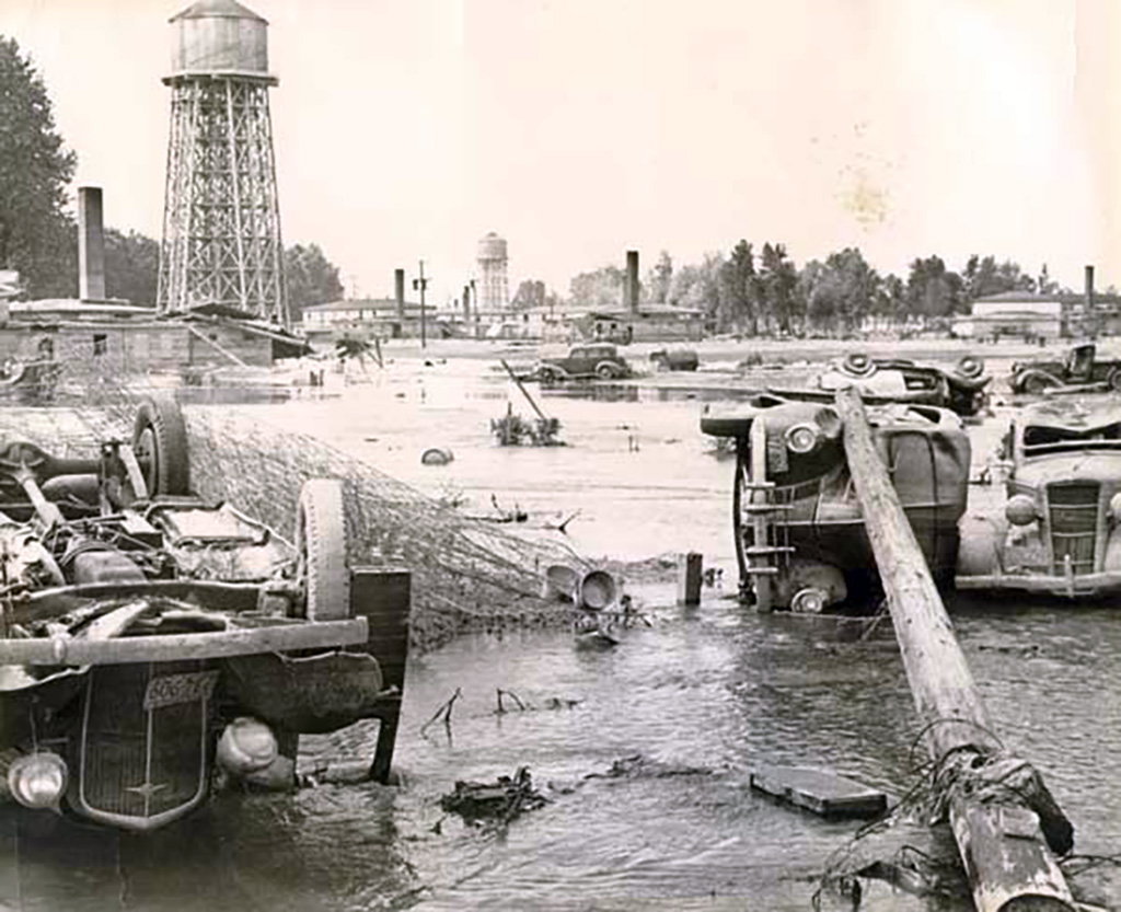
Swept Away
Built quickly and with few provisions made for permanent infrastructure, the town relied on a railroad embankment to protect the west side of the community. On May 30, as the flood waters neared their crest, the Army Corps of Engineers announced that Vanport lay 15 feet below the level of the Columbia River. The Corps of Engineers and local officials kept close watch on the levees and the embankment encircling the town, but did not order an evacuation. In fact, local officials distributed leaflets that morning reassuring residents that they were safe.
At about 4:00 that afternoon, an Army Corps of Engineers crew was inspecting the embankment when, according to Colonel Orville E. Walsh, "the entire section seemed to disappear at once, and both foreman and inspector had to run for their lives" (Willingham, 155). The floodwaters reached the first houses just minutes after the warning siren was sounded and the entire town was covered by 10 to 20 feet of water within an hour. Apartment buildings, swept off their foundations, crumbled into each other. Many residents ran for their lives. Others tried to drive out of the lowlands, but most had to abandon their vehicles and run as traffic clogged the roads. Some had to be rescued from the rooftops of buildings hit too quickly for the residents to escape. The town was a total loss.
Levees and dikes along the river continued to fail as the river remained high for weeks. When the floodwaters receded and the river returned to its banks on June 23, the damage in the United States portion of the Columbia River basin was estimated at $102,725,000, not including losses to factories. The death toll reached at least 51 and more than 46,000 people lost their homes.
Planning for Flood Control
When the 1948 flood occurred, the Army Corps of Engineers and the International Columbia River Engineering Board were already studying the river to determine what flood control, navigation, and hydropower projects should be undertaken. The Corps of Engineers' study, an update of the 308 Report issued in 1932, focused on what types of projects could be built on the Columbia. According to historian William G. Robbins, President Harry Truman (1884-1972) directed the Corps of Engineers to include long-range flood planning as a result of the Vanport Flood. The 531 Report (the titles refer to Congressional document designations), issued in 1950, called for a system of dams that would provide flood control, aid navigation on the Columbia and Snake rivers, and generate power.
The International Columbia River Engineering Board had been formed in 1944 to carry out investigations for the International Joint Commission (which had jurisdiction over issues involving waterways shared across the border) as commissioners considered how the river might be managed cooperatively by the Canadian and U.S. governments to maximize hydroelectric generation and minimize flood damage. The scope of the Board's investigations already included flood control, but the 1948 devastation underscored its importance.
A series of dams subsequently built in the United States and Canada made flooding in the Columbia River basin far rarer and less destructive than it had been. Dams in the American portion of the basin provided some of the flood protection, but the majority of flood storage came from three dams in British Columbia. The Columbia River Treaty, implemented by the United States and Canada in 1964, provided for Canada to construct and operate the Mica, Duncan, and Keenleyside dams in exchange for half of the downstream power benefits resulting from the stored water.
The dams can hold back 15.5 million acre-feet of water during the spring and summer, helping to prevent flooding and allowing for release during the winter, when precipitation in the upper basin falls as snow and the river's level drops. Without the stored water, the hydroelectric generators on the downstream dams would lie idle during those winter months.
As a result of the dams and the management of the river's flow according to the Columbia River Treaty's provisions, the Columbia was transformed into a vastly different river. Its flow became more much even across the seasons and much of the river's length was transformed into slackwater lakes behind the dams. The benefits included cheaper electrical power and safety from floodwaters, but there were also costs, including declining salmon populations and the inundation of culturally important places and resources.
