The 2014 Carlton Complex fire, the largest single wildfire in Washington history, burned 256,108 acres, destroyed 353 homes, and caused an estimated $98 million in damage. The fire caused no direct fatalities or serious injuries, although one homeowner died of a heart attack while protecting his home. Lightning sparked the fire on July 14, 2014, in four spots near the towns of Carlton, Twisp, and Winthrop in Okanogan County on the Methow River. The four fires spread uncontrollably and on July 17, hot winds turned them into a firestorm that raced 25 miles south. It reached Pateros on the Columbia River, and burned down 111 homes. It burned homes and ranches in the Chiliwist Valley, and threatened the town of Malott on the Okanogan River. On July 18, it merged into one gigantic fire and approached the hills around Brewster, burning 47 homes. By July 22, firefighters had stopped most of the advance. By the end of July, the fire was 71 percent contained. On August 21, massive downpours caused devastating mudslides over the bare, ashen landscape. Yet rain helped douse the remaining hot spots and on August 24, 2014, officials declared the Carlton Complex fires 100 percent contained.
Lightning Strikes
The Carlton Complex fire started as four deceptively small blazes, ignited by a lightning storm that rumbled over the Methow Valley on July 14, 2014. The initial fires were the Stokes fire, a mile or two southeast of the small community of Carlton on the Methow River; the French Creek fire, about five miles east of Carlton; the Golden Hike fire, about two miles south of Carlton; and the Cougar Flat fire, about two miles east of Winthrop and more than 12 miles north of the other three fires.
A hot summer had dried out the grass, brush, and timber in the steep canyons and ridges on both sides of the Methow River drainage. On July 15, all four fires began to spread alarmingly. The Stokes fire (sometimes called the Stokes Road fire) was considered the most serious, since it was threatening homes near Carlton. Seven homes along Texas Creek Road were ordered evacuated on the afternoon of July 15 because the fires were "running through grass" and timber ("Evacuations Issued for Carlton Fire"). About 127 firefighting personnel were tackling the Stokes fire, including a Canadian air tanker.
Hot Breezes
On July 16, the fire was whipped up by hot breezes and mushroomed from 1,720 acres to over 7,000 acres. The Federal Emergency Management Agency (FEMA) authorized federal funds to fight the fire and a national interagency team was called in to handle the Stokes fire, as well as the other three fires in the Methow Valley, which had now been dubbed the Carlton Complex. Firefighters arrived from all over the region and set up camp at Liberty Bell High School near Winthrop, within site of the Cougar Flat fire. Cooperating agencies included the U.S. Forest Service, Okanogan National Forest, the Washington State Department of Natural Resources, the Bureau of Land Management, the Washington Department of Fish & Wildlife, Okanogan Fire District 6, Okanogan Fire District 15, and the Okanogan County Sheriff's Office.
On the afternoon of July 16, fire officials began ordering Level 3 evacuations -- the most urgent level. The fire raced into several inhabited areas. Ten homes caught fire and were destroyed in the French Creek area and one in the Carlton area, but the residents had evacuated safely and nobody was hurt. As July 17 dawned, the interagency fire spokesman issued an ominous warning: "It's hot and dry, and as the winds pick up we'll still have conditions that lead to extreme fire behavior" ("11 Homes Lost, More Evacuations in Methow").
Burned to a Moonscape
As the temperature neared 100 degrees, all four fires were whipped into uncontrollable fury by 38 mile-per-hour winds out of the northwest. The result was utter chaos across a huge swath of the Methow Valley and the surrounding mountains. Officials ordered evacuations for hundreds of residents, including everyone living between Carlton and Pateros, which encompassed a 23-mile stretch of Highway 153. Residents descended on the Carlton General Store to stock up on food and gas. Before long the fire had crossed Highway 153 and linked the Stokes and Golden Hike fires. One resident who lived between the two fires said that he "abandoned ship," fled from his home, "drove out in the alfalfa field and sat on the roof of the car and watched the four-foot flames" race across acres of forest and sage toward his home ("Fire Plows Through Pateros"). His farmhouse miraculously survived, but the rest of his land was burned to "a moonscape" ("Fire Plows Through Pateros").
The hundreds of people fleeing from the fires had no way of knowing what, exactly, was happening. Telephone lines went down and cell phone service was vastly curtailed. Thick smoke -- lit orange and red in places -- blanketed the region. Power went out in a huge swath of the Methow Valley after fire turned power poles into torches. Highway 20 and Highway 153, the valley's key arteries, were both closed as the fire raged across. The fires were burning so hot that they created their own flaming whirlwinds. Burning embers and pieces of bark were carried aloft and the fire was "spotting" -- sparking new fires --up to a half mile away. Roads and rivers proved no obstacle as the fires spread every direction — although the main path generally followed the wind to the south and east.
Fighting the Fire
The firefighters, now about 500 strong, were working hard to try to save homes -- and even entire towns -- in the fire's path. Yet nothing could stop the fire from leapfrogging from ridge to ridge. "There is so much going on. It is such a fluid situation," said a beleaguered fire agency spokesman. "Everyone is working to capacity" ("Fire Plows Through Pateros").
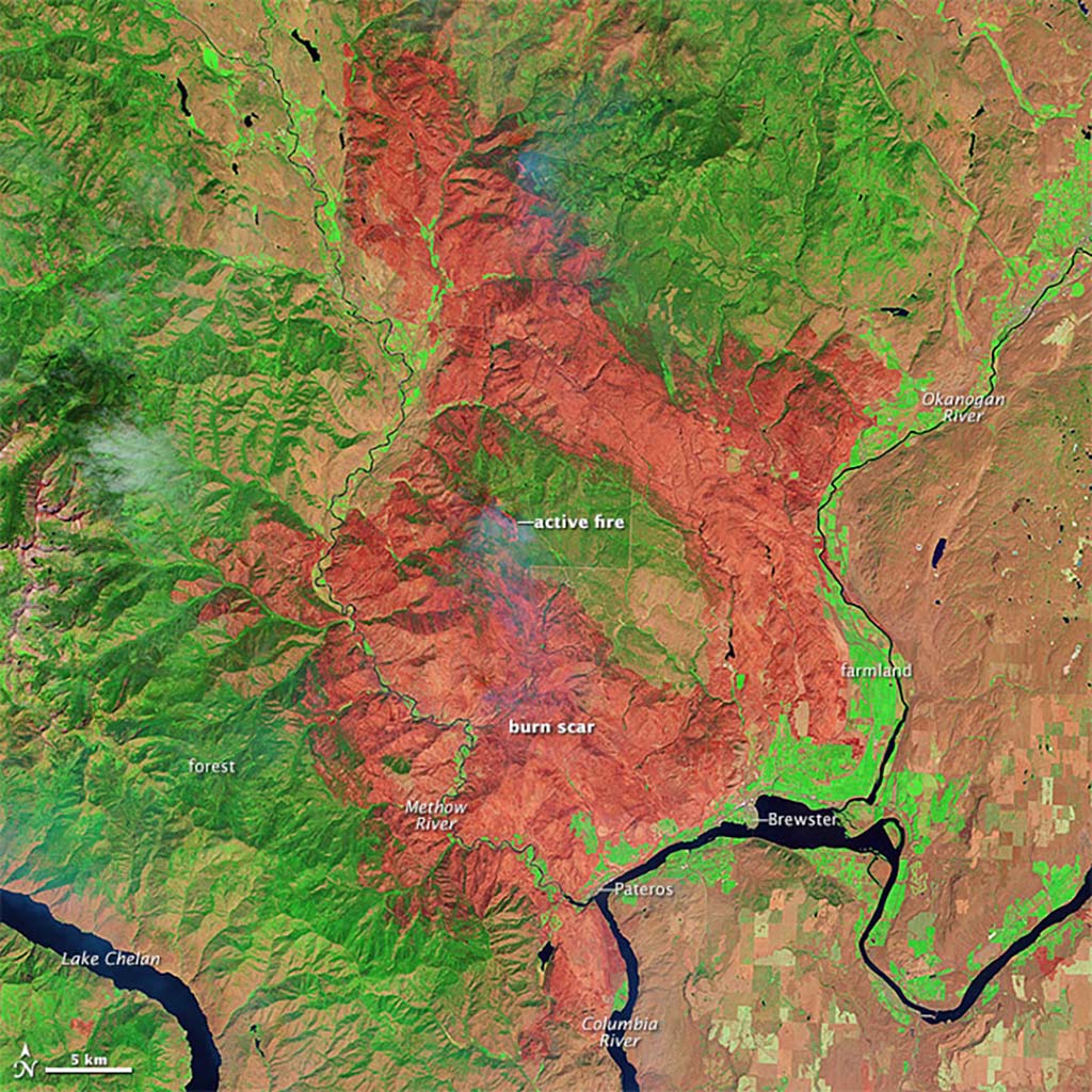
On the morning of July 17, officials estimated that the fire was burning in about 18,000 acres; by 3 p.m. it had grown to 44,553 acres. By the end of the day, the fire had exploded to a staggering 167,712 acres. The Cougar Flat branch of the fire -- the north zone -- had raced nearly 25 miles to the southeast in only nine hours. The south zone branch had burned even farther south, not stopping until it hit the Columbia River near Pateros (Carlton Complex Progression Map).
Pateros
Up until July 17, residents of Pateros had little reason to be alarmed. Pateros -- located on the north bank of the Columbia River where the Methow River enters -- was the valley's safe haven. The Red Cross had just that day set up its evacuation center in Pateros for people fleeing the fires raging many miles north. At 3 p.m. on July 17, the fire was still at least five miles north of Pateros. Yet it was coming fast.
A little after 8 p.m., Pateros caught fire.
"We've lost 4, 5, 6 homes. It seems like the whole town is on fire," said Okanogan County sheriff Frank Rogers, who was working on evacuating more than 300 homes, virtually the entire town (population 667 in the 2010 census) and a large part of the surrounding area ("Fire Plows Through Pateros"). The fire swept rapidly through Pateros and the Alta Lake residential community about four miles away. Miles away in the north zone, residents in the Chiliwist Valley in the hills west of Malott, on the Okanogan River about halfway between Brewster and the city of Okanogan, were forced to escape down the valley as the flames raced over ridges, and torched houses and ranches.
The next morning, Rogers said "It's been nuts. We were on roads telling people to leave and three hours later it was all gone. Everybody's been notified. I just hope they all left" ("At Least 95 Homes Gone").
Houses Burning, People Saved
On the morning of July 18, the sheriff reported that at least 83 houses had burned, including about 30 in Pateros and 40 in Alta Lake, including the Alta Lake Golf Course's pro shop, maintenance shop, and most of the houses lining the course. Nobody yet knew how many houses had burned in the Chiliwist Valley. "Mother Nature is winning here," said a local fire chief. "I don't like to lose structures. It truly bothers me. But there is nothing we can do about this" ("At Least 95 Homes Gone").
The evacuation had accomplished its purpose, however. Nobody was killed or injured. However, people were exhausted after working for hours to protect their homes. All of the displaced people who had taken shelter in the Pateros Red Cross evacuation center were ordered to move again, most of them to Red Cross shelters in Omak, 38 miles away and Chelan, 40 miles away. Additional shelters opened in Twisp and Chelan.
The broad, dammed-up Columbia River was the only thing that stopped the fire's advance on its southwestern front. Yet to the northeast, the north zone fire (originally the Cougar Flat fire) was marching down the west side of the Okanogan River valley and was threatening to join up with the south zone fire and endanger the town of Brewster, also on the north bank of the Columbia River, seven miles upstream from Pateros.
Firestorm
As July 18 dawned, fire officials had switched their focus to Brewster, where they would be "patrolling and monitoring around structures" as well as doing whatever they could along the edges of the increasingly massive fire ("Fire Update," July 18). There was no respite from the hot weather and wind. As the day progressed, fire agency officials described conditions as "extremely active" and "increasingly volatile" ("Brewster Not Being Evacuated"). They called it "one long, continuous fire storm from Davis Lake to Brewster" -- which described an area almost 50 miles long, since Davis Lake is not far from Winthrop, near the original Cougar Flat fire ("Brewster Not Being Evacuated"). In fact, at some point during July 18, the north and south zones of the fire finally converged in the hills just north of Brewster, turning the Carlton Complex into one giant interconnected fire with a total acreage of 215,152 by day's end.
The sheriff ordered evacuations for outlying hills around Brewster, and put the Three Rivers Hospital in Brewster under a Level 1 evacuation alert, which meant that the emergency room was open, but it could not accept new in-patients. Up at the northern end of the fire, residents of Davis Lake and lower Beaver Creek were ordered evacuated and Winthrop was on alert. Meanwhile, the situation had turned ugly on the eastern front near Malott. Burned-out residents of the Chiliwist Valley had fled to an evacuation center in Malott, yet by late afternoon, the sheriff's office ordered all of Malott evacuated as the fire burned nearly all the way to the Okanogan River.
As the evening of July 18 progressed, the situation finally began to stabilize for the first time in three days. With calmer breezes, the fire was "not making wild runs" like it had earlier ("Brewster Not Being Evacuated"). By about 9:45 p.m., the fires had finally stopped short -- just barely -- of Brewster. Most of the Brewster's evacuation orders were lifted. Highway 97 and Highway 153 were reopened. The fires also halted just short of Malott.
Zero Percent Contained
When July 19 arrived, a total of 760 firefighters were battling the Carlton Complex blaze, along with at least 15 helicopters and two planes. A new fear had now arisen. The winds were shifting toward the southwest, putting other areas in danger, including Chelan, Lake Chelan, Winthrop, and Twisp. Now the firefighters were working to hold the western line of the fire. Late in the afternoon, officials ordered the Antoine Creek area evacuated, less than 10 miles from Chelan.
The entire Carlton Complex fire was still zero percent contained and expanding, although not as explosively as before. On July 19, the fire had expanded another 10 percent, to a total of 237,890 acres. The official estimate of burned houses now approached 100 -- but this number would rise dramatically over the next week as people ventured back into the burnt-out areas and found nothing but cinders. Also on July 19, the fire claimed its sole victim, if indirectly. Robert Koczewski, 67, a retired Washington State Patrol trooper and U.S. Marine, had spent two exhausting days working to protect his Gold Creek-area home. He was hauling buckets of water from a creek when he suffered an apparent heart attack or stroke and died.
The Scope of Disaster
The scope of the disaster was beginning to get the attention of the wider world on July 20. Washington Governor Jay Inslee (b. 1951) assigned 100 members of the Washington National Guard to the fire and was making plans to visit the scene of devastation. The fire had become the No. 1 priority wildfire in the nation and firefighters from around the country were pouring in. By the end of the day, the fire crew had more than doubled to 1,622.
The sheer size of the fire remained daunting. On July 20, it had spread another 5,401 acres to a total of 243,291. This meant that it had officially surpassed the biggest fire previously recorded in Washington history, the 238,920-acre Yacolt Burn in southwest Washington in 1902. (An even bigger fire, the three-million-acre Big Burn fire in 1910, had crept into a small sliver of northeast Washington, but the vast majority of that fire burned in Idaho and Montana.) The Carlton Complex fire would ultimately reach 256,108 acres in size. In August 2015 a complex of fires dubbed the Okanogan Complex, which ravaged an area of Okanogan County a little east of where the Carlton Complex burned a year earlier, was reported to have surpassed the size of the 2014 blaze. But then the largest component fire included as part of the Okanogan Complex (the Tunk Block fire) was removed from that designation and counted as a separate fire, because it never merged with the other fires that made up the Okanogan Complex, so the Carlton Complex retained its status as the largest single wildfire in history to burn entirely within the state of Washington.
To more efficiently fight the Carlton Complex fire, officials divided it into three incident management zones, with one based in Winthrop, one based in Omak, and one based in Chelan. By the end of the day, the fire was listed as only 2 percent contained. Yet no houses had burned on July 20 and cooler weather and higher humidity had fire officials optimistic.
Better weather on July 21 did allow crews to dig new fire lines on some parts of the perimeter. However, that afternoon the fires outside of Carlton, Twisp, and Winthrop started making a run to the northeast, once again causing Carlton and other areas outside of Twisp to be evacuated. Fire crews quickly squelched these threats, and the Carlton evacuation order was lifted. By the end of July 21, the fire had expanded another 6,845 acres, to another state record total of 250,136. The fire was now 16 percent contained.
The Turning Point
This proved to be the turning point in the Carlton Complex fires. The fire's expansion was minuscule on July 22 and remained small over the next few days. It also marked a turning point in containment. Over the next two days, containment would jump from 16 to 52 percent. The number of firefighters leapt to 2,858, along with 212 fire engines and 13 bulldozers. They worked at the fire's perimeter, which now stretched for a staggering 182 miles.
"We are throwing everything we've got at this fire while we've got this favorable weather," said a fire spokesman on July 22 ("Weather Helps Firefighters"). President Barack Obama (b. 1961), who flew into Seattle on July 22 for a fundraising event, pledged federal help for supplying generators, power poles, and power lines to restore electricity to a huge swath of central Washington still without power. On July 23, Obama declared a state of emergency in Washington because of the fires.
People in the already burned areas were now returning to see the devastation. As fire crews, deputies, and residents penetrated deeper into the fire zone, the sheriff's official estimate of burned houses would triple to 300 over the next several days. The fire had still claimed no serious injuries or deaths, except for Koczewsi. However, livestock in the area's many farms and ranches had been decimated. Some of the region's famous orchards were damaged because massive power outages prevented irrigation pumps from working. However, most orchards were only scorched around the edges. In the town of Winthrop, power was out for nine days.
A Hellish July
Rainstorms dampened the fire, but now there was a new hazard: flooding. The land was scorched and bare, with no vegetation to hold the topsoil. On July 23, as much as an inch of rain fell in some areas, causing mud flows, including one that briefly blocked a road before being cleared by bulldozers. Meanwhile, shell-shocked residents of the area were attempting to recover. An Emergency Operations Center was set up at Okanogan High School on July 25, and an emergency response team from Pierce County arrived to assist Okanogan County residents with the removal of dead livestock, distribution of donations, and water purification. The American Red Cross operated two Client Service Centers, one in Pateros and one in Twisp. The Red Cross reported that in 10 days it had provided more than 14,000 meals and snacks and 319 overnight stays.
Firefighters, numbering over 3,104, continued to quell hot spots, dig fire lines, and drop giant buckets of water by helicopter. By July 28 the fire was 66 percent contained. However, 105-degree weather on July 29 caused at least one part of the fire to jump a fire line and blaze up a ridge near Gold Creek, west of Carlton. Other areas near the center of the fire flared up again in places with unburned vegetation. On July 30 and 31, Methow and Okanogan Valley residents once again saw towering columns of smoke rising in the hills. These were mostly from hot spots within the existing fire perimeter, but the for the first time in more than a week, the Carlton Complex was growing in size. As a hellish July ended, the fire was 251,698 acres in size and 71 percent contained — and officials were acutely aware that fire season was nowhere near finished.
A New Fire
On August 1, a pocket of fire erupted south of Winthrop -- across Highway 20 from the Carlton Complex fire, but only a few miles from the command center at Liberty Bell High School outside of Winthrop. This new fire, called the Rising Eagle Road fire, was ignited by sparks from a trailer's flat tire. It ran fast through brush and timber and caused officials to evacuate the posh Sun Mountain Resort and about 200 nearby homes. The fire cut the phone lines to the Carlton Complex command center. It also spoiled a visit by Governor Inslee, who had flown to Winthrop to meet with residents.
"We planned to talk about recovery, instead we're talking about a new fire," Inslee said. "It's an indication of how volatile all of Central Washington is" (Camden).
On the other side of Highway 20, the Carlton Complex fire also ran north, threatening Pearrygin Lake State Park and causing it to be evacuated. Fire crews were able to protect most -- but not all -- of the homes threatened by the Rising Eagle Road fire. Ten homes burned, along with many more barns, sheds, shops, and garages. By August 3, the Carlton Complex fire was listed at 253,377 acres, which now included the nearby Rising Eagle Road fire. By August 5, the Rising Eagle Road fire was 100 percent contained.
Stormy weather brought a few more lightning strikes, and the fire perimeter continued to push out incrementally. By August 6, the Carlton Complex fire had reached its ultimate size -- 256,108 acres -- and it was now officially listed as 90 percent contained. On August 9, only 945 fire personnel remained and operations were listed as "patrol and mop up" with only a few hot areas remaining ("Fire Update," Aug. 9). The worst seemed to be over.
Flash Floods and Massive Mudslides
Yet Mother Nature had one more disastrous surprise. On August 21, massive rainstorms rolled in to the region, dropping more than an inch of rain on land that had been reduced to ashes and bare soil. Flash floods and massive mudslides blasted down ravines and canyons, and washed out small irrigation dams. Just north of Carlton, "mudslides knocked a house off its foundation, pushed an occupied vehicle into Benson Creek, trapped a dozen vehicles between slides, and left a mound of dirt and debris five feet thick and 145 feet wide blocking Highway 153" ("Flooding on the Heels of Wildfire").
Mudslide debris blocked Highway 20 between Twisp and Okanogan in several places. Residents of the Chiliwist Valley near Malott, were again stranded when two miles of road washed away. Residents who had spent weeks rebuilding watched helplessly as fences, gates and irrigation systems were washed away. One resident wearily called it "another nail in the coffin" ("Flooding on the Heels of Wildfire"). Near the Carlton Complex command center one firefighter's truck was swept off the road "trapping him temporarily in his vehicle until he was able to self-extricate" ("Fire Update," August 22). It would take weeks for the some of the region's highways to be cleared of obstructions, which further damaged the region's tourist economy.
Catastrophe Beyond Measure
At least the downpours extinguished most of the remaining areas of fire. On August 24, 41 days after the first lightning bolt ignited the first branch, officials declared the Carlton Complex fire 100 percent contained. The command center was dismantled and most of the fire personnel went off to fight other fires. Governor Inslee filed a formal request with FEMA for a major disaster declaration to cover Chelan and Okanogan counties and the Colville Indian Reservation. FEMA subsequently approved a disaster declaration to repair public structures, but the agency sparked anger in the region when it denied a request for disaster aid to individuals who lost home and property, on the grounds that most of the losses were covered by insurance.
Although the fire was lightning-sparked, three people were charged with arson for lighting backfires around their property in an attempt to slow the fire. Those fires threatened fire crews working elsewhere. One of the charges was eventually dismissed, one reduced, and the third still pending as of November 2014.
The final tally of homes lost in the Carlton Complex fire was 353, including 111 in the Pateros-Alta Lake area and 47 around Brewster. Many hundreds of outbuildings were also destroyed. Economic damage was estimated as high as $98 million. Even residents whose families had lived in the area for five generations couldn't recall any comparable disaster. "There's pretty good family history of big events like the '48 flood and bad winters," said rancher Kent Stokes, whose family name was bestowed on the original Stokes Fire. "But they never talked of a fire like this. And it just wasn't to this scale" (King).
In the end, the Carlton Complex fire was, in the words of The Wenatchee World, "a catastrophe beyond measure ... too great for an ordinary detached person to grasp" ("The Long Struggle").
