On December 15, 1917, an article in Seattle's Town Crier magazine includes what appears to be the first stand-alone publication of one of the most famous maps of Seattle, and one with a most curious publication history. The map depicts Seattle on January 26, 1856, when Indians attacked the settlement, and accompanies an article by Beriah Brown Jr. about that skirmish. The map was drawn by Thomas Phelps (1822-1901), who in 1856 was a lieutenant on the U.S. sloop-of-war Decatur. Beyond that is conjecture, or at least some confusion. No original of the map in known to exist. Nor is it known when Phelps drew it or how it made it to Seattle. But we do know that in the 1930s a historian tried to copyright the map and that she lost her case in United States District Court.
Lieutenant Phelps and His Map
Lieutenant Thomas Phelps first arrived in Seattle on the Decatur, a navy warship that had departed from Boston in 1854 and sailed into Elliott Bay on October 4, 1855. It had been dispatched because of settlers' concerns about possible attacks by Native peoples. After his time on the Decatur, Phelps remained in the navy, eventually working his way up to commodore in 1879 and rear admiral in 1884. He retired in 1885 and after his death in 1901 was buried in Arlington National Cemetery.
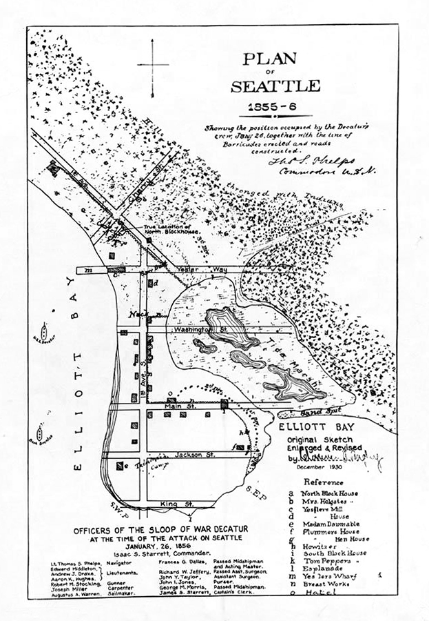
Phelps's map depicts what has become known as the Battle of Seattle, when Native Americans battled settlers and the Decatur's crew on January 26, 1856. The death toll for the skirmish, which ended at 10 p.m., was two settlers and an unknown number of Indians. The map provides what appears to be an accurate depiction of the city on that day, although there is one notable mistake. The settlement's northern blockhouse, or fort, is in the wrong location; it should be two blocks south, at what is now Cherry Street. (Phelps also shows a southern blockhouse, which was not built until two weeks or so after the battle.) The only other map to depict Seattle around the time of the battle is a U.S. Coast Survey map of "Duwamish Bay, W.T." Published in 1854, it shows a roughly similar landscape and distribution of buildings.
Historian Lorraine McConaghy, who has done the most extensive research on the Decatur, wrote in her 2009 book Warship Under Sail: The USS Decatur in the Pacific West that the Phelps map was "likely redrawn and re-inked for publication in the early 1880s" (p. 138). In December 1881, the United Services magazine published Phelps's "Reminiscences of Seattle: Washington Territory and the U. S. Sloop-of-War Decatur During the Indian War of 1855-56," but the map was not included with the article. Nor is it found in reprints of Phelps's reminiscences issued in 1902 or 1908.
The Map in Print
However, in 1908 a version of the map was included in a reprint of Seattle pioneer Arthur Denny's (1822-1899) memoir Pioneer Days on Puget Sound published by Alice Harriman. That edition of Pioneer Days contains what appears to be the first publication of the Phelps map, though it is not a stand-alone depiction of what Phelps drew. Instead, his 1856 map is incorporated into Seattle's 1908 street grid. The published version also includes a note with two corrections of the Phelps map: the improper placement of both the North Blockhouse and the Plummer house.
The next known publication of the Phelps map, and the first time it appeared standing alone, came on December 15, 1917, when it accompanied an article by Beriah Brown Jr. in the weekly Town Crier. Brown's father, Beriah Brown Sr. (1815-1900), had been mayor of Seattle from 1878 to 1879 and was co-founder and publisher of the Puget Sound Dispatch. The younger Brown had worked for his father at the Dispatch, as well as at the Daily Intelligencer, which eventually became the Post-Intelligencer, and at the Press-Times, which morphed into The Seattle Times.
Brown had rediscovered the map while cleaning out his desk. He wrote that Phelps had made the sketch "immediately upon his return to the ship [the Decatur] after the Indians had been finally driven off" ("Seattle's First Taste ..."). Brown had acquired the map from his father, who had been friends with Phelps. Phelps had asked for help from the elder Brown "in putting the whole story [of the battle] in shape for more permanent publication," but both men died before this could happen ("Seattle's First Taste ...").
In 1932 the map, Phelps's written reminiscence of the battle, and a drawing of Seattle he made at the same time appeared together for the first time, when local historian Dorothy Fay Gould published The Indian Attack on Seattle, January 26, 1856, a reprint of Phelps's account, as published in United Services in 1881, illustrated with the map and drawing. (In connection with her book's publication, Gould also let the Seattle Post-Intelligencer publish the map, with a bit of background on how she had obtained it, on January 10, 1932.)
Various Versions, Uncertain Origins
In the book, Gould wrote that she had acquired the map, plus a "skyline drawing" (or profile view) of the Seattle waterfront by Phelps, titled "Seattle W.T. Jany, 1856," from Elsie Meem Kelleher of Seattle, whose late husband Daniel Kelleher had been Chairman of the Board of Seattle First National Bank. In 1931, Elsie Kelleher was closing her home and sent Gould the illustrations. Apparently Kelleher did not provide any information on how she had acquired them, though she did include two letters from Phelps to a Frank G. Gibbens of Portland.
Gould printed Phelps's letters to Gibbens in her book. In them, Phelps explained that he had originally sent the map to United Services but they had failed to publish it with his article. He added that he had prepared the map and drawing for a gentleman who hoped to publish them but had not done so. (It is possible that this is a reference to Phelps's communications with Beriah Brown Sr. but there is no definitive evidence.) The letters imply that Gibbens had plans to publish some sort of document connected with Phelps, but it is unclear if he did, in part because there is no other information about a Frank Gibbens living in Portland in 1882, when the correspondence is dated. The name "Frank G. Gibbens" does not appear in Portland city directories, 1880 federal census records for Portland, or genealogy searches of Oregon around this time period.
Five years after Gould published The Indian Attack on Seattle she submitted her Master of Arts thesis to the University of Washington. Titled "Analysis of Ten Important Private Collections of Northwest Materials Studied from 1930 to 1937 with a Discussion of their Critical Value," it includes a section about the materials from Elsie Kelleher in which Gould states that a Spokane banker named Mr. Vincent had been offered the Phelps skyline drawing. He had declined and suggested that the seller contact Daniel Kelleher. According to Gould, Vincent thought Kelleher had purchased the drawing, and probably the map, for $50.
The map that Gould reproduced in her 1932 book was not a unique copy. Gould wrote that the map had been printed before and had "been corrected by Mr. Bagley where it seemed to show slight variations with Seattle as he remembered it" ("Analysis ...," 41). "Mr. Bagley" was Clarence B. Bagley (1843-1932), who was 17 when he arrived with his parents in Seattle in 1860 and went on to become a printer, publisher, writer, and the city's first prominent historian. Gould's reference is apparently to a printed edition of the Phelps map indicating it was enlarged and revised in December 1930 by Bagley. This version shows the correct location of the North Blockhouse and includes streets on the map, none of which existed in 1856. Bagley also added in the names of the Decatur's officers. Otherwise the map is a copy of Phelps's original map.
We do not know why Bagley produced this map, who he produced it for, or how he distributed it. Nor is an original of it known to exist. Copies are found in the holdings of Seattle Public Library and University of Washington Special Collections. Nor is it known how Bagley acquired a copy of the Phelps map. Perhaps he could have acquired it from whoever supplied the map to Alice Harriman, who published it in her 1908 reprint of Arthur Denny's Pioneer Days. Bagley had originally published Pioneer Days, in 1888, but that edition did not include the Phelps map. Harriman did consult with Bagley so he may have had access to an original, though it is unclear why Bagley would wait until 1930 to produce his edition of the map.
Lawsuit and Unanswered Questions
Gould's connection with the Phelps map continued in January 1944, when Eva Greenslit Anderson took Gould to court. Anderson was the author of Chief Seattle, published in 1943, which contained a reproduction of Thomas Phelps's profile view of Seattle. When Gould found out, she sent letters to local booksellers stating that she owned the copyright to the Phelps sketch and asked them to stop selling Anderson's book. (Gould had filed a copyright claim for the sketch and the map in 1933.) Anderson hoped that her lawsuit against Gould would show that Gould did not own the copyright and that the sketch was in the public domain.
In September 1944, U.S. District Court Judge Lloyd Black ruled in favor of Anderson. Black declared the copyright invalid and ruled that Gould did not have proprietorship over the sketch or map, which were in the public domain. The judge added that it was not the intention of Phelps to retain any special rights to the sketch but to make it available to future generations.
For such a famous map, there are many unanswered questions: When exactly did Phelps draw the original? Does an original exist? Did Phelps produce several copies of the map and send them out to people, including Beriah Brown Sr. and Frank G. Gibbens? How did Elsie Kelleher acquire the map? Did she or her husband buy it from the person who tried to sell them the Phelps skyline drawing? Who was that person and how did he acquire the images? Was it Frank G. Gibbens? Who was Frank G. Gibbens, or did he spell his name differently? How did he know that Phelps had made his map? How did Clarence Bagley obtain a copy of the map to modify before Gould apparently obtained her own copy?
