At 1:30 a.m. on April 25, 2016, eastbound traffic lanes open on the new State Route (SR) floating bridge, fully opening the bridge to traffic. The new bridge, sometimes referred to as the Evergreen Point bridge, spans Lake Washington between Seattle and Medina, and replaces the original bridge built there in 1963. It is a significant upgrade in all respects, and at 7,710 feet, is the longest floating bridge in the world.
Too Old, Too Small
The first SR 520 floating bridge opened on August 28, 1963. It was originally named the Evergreen Point Floating Bridge, but became known as the "520 bridge" after State Route 520, the highway the bridge carries across the lake. It was the second bridge over Lake Washington to connect Seattle to the Eastside, the rapidly growing area east of the lake, and it was a marvel for its day. It was built to last 50 years and it did.
But by the beginning of the twenty-first century it was showing its age. Built to handle 15,000 cars a day, by 2010 the bridge was handling nearly seven times that many. Its aging pontoons had sunk a foot from their original placement and had developed thousands of cracks, which, though repaired, still left them weakened and vulnerable in windstorms. Additionally, the bridge's support columns were vulnerable to earthquakes. But the biggest problem was simply that the bridge was not built to handle the amount of traffic it had to carry. The roadway's shoulders were so narrow (two feet wide in the outside lane and a foot wide in the inside lane) that they were essentially useless. If you broke down on the bridge you were screwed, and so was whoever was behind you.
By the 1990s increasing gridlock on the bridge led to increasing talk of replacing it. In 1997 the Washington State Transportation Commission created the Trans-Lake Washington Study to consider options. These included another bridge between Sand Point and Kirkland, which had been considered at some length in the 1950s for the original bridge, but rejected. By 2003 planners had decided to build a new bridge located just a few dozen feet north of the first one. Multiple designs and lane configurations were next considered. Eastsiders wanted an eight-lane bridge to handle the huge volumes of traffic commuting back and forth to Seattle every day, while environmentalists argued for another four-lane bridge similar to the existing bridge. Eventually they agreed on a six-lane split. By early 2008 a plan was coming into view, and in March of that year Governor Chris Gregoire (b. 1947) announced that the state would have a replacement bridge up by the end of 2014.
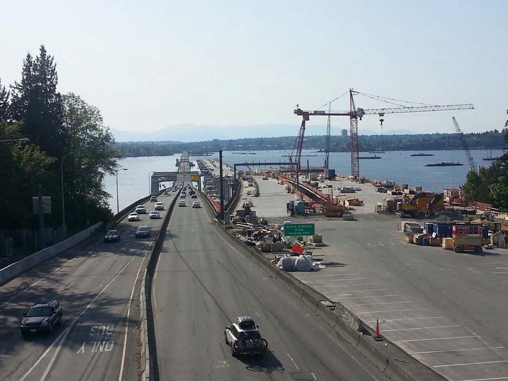
Despite the burgeoning national financial crisis that struck with full force in the autumn of 2008, planning for the bridge continued apace. The first steps toward construction began in February 2011 when pontoon construction began in Aberdeen in a four-acre casting basin. In the spring of 2012 actual construction began with the arrival of pile drivers and excavators on the shores of Lake Washington. By the end of the year, nine of the bridge's 77 pontoons were floating in the lake.
To Build a Bridge
The Washington State Department of Transportation (WSDOT) contracted with Kiewit/General/Manson (KGM), a joint venture, to build the bridge at a price of $586.6 million. Its construction was part of the much larger SR 520 Bridge Replacement and HOV Program, which included widening and other improvements to the SR 520 corridor between I-5 in Seattle and SR 202 in Redmond, a distance of more than 12 miles. (On this part of the project work began in April 2011 with the widening of SR 520 from four lanes to six from Medina to Bellevue.) Funding for the $4.56 billion project came from a several sources, including state taxes (primarily a gas tax) and tolls, which were implemented on the original bridge in December 2011.
Though there was still initial talk of completing the bridge by late 2014, KGM's contract with WSDOT called for a completion date by July 2015. This turned out to be a wise move, because almost immediately problems surfaced. An investigation by Seattle television station KOMO shortly after construction began showed workers drinking on the construction site, leading to the suspension of five managers. However, a far bigger problem soon came to light. In the autumn of 2012 WSDOT found that the newly cast pontoons were cracking. The agency discovered that its engineers had rushed design work for the pontoons in an effort to meet the 2014 completion date, and had failed to properly model the stress forces that would be exerted on the pontoons. Though the cracks didn't create a risk that the bridge itself would fail, they would have let water seep into the pontoons, leading to corrosion that would have shortened the bridge's projected 75-year lifespan. Repairs and redesign cost the state more than $200 million, and pushed the completion date of the project into 2016.
By 2015 most of these problems had been fixed, and that spring and summer the bridge edged steadily westward across the lake toward Seattle. Even then, construction was not without incident. In March a 34-year-old worker fell to his death from the bridge, temporarily suspending construction. The next week, a load of steel pipe being lifted by a crane swung out of control and hit a bus passing by on the original bridge; the wayward pipe then struck a sign which fell on the bus. Eight people were injured.
A (Mostly) Happy Dedication
The final pieces of the road deck were installed in August 2015. The bridge looked nearly finished even though it wasn't, but by the spring of 2016 it was ready for traffic. A gala dedication was held on Saturday, April 2. The weather cooperated with blue skies and pleasant temperatures of about 60 degrees, and an estimated 25,000 and 30,000 people came to stroll the bridge and participate in history. A community "fun run" and walk kicked off the day's festivities. Later in the morning Governor Jay Inslee (b. 1951) spoke and cut a ceremonial ribbon, a representative of Guinness World Records presented a certificate designating the bridge as the world's longest floating bridge (though Guinness pegs it at 7,708.49 feet, a foot-and-a-half shorter than WSDOT's measurement), food trucks on the span provided snacks to visitors, and as morning segued into afternoon, a good time was had by all.
Or actually, most. The bridge was closed to vehicular traffic for the big day, and it was scheduled to be open to the public until 5 p.m. More than 50 buses shuttled people back and forth to the bridge's approaches from Seattle and the Eastside, and at first this worked well. Then, as mid-afternoon approached and thousands of people simultaneously decided to leave the bridge, it began working not so well. By 3 p.m. there was an hour wait for most of the buses leaving the bridge, but other people were still arriving, exacerbating the problem. Officials then announced no more visitors would be allowed onto the bridge so it could be cleared of its first (human) traffic jam, frustrating thousands of people who had waited until later in the afternoon to go the bridge.
Unlike the 1963 dedication of the original SR 520 bridge, traffic did not begin flowing on the new bridge as soon as the ceremonies ended. Westbound lanes opened on April 11 and eastbound lanes opened on April 25. But although the span itself was finished, there was still work to be done.
For example, a new connection to Seattle's Montlake neighborhood from the bridge's western end (the West Approach Bridge North Project) was not scheduled to be completed until the summer of 2017, and until then, bicyclists and pedestrians were unable to cross into Seattle in the bridge's bicycle and pedestrian lane (though they could travel up to the city's edge). Further, now the old bridge needed to be removed. As of May 2016, it was scheduled to be taken down the following autumn.
A Bigger, Better Bridge
Cost overruns of $342 million pushed the bridge's final completion price to $930 million, but the new bridge is a sight to behold. This writer walked the bridge at its dedication and was struck by how its size and scale simply dwarfed the old bridge floating beside it. WSDOT says the new bridge is 7,710 feet long (not quite one-and-a-half miles), 132 feet longer than the original bridge, but it's other comparisons between the two bridges that are more impressive.
The roadway deck at midspan on the new bridge is 116 feet wide, nearly twice as wide as the original bridge. It offers roomy shoulders of four feet in the inside lane and 10 feet in the outside lane, a huge improvement over the old bridge. The deck height at midspan on the new bridge is 20 feet, seven feet higher than the old bridge. It has 77 pontoons, more than double the number of pontoons on the original bridge, and it is built to withstand sustained wind speeds up to 89 m.p.h. Unlike the old bridge, the new bridge has no drawspan, but its east navigation channel is 70 feet high, plenty tall enough for most boats to pass through. Finally, while the original bridge had no bicycle or pedestrian access, the new bridge has a dedicated 14-foot-wide path for both bikers and walkers along the north edge of the bridge.
The bridge's official name is the Governor Albert D. Rosellini Bridge, named after Albert D. Rosellini (1910-2011), Washington state governor from 1957 to 1965 and a proponent of the original bridge. But it's a safe bet that the new bridge will continue to be known as the 520 bridge, just as the old bridge was, even though it too was officially renamed the Governor Albert D. Rossellini Bridge in 1988.
