Seattle's University District, home of the University of Washington since 1895, is located in the northeast section of the city, north of the Portage Bay part of Lake Union. Its main spurs to development were the developer James Moore (1861-1929), the 1895 move of the Territorial University from downtown to what was then called Brooklyn, and the Alaska-Yukon-Pacific Exposition on the University of Washington campus in 1909. In the late twentieth century, the main challenges to this "city within a city" have been the development of nearby malls. It is a neighborhood of restaurants, cafes, a renowned street fair, a farmer's market, and a few venerable institutions such as the University Book Store, University Inn, and the Meany Hotel.
The Survey
The federal land survey that began in Ohio in 1785 reached the future University District of Seattle in the late summer of 1855. Practically all Seattle neighborhoods outside the Central Business District were first deliberately trekked by Euro-Americans in the mid-1850s when federal surveyors dragged 60 foot-long Gunther chains back and forth through the forest that crowded the ridges between Elliott Bay and Lake Washington.
On September 8, 1855, the surveyors marked a line between sections 16 and 17 of Township 24. That line is preserved as 15th Avenue. In the University District it runs north from the shore of Portage Bay.
The Indian Trail From Portage Bay to Union Bay
In their field notes the surveyors wrote that beside the several large specimens of Douglas Fir and Red Cedar along their meridian, there was an Indian trail that crossed it a little ways north of the bay. The path may well have been very old for it linked two Native American communities -- one on Portage Bay near the foot of the present Brooklyn Avenue and the other on Lake Washington's Union Bay. On their survey map the trail is marked by a dotted line crossing the narrow neck of land between the two lakes. In 1883, this isthmus was cut through with a narrow canal for the movement of logs and in 1916 with a wider one for the movement of ships along the Lake Washington Ship Canal.
Since Oregon Territory's Organic Act reserved sections 16 and 36 of every township for the maintenance of public schools, of the land south of the surveyor's meridian line along the future 45th Street, only section 17 directly west of 15th Avenue was open for settlement. Christian and Harriet Brownfield were the first to choose part of it for their own in 1867.
First Settlement
The Brownfields arrived 12 years after the surveyors had completed their work north of Portage Bay. In 1879, Christian's brother Daniel joined him. Of the two brothers, the younger Daniel reached some celebrity. When he died in 1899, he was the last surviving member of Washington's first territorial legislature. In 1875, David Denny (1832-1903), one of Seattle's first pioneers, visited what the Brownfields called their "Pioneer Farm" and described it as "From 8 to 12 acres cleared ... fenced in rail, picket and brush ... . It is in an oblong form. What land is cleared is fertile."
In 1890, when Seattle's super-developer James Moore laid out part of the Brownfield farm for a townsite, there was no assurance that it would become a satellite to a school (Territorial University, later University of Washington). The then still primeval land of section 16, east of 15th Avenue, was reserved first as a resource for the University. It might have been sold to support the building of the school elsewhere. The easterner Moore called his new addition Brooklyn. It was a stretch for although this Brooklyn like the one in New York was situated "across the water" from the larger community, Lake Union was a much wider water than the East River in New York.
In promoting his Brooklyn, the developer gave much more attention to the likelihood that it would soon become an industrial neighborhood than the neighbor of a state university. Moore predicted correctly that his Brooklyn would one day lay beside a canal carved between Lake Washington and Puget Sound. (The Lake Washington Ship Canal opened in 1917.)
A University and a Railroad
However, the prophesized canal was still 27 years distant. Many times more important than the canal was the founding of the University of Washington's new campus in 1895 on section 17. As the neighborhood name announces it, the University defines the neighborhood.
Also more important than the promise of a canal for the new settlement was its connection with Seattle by way of the Seattle Lake Shore & Eastern Railway (since the 1970s the Burke Gilman trail). The railroad preceded Moore by three years. Communities like Fremont, Edgewater, (to either side of Stone Way), Latona (a slightly earlier James Moore addition now part of Wallingford), Ravenna, and Yesler (on Union Bay) were all developed soon after the railroad line reached the north shore of Lake Union and the west short of Lake Washington in 1887. Two years earlier, the engineer and future Seattle mayor George Cotterill (1865-1958), charting the north shore for the construction of the railroad, described it as "a maze of undergrowth and stumps."
Stumps
In 1885 the stumps were new. Much of the north shore was harvested that year, although not the University District. Harry Cowan, a specialist in clearing townsites, cleared 100 acres of that in 1890 for James Moore. The district streets were soon graded and lots sold at a brisk pace. By the spring of 1891, Moore could include in his sales pitch that the state legislature's campus committee had at last recommended section 16 as the new home for the University. By then all the lots of Brooklyn were cleared and one of James Moore's promotions claimed that 50 "beautiful residences were being built by some of the best people in the city." Soon they would be also living within the city.
On May 4, 1891, the first settlers of the brave new suburbia north of Lake Union voted to join the city and the city speedily complied. On June 1, 1891, the border of Seattle suddenly jumped from McGraw Street north to 85th Street. Despite the exclusion of Ballard, Laurelhurst, and part of Ravenna, the 1891 expansion more than doubled the territory of Seattle. The Seattle population, however, was hardly affected. The city of an estimated 40,000 added only 2,500 more persons to its citizenry.
Main Streets
None of James Moore's street names survive. His Tremont Avenue became 15th Avenue. One block west he named University Way -- the District's future "Main Street" -- Columbus Avenue. He called the future Brooklyn Avenue, "Broadway," and this was Moore's intended "Main Street." He called 12th Avenue "Brooklyn."
That University Way and not Brooklyn (or Broadway as Moore named it) became the neighborhood's primary commercial strip was the result of pioneer David Denny's decision in 1892 to lay the tracks for his new electric trolley up Columbus (the future University Way) and not Brooklyn as James would have liked. The suburban railway reached Brooklyn through Latona by way of the Latona Bridge in 1891.
The Students Arrive
With the arrival of students in 1895, Moore's name for the district, Brooklyn, was increasingly dropped in favor of University Station, first named for the heated trolley waiting house built at the northeast corner of University Way and 42nd Avenue. Since at first all but a handful of the school's 450 students lived outside of Brooklyn, the station was a busy one. Soon the Varsity Inn was added to the intersection followed by a collection of small businesses including Sherrick's Hall, a favorite community meeting place at the southwest corner.
In 1902, the Latona Post Office was transferred to University Station, adding to its distinction. By then the official stationery of the University located the school at University Station, not Brooklyn. At that time, the District's future major intersection at University Way and 45th Street was still bordered by a frog pond. Nearby, the trolley tracks bridged a small stream that supplied the Brownfields with their fresh water. The source of that pioneer creek can still be found beneath a trapdoor in the basement of the Wells Fargo Bank at the northeast corner of the intersection.
Corrals for the Cows
The first community activists were the District's first churches -- in 1891 the Methodists, Christians, and Congregationalists. Following the addition of its University, Brooklyn quickly became a progressive community and with its formation in 1901 the Brooklyn Community Club -- well stocked with faculty representatives -- was the energetic promoter of paved streets, sewers, a primary school, a library, and public corrals for the continuing menace of free ranging cows.
Soon after the Brooklyn Community Club was formed, these activists dropped "Brooklyn" from their name and added "University." University Heights School opened in 1903, the same year that 14th Avenue (by then the Community Club's preferred name for James Moore's Columbus Avenue) was both graded and given sidewalks.
The first District library opened in 1906. By the time a new, second street car service reached the University District by way of 45th Street and the Wallingford neighborhood in 1907, the cows had left the streets, gardens, and front lawns of the District along with its last remaining farms.
A-Y-P Exposition
By 1906, it was understood that the University of Washington campus would host the Alaska-Yukon-Pacific Exposition through the summer of 1909. The AYP was a tremendous poker for development in the District. By the year of the fair, traces of the Brooklyn of 1890 were hard to find. From a booming post-fire city of 40,000 in 1890, Seattle had grown more than five fold by 1910. Most of this expansion was to the north in the direction of the University District.
Cowen's Contribution
One of the more effective new citizens north of Portage Bay was the English-born capitalist Charles Cowen. Cowen is remembered by the park he gave to the city (in Ravenna, just north of the University District) in 1907. Cowen was very active in the efforts to fix and clean up the district for the millions expected to attend the 1909 A-Y-P exposition. For a "beautifying" contest sponsored by the women's Coterie Club, Cowen contributed a whopping $500 in prizes. District leaders were so startled by Cowen's generosity that they gave a banquet in his honor at the Congregational Church. At the prize winners' ceremony, Cowen advised, "It was not pure philanthropy that impelled me, but a desire to enhance the value of my property." But he added, "Of course, there is a sentimental side to this for which ... I get more pleasure than from the money."
It is estimated that four million people visited the fair during the summer of 1909. Most likely some of them returned to purchase lots in a Cowen addition. Charles Cowen opened College Inn -- still an "Ave" landmark at 40th Street -- in time for the A-Y-P. Following the fair, the district's first motion picture theater, the Pleasant Hour Theater, opened on January 8, 1910.
A City-Within-a-City is Born
The Alaska-Yukon-Pacific Exposition transformed University Way from its origins as a trolley right-of-way named Columbus Avenue into a commercial strip with realistic ambitions of becoming a cosmopolitan show-strip of specialty shops so diverse that the neighborhood that surrounded it could be considered a "city within a city." Following the introduction of the Wallingford trolley in 1907, 45th Street became the major east-west street in the district. As did 15th Avenue, it too followed a meridian line set by the federal surveyors in 1855.
After the fair the Ave's center steadily moved north from 42nd Street to 45th Street. The Floridian Angus Malloy was one of those who visited Seattle in 1909 to see the fair and decided to stay following it. In January 1910 Malloy announced his intention to build the three-story business and apartment house that still bears his name as the southeast corner of 45th and University Way.
Through the first decade of the twentieth century, University Way north of 45th Street became home to several fraternity houses. In 1901, Phi Delta Theta, at 4542, was the first fraternity established there. By 1906 there were five societies, including the sorority Delta Gamma on 14th Avenue. The Greek migration to its present habitat to either side of University Boulevard (17th Avenue NE) accelerated following the A-Y-P Exposition. In the 1914-1915 University Directory, only one Greek society remains on the Avenue, whereas 11 are listed on 17th and another nine on 18th Avenue NE.
Storefronts quickly replaced the large houses left by the Greeks. In 1915 there were more than 150 businesses on 14th Avenue listed in the business section of the Seattle Polk Directory. That no less than seven confectioners were counted is evidence not only for the sweet tooth of students but also for the legislated ban on alcohol within one mile of campus. In 1895, the year the University arrived, there were only 11 businesses recorded in the same directory for the entire neighborhood.
The first edition of the University Herald appeared on July 6, 1917. The story celebrated the official opening of the Lake Washington ship Canal two days earlier on Independence Day. That it was also the fulfillment of Brooklyn developer James Moore's prophesy, the paper gave no notice. Compared to the contemporary example of neighborhood newspapers, the University Herald would become an impressive publication, for a time running two sizable editions a week filled with local news, much of it of the booming variety.
The Great War
For a year and a half following the institution of the draft on May 18, 1917, the district and its newspaper were preoccupied with World War I. Rallies and Community Sings featuring popular and patriotic songs were features of the District's wartime calendar.
The grandest parade was not planned. News of the November 11, 1918 armistice came at midnight. Many of the thousands of marchers in this spontaneous parade wore their pajamas. The celebrating, which lasted the night, left a few broken windows, establishing an Ave tradition.
In its search for local heroes, the Herald took hold of Joe Forkner, son of the district's mortician. Forkner flew for the Navy during the war. Following it he returned to the district to join the family business. He was by all accounts extraordinarily charming and gregarious. By day Joe Forkner worked on the dead; by night he became the life of the party, a popular impresario who staged entertainments for the many clubs and associations to which he belonged.
At the July 1, 1919 dedication of the University Bridge, the University's venerable history professor Edmond Meany recounted the day a friend of his shot a deer at the corner of 14th Avenue and 45th Street. He also recalled the pioneer Snohomish Wagon Road that passed through the site of the future University, a remnant of which still survived in 1919 behind the school's Forestry Building (near the present location of the HUB -- Husky Union Building). Meany lived near the north end of the bridge.
In connection with the dedication of the new bascule bridge, the University Commercial Club (successor to the Community Club) ran two contests, one to rename 14th Avenue and the other to find a slogan that would best promote the club's "Trade at Home" campaign. District resident J.V. Lynn¹s "Buy and Live; Live and Buy in the University District" won the sloganeering competition. Club member Arthur Quigley's "University Way" won the street name contest easily. To deflect any charges that the contest was fixed, Quigley donated the prize money to charity. On May 23, 1919 the Seattle City Council agreed to the name change.
Later the Club would attempt to rename the University District with yet another contest. District resident Arthur Rarig won the contest and the $25 price by giving the best reason for keeping the old name. His was an organic defense. "University District, like Topsy" was a name that "just grew." UniverCity, won second place. In 1986, retired District banker Roy Nielsen revived it for the title of his history of the University District.
From Hats to Books to Bartell's
For 51 years, Martin and Eckmann's was the preferred men's haberdashery on the Ave. Ray Eckmann and Carol Martin joined their talents in 1922. In 1936, Eckmann was named Athletic Director of the University, and during World War II, he was a big booster of war bonds, staging rallies for their sale on the corner of 45th Street and University Way. Also in 1922, Roosevelt High opened north of the Ravenna ravine and Charles Cowen's namesake park. The Wilsonian Apartments at 47th Street and University Way were a 1922 addition as well.
Four years later, the University District's most distinguished resident and the first woman mayor of a major American city moved into the Wilsonian. Bertha Landes (1868-1943) came to Brooklyn in 1895 with her husband Henry, then the school's new professor of geology.
Also in 1926, Bartell Drugs opened its 11th store in the Malloy Building at 45th Street. Although the pharmacy would later temporarily leave the location, it has long since returned to it.
The University Book Store completed its first full year at its "off-campus" location in 1926. It almost instantly became the commercial anchor of the Ave it still is. The addition in 1928 of the J.C. Penney Department Store north of 45th Street added to District¹s boast of amounting to a "city within a city."
The U District's Great Depression
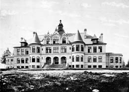
Planning for the University District's surmounting landmark, the Edmond Meany Hotel, began in 1929 before the great market crash in October. When the site of the tower hotel was made public on January 28, 1930, none of the members of the University Community Hotel Corporation believed that the depression was anything but temporary. The Meany was financed by private subscriptions -- it was a show of University District patriotism.
Judged by the volume of construction during 1930 in the District -- three times that of 1929 -- the investor's confidence seemed warranted. However, when the Edmond Meany Hotel was dedicated by its namesake professor with a grand opening on November 11, 1931, the bad times were still getting worse. Six years later the hotel was required to reorganize under federal bankruptcy laws.
The Great Depression, we know, was often good for art. In the District, theater thrived with Burton and Florence James' Repertory Playhouse at 41st Street and the Glenn Hughes' Penthouse and Playhouse theaters. Hughes, the head of the University of Washington Drama Department also ran a series of foreign films at the District's Egyptian Theater during the Depression.
When it opened in 1937, the District's new gleaming white Post Office at the southeast corner of the Ave and 43rd Street featured Works Progress Administration murals in the lobby. After the lobby was moved to the basement in 1982, this example of WPA art was effectively closed to the public. (At the time of this writing -- 2001 -- the on-and-off-again efforts to move the murals to the University District Library are off again.)
Cal McCune's U District
Calmar McCune (1911-1996), a District citizen of such endurance and influence that he was informally called its "Mayor," arrived as a UW law student in 1933. To support his studies he worked as a dishwasher at the popular Wiseman¹s Restaurant at 4334 University Way. Upon passing the bar, "Cal" set up practice in the District, joined its clubs like the Lyons and Chamber of Commerce, and eventually with his daughter Leslie Grace opened the La Tienda Folk Art Gallery, one of the Ave's surviving small businesses.
It was McCune who led the successful mid-1960's struggle to keep the Meany Hotel a hotel rather than retirement home. Before his death in October 1996, Cal McCune published his memories of an activist life in the University District. The title From Romance to Riot is suggestive.
With the Neptune Theater first in 1922 and the Egyptian Theater second in 1925, the University District and its student population got big movie theaters. The Varsity Theater was added in 1940, the year that the district's most nostalgic noise was eliminated. On May 11 the last of the streetcars clattered up the Ave. Although dull by comparison, the trackless trolleys that took their place were relatively silent.
On the Ave, like everywhere, the direct involvement of World War II for Americans with the bombing of Pearl Harbor changed occupations and preoccupations. For those who were not shipped abroad (or to internment camps as Seattle's Japanese Americans were), there were civil defense units, rationing boards, and lectures on the enemy. Retail stores were kept open on Thursday evenings from 7:00 to 9:00 o'clock for defense workers.
When needed, a platform was moved to the middle of 45th Street, where the street climbs just east of University Way. From that roost, with the aid of music, rousing speeches from civic leaders, appearances of celebrities including actresses and community queens looking something like the cartoons painted on the sides of Boeing¹s B-17s, citizens were cajoled and bonds were sold.
Post-War Years
District changes that followed World War II were as noticeable as during it. By 1950, the University of Washington enrollment nearly tripled over its wartime low of barely 5,000 students. The swelling was created primarily by returning veterans carrying their "G.I.Bill" package of benefits and college loans.
Suddenly University Way was plagued by traffic jams. District leaders had responded already in 1946 with parking meters and the University District Parking Associates. The still active University District Parking Associates paved and painted lines on its first lot on Brooklyn Avenue directly north of the Meany Hotel.
By the twentieth century's halfway mark, the University District and its principal strip University Way were easily the best example Seattle-wide of a "city within a city." In 1950, the first annual Seafair Kiddies Parade marched down an Ave lined with students, leaders, and parents.
Also in 1950, the long proposed ceremonial gateway to the University opened with the dedication of Campus Parkway. However, another mid-century north-end development was not so sanguine for the University District.
The Mall Challenge
What its builders claimed was the first mall in America opened four miles north of the District in 1950. Access to the Northgate Mall -- a sea of parking surrounding an island of shops -- was made even easier in the early 1960s with the opening of the Interstate-5 Freeway.
By then a second oversized shopping distraction for north end consumers was available directly west of the University District beside the old community of Ravenna. University Village was built partly over the wetland at the head of Union Bay exposed at the 1916 lowering of Lake Washington to the level of Lake Union for the opening of the ship canal. The 1956 opening of University Village was especially injurious to commerce on the Ave.
These indignities were predisposed by the original remoteness of Brooklyn in 1890. In the 1950s, there were still north end sites available to be developed with malls capable of serving the car-directed culture that at last took control following World War II. Neighborhoods closer to downtown like Capitol Hill could later nourish and develop their business strips without the drain of competing malls. The greater vitality of Capitol Hill's Broadway Avenue over the University District's University Way -- both commercially weighted to the interests and tastes of youth -- at the beginning of the twenty-first century may be partly explained by pioneer choices and post-World War II opportunities.
University Expansion
In 1960, the University of Washington began the development of its new "South Campus." Attention to developments south and east of the main campus was spirited by the success that year of the University of Washington's football team. The Huskies upset Wisconsin in the Rose Bowl. Running interference for the school in its plans to develop the area south and southwest of the main campus was the federally funded "Northlake Urban Renewal Project." The community strife connected with the project's displacement of businesses and residents has never completely settled.
Walt Crowley summarizes the mood of the District and its "Main Street" in 1960 as still optimistic.
"Despite anxieties about the UW's appetite for real estate and competition from Northgate and U Village, the District closed the decade prosperous and confident. Between 40th and 50th Streets, the Ave was a small city with a major department store in Penneys, two variety stores, a grocer, four drug stores, four book stores, a large printing company, numerous clothiers including Nordstrom and Lerners, more than a dozen restaurants and cafes, and scores of specialty retailers catering not only to students but to a nearby residential population of more than 30,000. The Ave proudly advertised itself as "A Department Store Eight Blocks Long," and the future looked bright. No one in 1960 anticipated that the Ave would become a battle ground in a virtual cultural revolution just a few years hence" ("The Ave...").
In 1964, the University District got a new elevated landmark to rival the Meany Hotel -- and to block it. The monumental SAFECO logo atop the Brooklyn Building across 45th Street from the hotel featured a 96-foot-long reader board. It instructed drivers on the relatively new Interstate-5 freeway with messages promoting the company's offerings and with greetings like "MERRY CHRISTMAS" and "BIG BROTHER IS WATCHING."
The Sixties on the Ave
The "Sixties" may be said to have started in 1965. That year the first campus "teach-in" on the Vietnam War was followed by a protest march at Westlake Mall in downtown Seattle. A blend of youth, bohemian, and the remnants of beat culture then patronized the District's several coffeehouses. The Pamir House, the Edge, and the Eigerwand Kaffeehaus came out of the folk singing "Hootenanny" movement that flourished in the early 1960s. A taste for psychedelics -- the first marijuana bust in the district came in 1965 -- the imported music and loose locks of English rock bands, a tone that was at one moment ironic and the next super-sincere joined with anti-war sentiments to create the Hippie.
In parody of the University Herald's call in 1965 to crack down on what the paper called the District Beatniks, a group of District artists promoted the 1966 "Second International Bohemian Festival" which like the first was a non-event which nonetheless the local media including the Herald chose to treat as prelude to what a year later they would call the "Hippie Invasion."
California was identified as the primary source for the flocks of "flower children" that swarmed the Ave during the 1967 "Summer of Love." During the late 1960s the Ave was Seattle's version of a combined Haight Street in San Francisco and Telegraph Avenue in Berkeley. The real source for the Hippies themselves, however, was rarely California and more often Ballard, Bothell, and the University District itself.
The Free University of Seattle (FUS) located above the Coffee Corral at 42nd Street and the Ave, and the Helix newspaper that was started there in 1967 were two popular institutions of those years that served the interests of what was increasingly called the "counter culture." With the escalation of the war in Vietnam and, in the District, a strategy by many Ave merchants of discrimination against "long-hairs," the counter culture also became increasingly contrary.
University District Movement
The University District Movement of 1967 was a combined response of marches and sit-ins of students and street persons to these local events. On-campus protests against the war involved an alliance of often thousands of students and citizens from every part of Seattle. The latter were attracted to the District and its university to be part of the marches that often streamed from campus and through the district before continuing downtown -- on one notable occasion in 1970 by way of the Interstate-5 Freeway.
The Ave also had its own riot -- named variously the "Hippie riot of 1969" and the "police riot of 1969." One of the unexpected effects of those two nights of broken windows, police batons, tear gas, and arrests was a series of conciliatory meetings held afterwards by representatives of the "hip community," merchants, and district leaders. Cal McCune and Walt Crowley, activists respectively on the merchant and street sides, became friends as a result of their participation in these meetings.
The short-lived University District Center and the still going University District Street Fair were both responses to the stresses of those times. The Center opened in a house on the "Upper Ave" on April 5, 1970. The city's new mayor, Wes Uhlman, attended the official opening of the Center that his office helped to fund.
Less than two months later, the first U District Street Fair closed the Ave to normal traffic between 41st and 50th streets and replaced it with arts and crafts booths -- about 300 hundred of them. Nearly 50,000 people visited the Fair. Two years later the number had more than doubled. University District merchant Andy Shiga (1919-1993) is credited with providing both the inspiration and perspiration to create the fair and make it work. SAFECO community relations director Ron Denchfield also played an important part in the early going. Soon after, Susan Harris and Lyn Dorgan took on the routine of managing the fair. The pair continued to bring it off successfully through the year 2000.
The Pedestrian Mall Plan
The success of temporarily closing off University Way for strictly pedestrian use revived a plan first suggested by Victor Steinbrueck to merchants in 1955. The activist UW professor of architecture suggested that the Ave be turned into a pedestrian shopping mall. The University District Development Council unveiled its design to close the Ave to all traffic from 41st to 50th streets on December 8, 1971.
It was poor timing, for the city was then in the midst of its "Boeing recession." U District realtor Don Kennedy was the principal activist against the plan. Kennedy contacted the District's many absentee property owners in his campaign. Distant owners could not be expected to share the concerns of engaged merchants and district residents. Since the plan required owners to pay the costs for its first stage and 60 percent of them were needed to sign-on, the pedestrian mall remained a vision. Crowley notes "Whether or not one agrees that the mall was a good idea, its defeat had a broader significance: the last, best chance for the community to shape the Ave's destiny had come and gone."
Developments in the University District through the last quarter of the twentieth century were determined both by trends active well beyond its borders but also by the phenomenal growth of its neighbor, the University of Washington. Enrollment swelled into the thirty thousands. On both its residential and business sides the University District increasingly became subject to the needs and tastes of students.
Although housing proposals like the Scope Corporation¹s 36-story apartment house on 12th Avenue were stopped by the University District Community Council formed in 1970 to defeat them, ultimately many of the large homes north of 45th Street were sub-divided into closet-sized living spaces for students and others for whom any chance for graceful living in the University District was closed. So was University Heights Elementary School in 1989, the victim of changing demographics in which fewer families with children were living in the University District.
Still youth -- slightly older youth -- will have its way. Much of the remaining housing stock in the University District is rented not only by students but also by young artists and musicians and the sound of practicing bands can still be heard in the streets. During the 1980s, the local bands Pure Joy, Room Nine, Feast and Chemistry Set were all living in rented houses on 11th Avenue near 52nd Street. Chemistry Set named their rental Maldeb or bedlam backwards, and the parties held there are now remembered as legendary -- even by those who attended them. Those times and places are recounted in Clark Humphrey's book Loser.
Few District businesses from the "Sixties" have made it into the twenty-first century. Among them are Bartell Drugs, District legend Charles Cowen's The College Inn, Cal McCune's La Tienda Folk Art Gallery, Werner's European Café, the Continental Café, Porter and Jensen Jewelers (moved to University Village in spring 2002), the University Book Store, and squeezed on both sides by the expanding book store, Shiga's One World Shop.
Among those departed are J.C. Penney, Martin & Eckmann's, Jay Jacob, University Radio (a target of the 1969 riots), the Hasty Tasty (once the District's favorite greasy spoon), Benton Jewelers (and its elegant sidewalk clock), Nordstrom Number 2, and most recently the Last Exit. Opened originally on Brooklyn Avenue in the early 1970s, the Last Exit was a latter-day "victim" of Campus expansion to the southwest. This coffee shop with chess and checker tables and its own library moved to the "Upper Ave" in the 1990s, where it died in the year 2000.
A revitalizing addition was the University Heights Farmer's Market, which opened on the erstwhile elementary school's old play yard in May 1993. By 1999, the market was drawing 100,000 shoppers during its May to November season.
