On December 26, 1854, at Medicine Creek in present-day Thurston County, members of the Puyallup, Nisqually, Steilacoom, and Squaxin Island tribes enter a treaty with the United States in which they cede nearly all their lands, retaining three tiny reservations and access to traditional hunting and fishing grounds. The treaty with Indian communities of south Puget Sound is the first in a series that Governor Isaac Stevens (1818-1862) makes in a few months with tribes across Washington Territory. The Medicine Creek Treaty contains marks purporting to represent the signatures of 62 tribal leaders, but not all those actually sign. They and others object to the inadequate reservations provided. Dissatisfaction with the Stevens treaties will soon lead to armed conflict between some Indian forces and U.S. troops and settlers. Although the U.S. prevails, in August 1856 Stevens will meet with Puyallup and Nisqually leaders and agree to significantly larger reservations for both tribes. More than a century later, Medicine Creek tribes' successful efforts to enforce treaty fishing rights will play a significant part in a nationwide movement for Native American rights and sovereignty.
The Treaty Tribes
The Treaty of Medicine Creek is an agreement between the United States and "the Nisqually, Puyallup, Steilacoom, Squawskin, S'Homamish, Stehchass, T'Peeksin, Squi-aitl, and Sa-heh-wamish tribes and bands of Indians, occupying the lands lying round the head of Puget's Sound and the adjacent inlets" (Treaty, preamble). Those lands, ceded to the U.S. in return for $32,500 and other government assistance, encompassed some 2.5 million acres extending from south Puget Sound to the slopes of Mount Rainier, and from the crest of the Cascade Mountains to the summit of the Black Hills west of present-day Olympia.
The names of the listed "tribes and bands" derive from watersheds occupied by different groups. Six are the traditional names of six of the seven southernmost inlets of Puget Sound where the ancestors of the present Squaxin Island Tribe lived -- Squawskin (or "Squaksin"), now Case Inlet; S'Homamish (or "S'hotl-Ma-Mish"), now Carr Inlet; Steh-Chass (Budd Inlet where Olympia is located); Squi-Aitl (Eld Inlet); T'Peeksin (Totten Inlet); and Sa-heh-wamish (Hammersley Inlet). Those living on the inlets, where they harvested salmon and shellfish, were known as "People of the Water," traveling the seven waterways and far beyond in large seagoing cedar canoes. The small island in Peale Passage just north of Budd Inlet, designated in the treaty as a reservation and now known as Squaxin Island, was not historically a village site but a gathering place for trade and celebrations.
The Steilacoom people lived in five bands -- Steilacoom, Sastuck, Spanaway, Tlithlow, and Segwallitchu -- along Chambers Creek (also known as the Steilacoom River) and nearby lakes and creeks flowing into southeastern Puget Sound where the cities of Steilacoom and DuPont are now located. Although parties to the Medicine Creek Treaty, the Steilacoom did not receive a reservation of their own in the treaty or later. Some moved to other reservations, but many continued to live on their traditional lands and organized their own tribal government. While not federally recognized, the Steilacoom are recognized today by some government agencies.
The final two peoples listed, the Nisqually and Puyallup, lived in many villages along the rivers named for them, both flowing from Mount Rainier to Puget Sound. The Nisqually enters the Sound at the Nisqually Delta, some 10 miles east of Olympia, with much of the river's length now marking the boundary between Thurston and Pierce counties. Farther northeast, the Puyallup flows into Commencement Bay, where the Port of Tacoma is now located. Both people's Lushootseed names commemorate their river homelands. "Squalli-absch," from which "Nisqually" derives, is translated "people of the river, people of the grass" ("Heritage"). "Spuyaləpabš" or Puyallup means "people from the bend at the bottom of the river," referencing "the many dispersed villages that spanned outward from the mouth of the Puyallup River" ("Puyallup Tribe: The Story ...").
Both valleys encompassed a range of landscapes, from saltwater shorelines at their mouths to river shores, tributary creeks, and prairie grasslands farther inland. Villagers at different locations along the rivers could live quite different lifestyles, taking advantage of the resources around them. Near the Sound, Nisqually and Puyallup people, like their Squaxin and Steilacoom neighbors, fished and harvested shellfish. Bountiful runs of salmon extended far up the rivers, and people there caught large numbers using elaborate weirs. They traveled on river canoes and by horse. Upriver villagers used controlled burning to maintain open prairies in the valleys where they cultivated camas, potatoes, and other crops, and pastured large herds of horses.
Newcomers and Conflicting Land Titles
The earliest non-Native settlements on Puget Sound occurred on the homelands of the tribes that would enter the Medicine Creek Treaty. First to arrive was the British-owned Hudson's Bay Company, which in 1833 built Fort Nisqually near Sequalitchew Creek not far from the Nisqually Delta in what is now DuPont. The fort began as a fur-trading outpost and later also included an extensive farming operation. Native Americans, accustomed to trading with each other and more distant tribes, welcomed the company as neighbors and trading partners.
A dozen years later in 1845, the first U.S. citizens to settle on Puget Sound, led by George Bush (1790?-1863) and Michael T. Simmons (1814-1867), settled near the falls of the Deschutes River where it enters Budd Inlet, now the site of Tumwater. As with the Hudson's Bay Company, local Indians welcomed and assisted the newcomers. Nisqually leader Leschi (1808-1858) brought them supplies and later encouraged James McAllister (1812-1855) and his family to homestead in the Nisqually Delta on what the Nisqually called She-nah-nam (Medicine Creek) and later became known as McAllister Creek.
Although relations with these first newcomers were good, tensions rose as settlement steadily increased. A significant contributing factor was the 1850 Donation Land Claim Act, which encouraged U.S. settlement of Oregon Territory (then including the future Washington) by allowing white settlers to claim legal title to land they settled. In passing the act, Congress ignored long-standing principle, dating to Great Britain's colonial rule, that Native Americans held legal title to lands they occupied until they relinquished that title in treaties. Federal courts and officials understood the U.S. Constitution required treaties with Indian nations to be ratified by the Senate just like treaties with European countries and recognized Indian tribes as domestic sovereigns who could enforce treaties they made under U.S. law.
As the U.S. expanded westward, the government first generally followed a policy of removal -- treaties required tribes to give up all their lands and move farther west, beyond current non-Native settlement. However, by the early 1850s, with ever-increasing numbers crossing the continent to the Pacific Coast, removal beyond the range of non-Native settlement was no longer possible and a new policy was adopted. In treaties ceding Indigenous homelands to the U.S., small portions of land were "reserved" to the tribes -- creating the reservations that would become central to tribal life and governance over the years. But until treaties were made, the tribes still held title to the land, which the Donation Land Claim Act ignored.
The problem was exacerbated on both sides by the fact that non-Native settlers in the Puget Sound region were attracted to exactly the lands that tribes lived on and used -- prairies they managed by burning and garden plots they cultivated offered far-more-appealing farm sites than stands of large timber that had to be painstakingly cleared. White settlers "became increasingly aware of the intolerable injustice of having good farm land in the hands of ... a race they regarded as savage" while "with some shock the Indians found their potato lands were open to expropriation by the first white man who wished to avoid hard labor with the ax" (White, 32).
Between 1852 and 1853, when Washington Territory was created, the non-Native population of the area doubled and "the federal government, in a desperate rush to secure rights to the ancestral lands of tribal nations, pushed for a treaty resolution" (A People's History ..."). Leading the push was Isaac Stevens, the first governor of Washington Territory and superintendent of Indian affairs for the territory.
Writing the Treaty
Shortly after reaching Olympia (which he named territorial capital) in November 1853, Stevens embarked on preparing treaties, working with two men who would "be his primary aides in dealing with the Indians of the Sound" (White, 52) -- George Gibbs (1815-1873) and Michael Simmons. Gibbs, an attorney, geologist, and ethnologist, wrote some of the first studies of Northwest Native cultures. He participated in the railroad survey that Stevens led on his way to Olympia, for which he wrote a detailed report on local tribes that included "a preliminary program for the treaties" (White, 53), and he became the primary drafter of the treaties Stevens made.
In his report Gibbs had formulated what would become the most significant provision of the Medicine Creek Treaty and others in Washington Territory. He proposed that in addition to reservations, "free pasturage on unclaimed land and the right to fish at their usual places would be guaranteed," so that "in effect [reservations] would be large village sites from which the native economy would be able to function" (White, 53).
In March 1854 Stevens named Simmons Indian Agent for Puget Sound. Gibbs and Simmons both believed that, especially in the Puget Sound region, there should be a number of smaller reservations, rather than consolidating many tribes onto one or a few larger tracts, which the federal Office of Indian Affairs preferred. Gibbs noted the risk of conflict if many disparate groups were forced to live together. Simmons, as a longtime settler, recognized local Indians' critical role in the economy, as a source of labor for non-Native enterprises and as trading partners providing settler communities with food and supplies.
In August, after Stevens had returned to Washington, D.C., to lobby for it, Congress finally approved funding for the treaties. Along with the funds, Stevens received instructions from Acting Commissioner of Indian Affairs Charles Mix with copies of treaties recently entered with the "Omaha and Ottoe and Missouri Indians" (Meeker, 237), which were among the first establishing reservations. Once Stevens returned to Olympia in December, he wanted to deal quickly with all the Indians of Puget Sound before turning to tribes east of the Cascades. But despite the federal preference for few reservations, Gibbs and Simmons convinced Stevens that they needed to provide a larger number, which meant making multiple Puget Sound treaties.
Those treaties would in no sense be negotiated -- Stevens's team wrote them and the tribes were merely requested to sign. Except for specifics of Indian participants named, lands ceded and price paid, and reservations created, the language of all the Western Washington treaties was largely the same, most of it based on the "Omaha treaties" Mix sent as models. The one major addition was what Gibbs proposed:
"The right of taking fish, at all usual and accustomed grounds and stations, is further secured to said Indians in common with all citizens of the Territory ... together with the privilege of hunting, gathering roots and berries, and pasturing their horses on open and unclaimed lands" (Treaty, Article 3).
While Gibbs, Simmons, and Stevens could hardly have foreseen the impact this provision would have a century and more in the future, they had ample motivation for including it. They knew the tribes would not give up the vast majority of their lands if they also lost all access to the resources that sustained them, and at treaty councils Stevens made a point of acknowledging tribal leaders' insistence on retaining that access. But ensuring tribes could continue fishing and hunting also had substantial benefits for non-Native settlers and the U.S. government. For the former, an ongoing Indian fishery would continue supplying fish for local consumption and for processing and export. For the latter, tribes' ability to support themselves in traditional ways reduced the government assistance needed.
Once Gibbs completed a master draft for the Puget Sound treaties, Stevens and his team began organizing treaty councils for tribal leaders to sign them. They began locally with the people of the south Sound. Simmons and interpreter Benjamin Shaw (1829-1908) were dispatched to announce the treaty and invite them to a council at Medicine Creek, not far from Olympia, on December 24. Simmons had another important task. Although the treaty asserts the 62 "undersigned chiefs, head-men, and delegates" of the named "bands and tribes" were "duly authorized by them" to sign (Treaty, preamble), it was Simmons, as Indian agent, who designated those tribal representatives. U.S. officials recognized that Puget Sound tribes often had no single head of a tribe and, even when influential individuals were so recognized, they could not speak for or bind all tribal members. In an attempt to provide the needed authority, Simmons selected prominent tribal members and gave them paperwork identifying them as chiefs or subchiefs.
Council at Medicine Creek
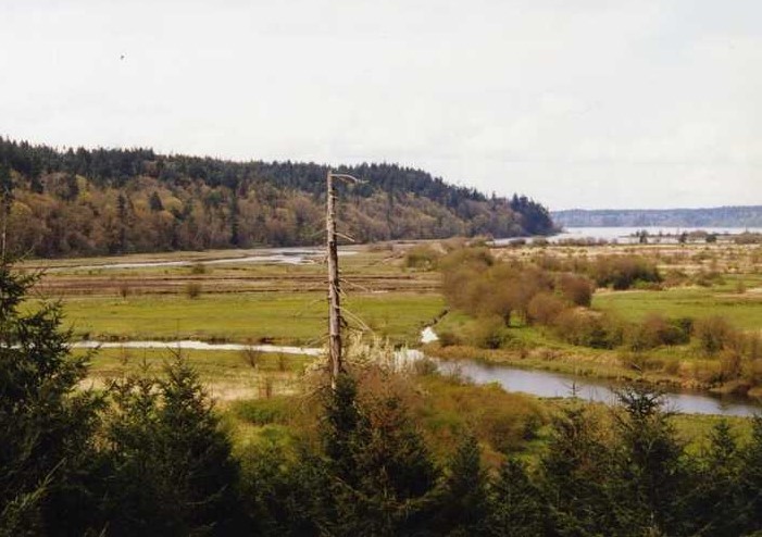
In response to the invitations, nearly 700 tribal members converged by horse and canoe at Medicine Creek on December 24. The creek (now generally known as McAllister Creek, although a small tributary retains the name Medicine Creek), runs through the west side of the Nisqually Delta about a mile west of the Nisqually River. The treaty council was held near a Nisqually village, in a low clearing bordered by tall fir and cedar trees long used as a meeting ground, about two miles from the creek's mouth (just north of where Interstate-5 now crosses the delta). Given the vast cultural and linguistic differences, it is unclear how the tribes interpreted the U.S. request to come sign a treaty ceding their lands -- in addition to very different political structures, the tribes had "no history of buying and selling land" (Harmon, 79). But ceremonial gatherings of different groups to feast, exchange gifts, and work out agreements were common in their culture, and Stevens and his team attempted to follow that pattern.
Festivities got underway when Stevens and the rest of his party arrived on the evening of the 24th (some had come the day before to prepare the site). Along with Gibbs, Simmons, and Shaw, American citizens present who would sign the treaty as witnesses included territorial officials; U.S. Army Lieutenant William Slaughter (1827-1855); and James McAllister, whose homestead was a short distance up the creek, and other settlers. They and the Native Americans greeted each other and feasted together before the treaty presentation began on Christmas morning.
Although two days were devoted to the process, and the treaty commission notes and subsequent statements by participants including Shaw assert the treaty provisions were read, thoroughly explained to, and understood by the Indian representatives, the overall record makes that unlikely. Stevens had Shaw read and explain the treaty only in the Chinook Jargon. With a vocabulary of only a few hundred words, the jargon, "[l]ike pidgin English ... was a rudimentary device for trade" (Wilkinson, 11), completely "inadequate to convey the complex issues of treaty making" ("History").
While the significance of permanently ceding their lands and many details spelled out in the treaty may not have been understood, tribal leaders were keenly aware of two key points: they were being asked to leave their homes and surrounding lands and move to three small areas designated as reservations (little Squaxin Island and small tracts near the Nisqually and Puyallup rivers), but were promised they could keep fishing and hunting where they always had. The primary source of contention, at and after the treaty council, was the size and location of the reservations. Surviving commission records do not show when Stevens and his team decided on the sites, but it was evidently at the last minute.
While official records assert no objections were raised, the overall historical record indicates that at the council and repeatedly thereafter many tribal leaders, notably Leschi, vehemently objected to the offered reservations. They had good reason. The reservations assigned the Nisqually and Puyallup, each just 1,280 acres, were located on rocky, thickly forested bluffs above the respective river deltas. Neither site provided access to river shorelines or bottomlands, and they completely lacked the open prairies that upriver villagers relied on for farming and pasturing horses. In multiple statements over the years, other Indians present reported that Leschi angrily rejected the offered reservation, telling Stevens his people needed bottomlands to farm, prairies for horse pasture, and land along the creek for canoe access to saltwater.
Despite those concerns, which many tribal members shared, on December 26, 1854, a portion of the 62 tribal signatories named placed their X-marks on the treaty, some feeling they had no alternative. But later Native accounts, even by those who acknowledged signing themselves, unanimously reported Leschi did not do so. Some also identified other listed signers who refused to sign. Once the treaty was signed, by however many did, Stevens and his team distributed presents to the Indian participants and the council concluded.
Stevens hurried off to make more treaties on Puget Sound -- three more were signed in January 1856 -- and the Medicine Creek Treaty was sent off to Washington, D.C., for ratification by Congress. But matters the treaty was supposed to resolve were far from settled.
Discontent, War, and New Reservations
Within weeks of the Medicine Creek council, Puyallup and Nisqually tribal members were reporting their unhappiness with the intended reservations to settlers, Hudson's Bay Company officials, and treaty commission members. And tensions mounted across the territory as Stevens induced most Western Washington tribes to enter treaties ceding their lands, and then proceeded across the mountains to obtain the land of Eastern Washington tribes. Many of them were also unhappy with their treaties, and that discontent increased when settlers began encroaching on their lands even before their treaties were ratified. Although Congress ratified the Medicine Creek treaty in March 1855, it would be several years before it approved the remaining Stevens treaties.
In September armed conflict broke out east of the mountains. Fighting spread to Puget Sound in October, after James McAllister claimed Leschi was seeking to unite Indians against settlers there. While scouting for a militia unit sent to apprehend Leschi, McAllister became one of the first casualties west of the mountains. Fighting in the west continued sporadically until spring 1856. By then local Indian forces had given up and returned home or retreated across the mountains.
But the conflict and resulting criticism, by many settlers and U.S. Army officials, of Stevens' inflexible approach to tribal concerns led the governor to provide better reservations. In August 1856 on Fox Island, where many Indians who had not joined the fighting were interned, Stevens met with tribal leaders including Puyallup Chief Squatahan and other signers of the Medicine Creek Treaty. There he offered what the Puyallup and Nisqually had sought -- larger reservations right on each river with "land enough for horses" (Tears of Internment, 34). The new Nisqually Reservation occupied 4,717 acres on both sides of the Nisqually River a few miles above its mouth, and the Puyallup covered more than 18,000 acres along the Commencement Bay shoreline and up the Puyallup River. Stevens also offered a new reservation along the White River, which became the Muckleshoot Reservation, to a group including Upper Puyallup, Duwamish, and other tribal members. All three reservations were proclaimed by President Franklin Pierce (1804-1869) on January 20, 1857.
Treaty Rights and Tribal Sovereignty
Neither the Puyallup nor the Nisqually reservation remained as proclaimed in 1857. Located on valuable waterfront adjoining fast-growing Tacoma, the Puyallup lands were increasingly coveted by non-Natives, who pushed to acquire them from Indian residents who received title to individual parcels under the allotment policy authorized in the treaty and later adopted nationally. By the 1930s, less than 100 acres were owned by tribal members. On the Nisqually Reservation, in the 1918 condemnation of land for Camp Lewis (now Joint Base Lewis-McChord [JBLM]), the U.S. Army took over all the land on the Pierce County side of the river, more than two thirds of the total.
Despite the loss of reservation land, the Medicine Creek Treaty and rights it guaranteed gained increasing importance in the lives of tribal members. Native Americans joined African Americans and other groups in the burgeoning civil-rights movement to demand rights long denied them -- with a critical distinction. While civil rights are personal to individuals, Native Americans also sought "group rights ... and they based their claim for group rights on their inherent sovereignty and the Treaties ... made with the United States" (Nation to Nation, 205).
Nisqually and Puyallup tribal members were central players in an iconic part of that treaty-rights struggle, the "fish wars." Since the early 1900s, as non-Natives took more of the catch and runs declined, Northwest tribes looked to courts to protect their fishing rights. While always recognizing the rights, decisions were inconsistent as to the extent states could restrict them in the name of conservation or otherwise. Pressed by non-Native recreational and commercial fishers, Washington officials frequently cracked down on Indian fishing. Nisqually Billy Frank Jr. (1931-2014) was arrested for the first of more than 50 times at age 14, and a 1954 arrest of Puyallup Robert Satiacum (1929-1991) led to an inconclusive state supreme court decision. By the 1960s, "fish-ins" were common along the Puyallup and Nisqually rivers, as Indian fishers and activists, sometimes joined by celebrity supporters, gathered to fish in defiance of state officials who responded with mass arrests.
The Nisqually, Puyallup, and Squaxin Island tribes were parties to the litigation that led in 1974 to the historic Boldt Decision, which "unequivocally reaffirmed ... treaty tribes' right to fish in their 'usual and accustomed places and stations' without restrictions" (unless necessary to preserve endangered runs), and additionally held "that the treaty language 'in common with all citizens of the Territory' meant the fisheries would be divided in half, with 50 percent of the annual harvest going to Indians tribes" (Ott). The ruling "elevated the tribes to the role of co-managers with state fisheries management agencies" and led them to establish the Northwest Indian Fisheries Commission to fulfill that role (Ott). The three Medicine Creek tribes were represented on the commission. Billy Frank Jr. served as commission chair for nearly 30 years.
Enforcement of treaty fishing rights was one example of an overall shift in federal policy in the later twentieth century. Both the executive branch and Congress dealt more often with tribes as the sovereign nations recognized in treaties, consulting them on matters affecting them and having them administer many federal programs on reservations. Tribes across the country negotiated settlements compensating them for lost lands. In 1990 the Puyallup Tribe received $162 million and 900 acres in what was then the second-largest land-claims settlement in U.S. history. On Nisqually Reservation land taken for JBLM, army and other federal officials worked with tribal members to establish a fish hatchery operated by the tribe, end maneuvers in sensitive riparian areas, and allow elders access for gathering traditional medicines and materials.
For all the flaws in its creation and implementation, in the twenty-first century many tribal members see the Medicine Creek Treaty as central to their history and future. When the original treaty document signed in 1854 was publicly displayed for the first time, in 2017 at the National Museum of the American Indian, a reporter wrote "[t]he Nisqually, Puyallup and Squaxin Island nations view those six handwritten pieces of paper as sacrosanct" (Ault).
A decade earlier, noting the passing of the Treaty Tree, a Douglas fir that helped shelter the Medicine Creek council and remained standing for 150 years until "most of what remained ... came crashing down during a storm ... this past December [2006]," Billy Frank Jr. wrote that the treaty "forever change[d] our lives" but "through the treaty we also kept some things to ourselves that were most important to us," adding "The Treaty Tree may have fallen, but the treaties are alive" ("Being Frank").
