In May 1855, Gustavus Sohon (1825-1903) documents important scenes at the Walla Walla treaty council conducted by Governor Isaac Stevens (1818-1862) and General Joel Palmer, the Superintendents of Indian Affairs for Washington Territory and Oregon Territory. Sohon also sketches portraits of key figures at the council, including members of the Cayuse, Nez Perce, Palus, Umatilla, Walla Walla, and Yakama tribes. Sohon arrived on the Columbia River in 1852 as a private in the U.S. Army, and during the following decade, accompanied four expeditions across Eastern Washington. A man of many talents, Sohon serves as a guide, an interpreter, an explorer, and a cartographer, but he is best known as a self-taught artist whose surviving pencil sketches and watercolors of important figures and landmarks comprise valuable eyewitness records of a crucial transitional period in Inland Northwest history.
Intelligent and Faithful
During the spring of 1855, Governor Isaac Stevens, in his role as Superintendent of Indian Affairs for Washington Territory (present-day Washington, Idaho, and western Montana), had completed treaties with the Western Washington tribes and was preparing to negotiate with the Columbia Plateau and Rocky Mountain tribes under his supervision. Accompanying the governor on his tour of the Inland Northwest was a soldier named Gustavus Sohon, “a very intelligent, faithful, and appreciative man … who had shown great taste as an artist, and ability to learn the Indian language” (Stevens, 12:196).
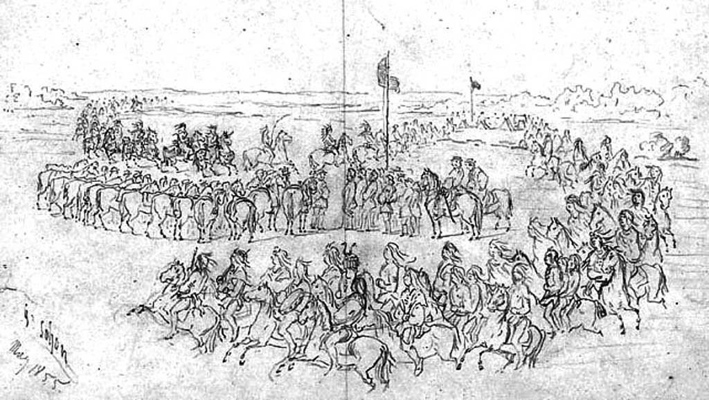
The first of the Eastern Washington treaty councils took place in the Walla Walla Valley. On May 24, 1855, in a dynamic pencil sketch, Sohon recorded the ceremonial arrival of hundreds of Nez Perce Indians and their reception by the American officials. “Soon their calvacade [sic] came in sight, a thousand warriors mounted on fine horses and riding at a gallop, two abreast. They halted while the head chief, Lawyer, and two other chiefs rode slowly forward, dismounted and shook hands with the commissioners” (H. Stevens, II: 35).
Documenting An Historic Event
The next day Sohon documented the goodwill feast served by Stevens and Palmer to an assemblage of Nez Perce chiefs under an arbor built to shelter the diners. A young lieutenant who visited the Nez Perce camp that same afternoon to pay his respects to Chief Lawyer wrote, “We found the old chief surrounded by his family and reading a portion of the New Testament, while a German soldier of Governor Stevens’ party was engaged taking his portrait in crayon. He afterwards presented me with a copy, which I keep as a memento of these pleasant days in the wilderness” (Kip, appendix).
Representatives from other Plateau tribes soon swelled the council, and over the next three weeks, Sohon was busy with pencil and pen. He rendered likenesses of tribal observers from the Spokane and Kettle Falls tribes, as well as many of the Cayuse, DesChutes, Nez Perce, Umatilla, Walla Walla, and Yakama leaders as they negotiated the future of their homelands. His pencil captured not only those chiefs who favored a treaty, but also its most vocal opponents. His sketchbook included the only known image of Kamiakin, drawn on June 7, the same day that the young Yakama chief, tormented by the choice before him, declined to speak to the council.
Stevens, Palmer, and the leaders of the attending tribes eventually reached a compromise, and by June 11, 1855, three separate treaties ceding almost 60,000 square miles of land had been signed. The only surviving images of this signal event are two Sohon sketches showing six young Nez Perce seated on the ground with pens, paper, and inkwell in hand. They are both labeled “Nez Perce Indians preparing the records of the Walla Walla Council June 1855.”
