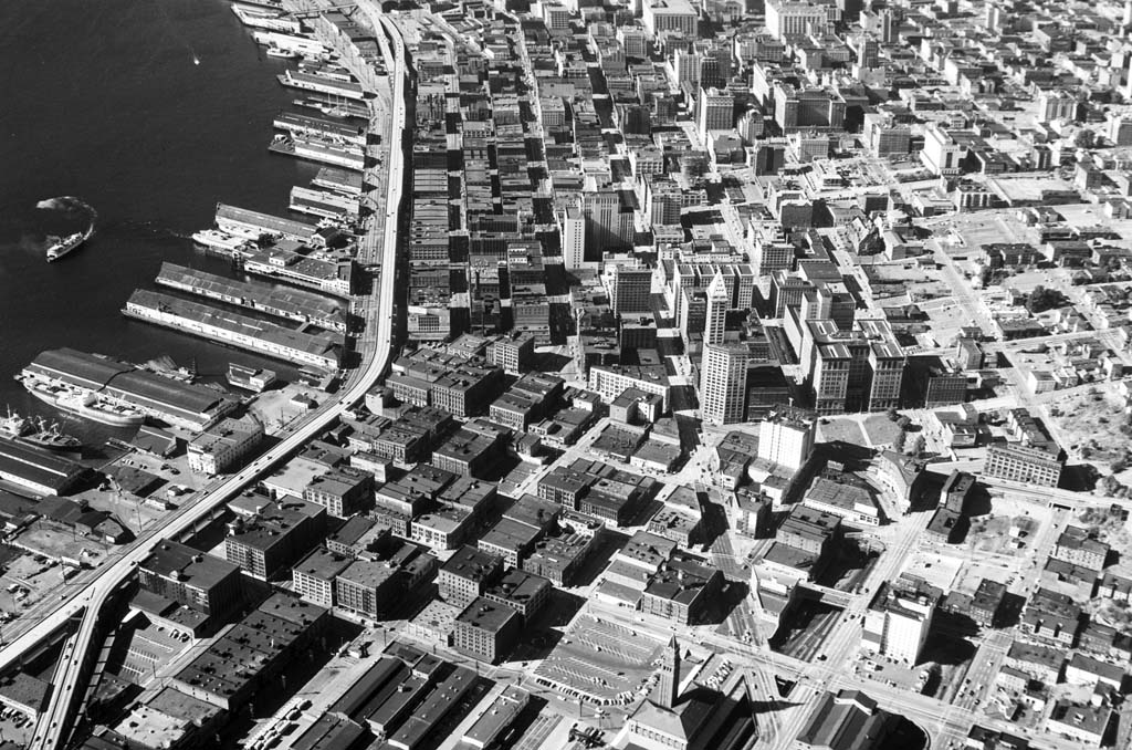
After a protracted planning period that spanned nearly two decades, work commenced on the Alaskan Way Viaduct on February 6, 1950. The project, jointly constructed by the City of Seattle and the state Department of Highways over 16 years, provided Seattle with its first bypass route around the downtown business district, relieving traffic congestion. When the Columbia Street on-ramp opened in 1966, the finished project included an elevated, double-deck highway, a subway under Battery Street connecting the viaduct to Aurora Avenue, eight ramp connections, two underpasses, and a southern, at-grade roadway that rose on another elevated structure to pass over the Spokane Street Viaduct and connect with E Marginal Way.
Building roads to serve the rapidly growing number of motor vehicles entered a new phase in the postwar era. After an initial burst of road building following the introduction of cars and trucks to Washington in the early twentieth century, the Great Depression and World War II delayed the larger infrastructure that the driving public demanded. The Alaskan Way Viaduct was part of a larger effort to develop the remaining two-lane segments of State Route 99, also known as Pacific Highway, into a four-lane roadway from the Oregon border to the Canadian border. Most of the existing four-lane roadway lay between Everett and Tacoma. The plans included converting 130 miles of the highway to four lanes and moving the highway along 79 of those miles to a straighter alignment that bypassed towns. Most of this realignment would be south of Olympia.
Dividing the Work
The initial viaduct and subway project was divided into five contracts. Schedule A covered the Battery Street Subway (traffic engineers used the term "subway" to refer to roadway under another street). Schedule B included side-by-side viaducts between Battery Street and Pike Street. Schedule C, the largest section, carried the double-decked viaduct between Pike and King streets. Schedule D, the smallest section, included a short segment of the viaduct and the on- and off-ramps to 1st Avenue S, which served as the terminus of the viaduct until 1959. Later work extended the viaduct to S Holgate Street, where the roadway returned to grade until it reached S Hanford Street and again became an elevated street to cross over the Spokane Street Viaduct and connect with E Marginal Way at the surface. A final contract for Schedule E covered lighting, emergency telephones, and signage on the Viaduct.
Work began on the north end of the viaduct structure, at Western Avenue and Battery Street. The city had already condemned and cleared the path for the construction work. Demolition crews took out a handful of small brick and wood-frame buildings, leaving any that did not lay in the path of the columns or roadway deck.
Crews from McRae Brothers, which had won the contract for Schedule B, began digging on February 6, 1950. They had planned to start in January, but a remarkably cold and snowy month delayed their start. Once the weather warmed up, however, muddy conditions led to a less than auspicious start. A power shovel got mired in mud up over its tracks and had to be hauled out with a crane, halting work for a day.
The side-by-side three-lane elevated roadways of Schedule B extended from what would be the opening of the Batter Street Subway, on the hillside below the intersection of 1st Avenue and Battery Street, to a point below the foot of Pike Street, where the structure would become a double-deck viaduct. Until the Battery Street Subway was completed, connecting the viaduct with Aurora Avenue below the intersection of 7th Avenue and Denny Way, northbound traffic on the Alaskan Way Viaduct exited the roadway at the ramp to Western Avenue and southbound traffic entered it from a ramp off Elliott Avenue.
A team of Department of Highways engineers supervised each phase of the viaduct and subway construction. They helped deal with unexpected situations. In the department newsletter, Frank Culp explained the types of situations that state engineers encountered on this, their first large-scale urban road project:
"1) lowering and bridging footings to accommodate railroad traffic, 2) notching footings to clear adjacent building footings, 3) substituting longitudinal cantilever retaining wall footings because pile drivers could not clear power lines above and miss a 12 inch sewer and 16 inch water main below, 4) finding underground pipes in the wrong place, not shown on the plans or abandoned, 5) supporting adjacent building footings which were above our footings, 6) clearing buildings by 2 inches or less with pile driver hammers, 7) trying to find working room amongst cars parked all over the place" (Culp, 5).
Unexpected Discoveries
During the pile driving, workers on the site came across a number of things that had been covered by fill when the Alaskan Way seawall was built in 1936. Culp mentions the "stacked slashings" from an old lumber mill, an obsolete brick seawall, and areas with 36 inches of stacked concrete slabs (Culp, 6). The pile drivers also found the concrete foundation platform for one of the hydraulic pumps used during the regrade of Denny Hill.
Not mentioned in the Department of Highways' newsletter articles is the notch in the viaduct railing at the Empire Laundry Building at Western Avenue and Bell Street. In condemnation maps prepared in 1948, it appears that the engineers planned to pass very close to the building, but not encroach upon it. When construction crews reached the corner of the building and realized they would need to pass through about a foot of a corner of the building, the engineers determined, with the approval of the Bureau of Public Roads, that they could cut a notch out of the viaduct's railing and curb to go around the building.
Before McRae Brothers completed Schedule B in July 1951, the state called for bids on Schedule C, the double-deck structure that stretched from Pike Street to King Street. Two contractors, Morrison-Knudsen Company of Boise, Idaho, and Rumsey and Company of Seattle, won the state contract for $3,691,400 and started work in early 1951.
The first step in preparing the space involved moving railroad tracks. Railroads had long dominated Seattle's waterfront. During the construction of the Alaskan Way seawall and Alaskan Way, a number of unused and underused tracks had been removed, but other tracks still occupied the center swath of the wide Alaskan Way right-of-way and spurs regularly crossed Alaskan Way to reach the piers. At the southern end of the central waterfront, tracks leading to railroad warehouses and a switching yard lay in the path of the new viaduct. The city agreed to pay half the cost of relocating tracks out of the viaduct's path, leaving a double set running between Alaskan Way and the viaduct's columns. Other tracks ran on the east side of the viaduct, serving some of the commission houses and other warehouses along Western Avenue.
The middle section of the viaduct, the longest at 4,095 feet, had the least complicating elements and grew up relatively quickly along the central waterfront. There were some complaints from local business owners when the construction crews needed to close two of the four lanes of traffic on Alaskan Way, but compared to the later coordination required for the Battery Street Subway, the project moved along easily.
Pile Driving
Morrison-Knudsen subcontracted with Raymond Concrete Pile Co., of Chicago, to drive the 2,500 pilings that support the central portion of the viaduct. Sixteen pilings for each of the columns were driven to the layer of compacted glacial till that underlay the beach layer. Pre-construction soil testing and studies had shown the engineers that they could achieve adequate stability with this piling depth, though it relied on the seawall on the eastern margin of Alaskan Way to retain the soil that surrounded the pilings above the beach layer of the waterfront.
Over the beach areas (between Western Avenue and Alaskan Way) that had been filled, crews drove steel pilings. In some places where circumstances made it difficult to drive the steel pilings, Raymond Concrete Pile Co. used patented pour-in-place concrete pilings. A row of wooden pilings supported the lower deck until the workers completed upper deck in each span between columns.
Using pilings over a backfilled beach presented another challenge. The seawall allowed seawater to infiltrate the filled area with each high tide. City Engineer Ralph Finke (1901-2003) wrote to William A. Bugge (1900-1992), director of the Department of Highways, that the city engineers had chosen steel sheet piling for the project partly because the steel would form a scale on its surface when exposed to seawater. The scale would protect the pilings' cores from further corrosion. He dismissed corrosion that had occurred on the seawall as the result of tidal action, not the mere contact with the seawater.
No two of the viaducts' spans (structures between the columns) are the same length because the columns had to be placed where they would not interfere with loading docks, buildings, and other surface operations. Because of the double-deck design, the columns had to be placed on the exterior of the structure, instead of directly below the upper deck. This increased the span and, thus, the required strength of extra large, two-inch-square supporting rebar in the concrete decks.
At Marion Street, a well-used overpass that carried pedestrians over the railroad tracks and Alaskan Way to the piers had to be moved and realigned to enable it to pass below the viaduct and over trains that traveled at ground level. Engineers modified the design of the viaduct span at the overpass location, removing girders and cantilevering the road deck to allow more room for the overpass. Engineers used the same design, with a cantilevered lower deck, at University Street, to allow a future pedestrian overpass to be installed there, if the need arose.
While the design worked well, when the time came to remove the overpass for modification and to reinstall it 12 feet to the south in July 1951, the owner of the T & P Building at the corner of Western Avenue and Marion Street filed suit to halt the project. The lawsuit alleged that the building's second-floor tenants, fronting the pedestrian viaduct that carried people from 1st Avenue to the overpass at Alaskan Way, were going to lose business while the overpass, on which about 5,000 people traveled each day, was out of service and that those businesses had not been compensated for that loss during the condemnation process. Lawyers for the city argued that because pedestrians could still reach the businesses via 1st Avenue, the businesses were still accessible and not due any compensation. A judge issued an injunction halting work on the project until the issue was decided. A short time later, according to the city's attorney John A. Logan, "Some workman who apparently hadn't heard about the show cause citation got out his jackhammer and punched a big hole in the viaduct deck, thus effectively closing it anyway" and work progressed ("Damages").
Giant Cranes
To load materials to the two deck levels, crews used two enormous Washington Whirly-type gantry cranes on rails alongside the viaduct. The cranes' legs straddled one set of the railroad tracks that paralleled the viaduct so that trains could pass underneath the cranes. As work progressed, work crews would move a thousand-foot section of rails further down the work site and move the cranes to the next unfinished section.
Bulges in the structure jutted out at Columbia, Seneca, Spring, and University streets to accommodate future ramps to and from the viaduct and their acceleration and deceleration lanes. Some city engineers wanted to leave the ramps unbuilt and keep the viaduct purely a bypass route. However, the Bureau of Public Roads (the precursor of the federal Department of Transportation), which partially funded the project, required that the roadway connect with downtown streets.
The city decided to wait to construct the ramps until the viaduct extended to the Spokane Street Viaduct in the south and underpasses had been built to replace traffic lights on Aurora Avenue at Mercer and Broad streets to the north of the Battery Street Subway, ensuring that traffic would flow smoothly and surface streets would not be overwhelmed at the temporary north and south terminuses of the viaduct.
A somewhat tongue-in-cheek article written for the state Department of Highways newsletter captures the engineers' attitude toward the new challenges faced during their first urban highway project. P. C. Leonard wrote in 1953, "After a couple deck [concrete] pours another unusual problem developed. The bums along the waterfront stole the curing blankets off the green [freshly poured] slabs. They would drag them off and use them for bedding" (Leonard, 6). Leonard also fussed about being constantly harassed for change in "dehorn country," dehorn being a slang term for homeless men (Leonard, 6-8).
Long the commercial, transportation, and cargo hub of the city, Seattle's central waterfront and adjacent Pioneer Square had begun to decline in the post-war years. Cargo handling had shifted to the north and south ends of the waterfront, where filled tide flats offered more room than the central waterfront and its narrow shelf of land between the hills and the bay. The business district had shifted north of Yesler Way, leaving Pioneer Square to rooming houses, residence hotels, and bars. Its down-and-out population and dilapidated appearance earned it the nickname "Skid Row."
A nationwide steel strike in the spring and summer of 1952 slowed work on Schedule C, which was nevertheless still completed early, in September 1952, and on Schedule D, which was completed about two months late, in March 1953. The four-month strike, between April and July, closed down steel mills until unions and steel manufacturers gained the wage and price increases they sought (the industry was subject to wartime price controls due to the Korean War).
McRae Brothers began work on Schedule D, the portion of the viaduct from King Street to Railroad Way and ramps to and from 1st Avenue, in late 1951. The curved ramps crossed over 1st Avenue S and Railroad Way, both heavily used streets. To accommodate traffic, the construction crews allowed just 20 hours for installing the steel framework for the on-ramp. Frank Culp credited the precise craftsmanship of Pacific Car and Foundry (today's PACCAR Inc.) with the successful installation of a "three span, skewed frame, 6 percent grade, curved at one end steel unit" (Culp, 6). Culp also described how electric trolley buses operating on 1st Avenue had to get up to enough speed when approaching the construction site that they could coast under the ramp. A worker would run behind the bus and reconnect the bus poles to the wires on the other side.
McRae Brothers completed work in March 1953. Progress had been delayed by the steel workers' strike and a hoisting engineers' strike. The state released the company from its contract for the last part of the work, the paving of the ramps, according to an article in The Seattle Times. Letters in the City of Seattle archives suggest that the state did so in order that the city could do the striping of the roadway and open the viaduct early.
Innovative Lighting
Work on Schedule E, the lighting, emergency telephone, and signage installation, began in late 1952. Northwest Engineering Electric Company of Seattle won the contract for $148,534. It installed mercury vapor lights on the upper deck and, to light the roadway beneath the viaduct, on the underside of the bottom deck.
For the lower deck, because of the 14-foot, 6-inch ceiling height, which limited the efficiency of mercury vapor lights, the company installed considerably more expensive, state-of-the-art fluorescent lights to the underside of the upper deck. It was the largest installation of General Electric Form 206 type fixtures, with 77 units. These seven-foot luminaires featured two innovations that improved their performance. The "Rapid Start" mechanism enabled them to light immediately instead of having to warm up like earlier models. This eliminated the annoying flicker often associated with fluorescent lighting. The second innovation, "Power Grooves," caused a 62 percent increase in lumens using the same amount of electricity.
Writing in the Department of Highways newsletter, engineer Bill Lee explained the benefits of these particular lights for the viaduct. He listed the rapid lighting and lack of flicker, as well as the creation of less glare and more uniform light than conventional fluorescent or mercury vapor lights. Additionally, the luminaires increased light output as temperatures decreased. As a result, at night and in inclement weather, the lights would be brighter, and, therefore, increase safety.
Northwest Engineering Electric also installed 14 emergency telephones, lighted directional signs, and two warning signs, one on the upper deck near the planned entrance to the Battery Street Subway and one at the northern entrance to the subway. The warning signs read "Subway Closed -- Detour" and would be activated by a subway tender if carbon monoxide concentrations exceeded four parts per 10,000 in the subway.
Grand Opening
On April 4, 1953, Mayor Allan Pomeroy (ca. 1907-1966), Seafair Queen Iris Adams, and D. K. MacDonald, president of the Automobile Club of Washington, opened the viaduct to traffic at a celebration featuring an orchestra, a Seattle Police Department color guard and drill team, dancing girls, and local dignitaries giving speeches. After the party, traffic could enter the viaduct at Elliott Avenue in the north and exit it at 1st Avenue S or enter at 1st Avenue S and exit at Western Avenue.
As work ended on the Schedule D segment of the viaduct, the state let the contract for the Battery Street Subway in September 1952. Morrison-Knudsen Co. and Rumsey and Company won the contract for the 2,134-foot tunnel that began below the intersection of 1st Avenue and Battery Street and ended below the intersection of Denny Way and 7th Avenue, connecting the viaduct with Aurora Avenue.
The subway, which is not a true tunnel because its ceiling is formed by the surface-level Battery Street, was built without federal funds because the Bureau of Public Roads would not approve the city's plans for ventilation and fire control. Instead of building a large duct work system with a separate, at-grade building to house the mechanical system for a forced draft system, the city's ventilation system relied on 72 fans to draw fresh air in from the sidewalk level on Battery Street and 15-foot vents to the roadway above that alternated between the two bores, or sides, along the length of the subway for exhausting the air. These mechanisms, along with the "pumping action" of vehicles moving through the structure, ensured fresh air for drivers. The vents, at the insistence of the Bureau of Public Roads, were placed in raised curbs in the center of Battery Street to prevent snow from blocking them and rain from flooding the subway. Only at curves in the subway and at intersections and alleys on the surface street did the vents lay flush with the street. The curbs proved to be a significant traffic hazard and were removed in 1954.
Another innovation of the Battery Street Subway was its fire suppression system, a dry-pipe, automatic deluge system. The pipes remained empty until sensors registered an increase in temperature, at which point the automatic system opened valves and the pipes filled with water for the sprinkler heads located along the ceiling in each tube. The Bureau of Public Roads objected not to the system's design, but to its excessiveness. City Engineer Ralph W. Finke argued repeatedly for the system, writing after the subway's construction that, "The fire which occurred in the Holland Tunnel in New York [in 1949], with the resulting damage to the tunnel, loss of vehicles, and potential loss of life from such a fire, were factors which led to this provision" (Finke, "Waterfront," 9). Finke also solicited opinions from the Bureau of Mines and the National Board of Fire Underwriters, both of which endorsed the system. The Bureau continued to oppose the system, arguing that the fire doors and fire extinguishers would be adequate.
In order to make a safe turning radius from the waterfront viaduct to the Battery Street alignment, the subway had to pass below the corner of the Paramount Film Exchange building on the northeast corner of the 1st and Battery intersection. The city tried first to have the building's owner, Samis Land Company, move the structure. Samis Land Company balked at doing so, arguing that the building movers who had testified at the condemnation hearing refused to move the building for the price they had testified it would cost. The city eventually purchased the building, remodeled the basement so the subway could pass alongside it, and then resold the building. When the roadway was laid, it was superelevated (slanted to one side) at this turn and the one at the north end of the subway.
Excavating the Subway
Because the subway passed under a number of heavily traveled downtown streets, construction crews had to work within more constraints than they had during the viaduct's construction. Unable to close more than two cross streets at a time, Morrison-Knudsen and Rumsey and Company dug trenches, bored holes for steel H pilings (the compacted, clay-like soil made it nearly impossible to drive pilings straight), then placed pilings with concrete slabs between them to provide support for the roof's concrete slabs (which would also be the base for the new street) and to prevent subsidence of the buildings and land that lay immediately adjacent to the project.
The construction crews then excavated a trench down the center of what would be the subway. On top of each of the three walls, the crews poured a "seat" onto which they placed the cement slabs that spanned the width of each bore. This created a two-lane street, to which they added railings, which could be opened to traffic while crews excavated dirt to the depth necessary for the subway.
Rainy weather made conditions in the excavated pit difficult. The Seattle Times reported that "Trucks wallow and lumber through the muck with a distinctly dinosaurian quality and a power shovel rumbles and growls as its giant mandibles wrench at the heavy wall of blue clay yet to be excavated " ("Crews"). To provide a solid, less slippery foundation for the workers and their equipment, bricks from the recently demolished Central School at 7th Avenue and Madison were placed along the bottom of the excavated pit. The bricks remained after the excavation work was completed to underlay the new road.
In the project contract, the state required the contractors to carry 43,000 cubic yards of the excavated soil to Westlake Avenue, on the west side of Lake Union. At the northerly end of the lake, part of Westlake Avenue still spanned low shoreline areas on a trestle, as did the adjacent Northern Pacific Railway tracks. The excavated soil filled two elevated areas to the east margin of the street.
The contract also required that the contractors find a dumping site for the remaining 57,000 cubic yards of soil that would be removed. From records in the city archives, it appears that Morrison-Knudsen and Rumsey and Company chose the shoreline at Pier 89 (where the Amgen Building is located today). It was Great Northern Railway land, but Ralph Finke wrote to the state Department of Fisheries:
"In conjunction with construction of the Battery Street Subway portion of the Alaskan Way Viaduct, there will be about 60,000 cubic yards of waste excavation. The most logical waste site for this material is along Alaskan Way north of the present sea wall which ends at Bay Street. Dumping of dirt will cause some roiliness of the water in this vicinity.
"It would appear to us that this location is sufficiently removed from any fishing or spawning grounds so that it would not be objectionable" (Finke to Fisheries).
There is no record of the Department of Fisheries response, but it was likely in agreement, because filling moved forward.
Aurora Connection
When the Battery Street Subway opened on July 24, 1954, it connected viaduct traffic to Aurora Avenue, which had been widened to allow for an exit to Denny Way and an entrance from Battery Street. Just above the subway portal, surface portions of the subway (the fans and vents) cut across the block bordered by 6th and 7th avenues and Battery and Wall streets. The 60-foot wide swath of city-owned right-of-way left two small triangular lots, still privately owned and only minimally developed.
Ralph Finke recommended to the city council that the additional triangles be purchased and developed into a small park. In his letter to the council, Finke wrote, "These small green spots are not to be confused with large recreational parks, since they serve entirely different purposes. First, but perhaps not most important, they break the severity of the concrete, brick and steel of which our downtown areas are composed and add a touch of green and growing things. Secondly, and I think most important, they afford a spot for those who work or shop nearby to stop and sit awhile and rest, and perhaps even to think a little" (Finke to City Council). The council does not appear to have acted on the suggestion, instead turning the right-of-way into a street. The lots in question are the site (in 2011) of the Pink Elephant Car Wash and a parking lot.
While the bypass at the northern end of downtown was nearly complete (two intersections on Aurora Avenue, at Mercer and Broad streets, still slowed traffic), on the southern end, at Railroad Way and 1st Avenue S, the streets remained congested and the situation unsatisfactory. Drivers headed to and from the south end of the city had to navigate Seattle's industrial district with its freight truck and train traffic.
Much of the post-war funds that paid for the first phase of viaduct construction had been spent and the state budget did not have money readily available for extending the viaduct south to Spokane Street, where it could merge into E Marginal Way. The project progressed for more than a decade in bits and pieces, as funding from city and state budgets allowed.
In 1956 Rumsey and Company constructed an additional two-tenths of a mile of the viaduct, taking it to Connecticut Street (today's Royal Brougham Way). This portion remained closed to traffic until the entire roadway could be built to Spokane Street.
Southern Extension
Though the Port of Seattle and the railroads wanted an elevated structure to extend all the way to Spokane Street, that option proved too expensive and plans were made to build a surface street from S Holgate Street to S Hanford Street. Before further construction could go forward, the railroad tracks laying in its path, parallel to Alaskan Way S, had to be moved. Of the street's 250-foot right-of-way, 208 feet were covered with railroad tracks. Additionally a rail yard occupied a section of land near Spokane Street. After considerable negotiations, particularly over the price the railroads would pay for a tract of City Light land that had been the Seattle-Tacoma interurban right-of-way, agreements were signed with the Chicago, Milwaukee, St. Paul & Pacific, the Great Northern, the Northern Pacific, the Pacific Coast, and the Union Pacific railroads and the work of moving the tracks commenced.
A series of contracts carried the double-deck viaduct south to S Holgate Street where it became an at-grade roadway to S Hanford Street. At S Hanford Street it again became an elevated street to pass over the Spokane Street Viaduct and connect, back at grade, with E Marginal Way.
South of King Street, the elevated portion rested on a different type of pilings than the rest of the viaduct. The state Department of Highways designed the southern extension, as the portion south of King Street was known, and called for construction crews to drive timber pilings below the ground water line, chamfer (create a tapered edge) the end of the piling and then drive a 40- to 50-foot steel pipe piling onto the end. This pipe piling was then filled with concrete. The state used same method for the overpass over the Spokane Street Viaduct.
The southern extension opened on September 3, 1959. The viaduct extension to S Holgate Street and the at-grade roadway to S Hanford Street had been completed the previous year, but the opening awaited the construction of an overpass at the Spokane Street Viaduct. Opening ceremonies were held on the Spokane Street Viaduct overpass. A band, speakers, and Seafair Queen Diane Gray participated in the festivities. The ceremonial first car, a 1908 Buick convertible, drove through a large newspaper page and headed north on the extension and viaduct with six more antique cars following in its path.
Ramps and Underpasses
The roadway's connection with E Marginal Way meant that traffic could travel from the recently rebuilt 1st Avenue S Bridge and other routes into the city to Aurora Avenue on the expressway. Traffic could not, however, enter or exit from the Spokane Street Viaduct, requiring travelers to and from West Seattle to use city streets to loop around to E Marginal Way in order to reach the highway.
Another nationwide steel workers strike and a local machinists strike delayed the arrival of steel for the ramps and a strike of heavy-equipment operators slowed work. The off-ramp to Spokane Street from the southbound lanes of the extension opened on October 23, 1959, and the on-ramp from the east-bound lanes opened the next January. Both were built by Seattle-based Alton V. Phillips Company.
The state had assumed the funding of the southern extension in return for the city funding and constructing underpasses at Mercer and Broad streets. The diagonal route of Broad Street created a triangle of intersections several blocks north of the north portal of the Battery Street Subway. Moving traffic through the tightly-spaced intersections slowed traffic on the otherwise traffic-light-free viaduct and expressway extending from about 74th Street N near Green Lake south all the way to E Marginal Way.
To solve the tangled situation, the city contracted with Butler Construction and Engineering, of Seattle, to build an underpass for Mercer Street to pass under Aurora Avenue and another underpass that carried Broad Street under both Mercer Street and Aurora Avenue. The new streets opened in July 1958.
The city and state delayed construction of the final components of the viaduct project, ramps between the viaduct and downtown Seattle streets, until the roadway extended to E Marginal Way and the underpasses at Mercer and Broad freed the route from bottlenecks on city streets.
Traffic from the north end already had easy access to downtown Seattle via Aurora Avenue. Drivers could exit at Denny Way to reach downtown destinations. From the south, particularly for drivers from West Seattle, the only exit, at Western Avenue, took drivers north of downtown. To remedy this situation, the city planned to build a northbound off-ramp at Seneca Street and a southbound on-ramp at Columbia Street. The ramps at Spring and Union streets that would primarily benefit southbound travelers, though still planned, would await further funding.
Exit at Seneca
The city began the Seneca Street off-ramp in 1961. Built by Willar Construction Company, of Seattle, with city funding, the ramp began at one of the bulges on the upper, northbound, deck to the south of Seneca Street. It curved toward 1st Avenue, resting on a single row of columns in the sidewalk and roadway as it descended to street level.
The project encountered some difficulties with driving the pilings for the columns because of significant amounts of debris in the filled land under Seneca Street, which had been covered with elevated structures and streets for several decades prior to the filling that followed the construction of the seawall. At one point workers found railroad ties, a remnant of an abandoned rail line, encased in concrete, buried 24 to 36 inches underground.
While not an obstacle to construction, the city street configuration at 1st Avenue and Seneca Street caused some consternation. Seattle had adopted a one-way-street system in 1955 to make more efficient use of downtown streets. While 1st Avenue remained two-way, Seneca Street had become a westbound-only street. As a result, traffic exiting the viaduct had to turn left or right onto 1st Avenue, rather than go straight east on Seneca.
That arrangement remained in place, despite Mrs. R. S. Wise's plea in a 1961 letter in which she implored the city, "Please rearrange the Seattle Streets so when they get off on Seneca they go directly East. If you don't Seattle will be laughed at by all visitors [and] they will take that story back home" (Wise). While the street configuration was unusual, it did not cause undue backups or confusion. There is no record of whether it led visitors to laugh at Seattle.
The Final Construction
The city council funded the Columbia Street on-ramp in September 1964 and it was completed by Will Construction Company of Seattle in February 1966. The ramp began on 1st Avenue and rose along Columbia Street, swinging out to the north to allow sufficient space for vehicle acceleration, and entered the viaduct at a bulge on the lower, southbound, deck south of Columbia Street. This ramp could be accessed from westbound Columbia Street or either direction of 1st Avenue.
The Columbia Street ramp is the only part of the viaduct with solid railings. This is because the ramp passes very close to the building at the corner of Western and Columbia. Monte Brown (ca. 1915-1999), editor of the Daily Journal of Commerce, one of the occupants of the building, realized that the roadway would pass within feet of the newspaper office windows, blocking the view and bringing traffic noise into the office. He wrote to the City Engineer to ask if the ramp could be moved to the north side of the street. He was concerned that newspaper staff taking calls from government officials placing advertisements for calls for bids and attorneys placing notices, which had to be exactly correct, would be hindered in their jobs. However, Monte wrote, "since we always felt the Journal of Commerce is in some degree a part of City government, we would naturally support any decisions made by your department regardless of how it affected us" (Brown to Morse, February 17, 1964).
While the ramp could not be moved, the city did build a solid railing. Monte reported to City Engineer Roy W. Morse (1906-2002) "It turns out the only real annoyance, and this we can live with, is the obstruction of view since it is so close to our office windows. The dust and dirt, so far at least, isn't bad. Your suggestion of using sound proofing was certainly a good one as we have installed sound proof windows and acoustical material which blocks out traffic about 95 percent" (Brown to Morse, March 23, 1966).
The ramp opened on February 1, 1966, and, because the remaining planned ramps were never built, it marked the end of construction on the viaduct. The highway eased traffic congestion in downtown Seattle and provided easier access to downtown from West Seattle and north end neighborhoods. It also fundamentally changed the nature of the waterfront. City officials and citizens alike would spend the next several decades working with it and around it as they tried to create a vibrant, livable neighborhood.
To go to Part 4, click "Next Feature," to see Part 2, click "Previous Feature"
