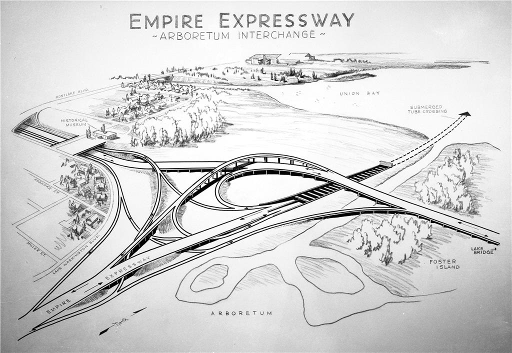
On March 8, 1959, Washington State Legislature removes two blocks of Lake Washington shorelands, later known informally as the WSDOT Peninsula, from the Washington Park Arboretum for state highway use. As work progresses on the Seattle Freeway (Interstate 5), the State Highway Department begins planning for a second bridge across Lake Washington and a connection between the freeway and an expressway the city plans to build along the east side of Capitol Hill between Empire Way (now Martin Luther King Jr. Way) and the Meadowbrook neighborhood in northeast Seattle. One interchange for this network of roadways is planned for the marshy area along the north margin of the Washington Park Arboretum. While planning for the expressway named for former city engineer R. H. Thomson (1856-1949), proceeds, the state Highway Department decides, against the city's wishes, to locate a second Lake Washington bridge between Evergreen Point and the Montlake neighborhood. Ramps between the highway and expressway are built across the marsh. When the Seattle City Council cancels the R. H. Thomson Expressway project in 1971, three incomplete ramps are left in place but unconnected to any roadway. Current (2012) plans for the replacement Governor Albert D. Rosellini Bridge (also known as the State Route 520 bridge and the Evergreen Point Floating Bridge) call for the removal of the ramps over the peninsula.
Washington Park Arboretum
The northern portion of the Washington Park Arboretum consists of land exposed when the level of Lake Washington dropped 8.8 feet after the Lake Washington Ship canal opened in 1916. The land was not immediately put to use. The Miller Street Dump, a city landfill, occupied a large site in the shoreline area from the late 1910s until 1936. In 1939, the state legislature granted the shorelands adjacent to Washington Park to the University of Washington for use as part of the arboretum it was developing in the park.
The Washington Park Arboretum, designed by the Olmsted Brothers landscape architecture firm in 1936, encompassed most of the existing Washington Park and included land in a canal reserve set aside in 1900 for the Lake Washington Ship Canal, but not used. James Frederick Dawson (1874-1941), the Olmsted Brothers landscape architect who came to Seattle to create a design for the arboretum, planned to shape the north end marshlands into a series of lagoons. The dredge spoils generated by that construction work would be piled on the adjacent land, raising it farther above the water line. Dawson planned to use the space for an expansion of the arboretum's planned alpine collection. The lagoons could be developed into water gardens and views of water would be brought into the arboretum, something the Olmsted Brothers' 1904 preliminary plan for the park had envisioned. The lagoons proved expensive to create and they did not reach very close to the area around the Miller Street Dump. It remained a broad, marshy peninsula extending out into Lake Washington.
Ramps to Nowhere
Plans for an "Empire Way" expressway along the eastern border of the park were underway as early as 1930, but did not progress very far until the 1950s, when the city engineer began developing plans for the route between the end of Empire Way in south Seattle (today's Martin Luther King Jr. Way South) at Rainier Avenue S and the Meadowbrook neighborhood in northeast Seattle. A 1958 map in the city archives shows the route of the proposed four-lane expressway along the east side of Capitol Hill, roughly following a route between 28th Avenue E (Martin Luther King Jr. Way) and 29th Avenue E south of the ship canal and 24th and 25th avenues north of the canal. A tunnel would carry traffic under the ship canal.
The state envisioned a connection between this planned expressway and the Seattle Freeway, as Interstate 5 was then known. To that end, the highway department planned an interchange in the Roanoke neighborhood to connect with a roadway across the shoulder of Capitol Hill and across a bridge over Portage Bay to the Montlake neighborhood. An interchange on the Arboretum land would carry traffic between this new road and the planned expressway and, potentially, a new bridge across Lake Washington.
The federal government, which was funding a significant portion of the construction costs for the new Seattle Freeway, required that the city build a second Lake Washington bridge. The city wanted the bridge built alongside the existing Lake Washington Floating Bridge that crossed the south end of the lake. The state and federal agencies wanted to build the bridge farther north, and the Montlake neighborhood offered an attractive location for it. Unlike at the southern bridge location, the state would not have to tunnel through a hill to reach the lake from the freeway. Also, just south of the Lake Washington Ship Canal, the canal reserve purchased by King County in the late 1890s but unused, offered a relatively undeveloped strip of land across the Montlake Portage area. The federal government owned part of the reserve and the city and county owned most of the rest.
On March 8, 1959, the state legislature passed legislation removing the two blocks from the Washington Park Arboretum it had given to the University of Washington in 1939. The land included the marshy area that contained the Miller Street Landfill site. The Arboretum lost about 60 acres of land due to the project.
In planning for the construction of the ramps, it became clear that the marshy shore lands would not support the weight of the heavy machinery needed to build the elevated ramps across the arboretum. The existing waterways and lagoons did not extend close enough to the building sites to allow crews to float in machinery and materials. To solve the dilemma, the Highway Department dredged a waterway on either side of the landfill site and dumped the dredge spoils near 26th Avenue E.
This dredging isolated a finger of land extending out into the lake that became known as the WSDOT Peninsula. The Seattle City Council cancelled the R. H. Thomson Expressway project in 1971 and ramp construction was stopped in various stages of development. Two ramps connected to the new bridge across Lake Washington that opened in 1963, but the ones intended for the expressway have remained in place but incomplete and unused for 50 years. Current (2012) plans for the new Governor Albert D. Rosellini Bridge (also known as the Evergreen Point Floating Bridge and the SR 520 bridge) include the removal of the all the ramps across the WSDOT peninsula.
