One of Washington's first cross-state highways, the Sunset Highway provided the first automobile route over the Cascade Mountains, a range that divides the state from north to south. When it opened in 1915, the highway largely followed the route of an Indian trail that had been developed into a wagon road. The Sunset Highway changed designations a number of times over the years, beginning as State Road No. 2, then becoming, sometimes in succession and sometimes simultaneously, the Sunset Highway, Primary State Highway No. 2, U.S. 10, and Interstate 90. The route serves as the primary east-west route in Washington, carrying traffic over the busiest mountain crossing in the state.
Trade Route
Snoqualmie Pass, the lowest of the state's cross-Cascade passes at 3,022 feet, has long served as a conduit for people and goods between the east and west sides of the mountains. Native communities, including the Yakama, Klickitat, Snoqualmie, various bands that would later be known as the Muckleshoot, and others, walked and, after the 1730s, rode horses over a number of mountain passes to trade and socialize.
The trans-Cascade trade relations were part of a larger regional network that stretched south to the American Southwest, east to the Great Plains, and north to what would become Alaska. Items that moved through the trade networks included dentalia (shells used as currency) and dogfish oil from the coast, obsidian from the mountains, bison robes from the Plains, and horses from the horse-raising tribes of the Columbia River Plateau.
When the Hudson's Bay Company established posts in what is now Western Washington in the 1830s, they brought cattle raised on the shrub steppe east of the mountains over Snoqualmie Pass. With the help of local Indians who knew the pass, they drove cattle to Fort Nisqually on Puget Sound.
Emigrant Trail
Early emigrants from the United States in the 1840s (the Northwest was still legally owned by Indian tribes and the British and American governments had agreed to joint occupation in 1818) followed wagon trails into the Northwest that led to the Willamette Valley in today's Oregon via the Columbia River Gorge. As that valley began to fill with farms, some settlers turned north to the Cowlitz Prairie and Puget Sound. It was an arduous trip, however, and settlers at Olympia and Steilacoom pled with the federal government to develop a road over the Cascades to Puget Sound.
As the trickle of settlers into Oregon turned into a flood in the 1850s, the sense of urgency for developing a road for emigrants across the mountains increased. In 1853, John Edgar, Whitfield Kirtley, Edward J. Allen, and George Shazer (ca. 1820-?) explored a route through Naches Pass that had been followed by the United States Exploring Expedition in 1841. The federal government appropriated $20,000 that year for a road, but it appears that the money was not ever spent. Instead, local residents gathered donations and contributed their own labor to the effort. The Columbian newspaper in Olympia exhorted its readers to support the building of the road because:
"Late advices from the States say, 'an immense throng will cross the plains this year,' — and our word for it, many thousands will come to Washington, if they can get here. It is our duty to them, to our country and to ourselves to open the way. Let us not by an unjustifiable, aye criminal, inertness neglect to do everything in our power."
"The realization of our greatest hopes depend upon the construction of the road from Walla-walla to Puget Sound" ("Road Over the Cascade Mountains").
In October 1853 the Longmire wagon train came through Naches Pass. One particularly difficult spot, which required lowering the wagons down a precipice by rope and spliced-together strips of cowhide from several of the wagon train's cattle, marred the crossing, but the entire group made it through and would be followed by others.
Looking for a Better Route
Meanwhile, efforts to find another, easier route for wagons and anticipated railroad trains continued. Army Captain George McClellan (1826-1885), Lieutenant Abiel Tinkham (ca. 1824-1871), and Seattle businessmen Dexter Horton (1825-1904) and Carson Boren (1824-1912) all tried to survey routes through Snoqualmie Pass in the 1850s. Several mistakenly took the higher Yakima Pass just south of Snoqualmie and were stymied by the difficult crossing. National disputes that would lead to the Civil War and local conflicts over treaties between Indian tribes and the federal government slowed efforts to develop a trans-mountain route.
Gold found in 1858 in the Fraser River in what would become British Columbia spurred use of the Snoqualmie Pass trail. Miners on foot and horseback followed the route inland to meet up with an overland trail to the Fraser River.
A decade later, Seattleites again sought to develop a wagon road over the pass. A more direct connection to Walla Walla would afford Seattle businesses access to the economic and transportation hub of the interior. The Mullan Road reached from Walla Walla into the mining districts in what would become Idaho and Montana. Additionally, the Oregon Trail passed near Walla Walla and numerous emigrants stopped there for provisions.
Arthur A. Denny (1822-1899) later claimed in his memoir that in 1865 he, Jeremiah Borst (1830-1890), and William Perkins consulted with Saniwa, a Klickitat man, about the route over Snoqualmie Pass. Saniwa instructed two younger men from his tribe and they led the Seattle party through the pass. Denny claimed that they left the Indian trail at the summit and followed an alternate route along Lake Keechelus, though the reason for this is not clear.
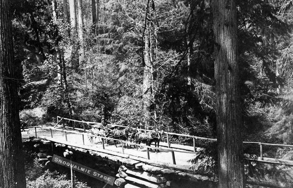
Building a Wagon Road
King County and local residents contributed money that fall and a crew worked on a road from Ranger's Prairie (later North Bend) to Lake Keechelus, a long narrow mountain lake running roughly south from just east of the pass, from which the Yakima River flows southeast toward the Columbia. Work resumed again in the summer of 1867, with a road opened to the south end of Lake Keechelus that year. Wagon train emigrants used the route to reach Seattle. Beginning at Walla Walla, they followed the Walla Walla, Columbia, and Yakima rivers to the summit of Snoqualmie Pass.
Though Denny wrote that the road led to the south end of the lake, other sources describe how the emigrants built rafts out of timber found around the lake and floated their wagons and passengers to the north end (livestock had to swim), where they unloaded and followed the trail westward. Possibly, the emigrants used the rafts when the water was high or the snow deep and followed a lakeshore trail during low water in the late summer and early fall.
From Snoqualmie Pass, the trail descended via the South Fork Snoqualmie River valley to about where Issaquah is today. From there the wagon road took travelers around Cougar Mountain and into the area that would become Renton, and then connected to the Steilacoom-to-Seattle military road.
Travelers, Traders, Miners, and Livestock
Travelers crossed the pass in both directions. Eastern Washington offered abundant rangeland that could be claimed under the Homestead Act of 1862. In 1868, early settlers Charles Splawn (1831-1908) and Dulcina Thorp Splawn (1844-1869) and Tillman Houser (1840-1918) and Louise Houser (1843-1916) moved east over the pass. In 1870, A. J. Splawn and Ben Burch established the Robber's Roost trading post on the Yakima River, at the future site of Ellensburg. In 1871, Splawn sold the store to John Shoudy (1842-1901) and his wife Mary Ellen (1846-1921). John Shoudy used the trail to carry goods for his store.
Miners used the trail to get to mineral-rich areas on the east side of the Cascades, but by far the most common sight along the road was livestock. Farmers raised cattle, sheep, pigs, and horses on the range east of the mountains, as far east and south as Idaho and Oregon, then drove them to markets on the west side via Snoqualmie Pass. In 1883, Ellensburg newspaper The Kittitas Standard valued the livestock crossing the pass at $500,000 per year. Even accounting for the inflationary tendency of newspapers at that time, a large number of animals went to market over the pass.
In a memorial to Congress seeking funding for improving the Snoqualmie Pass road in 1881, the Washington legislature listed a number of reasons for doing so, including the need for Eastern Washington agriculture products (primarily livestock) to support the population in Western Washington. Additionally, farmers in Eastern Washington would have better access to Puget Sound ports. The new road would also allow for more reliable and faster mail service. In general, a road across Snoqualmie Pass would, according to the legislature, promote Washington Territory's development as a whole.
Seattle and Walla Walla Trail and Wagon Road Company
Congress was not moved to appropriate funding and, as demand for a better road that could handle the larger freight wagons grew, in 1883 a group of investors incorporated the Seattle and Walla Walla Trail and Wagon Road Company to develop a toll road. A group of investors, including Walter A. Bull (1838-1898), Nathan W. Preston (1854-1933), and Henry M. Bryant (1841?-1919), incorporated the toll road company and proposed to build and maintain the road from Taneum Creek near Ellensburg to the Snoqualmie Plain near the summit. At either end it would meet up with existing trails (down the west slope of the Cascades via the South Fork Snoqualmie River valley and southeast to Walla Walla through the Yakima River valley). The Kittitas County Board of Commissioners awarded the road franchise to the company in 1884.
The road was built, but fell short of expectations for its owners. Travelers evaded paying the toll and in 1888 the Northern Pacific Railway brought its rail line through Stampede Pass, just south of Snoqualmie and Yakima passes. The railroad ran through Spokane, Pasco, Yakima, and Ellensburg and provided a reliable way of transporting people and goods over the mountains. Walla Walla began to lose its regional importance and efforts to improve the route over Snoqualmie Pass slowed.
About a decade later, in 1899, the state and King and Kittitas counties appropriated funds and let a contract to David Denny (1832-1903) to repair the existing road. Denny, who knew the area well because he had worked mining claims in the area, repaired river crossings, cleared debris from the road, and built bridges, but was not able to get the road fully into shape with the amount allotted. From the report he made, it appears that the river crossings posed the greatest difficulties. The trail crossed the Snoqualmie and Yakima rivers a number of times in order to follow the most favorable grades along the hillsides but the flowing water often wrecked improvements.
Though the road was in miserable condition, Denny remarked upon the amount of traffic he saw on it that summer. About 200 wagons and carriages crossed over the pass, along with 1,148 horses. Some were settlers from the East Coast and Midwest, the tail end of the wagon trains that had traveled west along the Oregon Trail for more than 50 years.
Autos Appear
Not long after Denny finished his work on Snoqualmie Pass, automobiles began appearing in the Northwest, along with increasing demand for better roads. The first cars over Snoqualmie Pass traversed the summit in 1905. Bert Harrison Sr. and Tom Hazelfield of Ilwaco drove an 1898 Frayer-Miller from Indianapolis to Seattle, and Charles L. Ray of the Automobile Club of King County and John Kelleher of Ellensburg drove a Winston over the pass from Seattle to Ellensburg. Each vehicle took several days to cross the pass because of the rough road.
That same year, the state legislature established a Highway Department, which worked with counties to develop a state road system. Work began in 1907 on State Road No. 7, the precursor to the Sunset Highway, between Easton, east of Snoqualmie Pass, and North Bend to the west. State Road No. 7 was the first trans-mountain state highway built because of Snoqualmie Pass's relatively low elevation and because the grades approaching it were more gradual than at other passes.
The 1907 legislature, spurred on by plans to hold the Alaska-Yukon-Pacific Exposition in Seattle in 1909, appropriated $30,000 for clearing, grading, and building bridges on the pass. While most people would travel to the world's fair on trains and steamships, organizers anticipated that some visitors would come by automobile and they did not want the drivers to be routed through Portland via the Columbia Gorge (the only other Cascades crossing at the time), thereby emphasizing Seattle's remoteness. To prepare the road over the pass, crews blasted rock and cleared a route along the eastern shore of Lake Keechelus, built a bridge across the Kachess River, and cleared trees and rocks from the road.
Additionally, fair organizers helped plan a transcontinental automobile race from New York to Seattle. With the firing of a starting gun at the exact moment the fair opened in Seattle, the race began. Two Ford Model Ts, a Shawmut, an Itala, and an Acme followed the maze of roads, many of them unmarked and unmapped, across the country. When they reached Eastern Washington, all but the Itala (which crossed the mountains on a rail car) followed the Snoqualmie Pass route over the mountains and down into Seattle. When they arrived in Seattle, the drivers looked as though they had been painted with mud and the Shawmut's team named the Snoqualmie Pass portion of the race "the worst road we encountered along the whole trip" ("Snoqualmie Pass Worst"). In addition to the racing cars, 105 automobiles crossed the pass that summer and fall.
Planning Highways
Roadwork continued over the ensuing years, with annual closings for snow in the winter and clean-ups in spring. In May 1912, the Good Roads Association, a private group of road development boosters, recommended three trunk highways be built across the state to provide access for automobiles to all areas and to improve economic development: the Pacific Highway, spanning the state from north to south on the west side of the mountains; the Inland Empire Highway, crossing the agricultural lands between Ellensburg and Spokane via Yakima and Walla Walla; and the Sunset Highway, traversing the midsection of the state between Spokane and Seattle via Wenatchee and Ellensburg.
The same year, the Highway Department's biennial report included a discussion of the three trunk highways. The report recommended the completion of at least one east-west road in anticipation of the opening of the Panama Canal, expected in 1914. Northwesterners hoped that the drastically shortened sea route to the East Coast and Europe would increase demand for local agricultural and industrial products and natural resources. The Highway Department report advised the legislature to appropriate funds for the Snoqualmie Pass road first because it offered the greatest good for the most people in the state as it would pass through the most populous and productive parts of the state.
The Automobile Club of Seattle supported the development of the Sunset Highway in 1913, in anticipation of attracting increased traffic due to the opening of the Panama-Pacific Exposition in San Francisco in 1915. As with the Alaska-Yukon-Pacific Exposition, boosters envisioned that at least some visitors to the fair would take advantage of the improved cross-country roads and travel west to Washington and then south along the Pacific Highway, which was sufficiently complete to carry travelers to California.
The Sunset Highway
When the Sunset Highway officially opened in July 1915, it traveled a different route than the one envisioned by the early road builders on the pass. After construction of the Northern Pacific Railway in the 1880s bypassed Walla Walla, Spokane surpassed Walla Walla as the principal city of the Inland Empire, as the area drained by the Columbia River was known.
Instead of running southeast toward Walla Walla by following the Yakima River Valley to the Columbia River, the Sunset Highway turned northeast just past Cle Elum to cross Blewett Pass and then dropped down the Peshastin Creek valley to Wenatchee. There the highway crossed the Columbia at the only automobile bridge over the river in the state (other crossings were made via ferries). The state had to purchase the bridge from the Wenatchee Bridge Company, which had built it to carry traffic and an irrigation pipe across the river to orchards on the east side. The highway continued north along the Columbia for a short distance and then turned east at Orondo to Waterville, Davenport, and Spokane.
For a short time state officials had considered routing the Sunset Highway down the Yakima River valley as far as Ellensburg, then east to Vantage on the Columbia River. A bridge had not yet been built at Vantage, however, so traffic would have had to cross the river by ferry or travel through Colockum Pass to Wenatchee. Residents of eastern Kittitas County wanted the Colockum Pass route, but Cle Elum area residents preferred the Blewett Pass route. Much debate ensued, but the Blewett Pass route prevailed when Albert H. Sylvester (1871-1944), forest supervisor of the Wenatchee National Forest in the Wenatchee Mountains, offered to subsidize the road through national forest land if it was built through Blewett Pass.
West of Snoqualmie Pass the Sunset Highway followed the South Fork Snoqualmie River down to Issaquah via North Bend, Preston, and Fall City. At Issaquah it followed a cleft in the hills southwesterly to Renton then traveled around the southern tip of Lake Washington and north along what would become Rainier Avenue into Seattle.
When Governor Ernest Lister (1870-1919) dedicated the Sunset Highway at a ceremony at Snoqualmie Pass on July 1, 1915, he declared that the highway's completion was more significant than the arrival of the transcontinental railroad in Seattle in 1893. The Sunset Highway offered two lanes for travel for most of its length. Parts of the section through Blewett Pass relied on one lane and turnouts. Though a vast improvement over the route of the old wagon road, most of the road remained unpaved and the upper elevations closed each fall, once snow blocked the road.
The first vehicle crossed the pass on the newly completed, but not yet officially open, road in April 1915. James P. Scearce (1879-1941) and Henry Heisler drove a Metz roadster from Seattle to Cle Elum over the new road. The Seattle Times, in an article about their crossing, described two days of "grueling work and dogged determination" as the drivers made their way through mud and snow on the pass.
Federal Aid
A year after the Sunset Highway opened, the federal government began providing funding to states for road construction under the provisions of the Federal Aid Highway Act of 1916. The act, the first federal funding for highway projects in Washington, supported road construction that provided routes for the newly instituted Rural Free Delivery postal service or that crossed national forest land. Washington used part of its allocation to construct and upgrade highways spanning the state. The federal funds allowed the state to improve the grade on sections of the Sunset Highway and to improve and maintain the gravel surface.
A branch highway to Bothell, on the north end of Lake Washington, opened in 1920. It began at Fall City and traveled to Redmond, Woodinville, and Bothell. Drivers could choose either route around the lake, or use trans-lake ferries that docked at many of the lakeshore towns, such as Medina, Bellevue, and Kirkland on the Eastside, and the Leschi and Madison Park neighborhoods in Seattle.
The 1920s brought new organizational systems to the rapidly expanding web of roads. In 1923, the state designated roads as primary and secondary state highways (labeled PSH and SSH) and changed the name of the Sunset Highway to PSH 2, though it was still popularly known as the Sunset Highway. Then, in 1926, the federal government stepped in to bring some order to the plethora of highways developing across the country. PSH 2 gained the additional designation of U.S. 10 to indicate its connection to a series of highways crossing the country from Seattle to Detroit, Michigan. The highway was also added to the "Yellowstone Trail" route, which carried travelers between Seattle, Yellowstone National Park, and Chicago.
The Highway in Winter
Also in 1926, the Highway Department straightened the highway west of the summit, where the old wagon road had relied on switchbacks to negotiate the steep slope below the pass. Road crews also shifted the road to the old Milwaukee Road right of way between the north end of Lake Keechelus and the west side of the pass. The railroad had built a tunnel under Yakima Pass and no longer needed the aboveground route over Snoqualmie. The eastbound lanes of Interstate 90 now follow this route.
During the 1930s, the Highway Department worked to improve the Sunset Highway over the pass. Snow removal equipment improved enough to allow highway crews to keep the pass open through the winter for the first time in 1931. Paving between Seattle and the pass, completed in 1934, increased the quality and reliability of the road.
The improved highway and the beginning of Milwaukee Road train service to a depot at Hyak led to a rapid increase in the number of skiers at Snoqualmie. Skiing had started near Snoqualmie in the 1920s at Cle Elum, but shifted to the summit area in the late 1920s, when the railroad service began and picked up in the 1930s, when the highway was kept open year-round. The Mountaineers, the Milwaukee Road, and the City of Seattle parks department all operated ski facilities until World War II forced the railroad to stop running ski trains. During the war, skiing was largely limited to those who could pool enough gas rations to get to the summit, but large numbers of skiers returned after the war.
Revised Routes
Just before World War II, in 1940, the Highway Department rerouted two sections of the Sunset Highway on the west side of the mountains. Instead of traveling around the south end of the lake, the highway tunneled under the Mt. Baker neighborhood of Seattle and crossed Lake Washington on a new floating bridge (later renamed the Lacey V. Murrow Memorial Bridge) to Mercer Island. A second, truss-style bridge carried traffic to the mainland on the Eastside. The road continued on to Issaquah where it met up with the old route, which became the Renton branch of the highway and is now known as State Route 900, or Sunset Boulevard and Renton-Issaquah Road. A second reroute bypassed Fall City to allow for a straighter route between Issaquah and North Bend.
In the 1940s, a new highway route between Cle Elum and Spokane was completed and the route of the Sunset Highway/U.S. 10 shifted to that road, traveling through Ellensburg, Vantage (where a bridge across the river had been built in 1926), Ritzville, and Sprague to Spokane. The Sunset Highway route over Blewett Pass and through Wenatchee and Orondo was renamed U.S. 97, and east of Orondo, through Waterville and Davenport to Spokane it was renamed U.S. 2, which was subsequently slightly rerouted between Davenport and Spokane and for a short distance east of Creston.
After the war, as automobile ownership rates skyrocketed and traffic increased, the state worked to increase the capacity of the Sunset Highway. Parts of the highway were expanded to four lanes, beginning with the section between North Bend and Easton. Snowsheds built over the roadway at Lake Keechelus in the 1950s protected drivers from avalanches and reduced the amount of time the road had to close for snow removal.
U.S. 97 over Blewett Pass remained two-lane, but the route changed in 1956. The Highway Department shifted the road to Swauk Pass, just to the east of Blewett Pass. This route, which allowed for fewer curves (37 instead of 248) and a lesser grade, was called Blewett Pass. The prior route, now called Old Blewett Pass, remained open as a National Forest road.
Interstate 90
During the 1950s and 1960s, the Highway Department expanded the roadway between Seattle and Spokane to four lanes and built interchanges to meet the specifications for interstate freeways under the Interstate Highway Act. The new freeway route bypassed towns and allowed for higher speeds. The last section of Interstate 90 in Washington was converted to a freeway in 1992, when the Bellevue to Seattle portion was completed. The improvements increased the road's capacity and improved safety.
By 2009, the Washington State Department of Transportation estimated that 22,400 passenger and 4,600 freight vehicles crossed Snoqualmie Pass each day. Surely, the territorial legislators of 1881 would be astonished at the magnitude of people and freight crossing the pass, but probably not at the effect the highway has had on the development of Washington. Just as they predicted, the opening of the pass for highway transportation has led to increased trade and population growth by allowing easy movement between the two regions of Washington.
