On November 26, 1963, the Seattle City Council adopts a plan, created by New York-based planner Donald Monson (d. 1991), for development of the city's central business district. Faced with urban decay after Work War II, Seattle's city government and the Central Association (a local business organization, precursor to the Downtown Seattle Association) look to federal urban renewal programs to rejuvenate the ailing central business district. The Monson plan encompasses the entire central core of Seattle, including the waterfront, which has traditionally been considered a separate, industrial area. Officially titled Central Business District, Seattle: Technical Report, the plan details proposed improvements to the city's transportation network and pedestrian facilities, and seeks to make the downtown waterfront Seattle's "front yard" with amenities transforming it from an industrial zone to a business and recreation center. The plan is intended to guide the city's application for federal urban renewal funding that can be used to redevelop blighted urban areas. The Monson plan will lead to other, more detailed, plans over the course of the next decade.
Urban Renewal
Urban renewal projects swept away acres of older buildings in American cities in the 1950s and 1960s. Originating in the federal Housing Act of 1949 and expanded in the Housing Act of 1954, the urban renewal program provided funds for clearing so-called "blighted" urban areas and redeveloping those areas with housing projects or commercial buildings. Though urban renewal projects across the country would later be regretted for their destruction of neighborhoods and historically significant buildings, at the time they seemed to many planners to be the best hope for struggling inner cities. In 1957, a group of business people formed Seattle Urban Renewal Enterprise to coordinate efforts to get federal urban renewal funds for several projects.
Many in Seattle felt that the city needed to remake itself to compete with suburban areas that were growing rapidly. According to historian John Findlay, "Between 1950 and 1960, the population of the outlying parts of Seattle increased by 46 percent. Inside the 1950 city limits, it increased by 0.7 percent. Before World War II, the city of Seattle had contained 60 percent of the population of the metropolitan region; in 1960 it had about half, and it retained that much only because of aggressive annexations in the 1950s" (Findlay, 4). As these outlying towns developed their own business districts and shopping malls that were tailored to automobiles, Seattle became less central to the regional retail economy.
The federal government required that cities have a comprehensive plan that included any projects proposed for urban renewal funding. Seattle's most recent comprehensive plan, from 1956, did not specifically address redevelopment of rundown neighborhoods, so the Central Association, a downtown business group, and the City of Seattle hired Donald Monson, a planning consultant from New York, to develop a plan focusing on the downtown core that could be adopted as an amendment to the city's comprehensive plan.
Downtown as a Shopping Mall
Monson's plan envisioned Seattle's central business district as a large-scale shopping mall. He wrote in his introduction:
"The basic ideas behind the Concept Plan derive from the extensive U.S. post-war experience with outlying and suburban shopping centers and the adaptation of their experience to the modernization of the central business areas of our larger cities. Most suburban centers have taken a similar form: a pedestrian mall in the center of the development; the mall bordered by commercial establishments; mall and stores surrounded by huge parking lots; and the whole ringed by a road system distributing cars to the parking lots from at least two major highways of freeway or expressway rank" (Monson, 3).
By making it easier to access the central business district by vehicle and more pleasant and convenient to move between parking areas and stores, the downtown area could mimic the new suburban aesthetic. Enacting this vision would require wholesale changes to the structure of downtown Seattle.
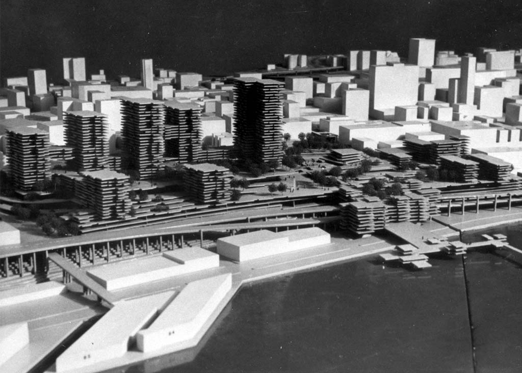
To facilitate automobile access to downtown, Monson called for an inner ring road and an outer ring road. The outer expressway ring road would be formed by constructing links between the Seattle freeway (Interstate 5) on the east and Highway 99 along the waterfront on the west. This outer ring road would allow traffic to circle the city outside of its congested streets. Then an inner ring road would replace Western Avenue on the west and run along the downtown side of the new interstate freeway on the east, providing access to city streets and to the four parking garages proposed for the four corners of the central business district: Pike Place Market, Pioneer Square, the Pike Street area between 7th and 8th avenues, and the municipal buildings district near Yesler Way, between 5th and 6th avenues. These parking garages would replace existing buildings, save for the Music Hall Theater and the Waldorf Hotel in the northeast corner.
At the site of Pike Place Market, a development called Pike Plaza would extend from Pike to Battery Street, between the Alaskan Way Viaduct and First Avenue. Atop a hillside garage, the multi-use development with offices, apartments, and retail space would replace the area's run-down buildings. Monson incorporated the public market into the development. The loss of the historic market buildings did not concern Monson:
"If the garage is to be built, the present makeshift structure covering the market will have to be replaced. This would happen in not too many years in any event. The charm and drawing power of the market is not in the sheds within which it now operates but in the character of the vendors, the quality of the produce sold, the attractive way in which they are displayed, and in the arrangement of the stalls and concession areas. The character of the market can be retained and reproduced under a new roof" (Monson, 40).
The Central Association estimated that the Pike Plaza project would return eleven times more tax revenue than the existing buildings.
A New View of the Waterfront
The Monson plan extended down to the central waterfront:
"If a downtown area has a waterfront which can be developed as its front yard, the city is indeed fortunate. It is not necessary here to argue that Seattle's waterfront should be redeveloped as a promenade connecting ferry terminus, public open areas, restaurants, marinas, boatels, and the like. Everyone knows of a city which has taken advantage of waterfront opportunities and greatly added to the attractiveness of its center by doing so" (Monson, 63).
The drawings that accompany the plan show the replacement of the existing piers and pier sheds with new piers and buildings that the city would lease to businesses to operate things like restaurants, concessions, and a motel.
Caroline Tobin, in her 1977 study of urban planning on Seattle's waterfront, explained that the Monson plan marked a change in how the waterfront was viewed in relation to the central business district. Instead of being left to industrial and transportation uses that would separate it from the downtown core, the waterfront was an integral part of Monson's vision for downtown. He recommended better connectivity with downtown, including a sky bridge from the base of the hill below Pike Street up to the Pike Plaza development.
While Monson dismissed most large-scale maritime uses of the central waterfront, including fishing and cargo handling, he did incorporate passenger-ship facilities in his plan. In addition to the existing ferry terminal, he included a marina and an air-water terminal with a heliport.
Monson proposed several ways to improve pedestrian circulation around downtown and between downtown and the waterfront. Escalators could carry pedestrians up the steep hills in the downtown core. Overpasses could provide routes for pedestrians over the railroad tracks and the steep hill between much of downtown and waterfront and under the Alaskan Way Viaduct. Pedestrian malls along several east-west streets in downtown, along with new parks, would make the downtown environment more like suburban neighborhoods and, in the opinion of many at the time, more enjoyable for shoppers and visitors.
Despite the auto-centric nature of the plan, mass transit was also included. Bus transitways, some of which would be dedicated to bus traffic only, would facilitate bus movement through downtown. Buses could also be used to carry passengers between shopping areas and office buildings and the new parking garages.
More Plans
Monson's plan was adopted by the Seattle City Council on November 26, 1963. It was incorporated into the city's comprehensive plan and used to apply for urban renewal funding. Other parts of Monson's proposal moved forward to more detailed planning. In 1965, the City of Seattle hired John Graham and Company, another New York-based planning firm, to further develop a central waterfront plan. Graham's plan formed the basis for a park proposal that was folded into the 1968 Forward Thrust parks bond measure. That bond funded yet another planning effort, the Rockrise study, which developed the concept Waterfront Park and a vision for how the park could anchor a complete makeover of the central waterfront. Waterfront Park opened in 1974, but it did not spark the wholesale redevelopment of the central waterfront as envisioned by Monson, Graham, and Rockrise & Associates. Fundamental obstacles, such as the Alaskan Way Viaduct, train traffic alongside Alaskan Way, and the large number of outmoded buildings would require decades to overcome.
The downtown elements of the Monson plan were largely derailed by the historic preservation movement that emerged in the 1960s. Bolstered by the 1966 National Historic Preservation Act, which codified the preservation of historic buildings and districts, activists shifted the conversation away from urban renewal and toward restoring buildings and preserving historically significant neighborhoods. Demolition of Pioneer Square for the southwest parking garage never occurred because the plan and other threats to historic buildings triggered a drive to create the Pioneer Square Historic District in 1970. The Pike Plaza project was initially reworked to accommodate the Pike Place Market Historic District when that was formed in 1971, but it was essentially nullified by the shift from urban renewal to historic preservation in the market and eventually abandoned.
