The ledge of level land on Seattle's central waterfront owes its existence to the Alaskan Way seawall, extending from just north of Broad Street south to Washington Street below Pioneer Square. The southern portion, in the shallower water south of Madison Street, was constructed in the 1910s and 1920s; the more challenging northern portion was completed in 1936. The wall holds back the sea from the quarter-million cubic yards of fill placed behind it to provide solid, level ground on which to build streets, lay railroad tracks, and handle passengers and freight moving between land and sea. The seawall fundamentally altered the shoreline environment, redefining the central waterfront and creating space for a north-south transportation corridor that would soon eclipse the traditional maritime activities on the central waterfront.
Little Level Land
Non-Indian settlers chose the Elliott Bay shoreline that would eventually become downtown Seattle for their townsite in the 1850s because it offered two important advantages for a city at that time: a deep-water harbor and a hinterland rich with natural resources. The fact that the harbor's shoreline then offered very little level land for living and working did not deter them. As was common in cities across the country, they knew they could regrade hills, build piers to deep water, and construct seawalls to protect made land or filled areas.
At first, settlers made use of the existing level land -- the area now known as Pioneer Square, but then called variously djidjila'letch ("Little crossing-over Place"), Piner's Point, and Maynard's Point. That finger of land extended south from where Yesler Way and First Avenue are today to about where King Street is. From the point, shallow tideflats extended east to the base of Beacon Hill and south to the mouth of the Duwamish River. Along the western shoreline, the seafloor sloped quickly to the bay's deep water.
Bluffs and steep hills edged the beach to the north and southeast. While homes and some businesses could function on the slopes, early industries such as exporting lumber and coal, on which the city's leaders hoped to build its future, needed level space for transporting, processing, and storing products and supplies. The effort required to create new level land with massive earth-moving projects remained beyond their ability at the beginning, so other solutions were tried.
Piers and Railroads
When Henry Yesler (1810-1892) built the first sawmill in Seattle, he solved the immediate problem of getting logs and lumber to sailing ships from his sawmill, located on the shoreline near today's First Avenue and Yesler Way, by building a pier out to deep water. Others who needed to ship or receive cargo or load passengers added onto Yesler's pier so that, according to J. Willis Sayre, "that wharf grew with the village; by the early '80s it was more than 900 feet long, a miniature town of shops, stores, and warehouses" (Sayre, 2).
Yesler and others also began the process of filling in the low areas near the shore. Sawdust and the slabs cut off logs to square them up for cutting into dimensional lumber were dumped below the pier, gradually building up the shoreline and extending it westward. As the number of sawmills operating on the waterfront increased over the next several decades, their refuse eventually filled large areas of shoreline.
The arrival of rail travel boosted Seattle's growth, but as the city expanded and a tangle of piers grew out from shore, railroad access to the waterfront became increasingly difficult. Coal and lumber companies needed to get cargo trains directly to the waterfront, but pier owners did not want access blocked by railroads crossing their piers. Tracks had to run along the shore because the adjacent hills blocked rail-building farther inland. The issue was further complicated by the concerns that transcontinental railroads would gain control of waterfront commerce by dominating access to deep water.
To prevent that from occurring and to bring some order to the waterfront, the city council passed an ordinance in 1887 establishing Railroad Avenue. This "street" was essentially a right-of-way over the tidelands with the westernmost portion awarded to a local railroad, the Seattle, Lake Shore & Eastern. Piers jutted out from the western margin of the right-of-way. The tidal area between Western Avenue (built largely along the original beach line) and Railroad Avenue gradually filled with railroad tracks on trestles, and planked streets and buildings perched on pilings, so that it appeared to be an extension of solid ground.
The tens of thousands of prospectors who passed through Seattle on their way to the Klondike Gold Rush of 1897 cemented Seattle's role as the supply depot for Alaska. The waterfront, already serving the Mosquito Fleet (the small steamers that crisscrossed Puget Sound); cargo ships carrying lumber, coal, fish, farm produce, silks, and other goods to ports around the world; passenger liners connecting Seattle to every continent; and the fishing fleet, became even more congested with people, goods, and livestock.
Makeshift and Filthy
Though the center of much of Seattle's economy, the central waterfront lagged behind the rest of the city in modernization. An April 1908 editorial in the Seattle Post-Intelligencer bemoaned the sorry state of the waterfront: "there, and there alone, are the makeshifts of a pioneer era permitted to remain. Instead of permanent concrete docks there are temporary wharves of piling, rapidly crumbling under the ravages of the teredo" ("No Further Makeshifts"). (The teredo is a burrowing marine worm that plagues underwater wooden structures). The editors called on the city to build a seawall to meet the needs of the busy port.
Meanwhile, a more urgent situation stewed among the pilings. In October 1907, Leong Seng, an immigrant from China, succumbed to bubonic plague. A handful of additional cases were reported and the city health department sprang into action, searching for the source of the outbreak. Not surprisingly, rats bore the blame and, even less surprisingly, the infected rats were traced back to the waterfront.
Health department inspectors found foul-smelling and repulsive conditions. A sewer main had broken in the area of First and Cherry, producing a "lake of sewage" that an editorial described as "several feet deep" ("Crighton Closes Business Houses"). Additionally, "tons and tons of refuse from the chicken section" lay between the pilings supporting a meat-company building located near the lake of sewage -- apparently a hole in the floor had served as a "garbage chute" ("Crighton Closes Business Houses").
This situation was hardly isolated. In April 1908, Commissioner of Health J. F. Crighton wrote to the mayor and council, "Between Railroad and Western Avenues there is a vast amount of rotting timbers, planks, boxes, and all kinds of garbage, the waste of commission houses, restaurants, and markets. Within this district are broken sewers and cesspools. One cesspool in particular is thirty feet long, fifteen to twenty feet wide, and from eight inches to two feet deep, filled with the most horrible filth that it is possible to imagine" (Commissioner, April 4, 1908). Dr. F. S. Bourns summed up the situation in The Seattle Times: "Seattle is the ideal breeding ground for rats. For Seattle is filthy" (Bourns).
The Board of Health's first response focused on eradicating rats by trapping them and determining how many were infected. In 1908 alone, city workers trapped or paid a bounty on 57,299 rats and necropsied 49,505 of them. Health authorities next addressed underlying causes of the disease outbreak -- primarily the filthy conditions on the waterfront. Some buildings were razed and others renovated to replace their wood foundations with cement. Some of the lower areas were filled in by property owners or the city.
Plans for a Seawall
In response to the rat situation city officials also studied building a seawall along the central waterfront, but it would take several decades to construct one because of the sharp drop to deep water along that stretch of shoreline. In the same way that bluffs impeded growth inland, the steeply sloped seafloor limited the city's ability to build a seawall economically between Madison and Pike streets. Unlike the waterfront farther south, which was relatively shallow, water depth there measured 25 feet at low tide, with up to 12 more feet at high tide.
A conventional seawall, known as a gravity wall, relied on pilings driven into solid soils underground with a concrete wall on top. This design worked in places where fill behind the wall did not place too much outward pressure on the wall and the depth of water did not require a wall too tall and heavy to be supported and held in place by the pilings, so it was not feasible for the central waterfront.
The needs of waterfront users also prevented the city from building less expensive walls. If the wall was built farther inland, there would not be sufficient room for trains and other traffic to move along the base of the hillside to the piers. The wall also could not be constructed with a less-expensive sloped pile of riprap extending out into the bay because the wide base required to reach the necessary wall height would reduce the usable length of the piers, which already extended as far into the bay as they could with the height of piles available.
Several issues intersected to complicate financing a more expensive seawall that would address the issues on the central waterfront. A state law, later amended significantly, required that adjacent property owners, as part of a local improvement district, pay part of the costs of any street improvements. The law also allowed them to block projects, which they did often with seawall proposals. Additionally, only one-half the total cost could be assessed to the property owners, and the city did not have funds to pay its portion.
First Steps
In the 1910s and 1920s the city and the Port of Seattle built a seawall in the shallower water south of Madison Street. The portion between Washington and Madison, completed in 1916, was a conventional gravity wall built of unreinforced concrete resting on pilings. By 1928, the beach behind it had been filled and Railroad Avenue paved. Even there, with a shallower slope, the seawall did not completely hold back the fill. In 1929 the pavement settled between Madison and Washington streets because the fill underneath it had worked its way under the concrete wall as a result of tidal action eroding the soil at the base of the wall and the pressure of the fill pushing down the seafloor slope.
City officials made note in 1921 of the instability of the sloped seafloor when a newly built trestle collapsed at Madison Street. After analyzing the failure, they concluded that the weight of bricks and concrete discarded from a repaving project on First Avenue onto the beach had caused the seafloor to slide. They determined that "any stable type of sea wall must impose very little weight on the bottom" ("Railroad Avenue Seawall").
In the 1920s the city began looking for new solutions to the situation north of Madison. Increased automobile traffic moved more quickly and carried heavier loads, making it very difficult and expensive to maintain planking on the elevated streets. Planking deteriorated and parts of the street had to be closed until they could be repaired. Sometimes, weakened planks or pilings gave way unexpectedly and vehicles plunged through to the beach below.
The city began preliminary work toward building a northern seawall in the 1920s. To address the sprawling, unwieldy, and unsafe railroad tracks along Railroad Avenue, officials negotiated with the railroads to amend their franchises to decommission several of the nine sets of tracks along the waterfront and shift remaining tracks to the east side of the right-of-way. The 1929 agreement that resulted freed up space for dedicated vehicular lanes, something Railroad Avenue had always lacked, causing great peril to wagons and cars dodging trains shunting along the waterfront. It also made room for a sidewalk along the far western margin, greatly increasing pedestrian safety.
Finding Funds
Funding issues continued to plague the project, particularly after the Great Depression began in 1929, further reducing property owners' ability to pay their portion. The city estimated the project would cost $1.4 million. In March 1932 voters approved a $600,000 bond measure, but the project also relied on a $600,000 assessment on property owners and additional state funding. Mayor John Dore (1881-1938) called Railroad Avenue a "death trap" and "a menace to the life of all that use it," and warned that, "daily the hazard is run of taking human life by inaction" (Dore veto), but funding still proved elusive. Property owners threatened to block the project by protesting the assessment and the mayor feared state funding would not be allocated or other important projects would go unfunded.
Finally, in November 1933, the pieces fell into place. The property owners agreed to pay $400,000 if the city secured $396,000 from the State Emergency Relief Fund, which it did. In the ordinance creating the project fund, the city council stated, "Whereas, widespread and acute distress exists among the unemployed inhabitants of this City to such an extent as to endanger the immediate preservation of order and the public health and safety, and it is therefore expedient and necessary that work on the construction hereby authorized be commenced at the earliest possible date in order to provide employment" (Ordinance No. 64217).
Although the cost of the seawall caused concern, the environmental consequences of covering the tidelands did not. The seawall fill buried vast areas of the intertidal zone on Elliott Bay. Added to the loss of the estuary at the mouth of the Duwamish River and the tidelands south of King Street, the result was obliteration of shellfish beds and acres of marine and shoreline habitat that had sustained a rich web of plants and animals. Generations of Coast Salish manufactured a wide variety of household goods and implements out of materials gathered from the estuary and along its edges, and ate the shellfish, fish, and plants that thrived there. They also traded those resources in a wide-reaching trade network that reached north along the Inside Passage and across the Cascade Mountains. The cultural and environmental losses were tremendous, but in the calculations of the time, not significant enough to merit attention.
Seawall Design
Design work had proceeded while the funding battle played itself out. The city's engineers planned two types of seawalls. Type A was designed for the area from Pike Street north to Bay Street (located between Denny Way and Broad Street and later bounding Olympic Sculpture Park on the north), where the water was somewhat shallower. It consisted of a concrete seawall atop a steel sheet piling that was driven below the soil line. The concrete portion was connected to a timber structure on the inland side. The timber structure consisted of plumb pilings, driven vertically into the ground, batter pilings driven at an angle, pier caps that formed a grid connecting to the piles, and a relieving platform across the top of the pier caps made of wooden planks. The relieving platform was located underground and used the weight of the fill on top of it to counterbalance the gravitational forces pushing the wall outward. The street was built above the relieving platform and the sidewalk was cantilevered out from the top of the seawall face.
The Type B design was used between Madison and Pike streets, where the water reached its greatest depth. The relieving platform extended 20 feet farther inland and more pilings were driven to anchor the pier caps. The steel sheet pilings extended above the seafloor and were topped with a concrete wall and the entire wall was backed by steel I-beams. Tie rods connected the steel sheet piling to the relieving platform. The sidewalk was also cantilevered out from the wall as in the Type A design.
The relieving-platform design reduced cost by changing the construction method. Instead of having to build cofferdams to create dry space for pouring concrete footings and the wall, the concrete and steel portions of the wall could be constructed off site and placed in the water. The pilings could be driven into the water too, so the only necessary accommodation for the water would be waiting for low tides to place the precast concrete slabs.
Riprap piled up against the base of both types of seawall helped protect it from the eroding effects of tidal action, both on the face of the wall and on the soil along its base. This helped limit the amount of fill that could work its way out from behind the wall through cracks and at the seams between the concrete and steel portions of the wall.
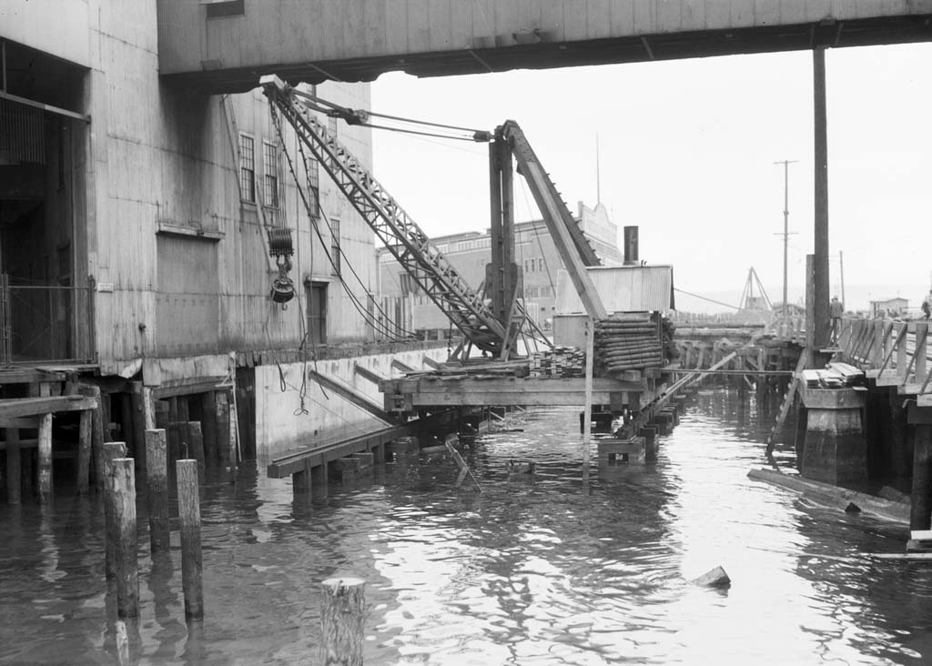
Building the Wall
In April 1933, the city deadline for bids passed without any submissions. Another call for bids was similarly unanswered in January 1934. The innovative design of the seawall made the project somewhat risky and the city could not find a general contractor willing to take on the project. City officials decided to manage the project themselves, hiring day laborers for portions of the job and letting contracts for materials, such as the steel sheet piling, and portions of the project that required specialized equipment, such as the pile drivers. All contracts were subject to the approval of the King County Welfare Board because the state emergency-relief funding had specific requirements for who could be hired and under what conditions and pay rates. Materials had to conform to the regulations of the National Industrial Recovery Act.
The first contract was let in January 1934, when Manson Construction and Engineering was hired to drive 44 test piles along the length of the work area. The project files in the city archives are full of specifications and contracts signed with numerous companies for all of the different parts and processes of the seawall's construction. The Columbia, Lockwood, Farrell, and Elliott Bay lumber companies provided 1.2 million board feet of dimensional lumber. Northwest Steel Rolling Mills provided 27,920 drift bolts in three different sizes. Manson Construction drove 8,200 batter (angled) piles and 10,000 plumb (vertical) piles. Crosby Sand and Gravel supplied ready-mix concrete that day laborers made into wall slabs, sidewalks, and railings. Bethlehem Steel in West Seattle provided the reinforcing steel that was used in the wall slabs. The city bought the steel-sheet piling from three companies -- Puget Construction Steel, Columbia Steel, and Inland Steel. Managing the paperwork alone was a major endeavor.
Construction crews made use of the tide in placing the pier caps. Sections of pier-cap grids were constructed off-site, at the city's yard on Harbor Island, with each piling connection point pre-cut according to measurements of the pilings. Sections were floated in at high tide and allowed to descend into place as the tide receded.
After sections of the wall were complete, Washington Tug and Barge Company brought in scows filled with gravel from the mouth of the Cedar River in Lake Washington to fill the newly dry land. The roughly 270,000 cubic yards of gravel traveled via the Lake Washington Ship Canal and through the Ballard Locks, then around West Point to Elliott Bay. Each of the 667 loads was placed behind the wall by cranes that scooped it off the deck of the scow and dropped it on the eastern margin of Railroad Avenue. From there, it was sluiced into place to prevent the formation of voids that might settle later.
In November 1934 the city engineering department requested that the Board of Public Works approve an alternate design for the railing along the sidewalk. The original design had called for galvanized pipe and mesh to form a railing that would be painted. Concerns that the appearance of the railing would rapidly degrade led the city to redesign it using concrete. Sections of the railing, posts, rails, and pickets, could be precast and placed along the sidewalk as it was completed. Plans also called for cast-bronze ship wheels as decoration and cast-bronze rosette bolts on the larger posts that were placed at intervals along the railing.
Alaskan Way
Suggestions flooded in from around the state for naming the new street built atop the fill in place of trestle-borne Railroad Avenue -- Cosmos Quay, Seawall Avenue, The Battery, Dock Street, Port Strand, Bois Boolong, Salt Spray Way, Export Way, and many more. No decision was made until after work on the seawall and other improvements concluded, the last fill was placed in August 1936, and the entire project was completed that December. The city then settled on "Alaskan Way," suggested by a local group, the Alaska-Yukon Pioneers. The Argus noted that the name "dignifies its importance and emphasizes its traditions as the point from which the argonauts embarked for the gold fields of the north" (July 18, 1936). The name also highlighted the continued importance of the Alaska trade for Seattle, even as trade to other parts of the world increased.
Celebrations of the new Alaskan Way were held in November 1937, when the Alaska-Yukon Pioneers held a "civic exposition," and again in July 1938 during Potlatch Days. The exposition included exhibits by Alaska towns and celebrated gold-rush history with replicas of dance halls and displays of "Alaska relics" like the strong box that had held the first load of gold brought to Seattle from the Klondike in 1897. The Potlatch Days celebration featured a ribbon cutting and the christening of the street by Sourdough Queen Mary Winje with water from Puget Sound.
The wall functioned exactly as intended. It allowed the waterfront to operate on solid ground and ended the continual monitoring and maintenance of pilings and planking. Trains, automobiles, and pedestrians could navigate the waterfront more easily and safely, though the ease of travel attracted so many vehicles hoping to bypass congested downtown streets that by 1939 the Propeller Club, a maritime-commerce group, had petitioned the city to address traffic issues on Alaskan Way. The petition asserted, "The use of the waterfront as a traffic 'bypass' is gravely harming our most vital industry --- shipping. Relief must be obtained promptly if irreparable damage to the city's maritime commerce is to be avoided" (Report Propeller Club). The eventual resolution of the traffic issue was the Alaskan Way Viaduct, whose first section opened in 1953.
Maintenance and Replacement
Regular inspections of the seawall beginning in 1937, found only minor problems until 1949, when the sheet piling showed significant corrosion, caused by electric charges, which occurred naturally in the water, moving in and out of the steel. The resulting small cracks allowed seawater to get behind the wall each time the tide rose. As the tide receded, some of the fill behind the wall escaped through the cracks. By the 1960s, this would lead to settling of the fill around the relieving platform. Though this does not appear to have affected the function of the relieving platform, it did create voids just below the untreated timbers that made up the pier cap and pilings. When the tide rose, those voids filled with water, which inevitably carried marine borers (primarily teredos and gribbles) in it. They slowly began to eat away the timbers.
The city first added riprap to the base of the wall to try to reduce the amount of fill escaping from behind it. More was added periodically as existing riprap subsided along the front of the wall. Then, in 1959, a cathodic protection system was installed. This entailed placing anodes at various locations along the wall to collect electric charge and discharge it back into the surrounding environment before it could enter the seawall's metal components. More cathodic protection was added in 1972 and a 1979 study found it to be largely working.
Tidal action and storms also caused wear and tear on the seawall. By the 1980s the structure was aging and more structural issues had developed. A 1981 report said "the seawall has become a serious maintenance problem" (Subsurface Explorations ..."). In 1986, the city refaced 1,400 feet of the wall with ekki wood (a dense hardwood resistant to marine borers), and that effectively shored up the seawall.
After the 2001 Nisqually earthquake, concerns about the structural integrity of the Alaskan Way Viaduct drew public attention. Government agencies had been assessing the stability of the viaduct for some time. Officials had also been concerned about the integrity of the seawall. When a 1,000-square-foot section of Alaskan Way settled following the earthquake, it became more apparent how fragile the seawall structure was. At about this time, Seattle Department of Transportation began planning for replacing the seawall. In 2004, city inspectors were surprised to find that 40 percent of the ekki wood boards had been damaged by borers, a significant increase from the 3-percent damage rate noted a year earlier. Concerns were raised that the wall could fail completely in an earthquake.
The City of Seattle and the Washington State Department of Transportation decided to combine replacement of the seawall and viaduct into one project in 2002. They presented several proposals for replacing the viaduct, one of which was a cut-and-cover tunnel with a new seawall serving as the tunnel's western wall. After a prolonged public debate, the city, state, and Port of Seattle decided in 2009 to replace the viaduct with a bored tunnel, and the seawall replacement was separated from the tunnel project. City engineers developed a plan to replace the seawall using a soil improvement method called jet grouting to reduce the chance of liquefaction during an earthquake, install new facing for the seawall, and improve marine habitat along the wall. Construction for the seawall replacement began in November 2013, with a projected completion date of spring 2016.
