On August 20, 1845, two days after being passed by Oregon's Provisional Legislature, the act creating Vancouver District, a huge area north of the Columbia River including what will later become Washington's Clark County, is signed by Governor George Abernethy (1807-1877). Later that year the provisional government will form Lewis County from the western portion of Vancouver District and change the name of the latter to Vancouver County. The provisional government was formed by early American settlers and claimed authority over a huge area that the United States and Britain had been haggling about for decades. It may have no legal authority to create political subdivisions, but the establishment of Vancouver County will be implicitly ratified in 1849 when the first session of the Oregon Territorial Legislature changes its name to Clark County, in honor of William Clark (1770-1838) of the famed Corps of Discovery. When Washington Territory is established in 1853, all of Clark County will be included in its boundaries (although it will be spelled as "Clarke County" until corrected in 1925).
Legal Limbo
In 1818 the United States and Great Britain agreed that for a period of 10 years their "citizens and subjects" would share joint occupancy of "the North West Coast of America, Westward of the Stony [Rocky] Mountains" (Convention of 1818). The British presence in what was then known only as Oregon Country was largely that of the facilities and personnel of the Hudson's Bay Company, which established Fort Vancouver on the north bank of the Columbia River in 1825. The land to the south of the river remained for the most part Indian territory, with a scattering of non-Native fur traders and missionaries.
When the 10-year joint-occupancy agreement expired in 1828, the two nations agreed to establish a permanent international boundary within one year, but what was termed the "Oregon Question" remained unresolved for nearly two more decades. The control of a vast region that stretched from the northern border of California north to the 54th parallel (the southernmost boundary of today's Alaska panhandle), and from the Continental Divide in the east to the Pacific Ocean, remained in dispute.
The settlement of the Northwest did not wait for the drawing of international boundaries. By the early 1840s the claims of Great Britain to what are now Washington and Oregon were being overwhelmed by events. In growing numbers, migrants claiming American citizenship were moving north from California or trekking overland from the east on the Oregon Trail. Most of the early arrivals settled in the long and fertile Willamette Valley, but some slowly pushed north across the Columbia River.
These first American settlers in Oregon Country lived in legal limbo on land that was claimed by two nations, but actively administered by neither. They had no formal representation in the governing councils of either the United States or Great Britain, no written laws, no central authority. As one near-contemporaneous historian described their plight:
"American immigrants, although from year to year they hoped to see the paternal care of their government extended over them, were from time to time doomed to bitter disappointment, and to realize that they were without just and equitable laws to govern them, and to feel that they occupied the extraordinary and in every way anomalous position of a people who, without having ... renounced their country, or been renounced by it, were, nevertheless, without one" (Thornton, 28).
The need for some system of government and laws was acutely felt in 1841 when Ewing Young (1799-1841), a former mountain man who had settled in the Willamette Valley and amassed significant assets, died without heirs. Neighboring settlers gathered to decide how to distribute Young's estate in the absence of any legal guidelines and voted to appoint a committee to formulate a civil code of laws. This effort foundered, but the need for governance grew ever greater.
Easier Said than Done
However, forming a functioning government was not all that easy. Distances were long, roads non-existent, communications difficult. Nonetheless, in February 1843 an ad hoc body called the Oregon Legislative Assembly was established in the Willamette Valley to do the heavy lifting of creating a government from scratch. According to a list compiled by the Oregon State Legislature in 2008, this constituted the first meeting of Oregon's first legislature. The second meeting of that initial Oregon Legislative Assembly was held in June and July 1843 by a legislative committee chosen at a public meeting held on May 2, 1843, in the tiny community of Champoeg on the Willamette River.
At that same public meeting, the settlers present approved the formation of a provisional government in a close vote. One account states that 102 men voted -- 50 Americans and 52 French Canadians, the latter almost all former Hudson's Bay Company employees who had settled in the Willamette Valley. After much maneuvering, the formation of a provisional government was approved by a vote of 52 to 50, with two French Canadians siding with the Americans (Holman, 24).
Between 1843 and July of 1845 the legislative committee met four times in what were later designated as "pre-provisional" sessions ("Pre-Provisional Government Period"). The committee began cobbling together a government and composing an Organic Act, a task made far easier by the wholesale adoption of the statutes of Iowa. The settlers ratified the Organic Act at a meeting on July 5, 1843, and decreed the existence of what they called the Oregon Provisional Government. By the end of August the boundaries of four districts (later to be called counties) south of the Columbia River had been set.
A message was sent east advising President James K. Polk (1795-1849) of the settlers' efforts at self-government ("Oregon History: The 'Oregon Question' ... "). He and his administration took little notice -- they were very interested in acquiring exclusive control of the Pacific Northwest and believed the rapidly growing American presence supported those claims, but they showed scant interest in what the locals were up to in the meantime.
Vancouver District
One of the things they were up to was extending the authority of the provisional government to areas north of the Columbia River. On August 18, 1845, the Oregon Provisional Legislature passed an act that, as quoted decades later, read:
"Be it enacted by the House of Representatives of Oregon Territory as follows
"That all that portion of the Territory of Oregon lying north of the middle of the main channel, of the Columbia River, shall be and the same is hereby declared a seperate [sic] District, under the name and style of Vancouver District and the said District shall be entitled to elect one member of the House of Representatives, at the next annual Election" (Holman, 4).
Governor George Abernethy signed the act creating Vancouver District on August 20, 1845.
Some sources date the creation of Vancouver District to June 27, 1844, rather than August 1845. This claim appears to be based on an act passed by the Provisional Legislature on that date, which adjusted the borders of three already-created counties by making the Columbia River their northern boundary. The June 27, 1844, act dictated "that all those parts of any Counties heretofore organized which lie north of the Columbia river be and they are hereby stricken off respectively, and that the said river shall constitute the northern boundary of said Counties respectively" (Holman, 10). However, while the 1844 legislation removed the territory north of the Columbia, including what ultimately became Clark County, from existing counties, it does not appear to have created a new county or district within that territory, leaving the act signed by Governor Abernethy on August 20, 1845, as the legislation that created Vancouver District.
On December 21, 1845, the Oregon Provisional Government changed the name of Vancouver District to Vancouver County and carved from its huge expanse a new county that included all of the territory west of the Cowlitz River and stretched from the north bank of the Columbia River to the 54th parallel far to the north. This was named Lewis County, after Meriwether Lewis (1774-1809) of the Corps of Discovery.
Clark County, Oregon Territory
The long dispute between Great Britain and America was finally resolved with the Oregon Treaty of 1846, which established a dividing line at the 49th parallel (with the exception of a jog to south to permit all of Vancouver Island to be included in the British sector). Oregon Country south of the agreed boundary was now part of the United States and subject to its laws, but not yet a formal territory. The settlers still had their provisional government, and its representatives continued to meet and legislate. They set up a court system and in a disreputable step passed a law forbidding permanent residency to African Americans, slave or free.
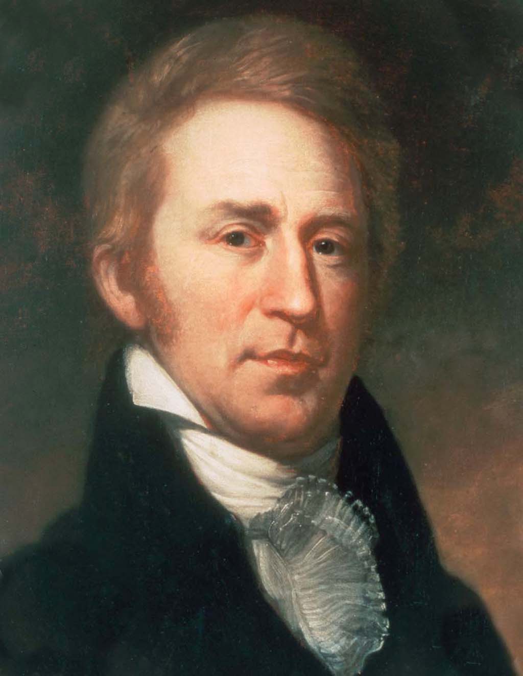
On August 14, 1848, President Polk signed the congressional act that formally established Oregon Territory, an area that then included all of present-day Oregon, Washington, and Idaho; the western extremity of Montana; and a wedge of western Wyoming. Joseph Lane (1801-1881), a hero of the Mexican War and a resident of Indiana, was appointed territorial governor and made the trek overland to be inaugurated at Oregon City on March 3, 1849. On July 16 of that year the first regular session of the Oregon Territorial Legislative Assembly convened at that place, and on September 3 it enacted a statute stating "That the name of the county of Vancouver be, and hereby is, changed to Clark" ("An Act to Change the Name ... "). This was a tribute to explorer William Clark, co-leader with Meriwether Lewis of the Corps of Discovery, which had reached the mouth of the Columbia River from the east in 1805.
Clark County, Washington Territory
The seat of government for Oregon Territory was in Oregon City in the Willamette Valley, and the residents of the territory living north of the Columbia River soon became dissatisfied with their distance from the capital and the difficulty of reaching it to participate in their governance. At that time there were three counties of Oregon Territory located north of the Columbia -- Clark, Lewis, and Pacific -- and the region was commonly referred to as North Oregon.
In August 1851 a group of North Oregon settlers met at Cowlitz Landing and resolved to petition Congress to create a new territory bounded on the south and east by the Columbia River, but including the Walla Walla Valley ("Settlers of North Oregon ... "). Although the Oregon territorial government had no objections to the proposal, the settlers' petition was unpersuasive, with much of it devoted to anecdotal criticism of the Hudson's Bay Company. Congress took no action on it, at least in part because the issue of whether to permit slavery in new territories was being fervently debated at the time.
In December 1852 the former governor Lane, now Oregon Territory's non-voting delegate to the U.S. House of Representatives, presented a resolution there to create a Columbia Territory out of North Oregon. In February 1853 the resolution was amended to change the proposed name of the territory to "Washington," both to honor the nation's first president and in an (utterly failed) attempt to avoid confusion with national capital in the "District of Columbia." On February 10, 1853, the bill passed the House. In addition to accepting the name change, the final legislation moved the proposed eastern boundary of the new territory from the Columbia River to the Rocky Mountains, tripling its size to more than 100,000 square miles. The Senate concurred on March 2, 1853, President Millard Fillmore signed the bill the same day, and that portion of Oregon Territory north of the Columbia River became the new Washington Territory. By that time the Oregon Territorial Legislature had created, in addition to Clark, Lewis, and Pacific, five additional counties north of the river: Thurston, Pierce, King, Island, and Jefferson. Clark County was by far the largest, covering not only what is now Clark County but most of the area between the crest of the Cascade Range and the Columbia River as far as the American-British border at the 49th parallel.
An Unfortunate Misspelling
In 1854 the new Washington Territorial Legislature went on an orgy of county creation and by the time its inaugural session ended they numbered 16. Clark County was whittled down to close to its present boundaries, with much of its original expanse being used to create Skamania and Walla Walla counties. For reasons still in dispute statutes passed that year consistently spelled Clark County as "Clarke" County. One, entitled "An Act to Apportion the Representation of the Legislative Assembly," lists the 16 existing counties, including two references to "Clarke" spelled with the terminal "e." ("An Act to Apportion ... "). There was also a law passed placing the county seat of "Clarke County" at "Columbia city on the east portion of Mrs. Esther Short's land claims" ("An Act to Locate the County Seat ... "). The next legislative session, in 1855, also used the incorrect spelling, with the single exception of a law siting the territorial penitentiary in "Clark County" ("An Act to Locate the Penitentiary ... ").
For the next 70 years, every territorial and then state law referencing the county used the spelling "Clarke," as did the newspapers of the day and contemporary historians. It seems that everyone had forgotten how William Clark spelled his name.
Accidental or Intentional?
Who bears the blame for the original misspelling has been a matter of some dispute. Historian Edmond S. Meany, in his Origin of Washington Geographic Names, published in 1923, bemoans the "blunder," but muses that it "is probably now too deeply imbedded in law, literature and custom to be completely corrected" (Meany, 48). He notes that the misspelling appeared in statutes passed in the very first session of the Washington Territorial Legislative, then points out that "the question was ably discussed by Frederick V. Holman" in an address delivered to the Oregon Historical Society in 1909 (Meany, 48).
What Meany omitted to say was that Holman had a very specific bone to pick. A volume published in 1892 by T. O. Abbott, titled Real Property Statutes of Washington Territory from 1843 to 1889 Comprising the Laws Affecting Real Property, brought together in one place all Washington laws relating to real property, including those passed by the Oregon Territorial Legislature before Washington achieved territorial status. This was needed, Abbott states in his preface, because "The statutes of the late Territory of Washington are so difficult of access as to render the phrase 'out of print' specially applicable, if not literally correct" (Abbott, iii). It was a valuable, indeed indispensable, volume, but it contained one glaring error that Holman wanted to set right.
One of the statutes Abbott included was the September 3, 1849, law passed by the Oregon Territorial Legislature changing the name of Vancouver County. The original text clearly stated that it was to be changed to Clark County, the correct spelling. However, Abbott's rendition of the statute used the spelling "Clarke," seemingly placing the blame for the original error on the Oregon Territorial Legislature, rather than Washington Territory's legislature where it belonged. Abbott's compilation was considered authoritative and often cited. Holman noted that "It is to be regretted that so valuable a work is thus marred" (Holman, 6). Both Meany and Holman concluded that "Clark" County was what the Oregon Territorial Legislature renamed Vancouver County, and that the erroneous addition of the "e" came later. Holman, for reasons that are less clear, believed that Abbott's mistaken attribution of the origin of the "e" "was not done inadvertently" (Holman, 6).
Back to What It Always Was
Even though no Oregon or Washington law, territorial or state, had ever formally changed the name of Clark County to Clarke County, after the publication of Meany's volume it was decided that a law was needed to make things right. In 1925, 71 years after the error first appeared in the statute books, the Washington State Legislature passed "An Act to Correct the Spelling of the name of Clarke County." It reads, in its entirety: "The name of Clarke County is hereby changed to Clark County, dropping the final 'e' in accordance with the spelling of the name of the explorer William Clark of the Lewis and Clark Expedition in whose honor the county was named." Of course, it always was Clark County in reality, and although it certainly did no harm to verify this spelling by statute, the law likely is unique in having as its sole purpose a deletion of the letter "e."
The heart of the mystery remains: Given the fame of William Clark and the appropriateness of naming a county after him (just as Lewis County was named after his exploring partner) how could such a mistake have occurred in the first place? Interestingly, in Lewis County about 60 miles north of the Columbia River was a settlement called Cowlitz Landing near present-day Toledo. It had been included in the original boundaries of Clark County and would become a departure point for American settlers moving up the Cowlitz River into Puget Sound country. As noted earlier, it was at Cowlitz Landing in 1851 that the settlers of North Oregon first gathered to petition the federal government to create Columbia Territory. While it may be pure coincidence, the place they gathered was called the Clarke Hotel, and there are several references to "Clarke's hotel" in the 1854 statutes where the county name's misspelling first appears.
