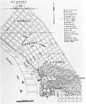
On May 23, 1853, Arthur Denny (1822-1899), Carson Boren (1824-1912), and Dr. David S. Maynard (1808-1873) file the first plats for the Town of Seattle and establish the present-day street grid in Pioneer Square and downtown Seattle.
The platting process did not go smoothly. As Arthur Denny later told the story, "Doc" Maynard came to the planning meeting "stimulated by liquor" and decided "that he was not only monarch of all he surveyed but what Boren and I surveyed as well." Maynard stubbornly insisted on orienting his streets according to the cardinal points of the compass while Denny and Boren laid theirs out to parallel the shore of Elliott Bay. They agreed to disagree and the result was a permanent tangle of mismatched roads at Yesler Way (then called Mill Street or "Skid Road") where the divergent grids abut.
Sources:
Clarence Bagley, History of Seattle (Chicago: S.J. Clarke Publishing Co., 1916); Bagley, History of King County, Washington (Chicago: S. J. Clarke Publishing Co., 1929); Murray Morgan, Skid Road: An Informal Portrait of Seattle (New York: Viking Press, 1951).
Licensing: This essay is licensed under a Creative Commons license that
encourages reproduction with attribution. Credit should be given to both
HistoryLink.org and to the author, and sources must be included with any
reproduction. Click the icon for more info. Please note that this
Creative Commons license applies to text only, and not to images. For
more information regarding individual photos or images, please contact
the source noted in the image credit.

Major Support for HistoryLink.org Provided
By:
The State of Washington | Patsy Bullitt Collins
| Paul G. Allen Family Foundation | Museum Of History & Industry
| 4Culture (King County Lodging Tax Revenue) | City of Seattle
| City of Bellevue | City of Tacoma | King County | The Peach
Foundation | Microsoft Corporation, Other Public and Private
Sponsors and Visitors Like You

