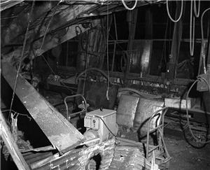
On February 14, 1946, at 7:18 p.m. an earthquake strikes, centered between Olympia and Tacoma.
The most damage occurred in Seattle’s filled-in waterfront and tideland industrial area. The epicenter of the magnitude 6.3 quake was located at 47 degrees 18’ 00” North Latitude and 122 degrees 54’ 00” West Longitude. The quake was felt over a 165,000 square mile area.
Sources:
S.T. Algermissen and Samuel T Harding, The Puget Sound, Washington Earthquake of April 29, 1965 (Washington, D.C.: U.S. Coast and Geodetic Survey U.S. Government Printing Office, 1965), 4; Linda Lawrance Noson, Anthony Quamar, and Gerald W. Thorsen, Washington State Earthquake Hazards (Olympia: Washington Department of Natural Resources, Division of Geology and Earth Resources Information Circular 85, 1988), 22, 49.
Licensing: This essay is licensed under a Creative Commons license that
encourages reproduction with attribution. Credit should be given to both
HistoryLink.org and to the author, and sources must be included with any
reproduction. Click the icon for more info. Please note that this
Creative Commons license applies to text only, and not to images. For
more information regarding individual photos or images, please contact
the source noted in the image credit.

Major Support for HistoryLink.org Provided
By:
The State of Washington | Patsy Bullitt Collins
| Paul G. Allen Family Foundation | Museum Of History & Industry
| 4Culture (King County Lodging Tax Revenue) | City of Seattle
| City of Bellevue | City of Tacoma | King County | The Peach
Foundation | Microsoft Corporation, Other Public and Private
Sponsors and Visitors Like You

