On March 3, 2008, the King County Council approves Ordinance No. 16028, which will allow farmers in the Enumclaw Plateau Agricultural Production District (APD) and the county's other APDs to diversify their businesses by processing harvests onsite. The Enumclaw Plateau Agricultural Production District has a rich agricultural history, including a short stint in commercial hops production and successes in dairying and chicken ranching. The Enumclaw Plateau is the largest of the five Agricultural Production Districts created in 1985, with a primary land use in livestock/forage. Despite establishment of the APDs, and the earlier creation of a Farmland Preservation Program, the Enumclaw Plateau like the rest of the county sees ongoing loss of agricultural land. The ordinance allowing onsite processing is among zoning changes designed to help farmers modify their operations to attract interested customers from fast-growing nearby urban areas.
The Plateau's Agricultural History
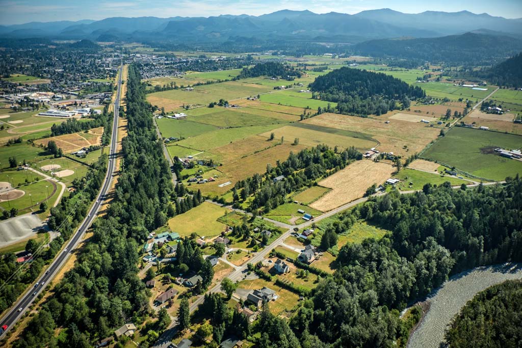
The Enumclaw Plateau is a relatively flat triangular plateau extending westward from Mount Rainier and the Cascade Mountains between the White and Green rivers in southeast King County. It is composed of fertile agricultural and forest cover. The City of Enumclaw is located at the plateau's southeast corner, the City of Auburn is northwest of the plateau, the City of Black Diamond is north of the plateau on the far side of the Green River Valley, and the Muckleshoot Indian Reservation is at the plateau's northwestern edge. The Enumclaw Plateau's farmland was formed approximately 5,600 years ago during the Osceola Mudflow. Originating from the summit of Mount Rainier, the massive landslide created impermeable soils that, once drained, left pasture suitable for agriculture.
In the millennia following the mudflow, populations of Native Americans settled near the river valleys on the forested plateau. When new non-Indian settlers began arriving in the 1850s, homesteaders established subsistence farms with outbuildings, orchards, and vegetable gardens across the plateau. Commercial hops farming became a specialty in certain areas, but an 1890 hops lice infestation devastated the crop and it was rarely farmed again on the plateau. Instead, dairying and berry production became widespread.
At the turn of the twentieth century, the agricultural industry was in high demand and homesteaders were found spread across the plateau. Subsistence farms became the minority, with farmers setting up specialized operations in dairying, berries, vegetables, or poultry. Dairying was the primary industry in the early 1900s, while chicken ranching flourished on the plateau after World War I. The agricultural landscape changed after 1960, when dairy operations everywhere were forced to expand to remain competitive. But on the plateau, instead of expanding the number of dairies decreased and much of the the land was subdivided for development, leaving it dotted with agriculture that had once blanketed the entire area.
Enumclaw Plateau Agricultural Production District
The decrease in agriculture on the Enumclaw Plateau was mirrored in the rest of King County (and all across the country), and that immense decline in the county's agriculture inspired efforts to preserve it, first through the 1979 Farmland Preservation Program and then the 1985 designation of five Agricultural Production Districts in which agriculture was deemed the preferred land use. The five districts were Snoqualmie Valley, Sammamish Valley, Lower Green River Valley, Upper Green River Valley, and Enumclaw Plateau, together totaling 41,000 acres of the last remaining clustered farmland in the county.
The Enumclaw Plateau Agricultural Production District is the largest of the five at more than 20,000 acres, holding nearly half their total land. Due to its plateau location, it has suffered less frequently from floods than the other four districts located in river valleys. Although it is the most rural of the districts, it has still faced urban tensions and challenges. The City of Enumclaw, for example, is largely surrounded by the farmland of the district. Similar to the plateau, the population of the city has grown exponentially since the mid 1980s.
Addressing Concerns
An analysis of the Enumclaw Plateau's existing conditions in a 2009 report raised some concerns about its future success. Although the majority of the district's land was being used for agriculture as the designation intended, only 26 percent of the land was owned by farmers and only 24 percent was formally preserved through the Farmland Preservation Program. Much of the farmland was simply being leased by farmers, with no assurance for future agricultural use of the land.
Another concern for the health of the agricultural district came from zoning restrictions that the county had actually intended to help preserve agricultural lands. Within the Agricultural Production Districts, King County required minimum lot sizes of either 10 or 35 acres, intending those lots for use in commercial farming operations. However larger parcels of land, even within the designated Enumclaw Plateau Agricultural Production District, were being subdivided to the minimum allowed size and sold as sites for grand country homes. Retirees or commuters to nearby cities developed rural homes on the plateau with amenities including horses, llamas, and emus, and gardens with scenic views of Mount Rainier. Although they still shared the plateau with more traditional farmers, if enough agricultural and grazing land were lost to this residential development, it would threaten the livelihood of those who depended on livestock and dairy farms.
Grazing lands were crucial to preserve on the plateau, as 40 percent of its total land use was livestock/forage and 18 percent was raising horses, each depending on availability of grazing areas. Approximately 18 percent of the district's landcover was steep vegetated slopes at the White and Green rivers' edges that were unsuitable for farming. A small percentage of the district, approximately six percent, was unmanaged grassland, which had potential to be used for agricultural production.
A trend, seen across the county, to smaller farms often brought additional need for second sources of income as the agricultural profits proved to be less than substantial for most. Small-acreage farmers pressed for the ability not just to harvest their land but also to process crops there. Wade Bennett of the plateau's Rockridge Orchards & Cidery wanted to bring customers to his 41-acre apple orchard not only to harvest apples but also to buy cider that he would be allowed to process onsite. The county recognized the importance of such urban and agricultural coexistence and changed zoning regulations to allow such operations and others for the mutual benefit of both urban and suburban dwellers and farmers in the Agricultural Production Districts. The county council approved Ordinance No. 16028, allowing onsite processing facilities in the districts, on March 3, 2008.
Food Revolution and Agritourism
King County was the fourth-fastest-growing county in the nation between July 2015 and July 2016, with people flocking to its urban centers. The "food revolution" was already booming with young and old alike, as eating, buying, and seeing local and organic food became increasingly popular. That revolution coincided with the shift toward smaller-acreage farms in the county's Agricultural Production Districts, allowing a focus on local retailers and farmers markets. Although the shift was apparent on the plateau, it was somewhat slower there than in the other districts because livestock/forage remained the Enumclaw Plateau APD's primary land use. In 2015, when the City of Enumclaw hoped to acquire some of the plateau's agricultural property for potential commercial development, farmer Leeann Krainick told the city council in response, "Dairy farming in Enumclaw and Washington state is alive and well" (Hanson).
Agritourism has increasingly become a means of supporting farmers and their work in the Agricultural Production Districts. The Sammamish Valley has a distinctive agritourism focus centered around winemaking, while the Enumclaw Plateau Agricultural Production District celebrates its Mount Rainier scenery and dairying past -- and present. King County cultural funding agency 4Culture established the Enumclaw Plateau Loop Tour, a bicycle or vehicular route around the agricultural lands to see working dairy landscapes and grand views of Mount Rainier, and appreciate historic vernacular structures from the early 1900s including barns, milk houses, a milking parlor, silos, and other dairy-related buildings.
