Entiat, the smallest incorporated municipality in Chelan County, is located on the west bank of the Columbia River, approximately halfway between Lake Chelan to the north and Wenatchee to the south. The Entiat Valley was difficult to reach and did not see permanent non-Native settlement until the late 1880s. Originally part of Okanogan County, in 1899 the region was included in the newly created Chelan County. Early settlers in the Entiat Valley relied primarily on logging, farming, and ranching. Aided by irrigation projects, fruit production soon became a primary economic activity. The Great Northern Railway bridged the Columbia River south of Wenatchee in 1892, and more than two decades later ran its line north along the river's west bank, securing Entiat's continued existence and at least modest prosperity. Perhaps uniquely, Entiat has had to move twice since its founding in the 1890s, forced first by fire and, 40 years later, by inundation when the Rocky Reach Dam was completed. The town's last move, in the early 1960s, presented unique challenges for the community. But its people persevered, and between 1970 and 2020 the town's population more than tripled.
The Land of the Entiat
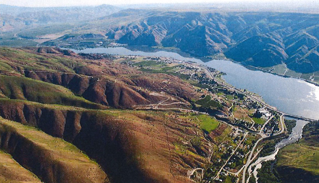
The Entiat River begins just below Mount Fernow's Entiat Glacier and flows approximately 50 miles to its confluence with the Columbia River. The terrain along the river's length ranges from a narrow, steep, glaciated valley in the upper reaches to a broader U-shaped valley through the middle and lower stretches. It was the homeland of the Entiat, one of the smallest tribes of several Salish-speaking groups that dwelled along the course of the Columbia in what is now Eastern Washington. The tribe's original name, Entiatqua, has been translated as both "rapid water" (Meany, 80) and "place of grassy water" (Bright, 145), although the first is most widely accepted.
Villages were the basic political units of the region's tribes, usually composed of related individuals and essentially autonomous. Bonds between villages and between tribes were strengthened by shared habitat, shared language, intermarriage, and similar customs and values. Although considered by some ethnographers to be a subdivision of the larger Wenatchi tribe, the Entiat appear to have been an independent entity, as evidenced by the mark of Lahompt (or La-Hoom), the son of Entiat chief Chilcosahaskt, on the 1855 Yakama Treaty.
That treaty was the first of several that the federal government imposed on the tribes living along the Columbia in Eastern Washington during the second half of the nineteenth century. A number of reservations were established, only to be later altered (almost always diminished) or rescinded. The paramount goal of treaty making was to segregate Indians into defined reservations, freeing up their homelands for non-Native settlers and the exploitation the region's abundant natural resources.
Of particular relevance to the Entiat Tribe, in 1879 the Moses Columbia Reservation was formed, with the canny Columbia chief, Moses (ca. 1829-1899) representing a confederacy of native groups that included the Entiat. In 1883, in an agreement between Moses and the federal government, the Moses Columbia Reservation ceased to exist. The following year Moses agreed to move with his people to the Colville Reservation, which had been created in 1872 by an executive order of President Ulysses S. Grant (1822-1885). Today 12 tribes, including the Wenatchi, Chelan, and Entiat, comprise the Federated Tribes of the Colville Reservation.
Some Indians refused to leave their traditional areas, instead claiming allotments of land where their forebears had lived, a "privilege" granted to some who had been living on the Moses Columbia Reservation. Included among these were the Entiat chief, Chilcosahaskt, who homesteaded land at the mouth of the Entiat River, and N'k'whilekin (1825-1911), known to white settlers as Wapato John, who settled on Lake Chelan. Chilcosahaskt and Wapato John were half-brothers, sharing a mother, Ken-em-tiq't, a Skokomish from west of the Cascades. Wapato John's first wife, Timish, died after the birth of their son, Charles, and he then married her older sister, Smee-mee-hulks (Madeline).
Chilcosahaskt was the third of that name to lead his tribe, and he lived his entire life on or near the Entiat River. Non-Native settlers had difficulty pronouncing many Indian names and called him Silico Saska. Several historians accept that the chief was born in 1788, and he died in 1903. If the year of his birth is accurate, he had a remarkable lifespan of approximately 116 years. The first town to be called Entiat was built on land Chilcosahaskt had owned, and years after his death his relatives almost ended up owning the site of the second.
A Hard Place to Get To
The country along the west bank of the Columbia River from Lake Chelan south to the Wenatchee River was difficult to reach, hemmed in by mountains on the north, south, and west, and with access from the east hampered by the hazards of the Columbia River. Some trappers and explorers ventured through in the first half of the nineteenth century, and in the 1860s and 1870s Chinese miners were working placer operations on the region's rivers. In 1868 two travelers from what is now Ellensburg encountered a dark-skinned man called Big Antoine, possibly a former employee of the Hudson's Bay Company and of Hawaiian origin, washing for gold near the Entiat River. He had planted peach trees near his claim, the first documented cultivation of tree fruit in the valley. Chilcosahaskt, who did not then accept non-Native settlement, had him ejected in 1879 or 1880 by the commandant of a short-lived army camp at Lake Chelan. With the exception of a scattering of Chinese miners and Big Antoine, it appears that until the mid-1880s the region was inhabited exclusively by several Indian tribes, notably the Wenatchi, Entiat, Columbia, and Chelan.
The non-Native history of Entiat properly begins in Douglas County, where in 1887 Dr. John Brown Smith (1837-1917) filed the first plat for the town of Orondo on the opposite (east) bank of the Columbia. As one history, published in 1929, notes, "Orondo was the gateway to the Entiat Valley, and in many respects both places are so inseparably linked that ... they may be regarded as one community" (Hull, 408). Orondo was the supply and marketing center for Entiat's earliest settlers, and most who lived in the region assumed that when the railroad inevitably worked its way west from Spokane, it would run along the east bank of the Columbia River and pass through Orondo, all but guaranteeing its prosperity. It was not to be.
Dr. Smith enjoyed good relations with Chilcosahaskt and his people, and they would ferry him by canoe across the turbulent Columbia to explore the Entiat Valley and do some prospecting. Smith realized the potential of the fertile lower valley and later would recommend it to new settlers arriving in the region.
A Somewhat Rocky Start
Interestingly, the first log house in Entiat of the sort that early homesteaders would build belonged to Chilcosahaskt. In 1886, a year before the arrival of the first non-Native settlers, he hired William Sanders (1861-1908) and Henry Domke, who earlier that year had become the first white settlers on Lake Chelan, to build it for him.
Published histories vary somewhat on the precise chronology, but are in agreement that the first white settlers in the Entiat Valley were Lewis Detwiler (1850-?), a bachelor, and his brother John, who was married and had one child. Lewis Detwiler was well-traveled, having lived in Wisconsin, Kansas, Wyoming, and Montana before arriving in Douglas County in 1883 and claiming a homestead south of Orondo. In 1887 Detwiler sold that property, built a large rowboat with his brother, and moved all their possessions across the Columbia. John Detwiler claimed a homestead near the mouth of the Entiat River; Lewis settled about three miles upriver in the lower Entiat Valley.
Although Chilcosahaskt had good relations with Orondo's Dr. Smith and with Chelan's Sanders and Domke, his attitude changed when the Detwilers settled on land the chief considered his. When Lewis Detwiler first arrived, Chilcosahaskt confronted him on the bank of the Columbia, and after Detwiler had settled on his homestead upriver, the chief and one of his his sons, armed, tried to scare him off. Somehow violence was avoided. Detwiler appealed to David Freer (1836-1888), who was married to one of Chilcosahaskt's daughters, to intervene. He did, and the chief was persuaded to leave Detwiler alone.
But Chilcosahaskt was not yet accepting of interlopers, and he next turned his sights on James C. Bonar (1829-1892), who arrived shortly after the Detwilers in 1887 and settled about a mile up the river. The harassment carried over into the early summer of 1888, when Thomas J. Cannon (1856-1925), an ordained minister, arrived with his wife, Sarah (1834-1936). The Entiat regarded Cannon as a holy man and trusted him. (Chilcosahaskt had been exposed to Catholic theology in 1874 by Father Urban Grassi, who had started a mission among the Wenatchi Tribe.) Cannon explained the requirements of treaty agreements to Chilcosahaskt and the need to abide by them. The confrontations stopped and were not renewed. On September 4, 1888, Bonar noted in his diary, "Found in Rev. T. J. Cannon a friend of no ordinary kind, for which he will ever be greatly esteemed" (Hull, 418). In 1889 Cannon established the first water-powered sawmill on the Entiat River, and he built the community's first frame house. The Cannons' daughter, Dema, was the first white child born in the Entiat Valley.
Things Settle Down
John Detwiler and his family left the area within a year, but Lewis Detwiler farmed his homestead for about a decade. In 1898 he traded it to another early settler, Frank E. Knapp (1868-1931), for a Columbia River ferry that Knapp had established to the north of the Entiat River. Detwiler would run it for a few years before moving on again, this time to California, where his trail grows cold. With his departure, the family of James Bonar, who had died several years earlier, took pride of place as the first permanent non-Native settlers in the Entiat Valley.
In 1888, just one year after the Detwilers arrived in Entiat, steam-powered sternwheelers began regular runs up the Columbia River, from Wenatchee all the way to Brewster, approximately 60 river miles to the northeast. These boats, which could carry more than 100 passengers and tons of freight, made a stop at a sand bar just north of the mouth of the Entiat River. The Entiat Rapids, just south of the river's mouth, presented a particular challenge. Cables were anchored along the river bank and used to winch the steamboats upstream to stiller waters. Even so, at least four large sternwheelers and their cargos were lost, but with only a single loss of life. The last to sink was the sternwheeler Pringle in 1907; later that same year, crews led by Major Hiram M. Chittenden (1858-1917), who later would play a key role in the development of the Lake Washington Ship Canal, began taming the rapids by clearing the rocks with explosives.
The sternwheelers from Wenatchee were a boon to freight traffic, but it was to Orondo, and to Waterville about eight miles farther east, that Entiat's early settlers went for supplies, mail, schooling, and socializing. In the earliest days it was often Silhohsaskt, fully versed in the hazards of the Columbia River, who ferried people across in his dugout canoe.
The years following the arrival of the Detwilers, Bonars, and Cannons saw a slow but steady increase in non-Native settlement on and near the Entiat River. Most of the new arrivals settled in the valley, and some ventured more than 20 miles upriver. By mid-1894 the total non-Native population of the Entiat country was 80, of whom about 20 percent were bachelors. By this time Chilcosahaskt had come to accept their presence, and one history notes that he was "naturally of a good disposition, although the same cannot be said of his wife" (Hull, 445).
The First Town of Entiat
It is difficult to pin down precisely when the first town of Entiat was established, in part because there is no evidence that any formal plat was recorded. Most sources place the founding of the town in 1897, when what is now Chelan County was still part of Okanogan County, but there is no township plat to be found in the records of the Okanogan County Auditor.
This much can be said with some confidence: In 1896 or 1897 John G. Ely (1837-1915), who had come to the Entiat Valley from Iowa in 1895 to farm, bought a site from Chilcosahaskt that was located on the north bank of the Entiat River, about one-half mile west of its confluence with the Columbia. There, in 1897, Ely opened a store and a hotel, and this is credited by historians as the origin of the town of Entiat. In that same year a wagon road was completed between Wenatchee and Twisp, passing through Entiat and easing its isolation.
In 1899 (some sources say 1901) Charles C. King (1859-1938), who had volunteered to be Entiat's first postmaster, built a second store, which also housed the post office. There soon followed a confectionary store, a gathering place called Jinkin's Hall, the Blind Pig Tavern, and a barber shop.
Water for Entiat came not from the river, but from a spring to the north of the townsite. As more settlers arrived, other needs were met. A Christian Church was built in 1902, a Quaker Church came in 1906, and the First Presbyterian Church was established in 1913. The town's first school (although not the first in the valley), named the Harris School after its first teacher, was opened in 1899, and its small building was expanded in 1905 to accommodate a high school. It was also in 1899, on March 13, that Chelan County was created by the state legislature from parts of Okanogan County to the north and Kittitas County to the south. The first recorded plat for Entiat that can be located in Chelan County records was filed in 1905. It was titled "Millside Addition," leaving unanswered the question of what earlier plat, if any, it was an addition to.
In 1906 the Entiat Telephone and Telegraph Company was incorporated by Frank E. Knapp and two partners, and by 1908 its lines ran 15 miles up the Entiat Valley. Also in 1908, Charles A. Harris and J. E. Stout started constructing the Entiat Light and Power Company plant, spinning its turbines with water diverted from the Entiat River about a mile and a half up from its mouth. It went online in 1910, and although service could be erratic at times, the plant provided electricity not just to Entiat, but to Orondo, Waterville, and Wenatchee as well. In 1913 Edward P. Murphy (1878-1946) issued the community's first newspaper, the Entiat Times.
The Second Town of Entiat
This first town to be called Entiat grew slowly, but had two failings -- it was not directly on the planned route of the Great Northern Railway, and it had an inordinate susceptibility to fires.
In 1892, to the chagrin of Orondo and other nearby towns on the east bank of the Columbia River, the Great Northern Railway built a bridge to cross the river at Rock Island, about 10 miles south of today's Wenatchee. This made it clear that if any riverside towns were to be served by the railroad, they would be on its west bank.
The first priority of the Great Northern's president, James J. Hill (1838-1916), was to push his line over the Cascade Mountains to Seattle and become the nation's first transcontinental railroad to be built without government subsidies. By June 1893 he had succeeded, but it would be two decades before rails would reach the Columbia River towns north of Wenatchee. In 1912, as the population in the region increased and its fruit industry expanded, the Great Northern began surveying a route that would carry the railroad to as far north as Oroville near the Canadian border. One surveyors' camp was established at Entiat.
In anticipation of the coming of the railroad, in 1909 Charles Gray (1867-1958) of Entiat, joined by James Kennedy of Waterville and George Brown of Chelan Falls, purchased land that ran north from the mouth of the Entiat River along the west bank of the Columbia River. They founded the Entiat Townsite Company and, under the name Entiat Delta Orchards Corporation, platted the land into town lots and five- and 10-acre parcels, setting aside 21 acres for the Great Northern to build a depot and side tracks, and for warehouse sites.
In 1912 a fire destroyed the sawmill that had been started by Thomas Cannon in 1889 and was at the time of the fire owned by Gray. The loss was total, but partially insured, and the sawmill was back in business the following year. But even before a second fire destroyed much of the first town of Entiat in October 1915, the smart money was moving to the new townsite along the Columbia. (The 1915 fire destroyed the Harris School, several businesses, and, for the second time, Gray's mill. Only six structures survived, and they were destroyed in 1921 by yet another fire.)
The railroad finally reached Entiat in July 1914, and the town's future seemed bright. But there was a lingering problem -- heirs of Chief Chilcosahaskt were pursuing a claim that much of the land upon which the second Entiat sat belonged to them, and not to the Entiat Townsite Company.
Who Owns Entiat?
The opinion in Entiat Delta Orchards Co. v. Unknown Heirs of Saska, rendered by the Washington State Supreme Court in November 1917, traces the convoluted history of disputes over the ownership of Entiat's land. Happily, only the final act need be briefly summarized here.
In accordance with one federal homestead law, in 1896 Chilcosahaskt was granted what was called a trust patent for 146 1/4 acres, land he had resided on for decades. Under that grant, the federal government would hold title to the land "in trust" for 25 years, meaning that the chief would not be free to sell it without permission until 1921. However, in 1902 Chilcosahaskt, at his request and pursuant to another statute, was granted a patent-in-fee to the land, which gave him full and clear title and the legal right to dispose of it when and as he wished. The chief died on February 10, 1903, and on June 1 his estate administrator sold the land to members of the pioneering Bonar family. It then passed through other hands until, in January 1909, it was purchased by the Entiat Townsite Company.
Chilcosahaskt's heirs sued, arguing that the issuance of the patent-in-fee was in error and perhaps fraudulent, that the trust patent remained in effect, and that the sale of the land to the Bonars was therefore void, which would invalidate all subsequent sales. The Chelan County Superior Court (with a King County judge presiding) agreed, and awarded a portion of the land to the chief's heirs, causing much consternation to the non-Natives in the area. Delta Orchards appealed, and on November 22, 1917, the state supreme court overturned the lower-court decision and quieted title in the town's developers.
Entiat was now free to grow, and it would, if slowly. But four decades later, events that were unforeseeable for most of the town's existence would force its people to pull up stakes and move again.
Entiat's Economy
The challenges faced by early settlers struggling to create communities in the wilderness is usually fodder for the most compelling stories about the history of small towns, and Entiat is no different. After its first relocation, the town grew slowly. Entiat's first significant industries were logging trees and milling lumber, and at various times there were up to 11 mills operating in the drainage basin of the Entiat River, the timber used for homes, commercial buildings, fruit boxes, irrigation flumes, and railroad ties. (Entiat's last lumber mill operated until 1979.)
In the late 1800s and early 1900s, the high open range around the Entiat and Mad rivers was prime grazing land for sheep, and later for cattle and horses. At one point more than 13,000 sheep in eight bands were counted in the area, but the industry was greatly diminished by drought, the Great Depression, wartime labor shortages, and changing tastes.
One activity above all would sustain Entiat for decades -- the cultivation of tree fruit. Chief Chilcosahaskt had kept several of Big Antoine's peach trees, and in 1893 William F. Cannon (1854-1928) planted the valley's first commercial orchard. Others soon followed. The earliest crop was a wide variety of apples, which the homesteaders would pick, sort, pack, and send off to market. Dedicated packing sheds and warehouses sprouted up, and when the railroad came through in 1914 fruit warehouses and cold-storage facilities were built adjacent to the tracks. The 250-acres Keystone Ranch, part of which was James Bonar's original homestead, was founded in 1910 and grew and marketed under its own label several varieties of apples, along with pears and Elberta peaches.
One More Move
Entiat officially incorporated as a fourth-class municipality (town) on April 17, 1944. Ten years earlier, and perhaps unbeknownst to its citizens, a section of the Columbia River known as Rocky Reach, about nine miles south of the mouth of the Entiat River, had been identified by the U.S. Army Corps of Engineers as a potential site for a dam that could supply both electrical power and irrigation. After years of planning and preparation, construction of the Rocky Reach Dam began under the auspices of the Chelan County Public Works Department (PUD) on October 2, 1956.
When the dam was complete, the site of the second town of Entiat, which had grown up along the Columbia's shore just north of the mouth of the Entiat River, would be inundated by the resulting reservoir, named Lake Entiat. When filled the lake would be 43 miles in length and encompass 9,100 acres. Little more than 40 years after its previous move, Entiat would once again have to relocate, and this time it would be both more complicated and beset by controversy.
Work on the Rocky Reach Dam started in 1956, but was not scheduled to end until 1962, when the reservoir would be filled. The Chelan PUD bought out the property owners in Entiat whose land would be inundated and worked with local developers to plan a new townsite. This is where the problems began. There were inevitable disagreements over the value of the properties, and disputes about the location of a new commercial district. As a result, many businesses either did not reopen or moved to other communities, and those that did reopen clustered in two separate business areas -- this in a town of only 357 people (1960). Only one commercial building, the Oddfellows Hall, was moved to the new townsite, and only three of the town's several fruit warehouses were rebuilt there. Some private homes were moved to higher ground behind the second Entiat, or north to the new townsite, and the remaining buildings in the old town were razed or burned. It was a difficult time, as one local historian summed up: "The moving of the town has changed the fabric of life ... In one large sweep of change, the economic basis, the identity of a community, and the sense of belonging were gone" (Griffith, 91).
Entiat would survive, although its recovery would be slow. Lake Entiat provides recreational opportunities that the untamed Columbia could not, and while many older residents moved away in the 1960s, many of the younger generations stayed. By 2020 Entiat's population had grown to 1,290, more than three times the 1960 figure, and the town could declare, "The identity of the community and a sense of belonging has returned to Entiat and will continue to thrive due to the heart and stamina of its residents" ("Third Town").
