When Waterfront Park opened in 1974, it was the first public park on Seattle's central waterfront, an area that had long been used for work and play, but never had a designated public recreational space. The park was developed in the early '70s at a turning point in the waterfront's history, as shipping and industry shifted to the northern and southern ends of Elliott Bay and not long after the Alaskan Way Viaduct created a barrier between downtown and the shoreline. Waterfront Park was part of a larger effort to transform the waterfront into a tourist destination and to revitalize the central business district. After a contentious design process, the park, which provided public access to the water and space for public programs, opened to mixed reviews. The Seattle Aquarium, which opened in 1977, sits on the northern side of the park and Pier 56, a transit shed converted into restaurants and shops, forms the southern side. The industrial character of the park's design, intended to honor the working waterfront and Pier 58's past as a shipping terminal, did not entirely succeed as its designers had intended, and the park was removed for redevelopment in 2020.
A Place for Work and Play
The central waterfront has been a place where people work and play for as long as humans have lived on Elliott Bay. Duwamish people used the beach for gathering plants and shellfish and fishing for a variety of species, and it was a place for gathering with other Coast Salish people from around the region. These gatherings often featured canoe races and rousing games of slahal, a gambling game.
After non-Native settlers began building piers and mills along the Seattle waterfront, the newcomers also came to the beach to play. When James Colman (1832-1906) towed the hobbled bark Windward to the foot of Columbia Street to serve as a breakwater, local children used it as a swimming dock. The shipping piers served as ad hoc fishing, squidding, and crabbing docks.
After the 1897 Klondike Gold Rush led to exponential and unmanaged growth in Seattle, civic leaders initiated the city's first urban planning in the form of the Olmsted Brothers' 1903 park system plan. John Olmsted (1852-1920) recommended several parks along the waterfront, but their realization was thwarted by competition for space because the bluffs surrounding the bay concentrated development right along the shoreline. When the Municipal Plans Commission hired Virgil Bogue (1846-1916) to develop a city plan, he incorporated Olmsted's shoreline parks concept in his Plan of Seattle, completed in 1911. It included a water gate at the foot of Broad Street, which led to the planned civic center. Bogue's plan failed at the polls in 1912, however, and the first city zoning in the 1920s gave the entire waterfront over to manufacturing.
The emphasis on a working central waterfront shifted in the post-war era, as port activities moved to the north and south ends of Elliott Bay and the Duwamish Waterway. As ships grew larger and cargo volumes increased, shipping companies needed more room for cargo handling and larger berths. This trend accelerated as container shipping was adopted, first by the Alaska and Hawaii trade and then nearly universally. At the same time, passenger traffic through the central waterfront decreased as automobiles and freeways supplanted marine transportation systems.
Seattle got a taste of the potential for tourism development in 1962, when several attractions and businesses opened on the waterfront's piers in time for Century 21, the world's fair held at Seattle Center. Trident Imports, a large retail shop, and Peter Griffith's aquarium opened at Pier 56 in 1962. The Edgewater Hotel on Pier 67 opened in time to help house fair visitors. These new establishments, along with existing restaurants such as the Polynesian and Ivar's, showed the potential uses of the piers and the barn-like transit sheds atop them.
Visions of a Park
In the mid-1960s, the pace of change increased, according to Caroline Tobin's study of central waterfront planning and, "the concept of a park began to be taken seriously ... it was touted as the cornerstone for future redevelopment of an outmoded, deteriorating waterfront" (Tobin, 21). The first official city plan to address redeveloping the waterfront was Donald Monson's "Comprehensive Plan for the Central Business District," commissioned by the City of Seattle and Central Association in February 1963. Monson's plan, best known for calling for the demolition of Pike Place Market, recommended that the waterfront be made into the city's "front porch" and better connect with downtown and a soon-to-be-redeveloped Pike Place Market.
To further develop plans for the waterfront, the city, the Port of Seattle, and private pier owners hired John Graham and Company. The 1965 Graham plan incorporated Monson's suggestions for improving connectivity with downtown, utilizing a mix of public and private investment. The recreational element stretched from Madison Street to just north of Pike Street. It included a small-boat basin, aquarium, motel, heliport, and a park along the western, water-facing side. A gondola-like cableway with terminals at the waterfront and at Pike Place Market would help visitors traverse the steep hillside and pass over the railroad tracks and Alaskan Way Viaduct.
While these planning processes continued, civic leaders and community members across King County campaigned for passage of the Forward Thrust propositions. Proposition 6 would authorize a bond issue of $188 million for parks and recreation in King County. The waterfront park was earmarked for $5 million of this funding. Graham's plan informed the park proposal, including its location between piers 50 and 63. The plan recommended solutions to historic problems with circulation (automobile, railroad, marine traffic, public transit, and pedestrian) and parking along the waterfront, as well as environmental issues such as visual barriers, noise, air and water pollution, and obsolete piers and structures. The parks proposition passed easily in March 1968, and the city hired George T. Rockrise & Associates the following fall to study the waterfront and prepare a development plan using the Monson and Graham plans for guidance.
The park bond specified a waterfront park, encompassing 15 acres, but did not provide further guidance about the location or design of the park. To provide this guidance, Mayor James D. Braman (1901-1980) appointed an advisory group to work with the Rockrise team of planners. The Mayor's Waterfront Advisory Committee included community members with economic interests on the waterfront, such as local businessowners, an executive from the Northern Pacific Railroad, and a leader of the Central Association (the downtown business association). The Waterfront Advisory group presented its work to the public in December 1969 and it was not well-received. Critics claimed it reflected only the interests of a small part of the city and largely maintained the status quo on the waterfront.
Community Involvement
Community interest in the waterfront and city planning decisions had grown during the 1960s. Having been through contentious battles over the R. H. Thomson Expressway, Interstate 5, and State Route 520 routing and construction, as well as the threat posed by urban renewal plans for Pike Place Market and Pioneer Square, community activists demanded a new advisory committee and a revised study.
To that end, the newly elected mayor, Wes Uhlman (b. 1935), appointed a new advisory group, the Citizens Waterfront Task Force. This group, comprised of a broad cross-section of the city, including a newspaper editor, a Chinatown-International District restaurant owner, an architect-urban designer, a professor of urban design, a Park Commissioner, a Design Commission member, a graduate student, a fisherman, a Boeing engineer who was also president of Citizens Against Freeways, a union leader, and the Seattle Indian Health Center director. While this was not the first citizen advisory committee in Seattle, it was one of the most prominent of the early committees and represented the city's move away from mayoral advisory committees and toward a more community-based process that forms a key element of city government today.
The Citizens Waterfront Task Force discussed how the park should relate to the private businesses along the waterfront, most importantly on the privately owned piers adjacent to the park area. Some members of the committee wanted the park to extend inland and out over the water to create an oasis of open space in the midst of the working waterfront. Others felt it should be more linear, focusing primarily on a promenade along the privately-owned piers.
The city's new Department of Community Development held a series of public meetings in early 1970 at the Seattle Center and the University of Washington. It gathered comments from the public about the waterfront and how people wanted to see the park developed. In January 1971, Rockrise released a revised report that represented the views of a broader range of the city's residents. In recognition of the park's historical context, the study recommended that the park embrace its urban, quasi-industrial surroundings rather than attempt to create a pastoral green space, and emphasized public access to the water and views.
The location of the park, at what had been Pier 58, connected it directly with two significant events in Seattle history in the 1890s. In 1896, the Miike Maru docked at what was then-known as the Schwabacher Pier, marking the start of regular, trans-Pacific shipping between North America and Japan. The next year, the docking of the Portland with a "ton of gold" from the Klondike launched the Klondike Gold Rush—kicking off more than a decade of economic development and drawing a massive influx of new residents to Seattle. In 1965, the pier had to be demolished because of its deteriorated condition.
Central Jewel of an 'Entertainment Crescent'
The Rockrise report, The Seattle Central Waterfront: A Study for is Future Comprehensive Development, laid out a vision for the park and the surrounding neighborhoods. James D. Braman Jr., Director of the Department of Community Development, wrote a forward in which he laid out the broader vision underlying the effort to revitalize the waterfront: "The waterfront park will be the central jewel in a necklace of entertainment-oriented activities extending from the south end of Lake Union, through Seattle Center, all along our central waterfront, and into Pioneer Square and the International District. This 'fun strip' will contribute much to the enjoyment of living in Seattle, and will greatly strengthen tourism as an important business in the region" (The Seattle Central Waterfront).
The planned park extended from the water surface onto the upland and across the Alaskan Way right-of-way. At the water level, a floating breakwater that park users could traverse and a 300-berth marina provided access to the water in a way that was not possible elsewhere on the central waterfront. On the upland side a promenade, in the form of a wide walkway and plantings, extended the park to the north and south. A pedestrian bridge connected the park to the ferry terminal at Pier 52.
Beyond the park's boundaries, the Rockrise report encouraged the city to create a new design district with limits on the height and bulk of buildings and encourage tourism-retail development to the east of the concessions center at Pier 56. It segmented the uses on the piers, with new tourist and water-oriented development slated for piers 50 and 51, and maritime commerce on piers 64, 65, and 66 (which included Port of Seattle facilities). On the inland side of Alaskan Way between piers 60 and 66, the plan prescribed multi-use development, including hotels, apartments, tourist retail, and a parking garage.
To create a new environment on the waterfront, the Rockrise report identified uses that should be encouraged and others that should be excluded. The acceptable uses included central business district services (such as the steam plant at Western Avenue and Union Street), offices, the ferry terminal, the fireboat station, restaurants, retail tourist shops, port offices, and tour boat facilities. New uses that would complement the plan included marine retail, cruise ship terminals, an historic ships display, a maritime museum, and hotels and apartments on the inland side of Alaskan Way. Light industry, such as fish processing, and parking facilities would be relegated to the northern end of the waterfront.
Because the waterfront was an important east-west and north-south transportation corridor, the Rockrise team addressed circulation in the area as part of its plan. It recommended all railroad traffic be moved from the tracks paralleling Alaskan Way south of Pike Street to the tunnel under downtown. To reduce vehicular traffic, the plan called for cars and trucks to be shifted to Western Avenue and only public transit allowed on Alaskan Way. Although some people had called for the removal of the Alaskan Way Viaduct because of the noise, visual blight, and the perceived obstacle it posed to east-west travel, the Rockrise team recommended that it be "visually and acoustically improved," but not torn down until it was no longer useful for carrying traffic north and south.
As part of the effort to build connections between Seattle Center, the waterfront, Pike Place Market, and Pioneer Square, the arc of attractions labeled the "Entertainment Crescent," they recommended the introduction of a shuttle bus. To facilitate pedestrian movement between the waterfront and the central business district, they recommended installation of a moving walkway up the hill from the waterfront.
The report integrated public and private improvements into the plan. It called for linear extension of the park in the public right-away on University, Marion, and Union streets inland from Alaskan Way and then up Western Avenue and inland again on Lenora Street. At Columbia, Madison, Seneca, and Union streets, portions of the privately held land could be landscaped to provide extensions of the park experience. This vision would be realized, to a degree, at Harbor Steps, Pike Place Hillclimb, and the Union Street stairway between Western and First avenues.
This report was favorably received by the public and work proceeded on the first phase, the waterfront park stretching from Pier 55 to Pier 61. In June 1971 a local architecture firm, The Bumgardner Partnership, led by Albert O. Bumgardner (1923-1987), was hired to design the park. At the end of the year, it presented its plan to the city's Design Commission, the Board of Park Commissioners, Mayor Uhlman, and the city council.
The Final Plan
The plan had three primary elements. First, the designers decided to adapt the piers and transit sheds that remained instead of clearing them out for redevelopment because the design team "[realized] that there have always been a variety of activities on the waterfront ... Compartmentalization had never been a feature there" so it would be good to leave space for commercial enterprises (Lane, "Waterfront Park Shaped by History"). The designers also wanted to retain the visual effect of the barn-like transit sheds along the shoreline, at the base of the hill.
Second, they planned to integrate the water closely with the park design. Elevated walkways over the water would connect the outer ends of the piers. At the ends of the piers, the public could enjoy views out over the water and visit the glass-enclosed gallery planned for the end of Pier 57. At the water level, they planned a string of floating docks that would form a walkway between piers 57, 58, and 59. Third, they laid out the pedestrian promenade along Alaskan Way.
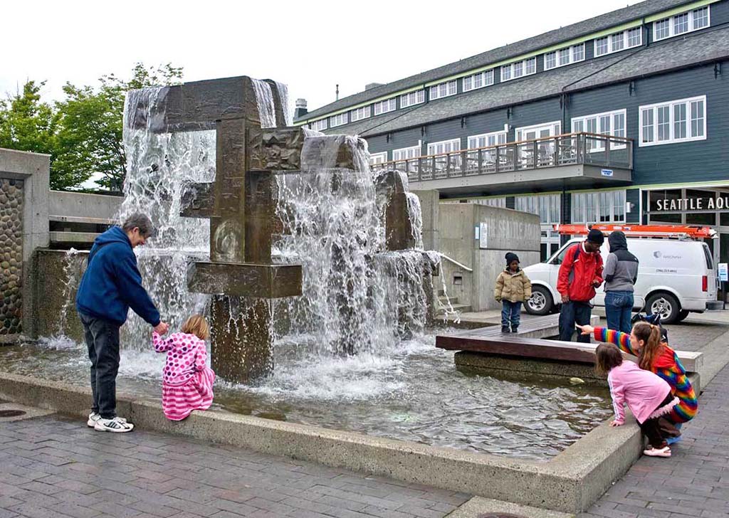
The center of the park, the new Pier 58, featured a wooden deck atop pilings above the water, but situated several feet lower than Alaskan Way. It served as an intermediate step between the streetscape and the marine level. Part of the pier had trees planted to create a buffer from the traffic of the street. A multi-layered concrete structure around a fountain created spaces for seating and plantings. They expected that the park would be surrounded by a museum on Pier 59 and the concessions and retail shops in Pier 57. Piers 60 and 61 were reserved for water-related attractions. At that time, the Seattle Aquarium was still slated for development at Golden Gardens Park in Ballard, but it would be moved downtown to Pier 59, where it opened to the public in 1977.
To accommodate the esplanade, Seattle Parks and Recreation requested a vacation of the sidewalk and parking lane adjacent to the park. This created space for a row of trees along the edge of the promenade between the planned Seattle Aquarium at Pier 59 and the ferry terminal at Pier 49 that would further muffle traffic noises from Alaskan Way.
Not all the elements that Bumgardner's team wanted to see in the park proved feasible. The elevated walkways across the open water were shortened to two ramps jutting up above the parks northern and southern arms at the request of the Design Commission. The Bumgardner Partnership altered the design so that at the top of each ramp was a viewing platform. The string of floating docks was also cut, partially out of concern that the 17-foot water level change with tides would be too difficult to accommodate and partially because of unexpected expenses related to property ownership at the time of the park's development. Pier 56 remained private property, so the over-water elevated walkway to the ferry terminal was never built.
The final park plans extended only from Pier 57 to Pier 59. Negotiations to acquire the larger area originally planned for the park, from Pier 55 to Pier 61, faltered when the private owner of piers 55 and 56 would not lower the price for those properties.
In addition to the landscape elements, one piece of public art was installed at the park. Helen Harrington Schiff commissioned artist James FitzGerald (1910-1973) to create a fountain in memory of Schiff's parents Edward M. and Margaret J. Harrington, and the city accepted the piece for inclusion in the park. FitzGerald died before completing Waterfront Fountain, but his wife Margaret Tomkins (1916-2002), also a sculptor, and Terry Copple (1945-1996), his assistant, completed the massive cast bronze fountain, measuring 16 1/2 feet tall and 21 feet wide. It was installed in the fall of 1974.
Opening to Mixed Reviews
When the park opened on October 25, 1974, it was met with mixed opinions. John Hinterberger wrote an amusing but scathing report in The Seattle Times, mentioning each speaker and entertainer, followed by a description of what kind of noise drowned them out. According to Hinterberger, the Seattle Parks and Recreation project manager, the mayor, Bumgardner, a park commissioner, and others could not be heard over a Burlington Northern freight train, a dump truck lumbering by on the Alaskan Way Viaduct, a semi-truck on Alaskan Way, the Walla Walla ferry coming into Colman Dock and the Yakima departing, a cement truck, and finally, another freight train. The weather in October was less-than-optimal for standing on a dock at the water's edge.
A fisherman Hinterberger quoted captured the real ambivalence Seattleites felt about the park: "'I guess I don't understand this park,' mused the pot-bellied fisherman at the end of Pier 57" (Hinterberger). The decision to eschew traditional park features such as lawns and trees in favor or hardscapes that echoed the industrial, maritime history of the site resulted in a park that was hardly like a park, at least in the popular imagination.
Another element of the ambivalence toward the park may have had its roots in a more generalized ambivalence toward a tourist-oriented waterfront. While shipping had largely moved out of the central waterfront, other light industry remained, including a number of fish processors and related businesses. In the 1980s, Mayor Charles Royer's administration developed the Harborfront Plan, which intended to address the district-wide circulation, economic development, and tourism facility recommendations of the Rockrise report. When the Harborfront plan was taken to the public, there was an organized opposition to abandoning investment in a working waterfront. An editorial in the Seattle Post-Intelligencer concluded that, "Despite the efforts of a small band of active dissenters, it seems inevitable that the style of Seattle's central waterfront soon will change from blue denim to silk" ("City Waterfront ...").
Not long after the park opened, a second sculpture was installed. With money raised by Seattle's Italian American community, Douglas Bennett (1920-2010) was commissioned to create a sculpture of Christopher Columbus. Seattle Parks and Recreation generally discourages memorials from being placed in public parks and the city's Design Commission objected to its unusual style, but mayor Uhlman and the city council overrode these concerns and the sculpture was installed in 1978. It was significantly damaged and finally removed in 2013 after years of attacks by vandals on the annual commemoration of Columbus Day.
Over its 44-year existence, Waterfront Park played a significant role in the life of the city, providing space to gather, celebrate, play, and commemorate. One of the longest-running annual events is Salmon Homecoming, a collaborative program of the Northwest Indian Fisheries Commission and the Seattle Aquarium, with the support of local tribes that has been organized by the Salmon Homecoming Alliance since 1999. Events held during the September celebration include educational programs for students, pow wows with dancing competitions, salmon bakes, canoe-welcoming ceremonies, and other activities to help introduce the larger community to Native cultural traditions.
There have been other annual programs. For many years in the 1980s and 1990s, the park was the site of Memorial Day services. Maritime Fest and Seafair festivities have made use of Pier 58's moorage for visiting ships, and the Christmas Boat Parade stopped at the park during the years it was held on Elliott Bay. For years, the park was the starting point or destination for parades and the site of memorial services and rallies. In August 1977, a march for women's rights and in support of passage of the Equal Rights Amendment started at the Federal Building and ended at the park. A march against police violence started at the park in October 1978. The next spring, in May 1979, a rally for Indian fishing rights organized by the Seattle chapter of the Native American Solidarity Committee was held there. A month later, supporters of a boycott of fuel companies rallied. The Peace and Disarmament Task Force of the Catholic Archdiocese of Seattle organized a Good Friday service at the park in April 1980.
Reimagining Waterfront Park
After the 2001 Nisqually Earthquake triggered the replacement the Alaskan Way Viaduct, Waterfront Park was included in the planning process that ensued. This appeared to be a new opportunity to address the larger issues of circulation and connectivity with the central business district and noise pollution (the trains had been rerouted through the train tunnel in 1986). Once again, a design firm was brought in to make a plan for waterfront redevelopment, this time James Corner Field Operations, based in New York City, working with a number of local landscape architects, architects, and engineers.
In the new plan, anchored in waterfront history, the historic piers 57 and 59 that are adjacent to Waterfront Park will largely be preserved, but the park will be entirely redeveloped. The new plan includes a new triangular pier, public art, open space for events, seating, and views across the water. One of the public art installations will be three welcome figures, collectively titled Family, to be created by artist Qwalsius-Shaun Peterson (b. 1975) of the Puyallup Tribe. Much of the new park will echo the hardscape of the old Waterfront Park, except for a small lawn area and significantly more plants and trees on the pier and in the upland area.
The FitzGerald/Tomkins Waterfront Fountain was intended to be refurbished and reinstalled in the new park, but, on September 13, 2020, Pier 58, which had started to shift in August, collapsed as the demolition crew worked to separate the fountain structure from the concrete surrounding it. The fountain, along with the northeast corner of the pier, fell into Elliott Bay. It will be incorporated into the new park, which is scheduled to open in 2025.
