Located just East of Interstate 5 as one enters Marysville from the south, the Qwuloolt Estuary serves as a model for Tribal-led multigovernmental habitat restoration. From conception to completion, the project took a little over 20 years of careful community education and engagement to succeed. At a cost of $20.5 million, 315 acres of Snohomish River floodplain were returned to as close to their original state as possible. This process required multiple phases of land acquisition, clean up, stream restoration and even relocation, and levee construction before the eventual 2015 levee breach flooded the former agricultural land.
Native Stewardship
The land that is currently known as Marysville has been the ancestral land of Coast Salish peoples for thousands of years; these are the ancestors of the allied nations of the Tulalip Tribes, which include the Snohomish, Snoqualmie, Skagit, Suiattle, Samish, and Stillaguamish. The Qwuloolt Estuary is one restored portion of what was formerly a large estuarial landscape created where the Snohomish River met with smaller tributaries to flow into the Salish Sea. Vegetation was a mix of marsh plants, forest, and scrub-shrub wetlands created by a variety of elevations and the influence of brackish water introduced by tidal channels.
During the time of unencumbered tribal stewardship, this area was a vital habitat for multiple species of fishes, birds, and mammals. Coast Salish peoples utilized the natural resources of the estuary for multiple cultural and resource-gathering purposes including fishing, bird and mammal hunting, and the harvesting of plants for food, basketry, and medicine.
Non-Native Alterations
In the mid-nineteenth century the influx of non-Native settlers to the region began to rapidly alter natural ecosystems. The land that would later become the Qwuloolt Estuary was removed from Native stewardship with the signing of the 1855 Point Elliott Treaty and the creation of the Tulalip Reservation. Over time the land was acquired by non-Native settlers to be used for westernized agricultural practices. The land was deforested and cleared of larger species of native vegetation. To convert the marshy tidelands to pasture, a levee with tide gates was constructed in order to prevent brackish water from saturating the soil. Over the subsequent decades of cattle and dairy farming usage, the soil dried out and organic matter within slowly decomposed. The soil shrank and subsided as it dried, losing the diversity in elevation that had resulted in different types of native vegetation.
Agricultural activities continued until the early 1960s, when after a brief period of disuse, the land was converted to a landfill. From 1964 through 1979 the Seattle Disposal Company deposited an estimated 4 million tons of industrial waste at what was referred to as the Tulalip Landfill. The waste was improperly stored, and the site began to leach toxins into the estuary and continued to do so long after the closure of the landfill. This contamination caused the loss of 147 acres of intertidal wetland habitat.
Restoration Planning
In 1994 the Natural Resource Trustee Council was formed with representatives from the Tulalip Tribes, the National Oceanic and Atmospheric Administration, the United States Fish and Wildlife Service, and the Washington State Department of Ecology. The aim of the council was to assess the damage caused to the Snohomish River Estuary by the landfill site and to develop a list of restoration options.
In 1995 the former Tulalip Landfill was declared a Superfund site, a designation that opened the door to pursue a wider variety of funding sources when planning restoration work. Following the Superfund designation, the landfill site was cleaned up and capped in a separate project in 2000. In order to offset the habitat loss to the Snohomish River estuary, the council put forward a plan to restore an adjacent area to its historic intertidal wetland state. The site was selected due to its proximity to the landfill site, and because key parcels were owned by the Tulalip Tribes and the City of Marysville. To reflect the Tulalip heritage and continued stewardship of the land, the Lushootseed word Qwuloolt, translated as "marsh," "salt marsh," or "great marsh," was chosen for the future estuary.
Years of careful planning, outreach, and negotiation followed. The proposal was initially met with resistance by local property owners who had concerns ranging from smell, to flooding, to an increase in rats and mosquitoes. The City of Marysville had concerns about potential flooding to its stormwater treatment facility. The conflicting views made it vital to emphasize relationship-building within the community, specifically with the property owners who were being asked to lose land to the estuary, some of whom were still actively farming. Numerous community and interagency events were held to educate stakeholders on the goals and benefits of the restoration and to hear concerns.
Throughout the process, the Tulalip Tribes took a leading role in this sensitive work. As a result of the 1974 Boldt Decision protecting the rights of tribal citizens to fish in their treaty reserved fishing areas, tribal governments were affirmed in their role as co-managers of all fisheries in Washington. Recognizing these sovereign rights and the collective expertise of generations of Indigenous resource management practices was key to the planning and public education process.
Initial Phases
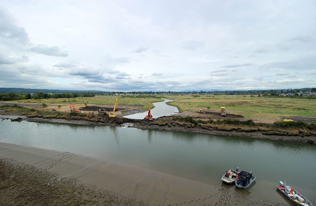
Due to successful efforts to gain the approval of key stakeholders, the project was able to proceed. Before the final stage of levee breach could be attempted, project managers needed to acquire properties in the project area and secure permits and funding from multiple agencies at the tribal, county, state, and federal levels. An initial 200 acres of farmland were purchased by the Tulalip Tribes in 1998, and additional land was acquired over the years. Through a combination of purchasing with restoration funding, easements, and land swaps, the total acreage of the project reached 315. The process was complex and involved years of difficult negotiations, which in the end took nearly 20 years and $20.5 million to complete.
As the land acquisition, permitting, and funding pieces fell into place, the physical work of restoration was able to commence. From 2008 to 2015 workers engaged in preparing the estuary site by removing garbage and structures, restoring the streams and natural range in topography, and planting native vegetation. A setback levee was constructed by the U.S. Army Corps of Engineers in order to protect the City of Marysville's stormwater filtration facility adjacent to the estuary site. At the recommendation of consultants hired for the project, Alan Creek was rerouted so that its outlet was farther upstream; another measure designed to protect the stormwater facility. Aside from this alteration, Alan and Jones creeks were restored as close to their historic states as possible.
Restoration Progress and Outcomes
The work of restoring the Qwuloolt Estuary did not end with the breaching of the levee, which took place on August 28, 2015, though the period of human intervention had largely ended. In the years following, change has come from the repetition of natural processes. Tides bringing in salt water repeatedly flood fields still containing invasive species, slowly killing off plants that are no longer suited for the new environment. Decomposing dead plants return organic matter to the slowly changing soils. Incoming tides also bring sediment that continues to alter the topography and carve channels and streambeds as they recede.
Human interaction with the estuary has not ceased altogether. The focus has shifted from active restoration work to monitoring the site as natural forces continue to effect change. In the years since the breach, several monitoring stations have been installed to analyze sedimentation and hydrology. The Northwest Fisheries Science Center began monitoring pre-breach fish populations in 2009 in collaboration with the Tulalip Tribes. Before the breach, studies showed that 90 percent of fishes observed were invasive species; these populations have dwindled because they were ill-suited for survival in a brackish environment.
Monitoring, particularly of salmon populations, has continued in the years following the breach, receiving funding from the Pacific Coast Salmon Recovery Funds, the Environmental Protection Agency National Estuary Program, and the Tulalip Tribes. Within two months of the breach, marine species such as smelt and coho were observed in the recovering habitat. The variety and abundance of fishes has increased over time, but progress is still dependent on continued habitat maturation. Those observing the salmon populations have noted that the temperatures in the estuary warm sooner than in other established habitats because there is still a lack of appropriate vegetation to provide shade. Fishes observed will use the site, but for shorter periods than at other sites where the temperature was better regulated from extremes. Despite the somewhat challenging conditions, approximately 1,000 fish per hectare are estimated to be in the channels during peak season. Sampled Chinook DNA shows that individuals visit from as far as the Skagit and Stillaguamish rivers; Snohomish River Chinook seem to follow a reverse pattern by visiting estuaries in those locations.
Habitat usage by other wildlife continues to grow, as native vegetation matures and outcompetes the invasive species that remain. At the time of this essay [2021] it was estimated that 30 to 40 percent of the site was vegetated. Much of the land is currently mudflats, though that will change as sediment and organic materials continue to accumulate and restore the topography. Over 350 species of birds have been observed using the estuary for foraging, nesting, roosting, and hunting. Mammals present include harbor seals, sea lions, beavers, otter, mink, muskrat, raccoons, deer, coyotes, porcupines, and various small rodents. Despite the initial fears of the neighboring property owners, the site does not appear to have attracted more rats; the dominant rodent species at the site seems to be voles.
Aside from the benefits to local wildlife, the Qwuloolt Estuary has become a destination for people who enjoy outdoor recreation. The City of Marysville created 1.8 miles of new trail to explore the estuary and connect with the Ebey Waterfront Park on the west side of the estuary. Trails leading from Harborview Park on the east side of the estuary provides a more forested approach to the site and connect a residential neighborhood with the habitat. Both trailheads have become popular with wildlife enthusiasts, birdwatchers, and those who just want a quiet, scenic place to recreate.
The continued success of the Qwuloolt Estuary restoration remains dependent on regional and global factors. The Snohomish River watershed produces 25-50 percent of the coho salmon in the Puget Sound region but currently retains only about 17 percent of its historic estuaries. Other areas of the Snohomish River Estuary have been involved in either active or passive restoration efforts, including Ebey, Spencer, and Smith islands, as well as Union Slough. Global climate change brings new challenges to salmon habitat preservation in the form of rising sea levels and water temperatures. Increased urbanization along the Sound threatens habitat in other locations. In the years to come, the Qwuloolt Estuary will serve as a model for how to engage residents and governments in a way that all stakeholders see the value of the vital work being done.
