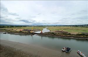
On August 28, 2015, the North Ebey Slough levee at Marysville, Snohomish County, is breached by construction workers, allowing tidal waters to flow freely into the newly named Qwuloolt Estuary for the first time in more than a century. The breach culminates more than 20 years of collaborative outreach, planning, and work led by the Tulalip Tribes to restore vital habitat for native salmon and other wildlife on the Snohomish River.
Reclaiming a Wasteland
The land that would become the Qwuloolt Estuary was removed from Native American stewardship in 1855 with the signing of the Point Elliott Treaty and the creation of the Tulalip Reservation adjacent to Marysville. Over time the land was acquired by non-Native settlers to be used for agriculture, and then deforested and cleared of all larger species of native vegetation. To convert the marshy tidelands to pasture, a levee with tide gates was constructed to prevent brackish water from saturating the soil.
Agricultural activities continued until the early 1960s, when, after a brief period of disuse, the land was converted to a landfill. From 1964 through 1979 the Seattle Disposal Company deposited an estimated 4 million tons of industrial waste in what was referred to as the Tulalip Landfill. The waste was improperly stored, and the site began to leach toxins into the Snohomish River Estuary and continued to do so long after the closure of the landfill. This contamination caused the loss of 147 acres of intertidal wetland habitat.
In 1994, a coalition called the Natural Resource Trustee Council was formed to assess the damaged caused by the landfill and to develop a list of restoration options. A year later the landfull was declared a federal Superfund site, allowing access to additional funding. A site adjacent to the former landfill was then selected for restoration. The Lushootseed word Qwuloolt -- meaning "marsh," "salt marsh," or "great marsh" -- was chosen for the future estuary.
In 1998, the Tulalip Tribes purchased 200 acres of farmland for the project. Eventually, another 115 acres were added through purchases, easements, and land swaps, bringing the total to 315 acres. From 2008 to 2015, workers prepared the estuary site by removing garbage and structures, restoring streams and topography, and planting native vegetation. Total cost for the project was $20.5 million.
The Levee is Breached
Construction crews were at the levee at sunrise on August 28, 2015, ready to move their excavation equipment onto the breach location. As boats cruised by, the workers chipped away at the saltwater side of the structure, finally reaching the water level around noon. Just before 1 p.m., the freshwater side of the levee was breached, and the two water sources were finally able to intermingle. Crews completed the excavation work around 2:30 p.m. as the tidal waters slowly began to flood the newly-reconnected Qwuloolt Estuary.
By 2021, marine species had returned to the recovering habitat; 30 to 40 percent of the site was vegetated; more than 350 species of birds had been observed; and mammals present included harbor seals, sea lions, bevers, otter, mink, muskrat, raccoons, deer, coyotes, and porcupines. In addition, the Qwuloolt Estuary had become a retreat for humans after the City of Marysville built 1.8 miles of new trails through the site for exploration and to connect with the Ebey Waterfront Park on the west side of the estuary.

