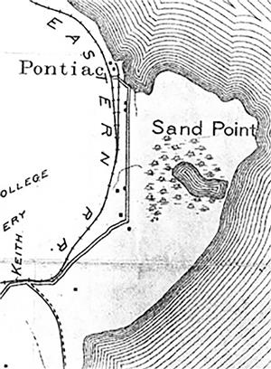
On August 29, 1855, the area around the later-named Sand Point on the western shore of Lake Washington was surveyed, so that settlers could homestead the land and acquire it from the federal government. Indians had preceded the settlers by thousands of years, gathering various plants and animals from the point that juts into the lake. But the six-man survey crew led by William A. Strickler was perhaps the first group of EuroAmericans to walk over and explore Sand Point. After the survey was completed, the land was opened for settlement, but it would be 13 years before the first homesteader would settle on the point.
In 1850, four years after the United States settled the Oregon Boundary Dispute with Great Britain, the United States allowed settlers to homestead land. After the settler cleared a portion of the land and established a farm for a required number of years, he or she would receive title to the land and become the owner. Except for the small group of American and British immigrants who arrived in Oregon and Washington in 1855 and before, settlers had to wait for the land to be surveyed by the U.S. Land Office before they could officially homestead it.
The Way the United States Is Surveyed
In the United States, land is surveyed in the following manner. Land is divided into one-square-mile sections (less if lakes, rivers, or salt water "intrude"), using a grid of north-south and east-west lines one mile apart. The square miles are grouped together in six-mile by six-mile squares, making 36 square miles. Each of these one square mile sections is numbered from 1 to 36 and called a township. Surveyors were hired to establish, locate, and mark each one of these grid lines that crossed land. Settlers used the lines created by the surveys to establish the boundaries of the land they intended to homestead.
The Survey of Sand Point
On August 7, 1855, William A. Strickler was awarded the first contract to survey a township in King County. The township included land between Puget Sound and Lake Duwamish (also called Lake Washington) from about what would become Yesler Way (in Seattle) on the south to just north of Green Lake and Sand Point on the north. During the next two weeks, Strickler hired five members for the survey crew: David Phillips as compassman, W. H. Gilliam and Walter Graham as axemen, and Henry G. Parsons and Asa Fouler (Fowler?) as chain carriers. On August 23, 1855, the Strickler crew started surveying the township, which was designated 25 North Range 4 East.
On the morning of the sixth day, August 29, 1855, after surveying a one-mile section line, the crew arrived at what would later be called 55th Avenue NE and NE 65th Street Then they headed due east towards Lake Washington. After a block or two they entered an alder grove which extended to the north and south. After about four blocks they returned to a forest of Douglas fir trees that ranged in size from two to six feet in diameter. When they reached the future site of the south entrance to Sand Point Park, the surveyors entered a swamp that extended nearly to Lake Washington. The wetlands reached a quarter mile to the north. The surveyors gave the following description to the land: “Land Gently rolling. Soil 1st rate in swamp, 2nd rate on upland. Timber, fir, cedar, Hemlock, Alder, Ash, etc.” The surveyors also noted a small lake within the swamp.
The six man crew retraced their steps and returned to the future location of 55th Avenue NE and NE 65th Street and surveyed a line due north along 55th Street. They surveyed amongst fir trees ranging from two to six feet in diameter and cedar trees at least 40 inches in diameter. Along this one-mile section they crossed two streams both about 20 inches wide, one just north of NE 75th Street and another just north of NE 80th Street. Both streams emptied into a bay later called Pontiac Bay. This section line was described as “Land hilly [and] 2nd rate. Timber, fir, Cedar, Alder, &c." Strickler called it quits for the day.
They completed the survey of the nearly 36-square-mile township by the end of September 1855 and submitted a report to the U.S. Land Office just before the October 1855 so-called Indian War started. This conflict scared away a number of potential settlers and it would be four years before another township would be surveyed in King County. And although the Strickler survey opened the Sand Point area for settlement, it would be 13 years before William Goldmyer (1843-1924), the first homesteader, settled on the point.

