Originally a scattered collection of farmhouses on an arid lip of the Columbia Plateau, the town of Othello boomed after the 1909 arrival of the Chicago, Milwaukee, St. Paul and Pacific Railroad, which designated the town as one end of its Coast Division. Despite the Milwaukee Road’s prolonged financial difficulties, Othello’s railyards stayed busy and provided an economic base for the town and surrounding farms. In 1953, the Columbia Basin Project began supplying irrigation water to the area, and the agricultural industry rapidly diversified and expanded. The establishment of potato processing plants on the edge of town provided another economic boost; Othello produces about 15 percent of the french fries consumed in the United States. Although the Milwaukee Road finally closed its operations in 1980, Othello’s population has been both expanding and changing for seven straight decades, and the town is thriving.
The Coming of the Railroad
As with many Western towns, water and the railroad were powerful forces in the history of Othello.
Situated on the western edge of an arid, gently undulating plateau, the site of Othello overlooks the drainage of Crab Creek as it makes its way westward toward the Columbia River, with Mount Rainier visible on the horizon on cloud-free days. Native Americans of the Wanapum, Palouse, Sinkiuse, and other tribes used trails that passed near the future town, but the scarcity of water discouraged long-term settlements. In 1859, Army captain John W. Frazier oversaw the construction of a road from the White Bluffs of the Columbia River over the "saddle" in the Saddle Mountains and along Crab Creek to the vicinity of Moses Lake, where the road struck northeast toward Fort Colville. (Switchbacks down the north side of the Saddle Mountains are still visible from Highway 26.) However, military convoys, prospectors headed toward the mines of Idaho, and settlers traveling toward northeastern Washington tended to hurry past the dusty perch on which Othello now sits.
Around the turn of the twentieth century, dryland wheat farmers looked at the area’s sagebrush barrens and wondered if they could wring a living from the soil. The panhandle of Adams County, which sticks like a big toe from the county’s southwest corner, gets between 6 and 10 inches of rain a year – just barely enough for dryland wheat in a good year, not nearly enough in a bad one. As local historian Gladys Para (1928–2022) wrote, "Clouds had a tendency to split and bypass the Panhandle, where Othello would later take root and grow" (History of Adams County, 45). Nevertheless, some of the state’s last unclaimed land attracted homesteaders, and by 1903 a group of farmhouses clustered loosely around what is now the intersection of Main Street and Broadway Avenue. That year, as the daughter of an original settler later recounted:
"we and all the neighbors for a radius of ten miles or more realized the need for a postoffice. A petition was circulated by the postoffice department and we were sent blanks for name suggestions. The only stipulation being that we not choose names ending in 'burg' or 'ville' as they were beginning to be much too numerous. My older brother and I submitted names. I recall I submitted 'Viva' after a very dear girl friend. My mother, Nettie B. Chavis, submitted Othello; it being a favorite name with her. She grew up in Tennessee and their postoffice at one time was known as Othello" (Ramsey, 141).
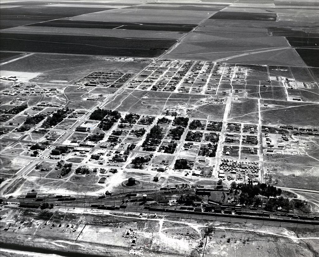
Despite its new name, the existence of a post office was no guarantee that the settlement would survive – old maps of Eastern Washington are dotted with the names of aspiring towns that succumbed to the wind and the dust. But in 1906 surveyors for the Chicago, Milwaukee, and St. Paul Railway Company began planting stakes down a slight hill from the post office, and word spread that a new railroad was on the way. The next year the railroad announced that the site would be the eastern end of its Coast Division, which meant that crews and locomotives arriving from the east and west would change there. As newcomers anticipating the arrival of the railroad moved to the area, a five-block by six-block area from the post office to the future railyards was platted, and the railroad adopted the post office’s name for the new town. The railroad also drilled wells to supply its construction crews, and farmers paid 50 cents to fill horse-drawn wagons with the railroad’s water. The first passenger train from Othello was a local special taking fairgoers to the 1909 Alaska-Yukon-Pacific Exhibition in Seattle.
The coming of the railroad led to boom times in Othello. The next few years saw the construction of hotels, restaurants and cafes, saloons, churches, hardware and grocery stores, lumberyards, a schoolhouse, a bank, a barber shop, newspaper offices, a tobacco store, and a theater. Railroad facilities grew to include section houses, stockyards, ice and coal houses, freight and passenger depots, a roundhouse, a wheel shop, and fueling and sanding stations. Struggling farmers hired on with the railroad to make ends meet. Crews bedded down in hotels, bunkhouses, sleep shacks, and rooming houses. Incorporation came in 1910, when the population was about 400.
The Milwaukee Road, as it came to be known, was the third transcontinental railroad built across Washington; in retrospect, that was probably one too many. By the eve of World War I, four different transcontinental and regional railroads served Adams County, which is only about 48 by 37 miles in extent (not counting the 18- by 12-mile panhandle). Competition among the companies was fierce, and the Milwaukee Road fought hard for both passenger and freight traffic. In 1920, it electrified the Coast Division from Othello to Tacoma. Steam (and later diesel) locomotives arriving from the east were replaced in Othello by electric engines, which drew power from overhead lines for the climbs over the Boylston Mountains to Ellensburg and over the Cascade Mountains to Tacoma. At that point, the Milwaukee Road was the fastest and most efficient railroad in the world.
But the great era of railroad construction was coming to an end. The opening of the Panama Canal in 1915 drastically reduced transcontinental rail freight. Agriculture prices and wages fell in the 1920s, well before the Great Depression afflicted the rest of the economy. Towns in Eastern Washington quit growing and in many cases contracted. Meanwhile, a new means of transportation was beginning to make itself felt. As historian Carlos A. Schwantes wrote in his book Railroad Signatures across the Pacific Northwest, "The surprise winner in the two-decade-long contest between steam and electric carriers was the automobile."
In 1925 the Milwaukee Road declared bankruptcy, and it continued to suffer from financial problems for decades. Nevertheless, the railyards of Othello stayed busy with Milwaukee Road freight and passenger traffic. Schoolboys known as "callboys" kept track of railroad workers’ schedules and banged on their hotel doors to wake them up and make sure they got to work on time. Electricity reached the town in 1931 from a substation on the Milwaukee Road; to celebrate, the townspeople held a bonfire on Main Street. The population of the town underwent a gradual decline – from 649 in 1920, to 558 in 1930, to 420 in 1940, with perhaps another 150 living on nearby farms. Nevertheless, by the beginning of World War II, more than a hundred men were still working round the clock in three shifts in the railyards of the Milwaukee Road.
The Arrival of Irrigation Water
For more than half a century, farmers in the Othello area had lamented, "If only we had water, this soil would grow anything" (Lage, Prologue) In 1953, they got their wish.
Since the end of the nineteenth century, the federal government had been studying the idea of pumping water from the Columbia River to irrigate Eastern Washington’s parched flatlands – but there was a problem. The canyon where the water would need to be withdrawn was so deep that pumping it to the canyon rim was prohibitively expensive.
The construction of Grand Coulee Dam from 1933 to 1941, which raised the water behind the dam 400 feet above the original streambed, solved half the problem. The Columbia Basin Project, which was approved by Congress in 1943, solved the other half. Between 1951 and 1953, six of the largest pumps in the world were built to lift water an additional 280 feet to a feeder canal that led to an ancient coulee formed by prehistoric floods, with six more pumps added between 1971 and 1984. From the storage reservoir, named Banks Lake, water traveled through thousands of miles of canals, tunnels, and siphons to more than 600,000 acres of thirsty farmland.
In May 1953, many of Othello’s residents gathered on the west edge of town to watch the first trickles of water make their way down the newly constructed Potholes Canal. Over the next few years, normally dun-colored farms in the area turned emerald green. Farmers began to grow potatoes, sugar beets, alfalfa, corn, canola, peas, asparagus, carrots, mint, grapes, and many other crops. Apple, pear, peach, and cherry orchards adorned nearby hillsides. Water expanded the size of nearby feedlots and calf-and-cow operations. The Othello Golf and Country Club took shape on a former alfalfa field a few miles out of town. New businesses cropped up to serve farmers’ and townspeople’s needs. Othello once again began to prosper.
The rapid expansion and diversification of farming, along with inexpensive electricity from the dams built along the Columbia and Snake rivers, led to a new industry. In 1961, a frozen food company on the outskirts of town called Othello Packers began to process peas, carrots, and corn. Three years later, a farmer named Peter J. Taggares opened the Chef Ready french fry factory. It was the beginning of a french fry empire. Over the next few decades, more plants were built to process and freeze french fries, hash browns, and tater tots, and farmers turned over more and more of their land to the thick Russet potatoes favored for frozen potato products. By 2023, Othello was producing roughly 1.5 billion pounds of frozen potato processed foods, including about 15 percent of the french fries consumed in America. Agricultural workers, many from Mexico, moved to the area to work on potato farms, in the processing plants, and for associated enterprises.
Many farmers in the area profited during this period of rapid expansion, but none more so than Pete Taggares. The son of a Greek immigrant, he was raised in Prosser and started a small farm near Othello in 1956 to take advantage of the new irrigation water. As his farm prospered, he began to buy those of his neighbors, defying the hopes of the Columbia Basin Project’s architects that water from the Columbia would benefit mainly small-scale farmers. A proud and often profane man, Taggares had a fondness for the simplicity and order of the color white. He painted the telephone poles around his farms white to a height of six feet. His tractors, trucks, Cadillacs, Mercedes, private plane, yacht, and home just east of town were all white. When he died in 1999 at the age of 67, his estate was valued at more than a quarter billion dollars.
The boom in farming and food processing led to rapid population growth. From a population of 526 in 1950, the town grew to 2,669 in 1960, 4,122 in 1970, and 4,454 in 1980. The schools underwent a comparable expansion. Since 1908, a brick, two-story schoolhouse on Fourth Street had been enough to handle the town’s school children. Between 1953 and 1970, the town built two elementary schools, two middle schools, and a new high school to accommodate the burgeoning school-aged population. The original brick schoolhouse was torn down in 1953 to make way for the new high school’s football field.
Othello may have seemed far away from the rest of the world during this period, but it sometimes played a role in events of global importance. From 1944 through 1971, the nearby Hanford Nuclear Reservation, just 15 miles away on the other side of the Saddle Mountains, produced plutonium for the nation’s expanding nuclear arsenal. About once a month, a locomotive based in Othello traveled to Hanford to pick up an armed passenger car, nicknamed the "Bomb Car," that carried plutonium to bomb-making facilities in Colorado. On the crest of the Saddle Mountains south of town, the Othello Air Force Station, built in 1951, monitored the sky for Soviet bombers during the height of the Cold War. Deactivated in 1975, the station was called Radar Hill by residents because of the two large radomes visible from almost anywhere in town.
As Othello’s population continued to grow – from 4,638 in 1990, to 5,847 in 2000, to 7,364 in 2010, to 8,549 in 2020 – its demographics changed. Anglo children who grew up in town tended to move elsewhere after high school and not return. As they began to have children, many of their retired parents also moved to be nearer their children and great-grandchildren. Meanwhile, Hispanic children raised in Othello tended to stay near their families when they came of age, even if they left temporarily to attend college. At the same time, new Hispanic residents arrived from other parts of the United States, from Mexico, and from other Latin American countries. By 2020, the Hispanic population had grown from 30 percent of the town’s residents in 1980 to more than 75 percent, and business in town was as likely to be conducted in Spanish as in English.
Continuity and Change
The rodeos and demolition derbies held at the fairgrounds outside town have drawn large and enthusiastic audiences for decades, but Othello has changed in many other ways since the 1970s.
In 1980, after a long history of financial difficulties, the Milwaukee Road ended its operations west of Miles City, Montana. By then the growth of the agricultural industry in Othello had more than compensated for the declining fortunes of the railroad, and the economic impacts on the town of the Milwaukee Road’s final bankruptcy were minimal. In most of Washington, the route of the Milwaukee Road was converted to what is now the Palouse to Cascades Trail, which extends westward from the border of Idaho to Cedar Falls outside North Bend. But the tracks from Warden, about 12 miles northeast of Othello, to Smyrna, about 32 miles to the west, remain in place and are used by the Columbia Basin Railroad to transport agricultural and industrial products.
A few years before the last Milwaukee Road crew left Othello, a local group bought a derelict hotel built near the tracks in 1912 and converted it into an arts and handcrafts center. Since then, the Old Othello Art Gallery has served as a center for arts and arts education and has welcomed visitors with a 1946 Milwaukee Road caboose that contains displays on the town’s railroad history. Three blocks up Larch Street, the 1908 First Presbyterian Church building serves as the town’s history museum.
In the past, hunters from Western Washington came to Othello to hunt pheasants introduced into the fields and lakes by the Bureau of Reclamation. Now birders come to the annual Sandhill Crane Festival to watch the cranes from a distance and attend lectures.
In 2002, a Walmart superstore opened on the outskirts of town. "That was when corporate America really arrived in Othello," said Shawn Logan, who was elected the town’s mayor in 2012. "The drugstore, the grocery store, those were all family owned" (Logan interview). Within a few years, many of the mom and pop stores that had served Othello for years were gone, and their owners had largely moved away.
As the town became more Hispanic, it also became younger. In 2020, about 40 percent of the population was 17 or younger, compared with the statewide average of 22 percent. New playgrounds, futsal courts, and a splash pool keep kids active. The schools again filled to overflowing as new housing developments rose on the edge of town.
Adams County still needs thousands of agricultural laborers, and their relatively low wages help keep Othello’s average income below the state average. But the town, with its wide and freshly paved streets, expansive parks, and verdant surrounding farms, is thriving.
Ironically, water has become an issue again. Towns and farms in Eastern Washington have always relied on deep wells for water, even after the Columbia Basin Project began supplying farmers with abundant irrigation water. As has happened in many other parts of the country, continued pumping from the underlying aquifer has drawn down water levels to the point that many wells have either run dry or produce only brackish water. It may be possible to purify irrigation water to supplement Othello’s water supply while meeting the expanding needs of farmers. But once again the availability of water has become a critical factor in the town’s future.
