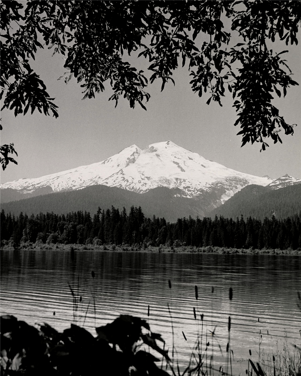
Located in Whatcom County, Mount Baker is the third tallest mountain in Washington. At 10,781 feet, it has long provided beauty, resources, and adventure opportunities to people in the Pacific Northwest. Mount Baker, also known as Kulshan, occupies a special place in the lore and history of the Native American Nooksack people. Since European exploration and settlement in the nineteenth century, it has been a source of valuable natural resources – including gold and timber – and recreation opportunities for white settlers since the mid-nineteenth century. In 1897 and 1898, the Washington Forest Reserve preserved land on and around Mount Baker, which later became Mount Baker National Forest. Ongoing environmental policy decisions threaten the forests around Mount Baker, which nevertheless continues to be a popular destination for skiers, climbers, hikers, and other outdoor enthusiasts.
Geological History
Mount Baker is the youngest volcano in the North Cascades volcanic belt, a range of mountains formed by the subduction of the Juan De Fuca tectonic plate under the West Coast of North America. Volcanoes gain their shape from the expulsion of magma that hardens and adds new layers and features to the mountain. Over 200 lava flows make up the structure of Mount Baker. Geological evidence suggests that glaciers have carried away pieces of the mountain.
Eruptive activity that has formed the shape we know today began around 140,000 years ago. There was much cone growth between 30,000 to 40,000 years ago, and most of the upper cone was formed less than 20,000 years ago. Mount Baker saw its last period of major growth at the end of the last glacial period, about 12,000 years ago. Lava flowed from the mountain, creating fans on both the southwestern and northwestern faces.
During the Holocene period, the most recent geological time period, which includes the last 12,000 years, there have been only two eruptions that have affected the shape of the mountain. The Schriebers Meadow cinder cone, on the south side of Mount Baker, was formed about 9,800 years ago from an eruption just south of the mountain. This eruption resulted in one of the largest lava flows in the Cascades. An eruption from Sherman Crater about 6,700 years ago caused pieces of the mountain to fall off and was responsible for the formation of Baker Lake. After the initial eruption, avalanches caused the flanks of the volcano to collapse. One volcanic mudflow, or lahar, traveled east into the Baker River valley, causing the river to dam and form Baker Lake.
In more recent history, it is common for the volcano to experience debris avalanches and volcanic mudflows. There was a period of hydrothermal activity, including steam-driven blasts, in the mid- to late-1800s that caused small portions of the Sherman Crater to collapse. Sherman Crater is home to many openings that produce sulfur gas, making the crater the most hydrothermally active area on the mountain. On cold and calm days, the sulfur creates a dramatic steam coming off the mountain.
Kulshan and the Native Relationship to the Mountain
Mount Baker has been an important landmark for Pacific Coast Tribes. The Nooksack have different names for areas of the mountain such as Kweq’ Smánit, meaning "white mountain" and Kwelshán, meaning "shooting place." This name refers to the meadows near the peak of Baker where the Nooksack often hunted. The Lummi tribe uses the same Kwelshán to refer to the peaks. However, Lummi translators have said the word means a place that has been shot, rather than a place where shooting occurs. This may be because the Lummi did not hunt on the mountain and interpreted the meaning of the word differently. The Halkolmen language uses the similar Kwelxá:lxw. In Lushootseed, Baker was called Teqwúbe7. This word translated to snow-capped peak. It was also used to refer to Mount Rainier. Kulshan is often referred to as the native name for the mountain, and the Lummi and Nooksack names support this claim.
The Nooksack and other Salish speakers have existed in the Puget Sound region for several thousand years. Coastal tribes hunted and gathered near and on the mountain, but what likely brought them up the hills was the pursuit of mountain goats. While they hunted the animals for their meat, more valuable was the goats' hair that provided warmth.
Mount Baker, or Kulshan, exists as a character in much native folklore. Writer John C. Miles recounted the story in his book Koma Kulshan: The Story of Mt. Baker. For the Nooksack, Kulshan played the character of a young and handsome man who had two wives and several children. One wife stole Kulshan's attention away with her sweet manner. The other wife became jealous and resentful. To try and win back her husband's affection, she threatened to leave him and take her things with her – berries, fruits, sweet bulbs, and flowers. She left and her children lamented the loss of their mother, but she was sure that Kulshan would call her back. As she traveled farther and farther away, she continuously looked back, hoping Kulshan would be summoning her to return. But the farther she got, the higher she had to climb to see her abandoned husband. Eventually, she decided to make camp and set down all of her belongings around her. At this point, she had climbed such hills and reached on such tippy toes trying to see Kulshan that she had grown to enormous heights and become what we now refer to as Mount Rainier.
While Native Americans would guide mountaineers near the summit, it has been recorded that they did not join in reaching the highest peaks. Some recollections say that the Native Americans guides spoke of spirits and were too afraid to travel up the slopes. The difference between a sense of fear and a sense of reverence may have been lost in translation. Perhaps it was fear of spirits, or perhaps it was reverence and respect for the mountain and its spiritual energy that kept the guides away from the summit.
Before non-Native settlement in the area, Native American tribes took responsibility for stewardship of the land. With the Treaty of Point Elliott, signed in 1855, the United States government laid claim to millions of acres of Native American ancestral land, but reserved the Native people's rights to fish, hunt, and gather on "open and unclaimed lands" ("Land-Based Treaty Rights").
European Contact
The Europeans who claim to have discovered Mount Baker gave it their own names. Spanish mariner Gonzalo Lopez de Haro (1761-1823) spotted the peaks in 1790 and named it "La Gran Montana del Carmel." The modern-day name "Baker" honors Third Lieutenant Joseph Baker (1767-1817), who saw the peak from the British ship Discovery, led by Captain George Vancouver (1758-1798) in 1792. The peak was spotted while the ship was in the Strait of Juan de Fuca, during Vancouver's voyage to survey the coastline and secure Britain's territorial hold on the Northwest coast. There are many other Pacific Northwest landmarks named after the crew aboard the Discovery, such as Puget Sound, named for Lieutenant Peter Puget (1765-1822), and Whidbey Island, named for Lieutenant Joseph Whidbey (1757-1833).
First Recorded Ascents
Since the mid-1800s, Mount Baker has been a popular backpacking destination with routes varying in difficulty, the most traversed going along the Coleman and Easton glaciers. In 1866, English settler Edmund Thomas Coleman (1824 1892) made the first recorded attempt to summit the mountain. An experienced mountaineer and member of the London Alpine Club, Coleman wrote of Mount Baker’s exceptionalism. "The height of the mountain is rendered the more apparent from the circumstances of there being no other peaks in the immediate neighborhood to dwarf it, and also from the comparatively low height of the hills intervening between the spectator and its base" (Miles, 18). Coleman, accompanied by Dr. Robert Brown and Charles Benjamin Darwin, used the Skagit River to navigate to the base of the mountain. Natural obstacles slowed their journey, and they chose to return home when Native Americans refused their request for a guide and would not allow them to travel any farther.
But Coleman was determined to reach the summit. Edward Eldridge (1828-1892) of Bellingham told Coleman he would help him by procuring canoes and guidance from the Native Americans and advised him to travel via the Nooksack River. Joined by John Bennett (1818-1901) and John Tennant (1829-1893) on his second attempt, Coleman almost made it to the summit. After successfully climbing what would be later known as Coleman Glacier, Tennant fell ill while his two companions reached the saddle of the glacier and traveled farther up the cone. The two were met with an "overhanging cornice of ice ... a wall of ice" (Miles, 168). The travelers did not want to give up, and so spent a miserable night on the mountain, forced to keep moving all night for fear of freezing. The next morning, they made the attempt again, but once more had to admit defeat in the face of dangerous, icy conditions. Coleman and Bennett were probably only 200 feet below the summit of Mount Baker, near what is now referred to as the Roman Wall. It is encountered when climbing Mount Baker via the Easton Glacier route and must be climbed before reaching the true summit.
Twice defeated, Coleman waited two years to make another attempt to summit the mountain. On August 7, 1866, Coleman and his troop went up the middle fork of the Nooksack River, which would guide them to the south side of the mountain. Battling thick forests, difficult weather, anxiety, and poor food rations, the group pitched appropriately named camps to spend the night in the wilderness. "Camp Fatigue" and "Camp Doubtful" marked their journey along the river and "Camp Hope" was pitched 6,000 feet up at Marmot Ridge. At 4 p.m. on August 17th, 1868, Coleman and his companions finally reached the summit of Mount Baker and celebrated with brandy and singing.
While accounts of this first recorded ascent focus on Coleman and his European and American companions, it would not have been possible without the support of Native Americans. According to the accounts of the journey, much of the work concerning canoes, collecting water, hunting for food, and navigation was left to members of the Nooksack tribe who accompanied Coleman’s group for the majority of the journey.
At the close of the nineteenth century, many firsts were seen on the ridges of Mount Baker. New routes were climbed, photography equipment was painstakingly hauled to its peaks, and in 1891 Sue Nevin (1870-1914) became the first woman on record to climb the mountain. As mountaineering grew in popularity, groups formed to take adventurers up the mountain. The Mazamas, an Oregon-based wilderness exploration club, climbed Mount Baker in 1906. The Mountaineers, from Seattle, made the climb in 1908. These clubs allowed inexperienced climbers to learn from and climb alongside more experienced mountaineers.
Recreational climbers were not the only ones drawn to Mount Baker. Others arrived to exploit the rich natural resources. In August 1897, Jack Post (1860-1941), Russ Lambert (1867-1944), and Luman Van Valkenburg (1862-1922) discovered "a thick quartz outcropping extending across the face of bear mountain" north of Twin Lakes while searching for valuable minerals on the mountain (Miles, 81). They named their discovery the Lone Jack Mine. Word spread fast and there was a rush to the location. Men fled their homes to build new ones overnight in hopes of receiving some of the wealth from the mine. Thirty cabins were built, along with two stores and a post office near the site. Bridges were built over the Nooksack and roads were improved to allow for mining machinery to be transported. A portion of the mine burned down in 1907. The last gold ore was shipped from Lone Jack Mine in 1995. Lone Jack Mine yielded over a million dollars’ worth of gold while it was active. Another mine was discovered on what is now Mount Larrabee, called the Boundary Red Mountain Gold Mine; it yielded around half a million dollars’ worth of gold. While these were the only profitable mines of over 5,000 mining claims made on the mountain, prospectors have been important actors in opening, popularizing, and commercially developing the region since 1898.
One memorable and tragic climb involved 25 students from Western Washington University. In July 1939, an avalanche overtook the group of students and six lives were lost. Today (2025), a memorial built of basalt rocks from the mountain still stands outside of Edens Hall and Old Main on the university campus in Bellingham to honor the victims. Western Washington University has always had a relationship with Mount Baker. University students and the Mount Baker Club of outdoor enthusiasts jointly owned Kulshan Cabin, a glacier outpost where students would log accounts of their adventures up until the 1980s when it became obsolete. Students continue to frequent the mountain for educational purposes, using it as a site to study geology, forestry, biology, and more.
Forest Reserves and Conservation
The thick forests through the Pacific Northwest, especially in the Cascades and Olympic mountains, make it an attractive place for loggers. A profitable and growing lumber industry in Washington took advantage of the seemingly limitless timber resources in the area. Lumber executives and mill owners who did not own timberland often logged public land for private profits. Mill owners either stole timber resources or paid modest stumpage fees to acquire timber from public lands. In 1878 the Timber and Stone Act offered 160 acres of public timberland at $2.50 an acre. This law was meant to prevent the corrupt acquisition of timberland, but mill owners found loopholes in the provision to fraudulently acquire sizeable land holdings. Soon, large timber companies held monopolies over the forests.
The General Revision Act was passed in 1891 to reform the use of forest resources. This act called for stricter policies concerning public land use and gave presidents the power to set aside forest reserves on public land. These forest reserves became what we now know as national forests. The Pacific Forest Reserve was established in 1893, and in 1897 became the Mount Rainier Forest Reserve. This reserve allowed for the creation of Mount Rainier National Park in 1899. In 1897 and 1898, eight million acres in the northern Cascades were claimed as the Washington Forest Reserve. In 1908 this reserve was divided into two, the northern Washington National Forest and the southern Snoqualmie National Forest. In 1924 the northern forest was renamed Mount Baker National Forest. The two were rejoined in 1973 as the Mount Baker-Snoqualmie National Forest.
The discoverer of the Lone Jack mine, Jack Post, was one of the region's first forest rangers. When forest reserves were established, there was no formal system in place to protect the land, just the understanding that they were not to be used for private exploitation. Men who were familiar with the area and well-versed in a range of outdoor skills were given the job of maintaining the land. Early rangers had to take a test proving the ability to perform tasks such as identifying species of trees, cutting down a tree with precision, properly making a batch of biscuits, packing a horse, and complete other relevant skills. In 1907, the first Forest Service headquarters in the Mount Baker region was built on Gallop Creek.
In the 1930s, conservation efforts took place near Mount Baker. The Civilian Conservation Corps was established in 1933 as part of a Great Depression recovery effort. The Civilian Conservation Corps goals were to achieve conservation work throughout the country while teaching young men useful skills and helping them find meaningful employment. After developing their skills, these young men would go on to work on projects such as timber improvement, soil conservation, and fire prevention. Civilian Conservation Corps efforts were responsible for the development of important infrastructure that supported the economy, safety, and daily lives of those in the region.
Today, 834,000 acres of the Mount Baker National Forest are defined as Wilderness. The Wilderness Act of 1964 protected certain areas of land from being touched by any human development, and fines may be charged for the use of motor vehicles in designated areas. The goal of the act is to preserve the natural, wild state of the land.
Growth and Tourism
In the early 1900s Mount Baker became a popular tourist destination. In 1911, the Mount Baker Club, a group formed by local leaders to promote development in the Mount Baker region, came up with the idea of the Mount Baker Marathon to draw in tourists and support the local economy. The race would begin in downtown Bellingham and either a train or a car would take competitors to the base of the mountain, where they would race to the summit either on the 14-mile Glacier Trail route or the 16-mile Middle Fork route. The winner of the first Mount Baker Marathon was Joe Galbraith on August 11, 1911. Out of 14 contestants, only six of whom made it to the top, he made the fastest time, taking 12 hours and 28 minutes to go from the city to the peak and back. The second winner was Harvey Haggard, who took 9 hours and 51 minutes. The third race had a disputed win by Paul Westerland and then jointly, John Magnuson after a rematch took place. The annual race occurred three times before being deemed too dangerous. Although the original Mount Baker Marathon was discontinued, other marathons inspired by the mountain still occur. In 1973 a new race called Ski to Sea began. Skiers, runners, bikers, and paddlers compete in teams of three to eight athletes in a relay that takes them from Mount Baker ski area to Bellingham Bay. "Ski to Sea" is currently the largest one-day event held in Whatcom County.
Visits to Mount Baker grew as the area developed. In 1924, 27,498 people came to Mount Baker National Forest. In 1939, that number shot up to 132,000 visitors, 48,500 of whom came in the winter. The beauty of the snowy landscape even attracted a Hollywood film company, which in 1934 began filming Jack London's Call of the Wild at Heather Meadows. However, during World War II, the mountain saw far fewer visitors and the cabins that used to hold skiers sat empty. As the war ended, climbers returned to the mountain with fresh motivation.
Amongst recreational activities on the mountain, skiing and snowboarding are the most popular. The first recorded attempts at ascending the mountain on skis occurred in the winter of 1930-1931. The Mount Baker Ski Club acquired a cabin and began taking regular skiing trips near Heather Meadows in 1931. In 1935, 130 skiers gathered on Mount Baker, competing in the Pacific Northwest Ski Associations first Slalom meet, cheered on by several thousand spectators. In 1937, the Mount Baker Ski Club finished constructing a new cabin just below Heather Meadows and the road was left open during the winter. The growth of the sport inspired logger Arthur Brandlund to build the mountain's first lift. This "hoisted sled" could carry 20 people up about 1,000 feet in less than five minutes. Today, the Mount Baker Ski Area, a business descendant of the Mount Baker Development Company that built and maintained hotels and lodges on the mountain, has eight chair lifts, three lodges, and offers 1,000 acres of slopes to visitors. In the winter of 1998 and 1999, the mountain received a record-setting 95 feet of snowfall due to La Nina weather patterns that season.
Looking Ahead
Stewardship of Mount Baker remains an important part of the mountain's story. In February 2023, the Nooksack Tribe signed an agreement with the U.S. Forest Service to co-manage sections of land within the Mount Baker-Snoqualmie National Forest. Then, in 2024 and 2025, federal forest policy and budget decisions opened the Mount Baker-Snoqualmie National Forest to logging and threatened to strip environmental protections.
