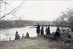
On October 14, 1913, the straightening of the Duwamish River into the Duwamish Waterway begins. Twenty million cubic yards of mud and sand are moved until the bends of the river are filled and the main channel is deepened.
When the Duwamish tribe lived along the river, it meandered in curves to Elliott Bay. At high water and plus tides, much of the surrounding land was under water. Steamboats could navigate as far as Kent, but ocean-going vessels could not use the river.
The Builders
In 1895, former governor Eugene Semple (1840-1908) proposed an ambitious plan of public works which included digging a canal from Elliott Bay to Lake Washington, filling in the tide flats south of downtown Seattle, and straightening the Duwamish River. That same year, the Washington State Legislature authorized the formation of diking and dredging districts.
In 1901, Semple began his canal, and the soil from Beacon Hill was sluiced into the tideflats. Work stopped on the project due to cave-ins, but filling the wetlands continued with soil from regrades in Seattle.
In 1909, at the urging of City Engineer R. H. Thomson (1856-1946), Seattle formed the Duwamish Waterway Commission to sell bonds and to rechannel the river. A deeper, straighter river would allow ships to navigate to the industries envisioned for the reclaimed land, and would also alleviate the flooding that plagued the area.
The Commission purchased a dredge and named it Duwamish I. Dredging began at the County Poor Farm in Georgetown. The meanders eventually disappeared except for recesses in the channel to accommodate high water flows and turning ships. Parts of Georgetown and South Park once on a quiet riverbank found themselves inland. Industry expanded south from Seattle on the newly reclaimed land. By 1920, the Duwamish Waterway had been extended to a depth of 50 feet for 4½ miles.
The old course of the Duwamish can be (in 2001) traced in curved streets of Georgetown such as S Front Street, S Fidalgo Street, and S River Street.

