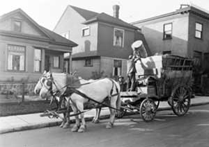
By May 1920, a Seattle garbage dump on Queen Anne hill (Crockett Street between Nob Hill and 3rd Avenue N) has been converted to a sanitary fill, possibly the first in the nation. A sanitary fill is a garbage dump which, while in operation, is covered daily with 10 to 12 inches of earth. After years of use for waste disposal, these sanitary fills can be reclaimed for buildings, parks, parking lots, and other uses.
During the early twentieth century in Seattle, an urgent situation arose concerning waste disposal. The refuse crisis stemmed from the population explosion. In 1900, the Seattle population stood at about 80,000; by 1910, it had leaped to 240,000 people.
A lively controversy bubbled over the relative merits of incinerators (refuse destructors) versus sanitary land fills for the disposal of garbage.
In 1905, City Engineer R. H. Thomson toured Europe to investigate garbage disposal systems and returned highly impressed with the method of incineration (refuse destructors). The idea of the destructors was to use the clinker for roadbuilding and to use the fire to produce steam (for use in steam laundries or to heat buildings). Seattle built four refuse destructors (the first in 1908 on the south end of Lake Union), but they were only used for a few years. Garbage dumps, which were eventually made into sanitary land fills, were persistently found to be more economical.
In May 1920, the following sites were listed as dumping places. They include the Crockett Street sanitary land fill.
- Terry Avenue, south shore of Lake Union -- private property and street;
- South end of Wallingford Avenue -- city property;
- Market Street and 28th Avenue NW -- private property and street;
- North of E Madison, vicinity of 30th Avenue N -- park property;
- 26th Avenue N and E Miller Street -- park property;
- West Garfield and 22nd Avenue W;
- Foot of 26th Avenue NE;
- Puget Mill Property -- one-half mile south the Youngstown;
- 1st Avenue S and W Dakota Street -- Railroad property;
- Oregon Street between 42nd and 44th avenues S;
- Crockett Street between Nob Hill and 3rd Avenue N (the sanitary land fill);
- Block bounded by Dexter Avenue, Valley Street, 8th Avenue and Aloha Street; in Block 9, Eden Addition;
- Southeast corner of 4th Avenue S and Spokane Street -- Park property;
- The Columbia City Branch Library grounds;
- Green Lake field house and playfield area.
By the 1970s, much of this land, some 150 acres, had been reclaimed.

