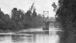
In 1903, the Riverton Draw Bridge (also called the Riverton Drawspan and designated King County Bridge 622-A) is built and placed into service. The wooden plank, swing-span bridge, which crosses the Duwamish, is built to carry foot traffic and horse-drawn vehicles, but is quickly forced to accommodate automobiles as well. The west foot of the bridge is in the community known as Riverton, and the east foot is in the small settlement called Allentown. The road approaching the bridge on the west side of the river crosses the Puget Sound Electric Railway (Interurban) track at grade (at the level of the rails). Drivers entering the bridge from the west must make a sharply angled blind turn from road to bridge, which renders the bridge and its west approaches extremely hazardous.
The Old Military Road
The northbound road, which approached the Riverton Draw Bridge on the west side of the Duwamish, was the old Military road. The Military Road was the original road linking Tacoma and Seattle (and points beyond in both directions). It had been hacked through the wilderness by Captain W. W. DeLacy in 1857. This portion of the Military Road was later designated part of the Pacific Highway. The road here ran on a low trestle between the Interurban tracks and the river. On the east side of the Duwamish, the Riverton Draw Bridge abutted what is now (2003) S. 124th Street, with 42nd Avenue S. running alongside the river, in present-day Tukwila.
Federal funds for the bridge were appropriated in 1899. It was built of Douglas fir and cedar. The Riverton Draw Bridge was a swinging truss drawbridge. The swing span was opened by turning it on a central pivot. During the time the bridge was in place, a sandbar formed around the pier built to carry this central pivot about one-third of the way across the Duwamish from the west bank. This small sandbar or island, heavily covered with brush, is the only remnant of the bridge’s presence.
Prior to the construction of the Riverton Draw Bridge, the only crossing on the upper Duwamish was at Black River Junction. In the three years following the construction of the Riverton Draw Bridge, “three more similar drawspans were built over the Duwamish at Renton Junction, Oxbow and Georgetown” (Reinartz, p. 98).
The Riverton Draw Bridge was inspected about every two years. King County bridge repair teams regularly carried out the inspectors’ recommended repairs to both bridge and trestle approaches. The nature of the bridge material, however, and especially the precarious topography (a steep grade, the Interurban tracks, the trestle road abutting the river) led to periodic landslides onto the Interurban tracks. These slides were sometimes shoveled off the tracks and under the trestle approaches, increasing maintenance difficulties and accelerating wood rot.
Hazardous and At Times Fatal Crossings
By the time the bridge had been in use a decade, the planks were wearing thin and periodic bolt tightening, replanking, and extra nails were becoming inadequate to the task of keeping the bridge in safe shape.
A number of fatal accidents occurred at or close to the bridge, including collisions between cars and the Interurban at the perilous spot where the road crossed the tracks at grade. On March 30, 1915, four people were killed when their car failed to negotiate the sharp turn from the northbound trestle onto the bridge. Their car plunged through the railing, turned over, and landed in about 10 feet of water. Those killed (Thomas and Virginia Prosch, Margaret Denny and Harriet Beecher) were prominent Seattleites and the newspaper coverage of their deaths brought wide attention to the shortcomings of the Riverton Draw Bridge.
Washed Out, Worn Thin, Rotting
Four years after this accident, King County bridge inspector C. Ward Crocket reported, “This bridge is in serious condition. Posts, sills and caps in east approach are rotten, piles, caps and corbel blocks in piers are rotten. Northwest approach on bent washed out, south approach has settled in several places and planking on entire bridge has worn thin. Recommendation: repair this bridge or close it” (May 7, 1919 memo, King County Archives RG 103, Series 36, Box 10).
The Riverton Draw Bridge was condemned for vehicle traffic and closed in 1919 (Bridge Inspection Report, November 23, 1923, King County Archives RG 103, Series 36, Box 10). The east approaches of the span were removed at that time. The west approaches remained in use as a roadway between Riverton and the Quarry district to the north and continued to deteriorate rapidly.
On January 7, 1924, the Board of Commissioners of King County approved Resolution Number 1351 which officially closed the bridge and approaches to vehicles of all kinds (Resolution Number 1351, King County Archives RG 103, Series 36, Box 10).
On March 31, 1927, Bridge and Wharf Inspector J. P. Blum reported, “The entire bridge and approached have recently been razed by Fred Anderson, the South District Bridge Foreman” (Note appended to memo of November 23, 1923, King County Archives RG 103, Series 36, Box 10).

