On November 15, 1805, Lewis and Clark and the Corps of Volunteers for Northwestern Discovery reach the Pacific Ocean at the mouth of the Columbia River, one year, six months, and one day after leaving St. Louis, Missouri, in search of the legendary "Northwest Passage" to the sea.
Visionaries had long believed that the North American continent could be crossed on a ladder of rivers stretching from the Atlantic to the Pacific. Captains Meriwether Lewis (1774-1809) and William Clark (1770-1838) hoped to find a short, easy portage that would connect the Missouri River, which drains the eastern half of the continent, with the Columbia, flowing west to the Pacific. They carried maps indicating that the two river systems were separated by a "ridge of hills" at the Continental Divide, no more than 20 miles wide and passable in half a day. Instead, they found a daunting range of mountains that took weeks to cross.
By the time they arrived at the ocean, Lewis and Clark knew that the Northwest Passage did not exist. Even if it had been possible to carry a canoe from the headwaters of the Missouri (in present-day Montana) and slide it into the nearest tributary of the Columbia, western rivers were not the slow, smooth waterways of the East. On the upper Missouri and on the Columbia, the explorers faced rapids and cataracts that were bigger, swifter, and more dangerous than anything they had ever experienced.
If they had failed in their primary mission, Lewis and Clark had still achieved many of the objectives laid out for them by President Thomas Jefferson when he planned the expedition in 1803. They had found the sources of the Missouri and the major tributaries of the Columbia, followed the Columbia to the sea, collected detailed information about the plants, animals, geography, and inhabitants of the region, and laid the groundwork for American expansion to the coast.
Station Camp
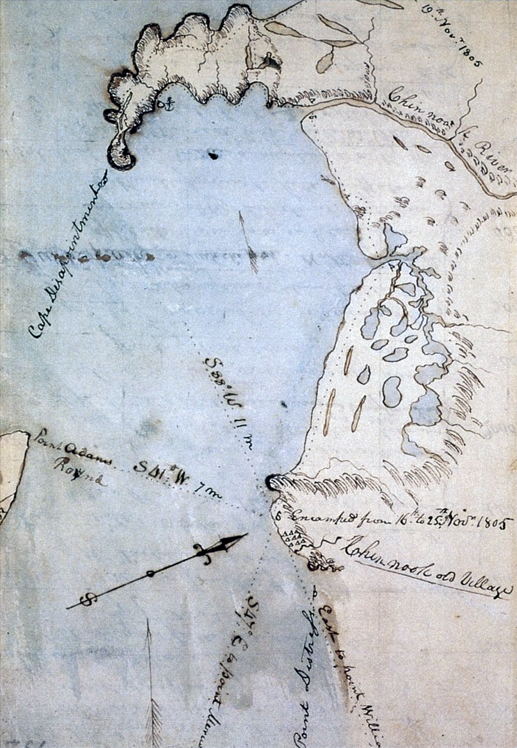
Landing at the highest spot they could find on the northern (Washington) side of the Columbia River estuary, they established what they called "Station Camp." The site is commemorated by Lewis and Clark Campsite State Park, a tiny roadside attraction two miles southeast of what is now the town of Chinook, on U.S. Route 101. The location of the actual campsite is a matter of conjecture, since the shoreline has shifted by several hundred feet since Lewis and Clark passed through.
The camp was situated near what the captains thought was an abandoned Indian village, inhabited only by "flees" (as Clark put it). In fact, it was a summer fishing village, temporarily vacated while the occupants moved to winter quarters. The explorers did not understand the biseasonal settlement pattern of the local Native Americans.
This was not the first time this particular village had been observed by white men visiting the area. Thirteen years earlier, in May 1792, Captain Robert Gray had drawn a map of the mouth of the Columbia that included the village. Lieutenant William Broughton of the George Vancouver expedition also noted the village when he explored the Columbia in October 1792. Lewis and Clark counted 36 houses there in 1805, about the same number that James G. Swan saw when he drew sketches of "Chenook" village in 1811.
The Corps spent 10 days at Station Camp -- their longest encampment in what is now Washington state -- exploring, hunting, and visiting with the Chinook and Clatsop Indians who came to inspect and trade with the newcomers. First Lewis and then Clark led reconnaissance missions to Cape Disappointment (visited and named by John Meares (1756?-1809), a British trader, in 1788). Lewis carved his name in a tree at the northernmost extremity of the cape. Clark and several of the other men added their names to the same tree later, along with the notation that they had come "by land from the U. States."
At the cape, one of the men killed a "remarkably large buzzard" that had been feeding on the remains of a whale. This was a California condor, a carrion bird with a wingspan of more than nine feet (compared to five feet for the bald eagle). Condors, now an endangered species, were common on the shores of the Columbia until the mid-nineteenth century.
A Visit from the Chinooks
Both Lewis and Clark were in camp on November 20, when two of the most important chiefs of the Chinook came to visit: Shelathwell (Chil-lar-la-wil in Clark’s spelling) and Comcomly. One of the members of their large retinue was wearing a robe made from sea otter pelts, which Clark described as "more butifull than any fur I had ever Seen." The captains wanted to buy the robe as evidence of the wealth to be tapped if a trading post were to be established at the mouth of the Columbia. The owner refused everything they offered in trade. Finally, the captains pointed to a belt of blue beads worn by Sacagawea, "the Squar-wife of our Interpreter Shabono" (Clark, Nov. 20, 1805). The Chinook accepted. Sacagawea’s feelings about the matter were not recorded.
The Chinook had been trading with whites since the 1790s. They had learned to drive hard bargains. Clark complained that "they are never satisfied for what they recive in return if ten times the value of the articles they gave" (Nov. 17, 1805). The interchange proved to be deadly for the Chinook. Lewis and Clark counted many cases of gonorrhea and syphilis among the Indians at the mouth of the Columbia, and they saw evidence of earlier epidemics of smallpox. Within 25 years, 75 percent of the Chinook in this area would be dead of European-introduced diseases.
The Vote
On November 24, 1805, the captains put the crucial decision of where to spend the winter to a vote. Every member of the expedition participated in what would be the first election held west of the Mississippi (excepting only Sacagawea’s nine-month-old son, Jean Baptiste). Clark’s slave, York, and Sacagawea both voted -- 60 years before the end of slavery and more than a century before either women or Indians would be granted full citizenship.
The options were to stay put, return to more protected quarters inland, or move to the southern shore of the Columbia. The majority decided to cross over to what is now Oregon. They built a fort near present-day Astoria, named it Fort Clatsop after the local Indians, and moved in on Christmas Day, 1805.
Before they left Station Camp, on November 25, Lewis used a branding iron to burn his name into a tree: "U.S. Capt. M. Lewis." That iron was discovered in the 1890s on one of the islands above the Long Narrows on the Columbia; it is now one of the treasures at the Oregon Historical Society Museum in Portland.
