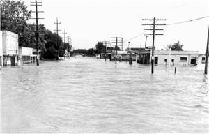
On May 31, 1948, the Columbia River inundates Kennewick and Richland in the worst flood in the history of those two cities. The heaviest damage is in Kennewick where much of the business district lies close to the shore of the Columbia. Richland suffers less damage because the city is not as flat near the shore. After about two weeks, the floodwaters will recede, leaving behind $50 million in damage. There was one death.
The Winter Snow of 1948
There was unusually heavy snowfall over the winter, and rivers in seven states and in British Columbia dumped their spring run-off into the Columbia River. Grand Coulee Dam and the much smaller Rock Island Dam were the only obstacles between the floodwaters and the low-lying land in Benton County. The water flowed virtually unchecked.
In Kennewick, several feet of water covered an area about two miles long and a half-mile wide, paralleling Avenue C. The most damage in Richland occurred at the Hanford Works Transportation Labor Yard, located near today's Shilo Inn. Though workers were able to remove equipment and furnishings before the water came, the buildings and yards were flooded. The Richland "Wye" area, a sparsely inhabited area along Highway 410 between Richland and Kennewick, was completely submerged.
Several Kennewick businesses relocated into a single large structure while their buildings were repaired and cleaned up. Each business contributed to the erection of a frame and paper building at the corner of Benton and Front streets. A local carpenters' union partitioned the building into individual stalls. Ballaines Inc. participated in the venture as the flood waters reached the second floor of its building. Hamberg Furniture and Appliance Co., Jim's Sports Shop, Bunch-Finnigan, Bill's Barber Shop, Don McNeil's Café, and Kennewick Department Store were all partially submerged by water.
The one death was a 19-year-old man named Vernal Nield. He was cleaning out his family's flooded-out restaurant, and was electrocuted when a live wire fell into the water in which he was standing.
The Miracle Mile
In Richland, men worked around the clock to build a mile-long dike, 12 feet tall by 10 feet wide, around downtown Richland. The dike, made of gravel, sand, and riprap, became known as the Miracle Mile since it was built so fast and in such a spirit of cooperation among diverse government and business groups. The dike kept residential areas and the hospital district high and dry and saved the sewer system from contamination.
Water over Highway 410 barred residents from easy access between Richland and Kennewick. To pass from one town to another it was necessary to drive a circuitous route through Benton City, a one-way trip of about 22 miles in contrast to the usual two-mile trip. Even that route was blocked for several days when the Yakima River overflowed its banks and covered Van Giesen Street, the main road to Benton City.
The Atomic Energy Commission, which had taken charge of the Hanford Works in 1947, took immediate steps to rebuild Highway 410. The Commission built a new bridge and raised the original roadbed three feet above the level of the flood. A month later, the four-lane blacktop highway finally reopened.
By mid-June the river returned to its banks, but for the Kennewick businesses along Avenue C, there was much work to do before they could reopen. Buildings had to be cleaned and restocked. Sewer lines, telephone lines, and electrical hookups needed repair. Pest control kept busy spraying for insects that infested all the standing water. National Guard troops from Prosser, Yakima, and Walla Walla assisted with disaster relief, traffic control, and flood abatement. By mid-July most businesses had reopened their buildings along Avenue C.
Overall, the flood caused $50 million worth of damage. Most of the businesses that had been located in the Richland Wye moved to other locations to avoid being destroyed by future floods. The Miracle Mile blocked any future flood from reaching downtown Richland. A new dike along the river in downtown Kennewick protected that area from floods.
In 2004, the cities are considering removing several feet from the top of these dikes to allow for riverside beautification projects. The completion of five hydroelectric dams on the Columbia River between 1950 and 1970 make flooding in the proportions of 1948 highly unlikely.

