On August 28, 1963, the Evergreen Point Floating Bridge opens after years of planning and bickering. The floating portion of the bridge is 7,578 feet (approximately 1.4 miles) long, and crosses Lake Washington in King County from Seattle's Montlake neighborhood to Evergreen Point in the Eastside community of Medina. The bridge will ably serve for more than 50 years.
Lots of Studies, Lots of Talk
Lake Washington's first floating bridge opened in July 1940, but by the end of the decade it was becoming apparent that another bridge might be needed to handle the soaring volume of traffic traveling between Seattle and its suburbs east of the lake, known informally as the Eastside. In 1949 the state ordered a traffic survey to determine the need for a second bridge. The next year Director of Highways William Bugge (1900-1992) announced the state had concluded that one wasn't needed immediately and might not be for as long as 10 years. State officials added that the bridge could be built for approximately $9.5 million.
This didn't stop the growing clamor for a new bridge. The Eastside's population was mushrooming, and by the early 1950s the existing bridge, which crossed the southern part of the lake from Seattle's Mount Baker neighborhood to the Eastside south of Bellevue via the north end of Mercer Island, was handling what many believed was its daily capacity of 20,000 cars. (This number would more than double by the early 1960s.) Things began to pick up in 1953 when the legislature approved construction of a second bridge, and in July of that year Bugge reported that six locations were being considered. Though multiple locations would be proposed and rejected over the course of the 1950s, the main contenders were quickly narrowed down to three: Montlake to Evergreen Point, a more northern route between Sand Point and Kirkland, or a second bridge next to the existing Lake Washington Floating Bridge.
More talk and more studies followed, and estimated construction costs steadily escalated. By 1956 they had soared to $22.1 million. Sometimes it seemed like construction was just around the corner, sometimes it seemed (and as it turned out, was) years away. In 1954 the highway department's Toll Bridge Authority seemed to settle matters when it announced that it had chosen the Montlake-Evergreen Point route and work on the new bridge would begin in the spring of 1955.
More Talking Heads
Instead, still more talk and studies followed. Seattle Mayor Allan Pomeroy (ca. 1907-1966), and later Mayor Gordon Clinton (1920-2011), favored the Sand Point-Kirkland route. The problem was the U.S. Navy had a base at Sand Point and was opposed to a bridge there. Then the state concluded that a Sand Point-Kirkland bridge would cost twice as much to build as a Montlake-Evergreen Point bridge. These developments still didn't quell the arguments to build a bridge from Sand Point to Kirkland. The proposal for a second span on the Mount Baker-Mercer Island route was also a favorite of many, especially Clinton, who seemed to favor anything so long as it wasn't Montlake-Evergreen Point. State highway officials continued advocating for the Montlake-Evergreen Point route, and it was also favored by Governor Albert Rosellini (1910-2011).
The bickering continued through the decade, but did not change the state's initial decision in favor of Montlake to Evergreen Point, and by 1959 there was real progress. Guy F. Atkinson Construction, a well-known international construction company, won the bid early that year to build the bridge's floating structure, while other companies contracted for the remaining work. The state paid for the job with $30 million in bonds (after winning a court challenge over their legality), which were to be repaid with revenue from tolls on the bridge (35 cents, later reduced to a dime for carpools; thrifty commuters could buy 20-ticket books for $3.90, or 19.5 cents per ticket).
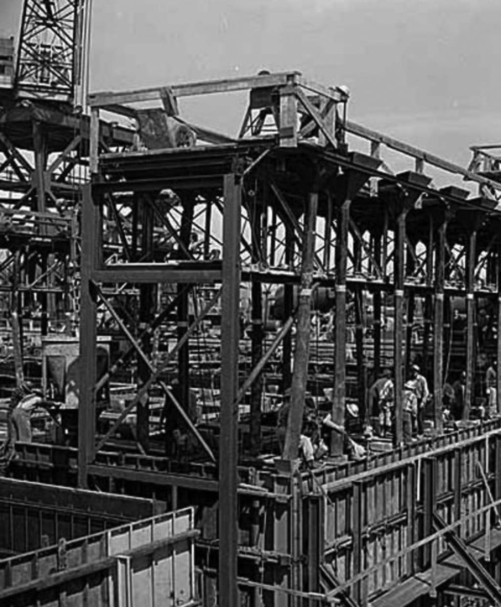
Finally, construction. Ground was broken in 1960, though little on-site construction took place until early 1961, as it was delayed by one final lawsuit over the validity of the construction contract. Once work was under way it seems to have gone relatively smoothly, but not entirely so -- builders missed the planned completion date of June 1, 1963, by several months. The Evergreen Point Floating Bridge was finished by late summer and an opening date was set: Wednesday, August 28, 1963.
Silencing the Sideline-Screechers
It was a glorious late-summer day. Several thousand people came together at the middle of the bridge for the dedication; others watched from boats nearby. Festivities kicked off shortly after 2 p.m. with a water-skiing show, followed by a single-file, slow parade of boats through the bridge's open draw span. Evidently planners underestimated the number of boats that would go through, or maybe the boats were just really slow, but they were still parading through the draw-span opening when dedication ceremonies began about 3 p.m. Dignitaries coming from the Eastside, having already been surprised once that afternoon by a couple of fuel-starved cars in their group and forced to frantically call for a fuel truck at the last second, found themselves stuck behind the open span, watching the ceremonies on the other side and wondering if they'd make it.
They did, and fidgeted with the rest of the crowd as various speakers droned on beyond the scheduled 3:30 ribbon cutting. The sun was very bright, and though temperatures were relatively mild, in the high 70s, it felt warmer on the concrete bridge. The crowd grew more restless. Some began to sweat. Those who could took off their jackets. Those who couldn't wished they could. People squirmed and squinted through speaker after speaker, snapping to when Rosellini spoke and blasted the bridge opponents in his speech, declaring:
"Most of you who are present will never forget the indifference, or the deliberate obstructionist delays, that were encountered … In the history of our state, every major move to answer the challenge of progress has been slowed by stand-patters and nit-pickers and seekers after selfish gain … But today, despite the sideline-screeching and delaying tactics, those goals are fulfilled or nearing fulfillment" ("The Bridge!").
Rosellini had actually toned down his speech from his original version, distributed to the press before the ceremony, in which he made a thinly veiled swipe at Clinton and Seattle when he chided "local interests" for delaying rapid-transit programs. But Clinton maintained a PR smile at the ceremony, responding only with a casual verbal shrug: "Seattle stands to gain or not to gain, depending on the foresight of the planning" ("The Bridge!"). Rumors that the Seattle City Council would boycott the dedication fell flat when two councilmen, Charles Carroll and Mike Mitchell, arrived.
Finally, at 4:05 -- 35 minutes late -- Rosellini cut the red, white, and blue ribbon with an oversized pair of gold-colored wooden scissors as Clinton graciously stretched it taut. (When Rosellini cut the ribbon, it also signaled the opening of the Seattle Freeway, later part of Interstate 5, from Mercer Street to NE 75th Street, and the Roanoke Expressway linking the new bridge to the Seattle Freeway.) The crowd beamed and cheered. Some, including Rosellini, headed off to a parade in Kirkland afterward, and on the way the governor stopped at the toll booths located just east of the bridge and symbolically presented a commuter ticket bearing the number one.
A 50-Year Bridge
As was the case with the first floating bridge, planners underestimated the amount of traffic that would use the new span. This was a good thing when it came to tolls, which were originally expected to remain in place until the year 2000 to pay off the construction bonds. Instead the bridge was paid off by the end of the 1970s. Tolls ended in June 1979 and the booths were dismantled but, to the chagrin of many, tolls returned in December 2011. They were taken with an electronic scanner on the bridge, making a return of toll booths unnecessary.
The Evergreen Point Floating Bridge was 7,578 feet long, slightly more than 1.4 miles; it had 33 pontoons and 58 anchors. Its final cost was more than $24.7 million (nearly $192 million in 2015 dollars). The bridge had two lanes traveling east and two traveling west, and originally had only a small curb just a few inches high separating east- and west-bound vehicles. Jersey barriers were added in the 1970s to better separate the lanes. The bridge was built to stand sustained winds of up to 57 m.p.h. (later retrofitted to 77 m.p.h.), though it was closed when there were sustained wind gusts of 50 m.p.h. or more for 15 minutes. Its draw span could be opened to allow large vessels entering Lake Washington via the Ship Canal to reach the southern part of the lake beyond the bridge.
For years the bridge had several phones placed at regular intervals for marooned motorists to use in an emergency. These phones connected directly to the administration building in Medina, but motorists soon learned that there wasn't always someone there. The bridge was originally expected to handle 15,000 vehicles a day, but in 2015 it handled 70,000, and that was down from the average of 100,000 vehicles that crossed the bridge daily before tolls resumed in 2011.
In 1988, the Evergreen Point Floating Bridge was renamed the Governor Albert D. Rosellini Bridge, but the new name never caught on. The bridge was more commonly known as the "520 bridge," for State Route 520, the highway that it carried across the lake. It was built to last 50 years and it did, but by the 2010s it was showing its age and was too small to adequately handle the huge increase in traffic, which had not been anticipated a half century earlier. The tolls implemented in 2011 were to pay for a new bridge to be built immediately north of the existing 520 bridge, and construction began in 2012. As of summer 2015 the new bridge was scheduled to open in spring 2016, with the original bridge to be demolished the following autumn.
