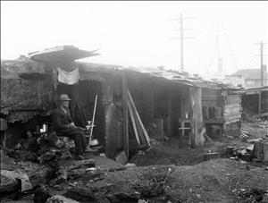
During March 1934, a census of Seattle's Hooverville, a shantytown formed at the beginning of the Great Depression, finds 632 men and seven women living in 479 shanties located south of Seattles Pioneer Square. The residents living in the 12-to-15-square-block area range in age from 15 to 73. Ethnic breakdown of the occupants are: 292 Caucasians foreign born, 186 Caucasians born in the United States, 120 Filipinos, 29 Negroes (African-Americans), three Costa Ricans, two Mexicans, two Native Americans, two Eskimos, and one Chilean.
Occupations varied widely but most were blue-collar workers. They included loggers, civil engineers, butchers, house-to-house salesmen, miners, blacksmiths, storekeepers, barrel-head makers, electricians, dope peddlers, streetcar conductors, tinsmiths, school teachers, an Indian missionary, and others.
Where It Was
The boundaries of Hooverville were: north boundary between South Charles Street and South Dearborn Street; south boundary between South Norman Street and South Connecticut Street (renamed Royal Brougham Way); east boundary Railroad Avenue South (renamed South Alaskan Way), west boundary, Elliott Bay. It was the former location of Skinner and Eddy Shipyard Plant 2 that closed in 1920.

