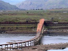
On December 18, 1953, The Dalles Bridge is completed. It carries U.S. 197 across the Columbia River and connects Murdock and Dallesport in Klickitat County, Washington, to The Dalles, Oregon. It is a steel truss cantilever structure, one of two cantilever bridges built in Washington during the 1950s.
The bridge was built less than a mile downstream from The Dalles Dam (completed 1957). The water that backed up behind the dam, now called Celilo Lake, inundated Celilo Falls. These were were terrific rapids, a part of the Great River that served as a key fishing and gathering place for tribal peoples, who considered the site sacred.
The Dalles Bridge is a steel cantilever structure composed of 33 sub-spans. Three of the sub-spans comprise a riveted steel Warren through truss. (A through truss is braced both above and below traffic. A Warren truss has diagonal members that form the letter W.) The bridge is 3,339 feet long.
The first ferry service to cross the river at this spot was in operation by 1854. From 1865 various enterprising persons tried to gain support for a bridge. Both Oregon and Washington highway departments approved the idea in 1947. But the dream was not realized until Congress gave approval to the U.S. Army Corps of Engineers in 1951 to begin planning The Dalles Dam. The bridge was built in connection with the dam. Wasco County, Oregon, officials financed it by issuing bonds, to be repaid by tolls.
Construction began but complications resulted when the Corps of Engineers completed studies showing that the dam's spillway requirements meant the bridge would have to be sited farther downstream. The bridge had to be re-sited and redesigned as a longer bridge. However steel components that had already been fabricated were able to be modified to fit the new design.
The bridge was completed at a cost of $2.4 million. It was a toll bridge until the bonds were paid off. The toll was lifted on November 1, 1974.

