On April 9, 1939, the United States post office in Peach is officially decommissioned as the town is dismantled in preparation for the site's inundation by rising waters that will form Franklin D. Roosevelt Lake, the 150-mile reservoir behind Grand Coulee Dam. Peach is one of 10 towns large enough to have post offices that face displacement by the reservoir. Peach residents do not relocate their town, instead dispersing. Peach becomes the first cleared townsite to be inundated as the waters rise.
Other Lincoln County towns displaced as a result of the construction of Grand Coulee Dam included Keller and Lincoln. Both communities relocated (Lincoln only partially) on higher ground. In Stevens County the communities of Kettle Falls, Marcus, Boyds, and Gifford were displaced. Only Gifford did not relocate. In Ferry County Inchelium, Daisy, and Gerome were inundated, Daisy only partially. Daisy was largely abandoned. Gerome did not rebuild.
On The Banks Of Hawk Creek
Peach was located in the sandy bottom of the Columbia River at its confluence with Hawk Creek. The Peach Post Office was established on February 11, 1898. Fruit production started around 1899 and in 1900 about 40 families, each with their own few acres, lived in the settlement. By 1917 about 300 people lived in the town, not an insignificant population by Lincoln County standards. Peach had a school, located on the banks of Hawk Creek, and orchards of peach, plum, apricot, pear, apple, and cherry trees. Lincoln County: A Lasting Legacy, a county history published in 1988, states:
"In its early days this area was known as the Orchard Valley, sometimes called Peach Valley, and had the distinction of being the finest fruit growing district in the state. The name Peach was finally selected from three names — Plum, Orchard Valley, and Peach — submitted by early settlers. Lying 1000 feet below the prairie farmland to the south, the valley was completely sheltered, the temperature was mild, and it was free from early and late frosts ... On the higher branches of Hawk Creek were fields of grain and alfalfa. Hawk Creek not only supplied irrigation water for the valley but also provided residents with excellent salmon and trout fishing" (p. 101).
Fruit grown in Peach was harvested by local residents and by residents of the nearby Spokane Indian Reservation. The fruit was packed in wooden crates made from lumber milled at the Emerson and Lantzy mills located about six miles upriver. The crates of fruit were then transported to Creston and from there shipped by rail to North Dakota, Nebraska, and Illinois. In years with good growing conditions, Peach growers shipped as many as 100 carloads of their products.
Peach businesses included a hotel, a grocery, and a feed store, along with a Methodist Pentecostal church and eventually a gas station. Peach School served grades one through 10, with older students commuting to Creston if they wanted to earn a high school diploma.
The Grand Coulee Dam
Groundbreaking ceremonies for Grand Coulee Dam took place on July 16, 1933. In 1934 Federal Bureau of Reclamation survey crews began the work of figuring out which settlements would be displaced by the reservoir that would back up Grand Coulee Dam. The federal government acquired all the land in the Columbia basin behind the future dam up to 1,310 feet above sea level, 20 feet above the 1,290-foot level to which land would be completely cleared. The New Washington: A Guide to the Evergreen State, Revised Edition, published in 1950 explains the magnitude of what this survey showed:
"Almost 100,000 acres of land had to be acquired by the Government and made ready for a lake bed. More than 5000 buildings were to be demolished or moved ... Railways, factories, and nearly 7000 town lots had to be bought. More than 200 miles of highway, 26 miles of Great Northern trackage and roadbed, and 14 new bridges had to be built" (p. 433).
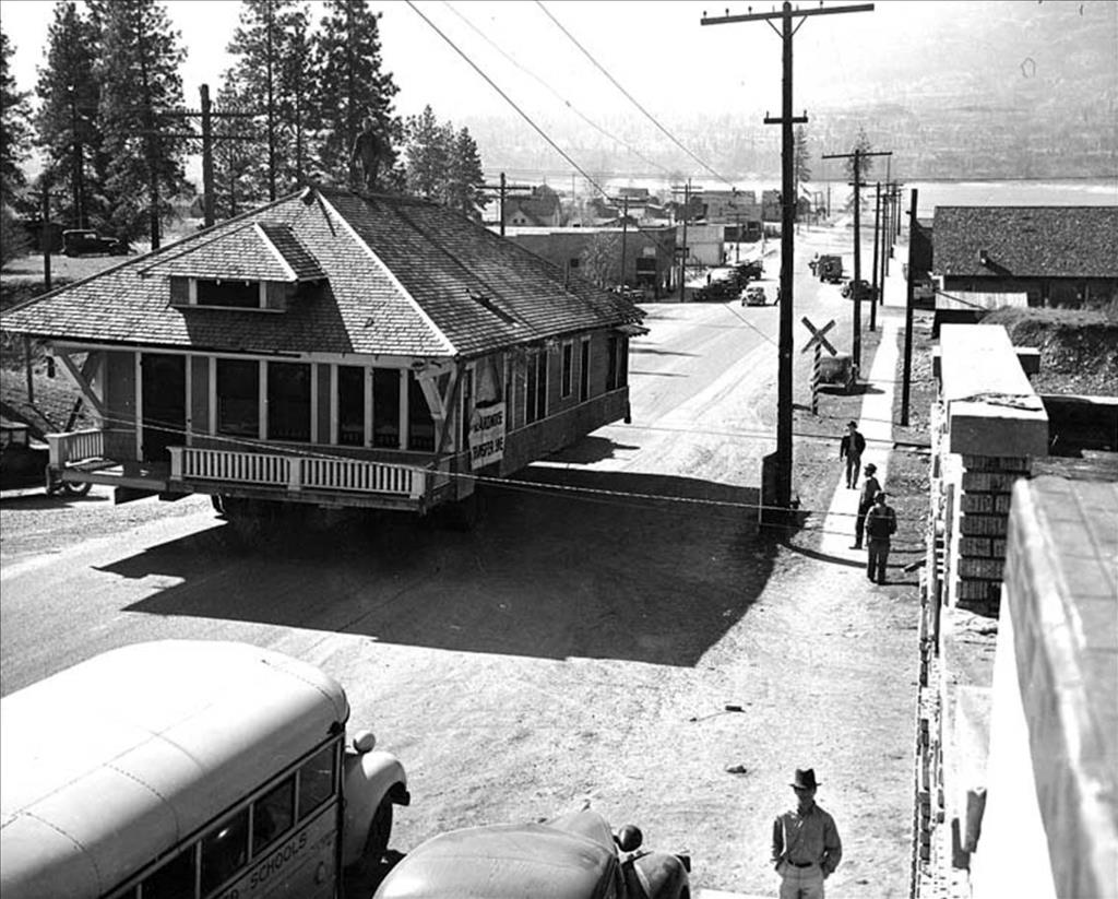
The End of Peach
Crews of Work Projects Administration (WPA) and Civilian Conservation Crew (CCC) workers began the massive task of clearing what would become the giant bed of the reservoir, Franklin D. Roosevelt Lake. Clearing the Columbia basin for the reservoir was the nation's largest single WPA project, employing more than 2,000 people. Workers established temporary camps near the areas they were clearing, moving camp when the nearby area had been stripped of buildings and other construction, trees, stumps, and anything else that might float to the surface of the future lake.
The workers who cleared Peach were stationed at Camp Lincoln, the first of an eventual six WPA camps established. Peach was the lowest town to be displaced and the first cleared. By October 1938 this work was well underway.
The United States government paid Peach settlers $5,000 for each 20 acres of land they owned. Since managing orchards was highly labor intensive and since these were family farms, many residents owned far fewer than 20 acres. Once these settlements were made, Peach residents were instructed to vacate the area by January 1, 1939.
As in other towns preparing for inundation, some homes from Peach were likely moved to higher ground. Most were left standing, and were later burned down, as were the orchards. Bureau of Reclamation policy was to burn fruit trees as soon as residents had vacated an area, fearing that untended trees would become infested with insects and these infestations would spread to orchards outside the inundation footprint. Stumps from the burned orchards were blasted out with dynamite.
By July 1939, the town of Peach was no more. Parts of the nearby town of Lincoln, including a sawmill, had been relocated to higher ground. Other former residents of old Lincoln moved to nearby Miles. Workers dismantled Camp Lincoln and moved on to Gerome.
The Displaced Dead
With what in hindsight looks like divination, Peach residents had placed one of their cemeteries on high ground, near present-day Lincoln. Burials from two other cemeteries near Peach (now under water) were moved to Peach Cemetery in 1939. These cemeteries were the W. L. Brannon Cemetery and the W. H. Balcom Cemetery. These may have been family cemeteries on private property. More than 50 cemeteries that fell within the Grand Coulee Dam/Lake Roosevelt footprint, many of them Indian burial grounds, were moved to higher ground. A Spokane funeral home, Ball and Dodd, under contract to the Bureau of Reclamation, Department of the Interior, was responsible for these grave relocations.
Other Indian burials within the Columbia Basin were relocated under the supervision of Dr. Phillip Drucker, an anthropologist from the University of California, assisted by Dr. Alexander D. Krieger, an anthropologist from the University of Oregon. A team of young men from the National Youth Administration was assigned to the project, but members of the Colville tribe objected to the removal of artifacts, temporarily bringing work to a halt. After negotiations, the work of moving graves was resumed.
In his book Grand Coulee: Harnessing A Dream, historian Paul C. Pitzer states:
"By the fall of 1940 the number (of relocated Indian graves) rose to over 1200. Indian leaders then indicated the discovery of over 2000 additional sites, with more turning up daily. The Bureau, seeing no end to the effort, stopped it entirely. Despite protests from the Colville Nation and the agreement the Bureau made with the Indians, it relocated no more graves, and water shortly rose over those both discovered and undiscovered" (p. 221).
