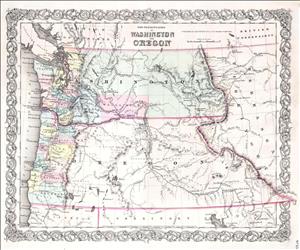
On December 22, 1852, the Oregon Territorial legislature in Salem creates Pierce County. It does so by partitioning off a portion of Thurston County. Pierce County, along with Island, Jefferson, King, Thurston, Pacific, Lewis, and Clark, becomes one of Washington Territory's original counties when Washington Territory is separated from Oregon Territory on March 2, 1853.
Thurston County, Oregon Territory, had existed as such for exactly one year before Pierce County was divided from it. Thurston County, Oregon Territory, encompassed the future King, Island, Jefferson, Chehalis, Mason, and Pierce counties, as well as (smaller) Thurston County, Washington. When Thurston County, Oregon Territory, was created it was divided into five precincts. Of these, Steilacoom precinct roughly corresponded with the boundaries of what would become Pierce County. When Pierce County was created the town of Steilacoom was designated county seat.
Pierce County was named in honor of Franklin Pierce (1804-1869), who served as United States president from 1853 to 1857. Thomas Chambers, William P. Dougherty, and Alexander Smith were appointed county commissioners. John Bradley was named sheriff, and John M. Chapman was named probate clerk.
Boundaries
Like the other early counties, Pierce County's boundaries were at first loosely stated. Over the years as non-Indian settlement in Washington Territory continued to expand, these loose boundaries were restated several times. Each time the territorial legislature took up the question of county boundaries they did so with greater specificity. The Evolution of Washington Counties, first written in 1927 and updated in 1978, explained, "The old days were passing, and the loosely drawn limits of pioneer days would serve no longer for purposes of private ownership or public control. It had been a favorite sport of pioneer legislators from the beginning to overhaul county boundaries, whenever any transient demand for such action arose. But the legislators of 1867 were in for a thorough political house-cleaning" (p. 43).
The Washington territorial legislature addressed Pierce County's boundaries four times: on January 25, 1855, January 29, 1859, January 5, 1865, finally spelling things out to their satisfaction on January 31, 1867. At that time Pierce County's boundaries were defined as follows:
"Commencing at the mouth, mid-channel of the Nesqually River; thence following the main channel of said river to its head; thence due east to the summit of the Cascade mountains; thence northerly along said summit to the head of Green Water; thence westerly down said river to its confluence with White river; thence down the main channel of White river, to the intersection of the fifth standard parallel; thence west along the said channel to the head of Commencement Bay; thence northerly along the main channel of said bay to the south entrance to Colvo's Passage; thence down the channel of said passage to the north-east corner of section 16 in T. no. 22 N, R 2 E; thence west to the north-east corner of section 16, in T. no. 22 N, R 1 W; thence southerly along the channel of Case's Inlet and Puget Sound, to the middle of the mouth of the Nesqually river and place of beginning" (Abbott and Carver, p. 112).
These boundaries (with subsequent minor adjustments) remain the present-day (2006) boundaries of Pierce County.

