On September 21, 1942, the U.S. Navy formally commissions Naval Air Station Whidbey Island. The airfield, located near Oak Harbor and soon to be named Ault Field, serves as a base to train fighter and patrol bomber crews. The operation also includes a seaplane base on Forbes (Maylor's) Point on Crescent Bay where Catalina flying boats defending Puget Sound refuel and rearm. NAS Whidbey will become Navy's principal air facility north of San Francisco and west of Chicago.
A Place for Flying Boats
In January 1941, the U.S. Navy began searching for a base to rearm and refuel Catalina flying boats -- the Navy's principal anti-submarine and reconnaissance plane -- from Sand Point Naval Air Station to help defend Puget Sound. Within 10 days, Navy officers examined Indian Island, Lake Ozette on the Olympic Peninsula, and Keystone Harbor and Penn Cove on Whidbey Island, but found the locations lacking because of mountains, sea bluffs, no beaches, and prevailing winds. Seaplanes and flying boats landed on water and taxied to docks or onto the shore.
The officers did find Forbes Point on Crescent Harbor and Saratoga Passage on the west side of Whidbey Island to be suitable. The Navy needed a spot where pilots could land relying on flight instruments, but for the most part, weather there was good and seldom foggy. The government purchased the land from the descendants of the Samuel Maylor, an early Oak Harbor settler. Part of the construction involved removal of Indian graves from Crooked Spit in order to make way for an auxiliary air field, which, however, was never built.
The Airport
Within months, little Oak Harbor was flooded with construction workers building roads, laying utility lines, and pouring concrete. In November 1941, the Navy decided it wanted an airport on Whidbey Island as well and on December 8, 1941, the day after Japan attacked U.S. Forces in Hawaii and the Philippines, three surveyors began marking out a 4,325-acre reservation northwest of town.
Clover Valley was ideal for an airfield. It was flat and airplanes could approach from almost any direction. It was also distant enough from populated areas for practice bombing. Twenty farmers sold their farms to the government. Construction started on March 1, 1942, and more construction workers and then sailors inundated Oak Harbor. Japanese seizure of two Aleutian islands, the shelling of a fort in Oregon, and the torpedoing of ships off the Washington coast underlined the urgent need for the base.
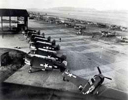
Ault Field
On September 21, 1942, Captain Cyril Thomas Simard stood on the steps of the brand-new Building 12 and read orders officially commissioning Naval Air Station Whidbey Island and, in Navy parlance, "the watch was set" (NAS Whidbey website). A year later, the airport was named Ault Field in memory of Commander William B. Ault, missing in action at the Battle of the Coral Sea in 1942.
The seaplane base saw its first Catalina in December 1942 and Ault Field became a training base for crews of Wildcat and Hellcat fighters, Ventura patrol bombers, and Dauntless dive bombers. Catalina and Mariner flying boats flew out of the seaplane base. The seaplane base closed in the late 1960s and became Navy family housing.
