On March 23, 1936, a key part of the long-lasting and challenging work to construct the Mountain Loop Highway begins. This scenic 55-mile-long road in Snohomish County will eventually (likely by late 1941) link Granite Falls to Darrington. On March 23, workers begin removing rails on the abandoned Hartford Eastern Railway line between Hartford and Monte Cristo (about midway between Granite Falls and Darrington). This will clear the way for construction of a new Forest Service road along the South Fork Stillaguamish River from Verlot east to Red Bridge and then onward toward Silverton and Barlow Pass, there linking to a section already under construction by Civilian Conservation Corps crews up the Sauk River. The Mountain Loop Highway was first suggested in a letter to the Snoqualmie National Forest supervisor dated March 30, 1932. The date the road will first be passable (although barely) by vehicles was likely in late 1941. The road will be closed to civilians in the summer of 1942 and reopened after the war.
Creating the Mountain Loop Highway
Until 1932 there was little need for a highway in the isolated section of the Cascade Mountains between Granite Falls and Darrington in eastern Snohomish County. Primitive wagon roads had been constructed to bring supplies and materials for mining and railroad construction to Monte Cristo during the early 1890s. However the little used Darrington to Barlow Pass portion up the Sauk River largely deteriorated into a Forest Service horse trail over the years.
On the more settled South Fork Stillaguamish River side from the pass down to Granite Falls the road was turned over to Snohomish County. As virtually all traffic was carried by rail, it, too, virtually disappeared. As long as the line operated, first as the Everett & Monte Cristo Railway, then as a branch of the Northern Pacific Railroad, and finally from 1915 to 1932 as the Hartford Eastern Railway, passenger and freight traffic moved fairly efficiently. Above Robe Canyon that dependability lessened sharply, however, due to frequent floods, problems with its tunnels in the canyon, and a lack of revenue sources. This was especially true after 1897, when the railroad was badly damaged and the owners let it sit idle for almost three years.
From December 1921 to July 1922 another severe flood caused closure. This prompted the U.S. Forest Service to attempt construction of its own road on the north side of the river and across from the railroad. It would run from Turlo (between Robe and Verlot) to its ranger station near Silverton, a dozen miles farther east up the valley. For 10 miles from Granite Falls to Robe, the County already had improved its section, but not into the National Forest lands. Forest Service work, however, bogged down due to competing priorities and a lack of money.
In the early spring of 1932, the situation changed drastically. A combination of yet another massive flood and the effects of the Depression on the railroad’s logging business and tourism to Big Four Inn, four miles beyond Silverton, led to a shutdown of regular service. Residents, the Forest Service, and recreational opportunities were cut off.
Getting Some Action
Intense pressure was exerted on the Forest Service and the federal government to create a Mountain Loop Highway from Granite Falls to Darrington as a way to alleviate these problems. Most active was the Roads and Highways Committee of the Everett Chamber of Commerce, chaired by attorney Perry Black. With strong backing from the Snohomish County and Seattle chambers, along with the commercial clubs of Arlington and Granite Falls and the Washington State Good Roads Association, Everett Democratic congressman (later governor) Mon Wallgren (1891-1961), local residents, and property owners demanded action.
And they got action. The railroad agreed to abandon its right-of-way, which it turned over to Snohomish County. Starting money was allocated, and by the onset of winter, 1932, a preliminary route was surveyed up the north side of the narrow valley as far as Wiley Creek.
A series of annual contracts were let, administered by the federal Bureau of Public Roads and awarded to companies generally from Seattle. Pay scales reflected the Depression. In 1933, for example, minimum wages for skilled workers were $.65 per hour, with $.55 for unskilled labor. The following year, under New Deal standards, the rates were $1.20 for skilled, $.75 for intermediate level, and $.50 for unskilled.
With a new ranger station under construction at Verlot (the present Verlot Public Service Center), the goal was for a new road to Monte Cristo. Construction was divided up into consecutive sections, spread out over a decade, and funded through separate annual contracts. Progress. however, was maddeningly slow for those dependent upon its completion. A 1935 petition to the Everett Chamber of Commerce from upriver citizens demanded more speed, noting that at the then present rate, Silverton would not be reached until 1947!
On March 23, 1936, workers began removing rails on the abandoned Hartford Eastern Railway line between Hartford and Monte Cristo. This cleared the way for construction of a new Forest Service road along the South Fork Stillaguamish River from Verlot east to Red Bridge and then onward toward Silverton and Barlow Pass, there linking to a section already under construction by Civilian Conservation Corps crews up the Sauk River. Using a crew of 12 to 20 men, removal work was managed by the H. A. Christy Company of San Francisco and the Union Steel Rail Company of Portland. The project was expected to take most of the summer.
In 1936 young men from the Civilian Conservation Corps were added to the labor force, and during the summer, construction brought the route as far as the famous “sinkhole” clay deposit at Sawyer, above Red Bridge. Keeping on into the winter, crews advanced toward Silverton. The following season an automobile reached that tiny mining community. In 1938 the first truck made it through, carrying a load of lumber to build Ted Turner’s home just west of town and unable to turn around on the narrow graveled grade until it reached its destination.
From Big Four Inn in 1939 and then onward to Barlow Pass, the highway continued almost entirely along the railway grade, with much of the labor provided by the roughly 20 Civilian Conservation Corps enrollees staying at their Perry Creek “spike” camp.
In May 1941 a touring Arlington journalist noted that only 600 feet remained until reaching Barlow Pass. He traveled over the pass past the Forest Service guard station and descended the South Fork Sauk River valley to meet the Civilian Conservation Corps crews coming up the other side from Darrington. Their route followed much of the 1891-1893 wagon road built by the Monte Cristo miners and improved above Monte Cristo Lake by the Penn Mining Company of Goat Lake later in that decade. Based at Bedal, the Sauk side fellows still had a little over two miles to finish.
Finishing up the Road
They linked up in December 1941, just in time for the wartime restrictions and closures. Access did allow Big Four Inn to be taken over by the United States Coast Guard for a temporary duty station for service men awaiting their active duty assignments, and it also finally led to an extension of the road to the Monte Cristo mines.
Following the war, money was allocated to improve road standards of the route, especially building concrete bridges, widening to two lanes, and improving grading. Above Perry Creek more of the original railway grade was bypassed, leaving a portion intact, just below Barlow Pass, where visitors may walk the “Old Government” trail and see the interpretive sign in a century-old rock cut.
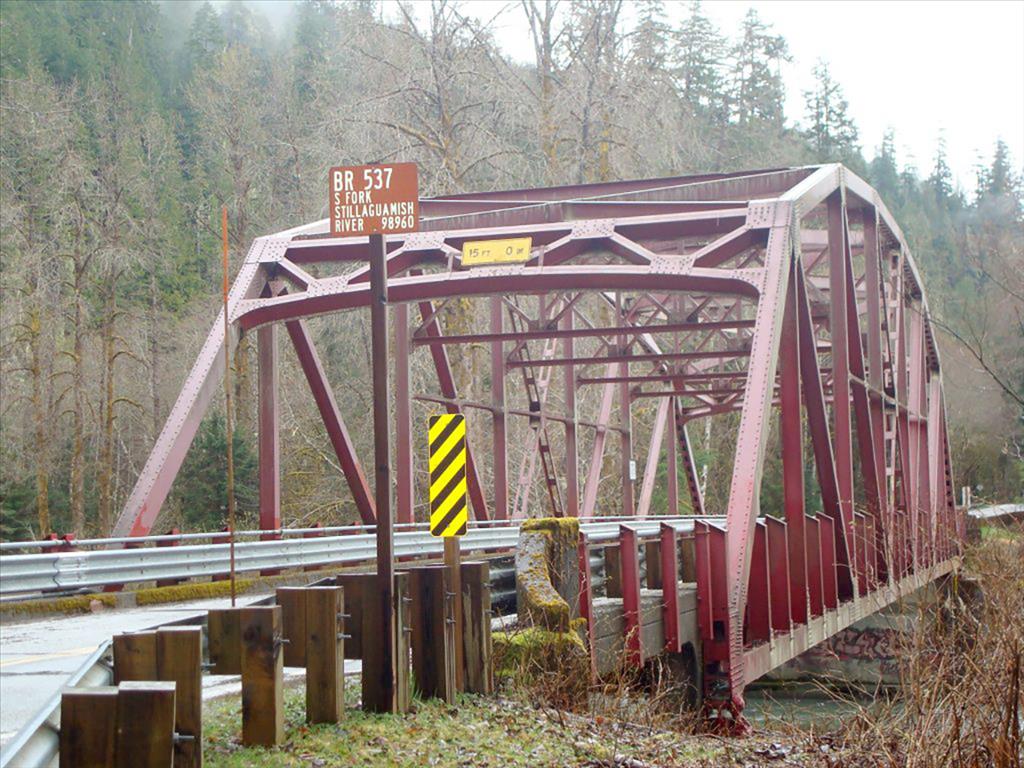
Snohomish County had opened the present steel-truss bridge at Granite Falls in July 1934 and agreed to provide highway maintenance to Barlow, which it still does. Above Verlot, the narrow 1936-era steel bridges across the Stillaguamish River to Mt. Pilchuck and the one at Red Bridge were replaced by 1955, with the road straightened to its present location and paved eventually to the pass. North down the Sauk valley to Darrington the Forest Service maintained the road.
In 1975 the Federal Highway Administration replaced the three deteriorating log bridges across the South Fork Sauk River with concrete ones. Although the portion of the road from Darrington to the Whitechuck River was replaced by a wide, paved, two-lane modern highway in the early 1980s, public reaction to a Federal Highway Administration proposal to alter the rest of the route up the river to Barlow Pass was immediate and negative. People enjoy the experience of traveling through the timber and winding along the Sauk side, and the Stillaguamish portion provides vistas, a large number of campgrounds, and the start of many popular short hikes to mountain lakes, the Big Four Ice Caves, and Monte Cristo.
For more than 20 years the flood-damaged roadway from Barlow Pass to Monte Cristo has been maintained for public access by the Monte Cristo Preservation Association.
