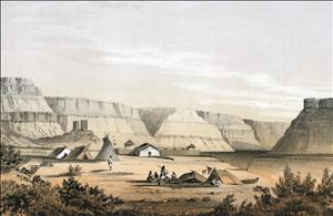
On November 17, 1859, Walla Walla County commissioners name the town that has grown up around the U.S. military Fort Walla Walla. They elect to name the town Walla Walla. The town begins with a rich history, which includes Native North Americans, fur traders, missionaries, soldiers, and pioneers. Walla Walla's earliest businesses are raising cattle and supplying the fort. The town will be incorporated and become the county seat in 1862. A gold rush followed by a growing agricultural industry will help Walla Walla become the largest city in Washington Territory by 1880. During the twentieth century, Walla Walla will continue to develop as an agricultural center for various crops, including wheat, onions, apples, peas, and wine grapes.
The Time before the Town
“Walla Walla” was a Nez Perce name given to one of the indigenous groups who lived in what is now the Walla Walla Valley. The name means “running waters” or, more specifically, the place where a small stream runs into a larger one. A number of rivers flow across the valley into the Walla Walla River and join the Columbia River. In addition to the Walla Wallas, native North American groups who lived in this area included the Nez Perce, the Cayuses, and Umatillas. In 1806, the Lewis and Clark expedition camped near the mouth of the “Wallahwollah river” on the Columbia and encountered the “honest and friendly ... Wallah wallahs.”
In 1818, near where the Lewis and Clark party had camped, the North West Company set up a profitable trading post called Fort Nez Perces. After the North West Company was absorbed by the Hudson’s Bay Company in 1821, this post came to be known as Fort Walla Walla. East of the fort, and about 10 miles west of present-day Walla Walla, French Canadian fur traders settled in an area that came to be known as “Frenchtown.”
In 1836, Presbyterian missionaries Marcus (1802-1847) and Narcissa Whitman (1808-1847) arrived in the valley to establish a mission among the Cayuses. The mission site, Waiilatpu, was situated on the Walla Walla River about seven miles west of present-day Walla Walla. After the Whitmans and others were killed by a group of Cayuses in 1847, the Cayuse War was fought in the area. After Washington became a U.S. territory in 1853, and after Governor Isaac Stevens (1818-1862) held a treaty council with Nez Perce, Yakima, Umatilla, Walla Walla, and Cayuse tribes in present-day Walla Walla, more conflicts followed. In 1856, after Stevens called a second unsuccessful treaty council, Lieutenant Colonel E. J. Steptoe (1816-1865) set up a fort in what today is downtown Walla Walla. The fort took the name of the abandoned Hudson’s Bay Fort Walla Walla.
An Agricultural Center
By 1859, the local Indian Wars had ended, tribes were forced to relocate to the reservations established by the treaties of 1855, and the land east of the Cascades was declared fully open for settlement. A small collection of cabins, shacks, and tents were situated near Fort Walla Walla, which had become a permanent military station for U.S. troops and moved into new quarters southwest of the future town’s center.
Walla Walla County had been organized by the territorial government in 1854, but no provisions were made for its government until 1859. In 1859, commissioners were appointed, elections for new commissioners were held, and the town emerging around Fort Walla Walla -- which had previously been known as Steptoeville and “Wailetpu” -- was named Walla Walla. Surveying, platting, and the sale of lots followed. The town was officially incorporated as a municipality and declared the county seat in January 1862.
In 1861, the small town of Walla Walla benefited from the discovery of gold in the eastern part of the county (now Idaho). A booming market for provisions, equipment, and animals brought farmers, merchants, ranchers, and others to the town. When the gold rush was over, Walla Wallans shifted their attention to the success they had experienced with farming and the town emerged as a center of agricultural production. Wheat was the principal crop; other successful crops were apples (which reached their peak in the 1920s), peas (which reached their peak in the 1960s), and grapes (wine grapes became significant for the region at the end of the twentieth century).
By 1880, Walla Walla was the largest city in the territory. It was home to one of the oldest newspapers in the region, the Washington Statesman (which first appeared on November 29, 1861), and one of the oldest institutions of higher education in the region (Whitman College, which grew out of an institution chartered in 1859 and started in Walla Walla in 1866). It was the site of the Washington State Constitutional Convention in 1878.
After it was bypassed by the transcontinental rail lines in the 1880s, Walla Walla’s growth was more modest but steady. It became the site of the territorial prison in 1886 and during the twentieth century it became the location of a veterans' hospital (1921), a bomber air training base during World War II, and a district office of the U.S. Army Corp of Engineers (1948). By the end of the twentieth century, Walla Walla had become the center of a burgeoning premium wine industry.

