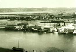
On January 29, 1912, the Tacoma Commercial Club & Chamber of Commerce unveils a plan for the Tacoma harbor prepared by engineer Virgil G. Bogue (1846-1916). The plan lays out a development plan for the entire waterfront. In 1912, it has become glaringly obvious that a plan is needed to develop the part of the waterfront not controlled by the Northern Pacific Railroad, primarily the area east of the Puyallup River. Numerous private landowners, many of whom managed to wrest the land away from Puyallup tribal landowners in the late 1890s, have filed plats for their parcels in recent years, creating a disorganized and ineffective ad hoc development plan. Bogue's plan proposes the development of three waterways, an industrial district, and a motor boat and yacht harbor, along with the creation of a port-improvement district, through which the plan can be carried out and landowners taxed for their portion of the estimated $3.8 million cost. Local landowners reject the plan because they perceive that some individual landowners will benefit more than others. The harbor will continue to develop according to the abilities and plans of individuals and businesses until 1918, when the public Port of Tacoma is formed.
The Tacoma Waterfront
The need for a comprehensive plan emerged in the 1890s as Tacoma's economy grew and more people wanted access to the waterfront, which was mostly owned by the Northern Pacific Railroad for the terminus of its transcontinental railroad. The City could not even build a public wharf to accommodate the steamers of the "mosquito fleet" that plied the waters of Puget Sound carrying passengers and farm produce until the railroad granted a space for it. A number of property owners, including a group that cooperated in what historian Caroline Gallacci describes as a syndicate, had managed to gain control of land from Puyallup tribal landowners east of the mouth of the Puyallup River. These landowners file a number of plats, none of which coordinated with each other.
Although the harbor had promising attributes, most importantly deep water throughout, the area needed to be developed with wharves, dredged waterways, and roads. The scope of the necessary improvements required a tremendous investment and a coordinated effort, neither of which the individual property owners could achieve on their own.
In 1911 two separate associations, the Wapato Association and the Hylebos Association, formed to develop waterways where creeks entered the bay. The Commercial Club & Chamber of Commerce met with the two associations and they concluded,
"that harbor improvements, or plans for such based on future needs, embraced a work very much broader than the interests of any individuals or of the property owners in any particular locality, and that as Tacoma's principal commercial organization, the Commercial Club and Chamber of Commerce was the logical body by and through which such plans should be made" (Gallacci, 314).
To that end, the Chamber of Commerce hired engineer Virgil Bogue, who had engineered several railroads in North and South America and created the Bogue Plan for Seattle, to create a comprehensive plan for the waterfront.
Virgil Bogue's Plan
Unveiled to the public on January 29, 1912, the plan encompassed the area from Point Defiance to Brown's Point and also recommended a drydock facility at Steilacoom, around the bend from Commencement Bay. Bogue identified five districts, each with a separate focus. The area east of the Puyallup River would have three waterways: Hylebos, Wapato, with the south waterway branching off of it. The city district, that area between the Puyallup River and the City Waterway (today's Thea Foss Waterway), would have waterfront improvements and improved street access. The Stadium district, running from the City Waterway to Old Town, would be developed for industrial and warehouse uses. Bogue planned a yacht and motor boat harbor for the Point Defiance Park district, in keeping with its existing recreational uses. Finally, Bogue recommended that a drydock be built at Steilacoom, where Chambers Creek enters Puget Sound.
According to the Tacoma Daily Ledger, Bogue argued for:
"... the formation of a port commission and it is indicated that this will lead ultimately to public ownership, control and operation of the entire waterfront and its equipment, and such ownership and control, he says, has been the success of the world's largest ports" (Bogue Plan is Made Public, 1).
The plan failed to garner enough support to move forward. Historian Gallaci blames the failure of the plan on the Chamber of Commerce waiting until after the plan was proposed to begin working to gain public support for it. Furthermore, some of the landowners felt the plan unfairly benefited some more than others.
A public port would come to the Tacoma harbor, but not until 1918 when voters approved the formation of the Port of Tacoma.

