On June 1, 1909, University Boulevard opens in Seattle between Washington Park Boulevard (now a portion of Lake Washington Boulevard) and the south entrance of the Alaska-Yukon-Pacific (A-Y-P) Exposition, the world's fair held on the University of Washington campus from June 1 to October 16, 1909. In 1903, John C. Olmsted (1852-1920) had prepared a plan for Seattle's parks and boulevards system, including a ring of boulevards connecting Seattle's major parks. The first boulevard to be built ran along Lake Washington from the Mount Baker neighborhood to Washington Park. In preparation for the A-Y-P, the Parks Department built an additional segment that crossed the Montlake Portage and ended at the A-Y-P's south gate. (The Lake Washington Ship Canal, built in 1916, had not yet bisected the strip of land connecting Capitol Hill to the University District.) The boulevard made it possible for visitors to drive along the scenic route to the fair and a new streetcar line provided access to the fair from downtown. Olmsted's plan called for the boulevard to run through the university campus and connect with what is now 17th Avenue NE, and then continue from there to Ravenna Boulevard. After the A-Y-P, the University of Washington Board Of Regents declined to allow the road to cross campus, so the boulevard followed a different route along the shore of Lake Washington on land owned by the state. Montlake Boulevard, as it is now known, is today a segment of State Route 513. The landscaped center strip is owned and maintained by Seattle's Department of Parks and Recreation.
Olmsted's Vision
In 1903 Seattle's Board of Park Commissioners invited John C. Olmsted of the Olmsted Brothers landscape architecture firm to design a plan for Seattle's park system. He created a plan that sprinkled neighborhood parks throughout the city, such as Salmon Bay Park in Ballard and Leschi Park on Lake Washington. He also laid out larger parks, such as Volunteer Park and Woodland Park, and connected them with a 50-mile-long ring of landscaped boulevards. The first of these to be built, Lake Washington Boulevard, followed the shore of the lake and provided drivers with stunning views of the lake and mountains.
As planning commenced for the A-Y-P Exposition, many city agencies worked to prepare the city for the expected crowds. According to the Board of Park Commissioners annual report for 1909, "Special efforts were made and heavy expenditures were required in carrying out our plan to have our north and south chain of boulevards along or overlooking Lake Washington from the Mount Baker district, north to the Exposition grounds, open for traffic, so that our Eastern visitors might enjoy the beauties of our lake and mountain scenery" (Sixth Annual Report, 67)
University Boulevard, also referred to as the University Extension, connected Washington Park to the campus, across the forested Montlake Portage, where Lake Washington Ship Canal and the Montlake neighborhood are today. It also provided a route for the new streetcar line connecting downtown with the university campus.
After the Fair
Olmsted had intended for the boulevard system to incorporate the University of Washington campus as one of the system's parks, with the boulevard continuing through the campus and connecting with what is now 17th Avenue NE. After the A-Y-P, the regents rejected the plan to run the boulevard through the campus. Instead, the state opened up land along the Lake Washington shore (the lake had not yet been lowered by the 1916 construction of the Lake Washington Ship Canal, and the lake shore reached up to where Montlake Boulevard runs today). The boulevard ran north to 45th Street and then curved toward the Laurelhurst neighborhood.
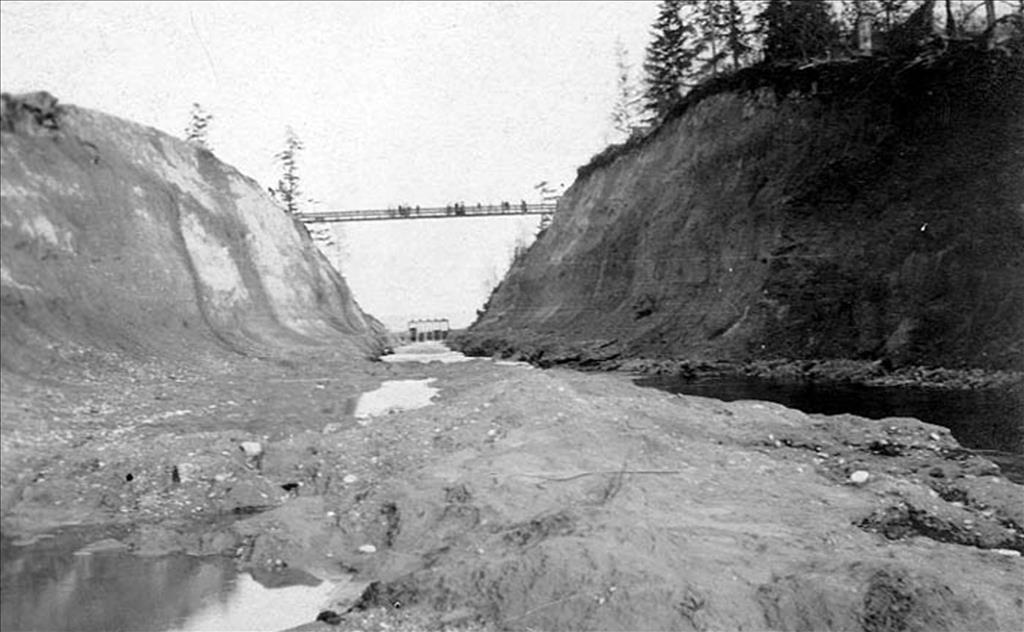
In 1920 the Parks Department completed connecting the various sections of parkway along Lake Washington into one boulevard, Lake Washington Boulevard, running from Seward Park to the Montlake neighborhood. It ended at its intersection with Montlake Boulevard, which ran north to the Montlake Cut. For several years during the construction of the ship canal, vehicle traffic could not actually cross the Montlake Cut. Instead, a footbridge connected the northern and southern sides of the Cut until the bridge opened in 1925.
Montlake Boulevard did not ever connect to Ravenna Boulevard, though they are linked by other city streets. In 1937, Montlake Boulevard became part of Secondary State Highway 1J, connecting Lake City, Sand Point, the University District, and downtown Seattle with Highway 99. In 1964, it became State Route 513, connecting those same areas with Interstate 5 and ending at the 145th Street NE interchange. The Department of Transportation shortened State Route 513 in 1991 and it now runs from State Route 520 to the Sand Point neighborhood.
The boulevard remains a part of the city's parkway system. Although the Parks Department does not retain ownership of the street, it maintains the center strip plantings between State Route 520 and the Montlake Bridge.
