The Town of Index is a riverside hamlet in the shadow of 5,979-foot Mount Index in Snohomish County. It is hemmed in by the north fork of the Skykomish River along its southern boundary, and by a steep granite cliff, the Town Wall (1,000 elev.), at its northern edge. The area was home to the Skykomish People before European immigrants came to mine the surrounding mountains and log the heavily forested valley bottom. The granite wall that serves as a backdrop to the 10-block-long, two-block-wide residential and business area became a third contributor to the economy when a large quarry was established in 1904. Thus mining, logging, and quarrying became the diverse bulwarks of the town's prosperity early in the twentieth century. At its height in 1905, the town's population reached 500, with perhaps a thousand more in the surrounding area. A fourth industry, recreation-based tourism, was established early on, and, with the loss of mining, quarrying, and logging in the 1930s, recreation became the prime means of employment. It remains so to this day, with a much reduced population of 157 that has maintained a strong sense of community.
First People of the Valley
The Treaty of Point Elliot, signed in January 1855 at Mukilteo, created a single reservation at Tulalip (northwest of Everett) for the indigenous peoples living along the Snohomish, Skykomish, and Snoqualmie river basins. That was the beginning of the end for the Skykomish People, the extended group of families for whom the river was named, for there are no people left who identify themselves as purely Skykomish.
Seven village sites existed between present-day Monroe and Index at the time of white contact in the 1850s. Easternmost was the village near the confluence of the south and north forks of the Skykomish River. Here the members of the Skykomish group were called the fern people, not surprising in an area with an average of about 100 inches of rain per year. A large potlatch house was located here in a permanent winter village site named “xa’xausalt,” taken from “s’xaus,” meaning a saw-bill duck. Elders of the tribes that settled at Tulalip told anthropologist Colin Tweddell that “The Index people were the genuine Skykomish tribe, rather wild; they would come up in canoes and suddenly [be] gone, hid in the rocks by Index ...” (Tweddell, 150).
White Immigrants Enter Skykomish Territory
By 1890 when the Town of Index’s founding family, the Gunns, arrived from Kansas, the Skykomish people already had witnessed many prospectors passing through on their way into the heart of the mountains. As early as 1859 Emory C. Ferguson (1833-1911) and Edson Cady (b. 1828) had trekked past the future townsite, to a mountain pass, a route that had been used by the Skykomish as they visited and traded with tribes on the east side of the Cascades.
Ferguson and Cady named the spot “Cady Pass,” but were blocked by heavy snow from continuing their search for a new route to gold fields of the Similkameen River. In the spring they returned to improve the route, but mining in Eastern Washington had died out, and the plan was abandoned.
The Search for Mineral Wealth
In the late 1880s prospectors looking for gold, silver, lead, and copper followed Ferguson and Cady’s rough trail on their way to the mining areas of Silver Creek. By April 1890, Amos D. Gunn (1843-1907) and his wife, Persis (d. 1898), had purchased a squatter’s claim which held a small log cabin serving as a miners’ hotel, “Cady Lodge.” They constructed a larger building and became the primary hostelry and supply depot for those heading east to the towns of Galena, Mineral City, and Monte Cristo.
Persis Gunn was impressed by Index Mountain, which looked to her like an “index finger pointing toward heaven” (Gunn video). Through her influence the name “Index” was chosen when a post office was established in December 1891. The original “Index Mt.” (Weaver, 41) was on the maps long before the Gunns arrived. It does look like an index finger if viewed from the west, but it was renamed Mount Baring in 1917, and the mountain to the west, called “West Index Mt.” (Beckey, 32) was renamed to Mount Index. This confusion fed a long-held myth that the Gunns named the town after the current Mount Index.
The Gunns’ settlement prospered not only through the need for lodging and supplies by the miners, but because of the 1890 surveys for the Great Northern Railway. John F. Stevens hired Amos and his son Luther (1876-1963) for horse-packing a survey crew up to Cady Pass in tandem with Stevens's survey of Stevens Pass that was ultimately chosen for the transcontinental line. Track building from 1891 through 1893 added to the influx of laborers needing accommodations.
Boom-Town Gains Solidity
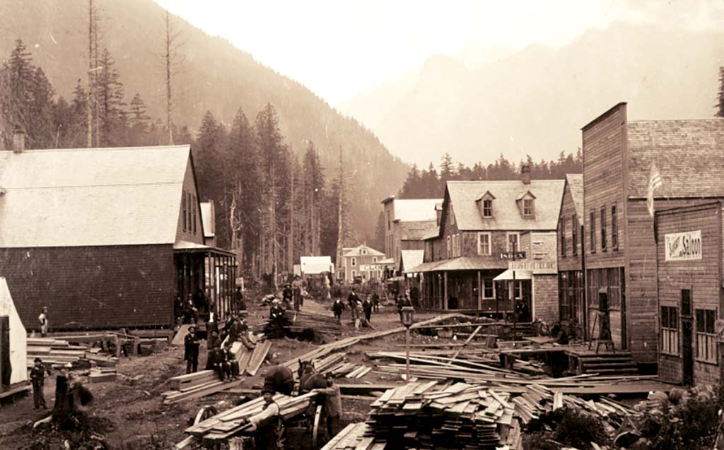
On April 25, 1893, Gunn platted the Town of Index. His hotel and packing business had prospered, and he was selling lots from $25 to $50 each. According to his daughter Persis (1880-1963), “The population had grown to 500, ... a tent hospital had been established and ... that year my sister, Lena Gunn [1874-1963] taught the first school in a room of a private home” (As Told ... 90). Hopes were high enough that Gunn platted one street exceptionally wide at 100 feet to accommodate an expected rail line to go over Cady Pass. The line never was built.
In July 1893 the Gunn hotel burned to the ground, spreading fire to every other building, excepting the train depot. A new Hotel Index was built with a small store included. However, two sources of revenue were ending -- the main line of the Great Northern Railway was finished and the financial panic of 1893 halted many mining efforts in the Silver Creek area. Monte Cristo was no longer reached via Index since a new route had been opened 11 miles north along the South Fork Stillaguamish River. In a 1959 interview Luther Gunn remembered, “’94 was hard times. Oh yes, it was hard times ... because so many men were out of employment with their work finished” (Gunn, 11).
By 1898 the discovery of the Copper Bell and Sunset copper mines ended those hard times. Index was booming, with 800 to 1,000 prospectors coming and going at one time or another. R. Frank Niles (b. 1866) came in 1899 to print the Index Miner, a four-page weekly paper published by Charles W. Gorham (b. 1865) of Snohomish. Niles recalled:
“Index was in the throes of a wild mining boom. The town was crowded with prospectors, men working on some of the mines being opened up and the usual riff-raff and promoters and grafters. ... The one hotel had men sleeping in the hallways and wherever there was a chance to lie down.
“While the boom was at its height, new buildings were being started, new mining companies were announced, and mines located every day; many of these 'mines' had not the least trace of minerals. ... The most ambitious mine was the Sunset, six miles upriver from town. It was owned by a bunch of farmers from the big marsh between Snohomish and Lowell. They ... proved a flop as miners. They built a tram road to Index, including a bridge across the Skykomish, and then started shipping ore to the Everett smelter. ... that did not pay the expense of sorting it. They soon went broke and the mine shut down, and the boom — what was left of it collapsed. It is hard to imagine what a gloomy dejected town Index became overnight when the bad news hit” (Niles, 2-3).
Although The Index Miner trumpeted: "What Butte is to Montana, Index Will Soon be to Washington” (Miner, p. 1), all that remained in 1901 was a small-scale granite quarry east of town, a general store, two saloons, an assay office, a drugstore, and a single sawmill that had been constructed to saw ties and bridge timbers for the new railroad.
Logs, Shingles, and Granite
In 1903 and 1904 two men turned the mood back to optimism. “Aided by the recent arrival of the Great Northern Railway to the town of Index, Sylvester Smith recognized a good location for logging and, in 1903, built a large combination saw and shingle mill near town. The sawmill had a capacity of 40,000 feet per day and the shingle mill a capacity of 30,000 shingles per day. The mill also contained an electric lighting plant of sufficient power to supply the town ... . Between 40 and 50 men were employed year round ... making it the largest employer of the area at that time” (Robbers, 5). The small sawmill in town quit operating.
The other man who helped stabilize the economy was John A. Soderberg (1866-1935), general store owner in 1900, who in 1910 also became President of Swedish Hospital in Seattle. In 1904 he began developing the Index Granite Company, a large quarry along the Great Northern tracks three-quarters of a mile west of town. Seventy men were employed there most of the time, supplying material for construction of prominent buildings in Seattle, Spokane, and Everett, including the State Capitol in Olympia. Soderberg also provided the town’s first piped spring water, a welcome service since before this the town had battled its second major fire two years without a water system.
In 1905, in addition to the promotion for mining, some investors were planning hydroelectric development. Two dams on the North Fork Skykomish River were promoted, but never begun. A plan for generating electricity from Sunset Falls on the South Fork, as well as putting in a major pulp mill there, had interest, but no completion.
Fishing, Hiking, and Climbing
A 1905 promotional brochure calls Index “One of the scenic spots of the world, with sublime rugged peaks and wonderful waterfalls ... . A popular summer resort among eastern people” (Brochure, 1905). The fishing was great, according to Frank Niles of the Index News: “I walked from the back door about 60 feet to the river and in a distance of perhaps 40 rods [660 feet] I caught 45 trout” (Niles, 6). As a result, hundreds of tourists came by train, stopping at one of five hotels operating at that time.
Most people went hiking and fishing, but the more adventurous, such as members of The Mountaineers, would carry out expeditions to climb surrounding peaks. Lee Pickett (1882-1959), a professional photographer who lived in Index, captured images in 1911 showing a long line of climbers, including women in long skirts, on Mt. Index, trudging upward with alpenstocks.
Copper, Stone, and Lumber
The Sunset Copper Company re-opened in 1902 under new owners, making it a primary employer until 1935. The business flourished when the demand for copper increased because of World War I. The work attracted men with families who, unlike the earlier miners, would become permanent citizens of the town.
Soderberg’s quarry brought workers and stone artisans with their families from as far away as Barre, Vermont. Photos show intricately carved, highly polished tombstones waiting for shipment. Bert Spada (1896-1985) reminisced: “In 1912 they put in a polishing machine -- you know before that they used to rub them by hand -- polish them just like glass” (Spada, 1985). In 1927 new owners continued as Western Granite Company.
The Smith mill was sold in 1908 to a partnership which greatly expanded and improved the operation and re-named it the Index-Galena Company, employing an average of 150 men at its peak. Assets included two Climax steam engines and the rail cars to haul logs as far as 16 miles down the North Fork Skykomish valley to the mill. Another mill on the South Fork Skykomish had been started by Louis Heybrook, though in comparison it was a small-scale operation.
Families of these workers needed the social stability that the town offered -- a school, hospital, church, and organizations such as the Fish and Game club and the Independent Order of Odd Fellows (I.O.O.F.). The Red Men, a fraternal organization dating from the Boston Tea Party, and restricted to Caucasians only, shared a two-story meeting hall with the I.O.O.F. That hall, built in 1903 and including a stage and a kitchen, hosted everything from touring vaudeville shows to town celebrations.
There was full political participation when the town incorporated in 1907, with a Mayor/Council government paying for a town clerk, law enforcement, and a maintenance man, with volunteers manning the fire department. A new two-story school was planned, opening in 1908.
A major challenge to the budding town was periodic flooding. Many homes and businesses were built right on the riverbank, only slightly protected by wooden cribbing. The flood of 1917 was especially devastating, taking with it not only many homes and businesses, but the recently built bridge across the raging river. Floods would continue to cause loss throughout the century.
From Railway to Highway
Coming to town by river, as pioneers did in many Snohomish County communities, was never a possibility for Index settlers. The river was too swift and hazardous for navigation by steamboat. Early pioneers came by horse on rough trails until the Great Northern Railway was completed in January 1893. Then transcontinental trains and two locals called “Dinkies” provided reliable transportation. The depot was literally at the center of the community.
The county road to Index and Galena was completed in 1911. As autos were developed and roads expanded, including Washington's first “Scenic Highway,” following the 1911 road directly through town and competition from the Index Stage Company became serious. That bus service lobbied to expand its route to the top of Stevens Pass via the new highway to Wenatchee that opened on July 11, 1925. Once the extension was granted, the Great Northern stopped service of the beloved “Dinkies,” which had delivered postal bags and passengers every morning and evening except Sundays.
Industry Dies, Recreation Survives: The Great Depression
In May 1932 the quarry shed with its massive crane burned, leaving unmovable stones inside the building. The shed was never rebuilt and the remaining broken blocks were ground and sold as chicken grit. Depression gripped the economy, and failing banks would not finance what had become obsolete technology. A relatively new material, reinforced concrete, was recognized as far cheaper for structural use than quarried granite. Families began moving away, leaving a new three-story high school with a dwindling student population.
Frederick Carlson reminisced, “In 1929 the mill pond had no logs and the mill shut down. No mill crew, no steam ice plant, no steam for [the] engine” (Carlson, 2002). Miller Logging Co. moved its operations to Index in 1936 and put a million dollars into re-opening the Index-Galena mill’s route up the North Fork Skykomish to haul logs down to the Great Northern mainline. However the effort did not pay and by 1939 logging ground to a halt. The forest of Heybrook Ridge, with the Index-Galena mill on its north side and tiny Heybrook Lumber Co. on its south, had been clear-cut and was not re-planted. For miles around town and up the valley to the east, the trees simply were gone.
The Sunset Copper Mine shut down haltingly during the 1930s and 1940s. Copper ore was beginning to be harder to find than gold and the ores found were of lesser quality. Although in any other decade gold might have been eagerly sought, War Order L208 banning the mining of non-essential metals made it impossible to extract that precious metal. In 1935 miners took over the operation in frustration, having been denied their wages by management. They worked only until 1940 to extract the value of the pay owed to them. Bond holders kept the mine open for a short period, but production ended in 1946. Buildings and equipment sat unused for another 30 years before the remains were either burned or sold for scrap metal.
A Civilian Conservation Corp. (C.C.C.) camp a quarter mile east of town brought many young men from the east coast to the area in 1934. They helped build Troublesome Creek and San Juan Campgrounds for the U.S. Forest Service as well as improving miles of roads and forest trails, but were gone by 1940 when the program ended.
A major blow was the reconfiguration of State Highway 2 in 1933 to bypass Index. That change in the cross-state route meant that one had to make a sharp turn-off and drive another mile before reaching the sleepy little town. More businesses closed, but recreation continued as a mainstay for keeping the town viable.
People still came through on their way to Index-Starr Hot Springs, later called Garland Mineral Springs, 14 miles east of town. It was a major resort with bathing pools and cabins that continued to prosper throughout the Depression. Often visitors stopped at the one remaining hotel in town, the Bush House, on their way farther east. During World War II, Garland was used as a Coast Guard training camp, bringing many men to Index who patronized the few remaining businesses, especially the tavern and the post office.
Stagnation Followed by Fire
On a hot August day in 1939, a spark from a train west of town caused a devastating forest fire. Winds blew hot cinders eastward to land on dry shingle roofs. The wood-framed schools were saved by volunteer firefighters, but the church and seven residences succumbed. It was a depressing end to a depressing decade.
The late 1940s through the 1970s saw a town in a reduced state. Buildings left for the public included one store, a tavern, the Red Men’s Hall, fire station, city hall, and the Bush House Hotel. High school students had transferred to Sultan in 1942, and the beautiful wood-framed schools were demolished in 1955. Only the replacement, a cinder-block grade school, remained. In 1961 fire destroyed the resort at Garland.
In 1962 the sharp curve of the railroad tracks was widened and the grade raised above street level, effectively cutting the town into two parts, each hidden from the other. In that project the railroad depot -- treasured by the people, but unnecessary because trains no longer stopped in Index -- was destroyed.
The Daughters of Pocahontas (Red Men’s auxiliary), church, and Sportsmen’s Club survived as well as the Community Club, which supported school activities and a Boy Scout troop. People supported the annual town picnic, Halloween and Christmas parties for the children, and in 1976, a revival of an Independence Day Parade.
Excitement and distraction were provided by a seven-car, non-injury train derailment in 1981 and in 1984 by the drilling of a 200-foot tunnel into the granite quarry wall. The Robbins Company was testing a drilling machine destined for a diamond mine in Australia. The broad entry was then closed and the tunnel leased to the University of Washington for physics experiments deep underground.
The New Century: Fishing, Kayaking, Rafting
Although the fishery has declined, winter visitors and locals still wade deeply into the river to catch elusive steelhead trout. By late spring fishing nearly ceases as hundreds of rafters and kayakers put their crafts into roiling whitewater. Professionally guided river trips originate in town, and clients often stay in nearby bed-and-breakfast establishments, providing needed tax revenue. Nearly half the town’s residences are now used seasonally. The tavern and Red Men’s Hall are gone, but skiers, rafters, cyclists, and mountain climbers help the single general store to stay in business. Cottage industry brings some revenue, but most workers commute to other locales. There is a need for more overnight accommodations since the hotel closed, and Forest Service campgrounds are inaccessible because of flood damage. Deep budget cuts by the U.S. Forest Service and Snohomish County have delayed campground and road repairs.
Still, the strong spirit of community comes forth when needed, most visibly when sandbagging for a flood. The 1980, 1990, and 2006 floods saw volunteers laboring to save homes while watching upriver cabins float, broken, under the bridge. They could not protect them all in 1980, nor could they keep the road and waterline from having to be replaced.
Heybrook Ridge and Town Wall
In 2008 citizens rose to the challenge to save nearby Heybrook Ridge, with its 100-year-old forest, from another clear-cutting. Townspeople and visitors from around the region banded together to raise money to buy 139 forested acres. Matched in funding by Snohomish County, they helped create the county’s newest park, a recreation and interpretive area that will attract both hikers and school classes.
Washington State Parks now owns the granite Town Wall, a nationally known rock-climbing area, which once had the quarry at its base. With the passage of the Wild Sky Wilderness Bill in 2008, which puts much of the land north and east of Index under federal protection, in 2009 Index has become the gateway to thousands of acres of forest recreation and once again “on the map” in the minds of the public, just as it was over a century ago.
