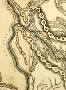
In early September, 1811, Canadian explorer David Thompson (1770-1857) travels from Kettle Falls to Boat Encampment on the Columbia River, where he completes the first scientific survey of the entire length of the Great River of the West. Boat Encampment is located in British Columbia at the mouth of the Canoe River, at the hairpin bend where the Columbia turns south. (Today the site lies buried beneath Lake Kinbasket, behind Mica Dam, north of Revelstoke, B.C.) In addition to his scientific work as a geographer, Thompson is the fur agent in charge of the Columbia Department of the North West Company of Canada. He is on a mission to determine whether the Columbia is navigable from its upper reaches to the sea and whether it will provide a viable trade route for the fur company.
Paddling North from Kettle Falls
After constructing a cedar canoe at Kettle Falls in late August 1811, Thompson put into the Columbia on the morning of September 2, paddling upstream on the only stretch of the river he had not yet charted. A group of Sinixt (also known as Lakes) people accompanied the Nor'Westers past outcrops of "hard whitish rock," where decades later miners would quarry limestone and dolomite. The voyageurs struggled through Waneta Rapid at the present Canadian-American border, then negotiated turbulent waters at the mouths of the Pend Oreille and Kootenay rivers, whose upper reaches Thompson had explored during his four years west of the Divide.
Here the men were relieved to purchase fresh fish from a Sinixt village, for their diet of dried salmon and berries was making them somewhat ill. A Hawaiian worker named Coxe had joined the crew during their sojourn on the lower Columbia, and Thompson watched as the islander absorbed the unfamiliar landscape:
"He had lived wholly on an Island, and knew its extent, but had no ideas beyond it, as we proceeded up the River, and passed the great branches, the stream became lessened, and not so wide, as he did not know from what cause, every day he expected to get to the end of it; as we approached, the cold increased, and the first shower of snow, he was for some time catching in his hand, and before he could satisfy his curiosity it was melted: the next morning, thin ice was formed, which he closely examined in his hand, but like the snow it also melted into water, and he was puzzled how the snow and ice could become water" (Thompson, Travels iii.303).
During the journey north, Thompson tracked an ongoing celestial event: "Obsvd a Comet this evening, we had seen it these few nights past, but having a cloudy hilly horizon took it for a misty cloud then" (Thompson, Notebook 27). Contemporary European astronomers called this the Comet Flaugergues, which at its brightest appeared at magnitude 1-2, with a tail 12 degrees in length. For several weeks, this spectacular object lit up the northern latitudes; its closest approach to earth was on September 12, 1811.
That same night, the Nor'Westers put up early after a long day of lining the canoe up a strong stretch of current and portaging around a set of rapids known as the Little Dalles. Another day's travel brought them to the more treacherous Dalles des Mort, where the men tracked the boat along the shore with great difficulty.
Four days later, on September 18, after drying their tent and gumming the canoe, the Nor'Westers set off at 7:15 a.m. Around midday, after recording a marathon set of 16 compass courses in his journal, Thompson noted their arrival at the mouth of the Canoe River and saw the hut he had built there after crossing Athabasca Pass the winter before.
Missions Accomplished
This landmark signaled the successful completion of his mission -- he had now traveled every inch of the Great River of the West, and had learned that it was navigable from the Rockies to the Pacific. The dream of a transcontinental trade route was now a reality, and the route that he pioneered across Athabasca Pass and down the Columbia to the Pacific served as the Northwest Passage for the rest of the Canadian fur trade's reign.
Thompson's arrival at Boat Encampment also symbolized another personal accomplishment for the surveyor: he had just completed the first scientific survey of the entire length of the Columbia, and his notebooks contained thousands of notations of course and distance that he would later transform into the first accurate maps of the Great River's sinuous course.

