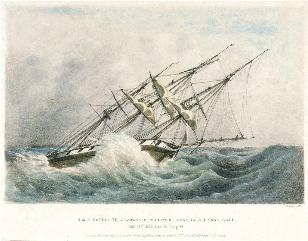
On June 27, 1857, American and British commissioners of the International Boundary Commission meet on board the British ship HMS Satellite, anchored in Esquimalt Harbor on the southeast coast of British Columbia’s Vancouver Island. The purpose of the meeting is to discuss commencing the work necessary to mark the boundary between the United States and what is then known as British North America along the 49th parallel from the Strait of Georgia to the summit of the Rocky Mountains, a distance of about 410 miles.
Two Commissions in One
On June 15, 1846, the United States and Great Britain signed the Oregon Treaty, which made the 49th parallel the boundary between the United States and British North America (it would not become known as “Canada” until 1867 -- and British Columbia would not join the new country until 1871) from Point Roberts east to the crest of the Rocky Mountains in what is today (2010) northwestern Montana. In 1856 the United States formed a boundary commission to mark the border, and Great Britain soon followed suit. The two countries then arranged to work together in what became known as the International Boundary Commission to establish and mark what is now Washington state’s northern border with British Columbia.
The commission’s first meeting took place on board the British steam corvette HMS Satellite anchored in Esquimalt Harbor near Victoria, British Columbia, on June 27, 1857. Archibald Campbell, head of the American boundary commission, represented the Americans, while Captain James Prevost, head of the British commission, represented the British. But though the American survey team was on site and ready to go, the ship that was bringing the British survey team had been delayed by mechanical problems and would not arrive for another year. The Americans decided not to wait.
By the autumn of 1857 the Americans had established a base camp named Camp Semiahmoo at the mouth of the Campbell River in Semiahmoo Bay, slightly more than a mile north of the border. The camp, staffed by 100 to 150 men, consisted of about a dozen rough wooden buildings, one of which served as a rudimentary hospital. The soldiers had no bunks in their quarters, but they did have a kitchen with a cooking stove, also in the same building as the hospital.
Because of the threat of attack from Native Americans, the workers didn’t go out without protection from American soldiers stationed at the camp with the civilian workers. Starting at Point Roberts and working their way east, the workers first took astronomical observations to establish the 49th parallel, marked the boundary, then later cut clearings along the parallel through the forest that predominated along its length. (Seen today, these clearings look like long pipeline easements, sans pipes.) By the end of 1857, the Americans had completed some work west of the Cascades.
A Joint Effort
The British survey team, headed by Colonel John Hawkins, finally arrived in July 1858. Consisting of about 100 men, the group set up its base camp along the border a few miles east of present-day Blaine, Washington. In August 1858 Hawkins met Campbell at Camp Semiahmoo to work out a plan of action to jointly survey and mark the boundary. The two men recognized that the rugged terrain would make it impossible to continuously follow the 49th parallel precisely. To counter this, they agreed to build a line of astronomical stations connected with a pack trail to run as near the border as possible. The teams identified the stations by cutting a path through the forest (where necessary) 40 feet wide along the border, 20 feet on either side. Where possible iron posts were set in the ground to mark the exact point of the border, and depending on the condition of the ground, the posts were placed anywhere from a few hundred feet to two miles apart. In some places the posts were covered with pyramid-shaped stone cairns, six to eight feet high, to mark the border.
Thanks to protection from the soldiers, the workers didn’t have to worry much about attacks from Native Americans; in fact, some Indians worked alongside the Americans and British in marking the boundary. But the workers did have other problems to contend with -- falling trees (resulting in several casualties), high water, fallen timber along streams and in forests, grass that grew as high as a man’s shoulders in marshy prairies, the occasional close encounter with a bear or other wildlife, and arduously steep and rocky terrain once the teams entered the mountains. But they continued to make progress. By the end of 1858 they had advanced about 90 miles inland, to the Skagit River (today the northern end of Ross Lake).
Eighteen fifty-nine brought its own set of challenges as the teams trekked deeper into the Cascade Mountains. One of them was from the mosquito. The pesky little insect gave the British surveying team such fits that its surveys were postponed that year until the mosquito season was over. And for a brief period in the summer of 1859, it appeared that the United States and Great Britain might come to blows over ownership of the San Juan Islands, which had not been settled by the Oregon Treaty. But that threat passed, and in 1860 the two teams made enough progress to complete a primitive line east to the summit of the Rockies.
The last of the field work was completed in the spring of 1861, just after the outbreak of the U.S. Civil War. Some of the American workers went east to join the fight; others vanished into history, while a few, such as James Bertrand (1829-1933) -- an American who worked as an ax man with the British team -- married Native American women and remained in the general vicinity of the coast, drifting casually back and forth over the border between the United States and Canada that they had worked so hard to establish. But for the next 30 years the border seemed almost casual itself; it was not until the early 1890s, as the result of increasing settlement on both sides of the line, that both the U.S. and Canadian governments began enforcing their shared border more seriously.
Loose Ends
There were several loose ends left to tie up when the commission finished its field work in 1861. The biggest one was ownership of the San Juan Islands. The Oregon Treaty had awarded all of Vancouver Island to the British, but it was vague as to where the border line between the United States and British North America ran through the channels between Vancouver Island and most of the American mainland. The Americans believed that the line should run through Haro Strait west of the San Juan Islands, whereas the British argued that the line should run through Rosario Strait east of the islands, making the San Juans a British possession. The shooting of a British pig by an annoyed American on San Juan Island in the summer of 1859 threatened to force the issue, but cooler heads prevailed. Still, it was more than a decade before a solution was found. Eventually, in 1871, the two countries agreed to pick a neutral arbitrator, Kaiser Wilhelm I of Germany, to settle the dispute. In October 1872 Wilhelm ruled in favor of the Americans.
Another loose end involved three small areas of conflicting American and British surveys in North Central and Northeastern Washington. In these areas the two teams had surveyed the boundary as much as 500 feet apart and both had marked it accordingly. Though American and British officers agreed in 1861 to fix these problems before the commission disbanded, this was not done. The outbreak of the Civil War was a factor in the delay (preventing the commission from signing its final report until May 1869), but, too, these particular areas were small -- less than a quarter-mile total -- and at the time there was virtually no settlement in the affected areas. That began to change by the 1890s, and confused settlers, finding two sets of conflicting cairns marking the border and two sets of boundary lines cut through the forest, appealed to their respective governments for information to help them mark their property boundaries. Alas, by then both the American and British commission’s copies of their report had been lost. For a time it looked as though the western part of the boundary might have to be resurveyed. Finally in 1898 the British records were located, and the Americans agreed to accept its findings.
In 1908 a new International Boundary Commission was founded by treaty between the United States and Canada to clarify and finalize the border demarcation between them. When the two countries realized that it would be necessary to constantly maintain their thousands of miles of shared border, they signed another treaty in 1925 establishing the commission as the permanent caretaker of the immediate boundary area -- which explains the small monuments bearing the inscription “Treaty 1925” that we see at the border today.
