Of the nearly 140 public general-aviation airports in Washington state, 35 are operated by port districts, comprising 33 landing fields and two seaplane bases in 29 different port districts dispersed through 20 of Washington's 39 counties. Many were built in the 1930s and early 1940s as New Deal projects or military fields. A very few ports built their own airports from scratch; others took over existing facilities from local governments; some purchased and improved rudimentary landing strips built by private owners; and at least two (Quincy Municipal and Wilson Creek) lease airstrips from another governmental entity. The busiest port-owned airport, Seattle-Tacoma International, handles millions of passengers and thousands of tons of commercial cargo every year. Throughout the state smaller communities rely on local airfields, many port-owned, for critical services, including medical evacuation, firefighting, and agricultural support. The role of these local airports in supporting rural communities and their economies has become increasingly important as the old extractive industries fade away, railroad lines are abandoned, and tax revenues shrink. What were once considered by many to be land-consuming clubhouses for hobbyist fliers are today recognized as important, even essential, components of a community's economic and physical well-being. The movement to maintain and improve these critical facilities is one in which Washington's port districts continue to play a leading role.
How It All Began
In 1911 the Washington state Legislature passed the Port Districts Act, giving voters of the state's counties authority to establish port districts for the primary purpose of improving and operating harbors and rail and maritime terminals. There was no mention of airplanes or airports. This was just eight years after Orville Wright had made the first powered flight, an ungainly 120-foot hop barely 20 feet above the sands of a North Carolina beach. While surely historic, few had the vision to foresee that this halting step was but the first in a series of technological advances that would change the world utterly. Within 60 years, tens of millions of people and countless tons of cargo would move around the globe each year at speeds and for distances far beyond the imaginations all but the most visionary.
In fact, in 1911 all the evidence was to the contrary. On September 17 of that year, 32-year-old Cal Rodgers took off from Sheepshead Bay, New York, on the first transcontinental flight. He landed safely in Pasadena, California -- 49 days later. It was actually much worse than that; multiple breakdowns and minor crashes caused Rodgers to spend an additional 35 days struggling through the last 20 miles from Pasadena to the shore of the Pacific Ocean at Long Beach, a distance that could be covered in a day's walk. Aviation in 1911 clearly posed no threat to the railroads, which carried thousands of people and tons of cargo coast to coast in as few as five days, or to ships, which were still the only way to cross the world's oceans. Rodger's arduous journey marked a milestone of sorts, but it was certainly not an advertisement for the advantages of air travel.
In the 1920s and early 1930s, inventors with names like Wright, Curtiss, Boeing, and Douglas made substantial progress on improving the airplane, but things really began to change when the federal government got involved. The first federal money for sending mail by air was disbursed in 1916, and federal largesse accelerated after World War I, when both the military and the Post Office began vigorously lobbying local governments to open airports. By 1926 the principle was firmly established that cities, counties, and states, with or without federal aid, would bear the primary responsibility of providing landing fields and facilities for commercial air traffic. In that same year, the Air Commerce Act of 1926 created an Aeronautics Branch in the Department of Commerce to oversee aviation. Air travel grew in acceptance and popularity, and by the mid-1930s, Pan-Am, United, American, Eastern, and Transcontinental and Western Air (TWA) were all in business and thriving. It still took 16 hours and several stops to cross the continent, but air transport was definitely here to stay and its potential was apparent.
In Washington, as in most states, airports were still largely a patchwork of rudimentary grass or dirt landing fields. It was during the Great Depression that the first major burst of airport development occurred, followed closely by massive military preparations for the nation's inevitable entry into World War II.
Technology Outstrips the Law
Cities, towns, and port districts are all municipal corporations, pure creatures of statute that can exist only if legislation grants them life. Even then, they can wield only those powers that are expressly delegated to them by state government. The original Ports Districts Act of 1911 closely circumscribed the power of port districts, allowing them to establish only "system[s] of harbor improvements and rail and water transfer and terminal facilities." Given the primitive state of aviation in 1911 it is not at all surprising that the Legislature focused on the established transportation modes of the day rather than the speculative possibilities of the future.
In the 1920s and 1930s a few towns and cities in Washington (but no port districts) went ahead and established municipal airfields without legislative approval, no doubt motivated by the simple fact that airplanes had to take off and land somewhere. A few airports still in use today had their beginnings in these ultra vires acts. Even the leading ports of Seattle and Tacoma, which can be assumed to have had competent legal counsel, considered the creation of a shared regional airport in the late 1920s. These plans were quietly put aside, perhaps when the state Attorney General in 1928 issued a legal opinion stating bluntly that "a port district does not have the power to establish a landing field or air port ..." (Atty. Gen. Op. July 5, 1928).
And there things stood for the next 13 years, a period that saw the introduction of dedicated passenger planes such as the DC-3 and the growth of passenger traffic from 474,000 in 1932 to 1,176,858 in 1938. The promise of civilian air transport was rapidly being realized, and Washington's port districts, formed in large part to facilitate transportation, were powerless to act. It was the critical aviation needs of the military leading up to World War II that would finally bring about a long-overdue change in the law.
Expanding Port Powers
The federal Development of Landing Areas for National Defense Act of 1940 (DLAND) provided generous federal subsidies for the construction or improvement of airports and appears to have been a major impetus for the passage by the state Legislature of the Municipal Airports Act of 1941, which finally delegated to municipal corporations, including port districts, the authority to
"acquire, maintain, and operate ... sites and other facilities for landings, terminals, housing, repair and care of dirigible, airplanes, and seaplanes ... for the aerial transportation of persons, property and mail or for use of military and naval aircraft ..." (RCW 14.07.010).
The law was barebones, just three short provisions to get the ball rolling on airport construction and one to ratify things already done. This fourth and last provision, an obvious concession to reality and practicality, decreed that "All acts of any such municipality in the exercise or attempted exercise of any powers herein conferred are hereby ratified and confirmed" (RCW 14.07.040). In other words, those local governments that had gone ahead and established airports in the absence of any specific authority to do so would be allowed to keep them. The 1941 act was terse, uncomplicated, and sufficient for its time.
In 1945, with World War II at or nearing an end, the state Legislature revisited the issue and passed a new, much more comprehensive act, one that recognized the hugely important role that air traffic was beginning to assume in the economic life of the state and the country. The 1941 statute had labeled airports a "public use"; the new version called them a "public necessity" (RCW 14.08.020) and set out a comprehensive statutory scheme to guide ports and other municipal corporations in the exercise of their new powers.
The scope of delegated powers has always been a subject that invites litigation, and the Legislature over the years frequently has found it necessary to tinker with the statutes that authorize acts by municipal corporations. It is of historical interest but little apparent consequence to note that it was not until 1963 that the Legislature amended the original Port Districts Act (RCW 53.04 et seq.) to expressly include the power to own and operate air traffic facilities, a power that ports had been exercising under the Municipal Airports Act since 1941.
A slightly earlier legislative change that did have major consequences for port-run airports came in 1959, when the Legislature enacted RCW 53.04.015 authorizing the formation of port districts in areas "which lacked appropriate bodies of water" for harbor improvements. This empowered land-locked communities to exercise the same powers as waterside sites, including the "same powers and rights relating to municipal airports that other port districts now have or hereafter may be granted." With this stroke, the Legislature leveled the playing field for the many areas of the state that did not have adequate water frontage to support traditional port activities, but could still benefit from, and perhaps were more in need of, the other opportunities that a port district could provide.
Washington's Port-District Airports
According to the Washington state Department of Transportation there are 139 public use, general aviation airports in the state, operated either by the state, by counties, by cities and towns, by port districts, or by private individuals. The 33 land-based facilities that are port-run range in size from short rural landing strips with minimal support facilities to the two-and-one-half-mile runway at the Grant County International Airport at Moses Lake to the huge complex that is the Seattle-Tacoma International Airport. Three port districts operate two airports each, one operates three, and two districts, both in San Juan County, were formed for the sole purpose of airport operations.
Both the Washington State Department of Transportation (WSDOT) and the FAA have classification systems for airports, and they differ significantly. The following brief descriptions of each port-owned airport are grouped in the categories used by WSDOT. Extreme differences in size, activity, and configuration make it impractical to rank individual airports by any specific criteria, or to draw useful direct comparisons between them. The state's classification system is based broadly on an airport's function and role in the community, and each class has prescribed "performance objectives" that the state uses to evaluate facilities, measure their performance, and determine their needs. It should be noted that many airports do not yet meet all of the performance objectives of their class, but are working toward those goals.
What follows is a listing of Washington's port-run airports organized by the state classifications and ranked within each class by runway length. Basic data and a brief historical background, when available, is provided for each.
Commercial Service Airports
Commercial Service Airports accommodate at least 2,500 annual scheduled passenger boardings for at least a three year period. Of the 16 commercial airports in the state, 10 are port-owned and operated. They are:
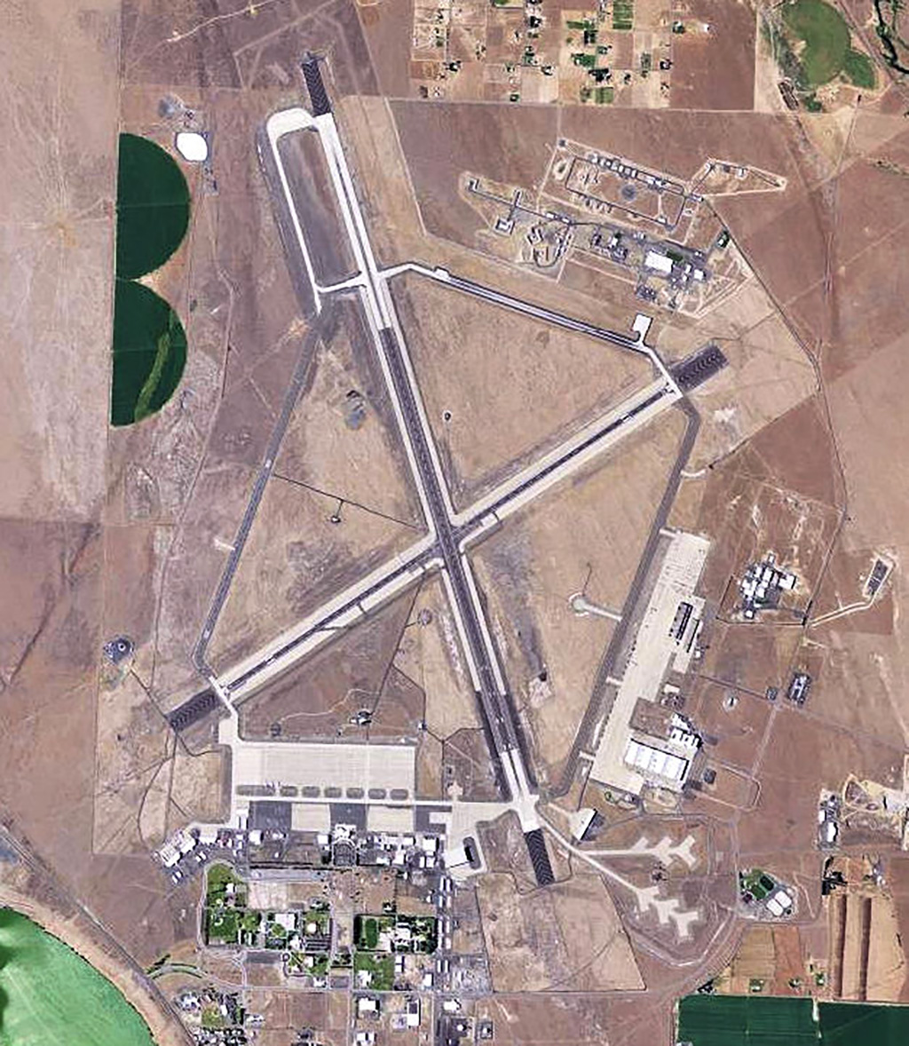
Grant County International Airport (Port of Moses Lake): Home to one of the largest airports in the United States, with a monstrous 13,503-foot main runway designated an alternative landing site for NASA's Space Shuttle. Opened in 1942 as the Moses Lake Army Air Force Base, used for pilot training, and renamed Larson Air Force Base. Used for military testing and training purposes and housed a Titan missile base until 1965. Airport and related industrial facilities transferred to Port of Moses Lake in 1966, and is used for civilian aircraft testing and pilot training. The facility now sprawls over nearly 4,700 acres. A port-owned industrial park is located adjacent to the airport.
- Primary uses: General aviation, military, firefighting, charter, jet testing and training
- Total annual air passengers (2009): 1,637
- Total active runways: 5
- Longest runway: 13,503 feet
- Passenger carrier airlines providing scheduled service: none since June 2010. This may lead to a change of classification.
Seattle-Tacoma International Airport (Port of Seattle): By far the dominant airport in Washington state, the airport bears the name of Tacoma in recognition of an early financial contribution $100,000 by the City and Ports of Tacoma and by Pierce County. Construction began in 1942, spurred by a need to replace other civilian airports that had been converted to military use. Initial financing included a $1 million grant from the federal Civil Aviation Authority, but total costs upon completion were $4,235,000. The airport hosted its first commercial landing on October 31, 1944, but was used for mostly military purposes until war's end.
- Primary uses: Commercial passenger, air cargo, general aviation
- Total air passengers (2009): 31,227,512 (85,555 per day average)
- Arrivals and departures 2009: 317,873 (871 per day average)
- Total cargo (metric tons) 2009: 269,689
- Total active runways: 3
- Longest runway: 11,901 feet
- Passenger carrier airlines providing scheduled service 2009: 29
Tri-Cities Airport (Port of Pasco): Located in Franklin County in southeast Washington. Started as Pasco Airport, moved and renamed Franklin County Airport in 1930s. Became Pasco Naval Air Station during World War II; at war's end transferred to city of Pasco. Ownership assumed by Port of Pasco in 1963, which undertook and completed substantial improvements.
- Primary uses: Commercial passenger, air cargo, firefighting, general aviation
- Total annual air passengers: 250,000 (2007)
- Number of active runways: 3
- Longest runway: 7,700 feet
- Passenger carrier airlines providing scheduled service: 4 (2007)
Bellingham International Airport (Port of Bellingham): Started in 1936 by Whatcom County using New Deal funds. First runway was called "Road to Nowhere" because it was covertly paved using money earmarked for highway development. Army Corps of Engineers built two additional runways in 1941, which ironically were dedicated on December 7, the very day Pearl Harbor was attacked. Used as an Army Air Force Base called Tulip Field during the war, then operated by a commission until 1957 when it was sold to the Port of Bellingham for $1. The original passenger terminal, designed by noted architect F. Stanley Piper in the 1940s, was replaced by the Port in 1980 with a new $1 million facility.
- Primary uses: Commercial passenger, charter, medical transport, law enforcement
- Total annual air passengers 2009: 200,000+
- Number of active runways: 1
- Longest runway: 6,701 feet
- Passenger carrier airlines providing scheduled service: 4 (2010)
Walla Walla Regional Airport (Port of Walla Walla): U.S Army took over Walla Walla Municipal Airport in during World War II and developed the 2,100-acre Walla Walla Army Air Base. Declared surplus in 1947 and given over to city and county of Walla Walla, which ran it until 1989. Port of Walla Walla took over and renamed the facility Walla Walla Regional Airport. Complex now covers 2,400 acres and includes an industrial park.
- Primary uses: Commercial passenger, Civil Air Patrol, firefighting, law enforcement, medical, agricultural, general aviation
- Total annual air passengers 2009: 33,430
- Number of active runways: 3
- Longest runway: 6,526 feet
- Passenger carrier airlines providing scheduled service: 1 (2010)
Pangborn Memorial Airport (Port of Douglas County and Port of Chelan County): The only airport jointly operated by port authorities from two different counties. Opened in 1941 by the city of Wenatchee and named after Clyde Pangborn, who in 1931 landed in East Wenatchee after completing the first non-stop, trans-Pacific airplane flight. Transferred to the Port of Chelan in 1965. In 1974, Chelan deeded a one-half interest in the airport to the neighboring Port of Douglas County, which operates the airport's business park and non-aviation operations. Together the Ports have steadily improved the facility, opening a new terminal building in 1992 and completing an instrument-landing system in 2006.
- Primary uses: Commercial passenger, air cargo, emergency services, general aviation
- Total annual air passengers: 49,456 (2009)
- Number of active runways: 2
- Longest runway: 5,500 feet
- Passenger carrier airlines providing scheduled service: 1 (2010)
William R. Fairchild International Airport (Port of Port Angeles): One of two airports owned and operated by the Port of Port Angeles in Clallam County (Sekiu Airport is the other). Developed the 1930s with WPA funds as a civilian airport, taken over and used by the Army, the Navy, and, in 1942 and 1943, the Coast Guard. Transferred from the Navy to Clallam County in 1948 and named Clallam County Municipal Landing Field. Ownership was assumed by the Port of Port Angeles in 1951. William Fairchild started Angeles Flying Service there in 1953 and became the first airport supervisor. The airport was named in his honor in 1969 following his death in an airplane crash.
- Primary uses: Commercial passenger, air cargo, emergency services, general aviation
- Total annual air passengers: 13,243 (2009)
- Number of active runways: 2
- Longest runway: 6,347 feet
- Passenger carrier airlines providing scheduled service: 1 (2010)
Friday Harbor Airport (Port of Friday Harbor): Had its beginning in 1948 when local charter pilot Roy Franklin used a cow pasture on the island for takeoffs and landings. The voters of the county established a port district in 1950, and it now owns and operates the popular airfield. It is one of three airports serving the region, together with those on Orcas and Lopez islands.
- Primary uses: Commercial passenger, general aviation, medical evacuation, aerial tours, charter
- Total annual air passengers: 13,413 (2009)
- Number of active runways: 1
- Longest runway: 3,400 feet
- Passenger carrier airlines providing scheduled service: 2 (2010)
Anacortes Airport (Port of Anacortes): One of the few port-owned airfields that has never been anything else, and one of two port-owned airports in Skagit County (the other is Skagit Regional, owned by the Port of Skagit County). Port of Anacortes purchased land and started construction in 1968, using FAA grant money. Opened to first air traffic in November 1969. By 2005 the port commission was dominated by members who favored closing the airport, but an election that year replaced them with airport supporters, saving the facility.
- Primary uses: Commercial passenger, charter, aerial tours, general aviation
- Total annual air passengers: 1,229 (2009)
- Number of active runways: 1
- Longest runway: 3,015 feet
- Passenger carrier airlines providing scheduled service: 1 (2010)
Orcas Island Airport (Port of Orcas): The Port of Orcas Island is one of only two port districts in the state that were formed solely to operate an airfield (the other is the Port of Lopez Island). Port of Orcas was formed in 1958, floated a $20,000 bond issue, and purchased an existing airstrip from a local family.
- Primary uses: Commercial passenger, general aviation, medical evacuation, charter
- Total annual air passengers: approx. 5,000 (2006)
- Number of active runways: 1
- Longest runway: 2,900 feet
- Passenger carrier airlines providing scheduled service: 2 (2010)
Regional Service Airports
Regional Service Airports serve large or multiple communities, have at least 40 based aircraft and a minimum 4,000-foot long runway, or are used as overflow reliever airports under the FAA' s National Plan on Integrated Airport Systems. Of the 19 regional service airports in Washington state, six are port-owned and operated. They are:
Bremerton National Airport (Port of Bremerton): Started by Kitsap County in 1939 and used throughout World War II for military purposes. County resumed operating the field as Kitsap County Airport after the war; deeded 1200 acres, including the airport property, to Port of Bremerton in 1963. In 1983 the Port renamed the facility Bremerton National Airport. Currently the largest airport on the Kitsap Peninsula. Port also operates the Olympic View Business and Industrial parks on property adjacent to the airport.
- Primary uses: Air-taxi operations, general aviation, flying club, Civil Air Patrol
- Number of based aircraft: 191 approx. (2007)
- Number of active runways: 1
- Runway length: 6,200 feet
Skagit Regional Airport (Port of Skagit County): One of two port-run airports in Skagit County (the other is Anacortes Airport, owned by the Port of Anacortes). Originally a New Deal project, the first runway was built in 1933 just west of Burlington. Used by U.S. Navy in World War II and operated by federal government until 1958. Transferred to Skagit County that year, then deeded to Port of Skagit and Port of Anacortes as joint owners in 1968. Port of Skagit took full ownership in 1975 and has operated the airport since.
- Primary uses: Charter, Civil Air Patrol, general aviation, some military use
- Number of based aircraft: 150 approx. (2009)
- Number of active runways: 2
- Longest runway: 5,477 feet
Olympia Regional Airport (Port of Olympia): Origins unclear, but civil aviation at what is now Olympia Regional Airport dates back to the 1920s. Used as an Army Air Force Base during World War II, reverted to civilian control after the war. Port of Olympia took over in 1963. Airport is also the site of the Olympic Flight Museum.
- Primary uses: Civil Air Patrol, firefighting, medical, law enforcement, tours
- Number of based aircraft: 177 approx. (2008)
- Number of active runways: 2
- Longest runway: 5,419 feet
Sanderson Field (Port of Shelton): Named after Lieutenant Lawson Sanderson who selected the site in 1927. Used as naval auxiliary air station from 1943 until December 1945. Operated for several years post-war as Mason County Airport. Deeded to the Port of Shelton in 1957 by the General Services Administration. Sanderson name was restored in 1966. Port also operates the Airport Industrial Park on the site. The airport currently (2010) is operated under a joint use agreement with the military and is frequently used by military aircraft.
- Primary uses: Flying club, charter service, general aviation, significant military use
- Number of based aircraft: 102 (2007)
- Number of active runways: 1
- Longest runway: 5,005 feet
Bowerman Field (Port of Grays Harbor): Originally called Moon Island Airport. Established some time prior to World War II, developed by the army as an Out Lying Field in 1942, and returned to civilian control in 1946. Renamed in honor of World War II fighter pilot Robert Bowerman in 1953. Operated for several years by Grays Harbor County, with financial contributions from Port of Grays Harbor, which took over sole ownership and control in 1962. Port has made substantial improvements in years since, including installation of an instrument landing system. Currently (2010) Bowerman is Washington's only jet-capable coastal airport.
- Primary uses: General aviation, flying club, some military
- Number of based aircraft: 25 (2007)
- Number of active runways: 1
- Longest runway: 5,000 feet
Grand Coulee Dam Airport (Port of Grant County Dist. NR 7): There is little readily available information on the origins of Grand Coulee Dam Airport, one of four port-run airports in Grant County (the others are owned and operated by the Port of Ephrata, the Port of Quincy, and the Port of Moses Lake). The airport is about two miles from the small town of Electric City, which was incorporated in 1950.
- Primary uses: General aviation, medical transport
- Number of based aircraft: 7 (2009)
- Number of active runways: 1
- Longest runway: 4,200 feet
Community Service Airports
Community Service Airports serve a community and have at least 20 based aircraft and a paved runway. Of the 22 community service airports in the state, 10 are port-owned and operated by port districts. They are:
Ephrata Municipal Airport (Port of Ephrata): One of five port-run airports in Grant County (the others are Grand Coulee, Grant County International, Quincy Municipal, and Wilson Creek). Opened as part of the Ephrata Army Base in 1942; used to train heavy-bomber pilots and fighter pilots. Turned over to civilian control after the war. Port district was established in 1965. Airport includes a Port-owned onsite industrial part and a runway dedicated to glider use.
- Primary uses: General aviation, glider flights, Civil Air Patrol, law enforcement, medical transport
- Number of based aircraft: 17 powered, 50 gliders (2005)
- Number of active runways: 3
- Longest runway: 5,500 feet
Othello Municipal Airport (Port of Othello): Initially owned and operated by City of Othello. Port district established in 1966 and operates airport and airport-based industrial park.
- Primary uses: General aviation, medical transport, agricultural spraying
- Number of based aircraft: 10 (2005)
- Number of active runways: 1
- Longest runway: 3,564 feet
Richland Airport (Port of Benton ): One of two airports operated by the Port of Benton (the other is Prosser Airport) and one of three port-operated airports in Benton County (the third is operated by the Port of Kennewick).
- Primary uses: General aviation, flying club, Civil Air Patrol, firefighting, medical transport, agriculture
- Number of based aircraft: approx. 173 (2007)
- Number of active runways: 2
- Longest runway: 4,009 feet
Vista Field (Port of Kennewick): One of three port-owned airports in Benton County (the other two are operated by the Port of Benton). Opened in 1942 as the Kennewick municipal airport, taken over by the Navy during World War II, returned to city ownership at war's end, and sold to the Port of Kennewick in 1991. Despite public pressure to close the airport and convert the land to business development, port commissioners voted in 2010 to continue airport operations.
- Primary uses: General aviation, law enforcement, firefighting, flying club, Civil Air Patrol
- Number of based aircraft: 35 (2007)
- Number of active runways: 1
- Longest runway: 4,008 feet
Prosser Airport (Port of Benton): One of two airports operated by the Port of Benton (the other is Richland Airport) and one of three port-operated airports in Benton County (the third is operated by the Port of Kennewick).
- Primary uses: General aviation, agriculture
- Number of based aircraft: 53 (2007)
- Number of active runways: 1
- Longest runway: 3,450 feet
Lake Chelan Airport (City of Chelan/Port of Chelan): One of two Port of Chelan shared airports (the other is Pangborn Memorial, located in Douglas County and shared with the Port of Douglas County). Originally a rugged airstrip dating back to 1930; evolved over the years into facility serving primarily recreational aircraft in the resort community. Jointly funded by City and Port.
- Primary uses: General aviation, flying club, agriculture service, medical transport
- Number of based aircraft: approx. 69 (2010)
- Number of active runways: 1
- Longest runway: 3,503 feet
Port of Whitman Business Air Center (Port of Whitman County): The Port operates a small, general-aviation airport and business park four miles from the county seat at Colfax.
- Primary uses: General aviation, agricultural, medical transport
- Number of based aircraft: approx. 18 (2005)
- Number of active runways: 1
- Longest runway: 3,209 feet
Jefferson County International Airport (Port of Port Townsend): International port of entry. Originally a small Army Air Force field built shortly before World War II. Port took over in 1959. Concrete runway built in 1990 and on-site industrial park is being developed (2010). In 1990, the original grass landing strip was replaced with a 3,000-foot concrete runway. Home to Port Townsend Aero Museum.
- Primary uses: General aviation, charter, medical transport
- Number of based aircraft: 106 (2009)
- Number of active runways: 1
- Longest runway: 3,001 feet
Lopez Island Airport (Port of Lopez): The Port of Lopez Island is one of only two port districts in the state that were formed solely to operate an airfield (the other is the Port of Orcas Island). Port district established and airport built in 1978.
- Primary uses: General aviation, air taxi
- Number of based aircraft: 42 (2007)
- Number of active runways: 1
- Longest runway: 2,904 feet
Grove Field (Port of Camas-Washougal): Founded by Camas aviator Ward Grove in 1946 and transferred to joint Port of Camas/Washougal in 1962, which paved the runway in 1990. Airport covers 106.64 acres and has 79 hangars.
- Primary uses: General aviation, flying club, firefighting, medical transport
- Number of based aircraft: 71 (2008)
- Number of active runways: 1
- Longest runway: 2,710 feet
Local Service Airports
Local Service Airports serve a community, have fewer than 20 based aircraft, and have a paved runway. Of 33 total local service airports in Washington state, five are owned and operated by port districts and two are on land leased by a port district from another governmental unit.
Willapa Harbor Airport (Port of Willapa Harbor): One of two port-owned airports in Pacific County (the other is owned by the Port of Ilwaco). Opened by the Port in 1949 behind dikes on the flat bottomland of the Willapa River valley northwest of South Bend. During World War II the military had started developing an airstrip at the site, but it was not completed until the Port took over after war's end.
- Primary uses: General aviation, flying club
- Number of based aircraft: 4 (2007)
- Number of active runways: 1
- Longest runway: 3,000 feet
Sekiu Airport (Port of Port Angeles): One of two airports owned and operated by the Port (the other is Fairchild International). Located in western Clallam County at the small town of Sekiu.
- Primary uses: General aviation, Civil Air Patrol, medical transport, some military
- Number of based aircraft: not available
- Number of active runways: 1
- Longest runway: 2,997 feet
Waterville Municipal Airport (Port of Douglas County): One of three airports owned by Port of Douglas County (the others are Mansfield and Pangborn). First used as a landing area in 1924, the airport was owned by the town of Waterville until 1996, then transferred to Port of Douglas County. Located on 35.34 acres of lane one-half mile adjacent to the town's northeast boundary, was first used as a landing area in 1924. All structures on airport property are privately owned.
- Primary uses: General aviation, agriculture, Civil Air Patrol, law enforcement
- Number of based aircraft: 13 (2005)
- Number of active runways: 1
- Longest runway: 2,978 feet
Mansfield Municipal Airport (Port of Douglas County): One of three airports owned by Port of Douglas County (the others are Waterville and Pangborn). Located just two blocks from downtown Mansfield on approximately 22.8 acres of land.
- Primary uses: General aviation, agricultural, flying club
- Number of based aircraft: not available
- Number of active runways: 1
- Longest runway: 2,575 feet
Ilwaco Airport (Port of Ilwaco): One of two port-owned airports in Pacific County (the other is owned by the Port of Willapa). Airport established in 1971 on 34 acres east of the town of Ilwaco. Has shortest runway of all port-owned airfields.
- Primary uses: General aviation
- Number of based aircraft: not available
- Number of active runways: 1
- Longest runway: 2,070 feet
Quincy Municipal Airport (Port of Quincy): Port operated, but built in 1979 on land owned by the city of Quincy and leased by the port for $1 per year. Runway was reconstructed in 2004.
- Primary uses: General aviation, medical transport
- Number of based aircraft: 6 (2009)
- Number of active runways: 1
- Longest runway: 3,660
Wilson Creek Airport (Grant County Port District No. 6)
Operated by Grant County Port District #6 and leased from the Town of Wilson Creek since 1988. The airport's 120 acres are primarily within the town's corporate boundaries. Most of the land is owned by the town, with smaller parcels owned by the port district and a private party. The airport is currently used by local pilots, the Big Bend Community College Flight program, Jackson Flight Center, agricultural-support planes, and ultra-lite pilots.
- Primary uses: general aviation, agricultural
- Number of based aircraft: 1 (2011)
- Number of active runways: 1
- Longest runway: 3,074
In addition to 33 land-based airports, there are two port-owned seaplane bases in Washington, one operated by the Port of Friday Harbor and the other by the Port of Poulsbo.
