On August 29, 1961, voters on Whidbey Island approve the formation of the Langley Port District to develop an all-season boat marina in the town of Langley. This original port district, which consists of the town and portions of the rural precincts of Sandy Point, Saratoga, and Useless Bay, has an insufficient tax base to finance the marina, and in November 1968 another public vote greatly enlarges the district's boundaries to include most of the southern one-third of Whidbey Island. But even the expanded district proves unable to afford the planned 400-slip marina, and in 1979 the Port, the City of Langley, and the state join forces to build a much smaller facility, which the City will operate for the next 20 years. The Port, meanwhile, will go on to develop other public facilities within its district. In January 2009, Langley will transfer ownership of the marina to the port district. Hampered by the world economic downturn and voter rejection of a 2008 funding measure, the Port is forced to greatly scale back its plans for marina development and will concentrate instead on the management and incremental improvement of all its facilities.
A Very Big Island
At approximately 230 square miles, Whidbey Island is the one of the largest islands in the contiguous United States. It is named after Joseph Whidbey (1757-1833), master of H. M. S. Discovery, one of the ships under the overall command of the British explorer, Captain George Vancouver (1758-1798). Whidbey circumnavigated the island in 1792, sailing through Deception Pass and establishing that the long and narrow land mass was in fact an island, and not part of the mainland as early Spanish maps had claimed. Occupied for centuries by coastal divisions of the Salishan linguistic group of Indians, sometimes called the "Whidbey Island Skagits," the island didn't see its first permanent non-Native presence until 1850, when Captain Isaac Ebey (1818-1857) claimed land on the western side of the island not far from present-day Coupeville.
Whidbey Island is naturally divided into three roughly equal sections by two long inlets, Penn Cove and Holmes Harbor, and the area known as South Whidbey lies primarily south and east of the latter. The Port of South Whidbey is coextensive with South Whidbey School District No. 206, encompasses 41,182 acres (64.35 square miles), and is divided into three commissioner districts, known as Freeland, Langley, and Clinton, after three island communities. Of the three, only Langley is incorporated as a city under state law.
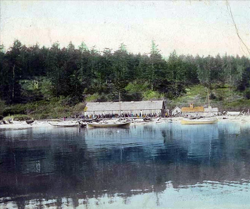
Langley, which hugs the water along Saratoga Passage and calls itself "The Village by the Sea," was incorporated in 1913, although its roots go back to as early as 1890, when settler Jacob Anthes (1865?-1939) bought the tract of land that would later become the town. Anthes quickly convinced a group of businessmen to form the Langley Land and Improvement Company, named after one of its members, Judge J. W. Langley of Seattle. The company recorded the initial Langley plat in 1891, then built the town's first dock, which attracted steamers plying the waters of Puget Sound. Langley was an active, working port, handling mostly agricultural products and lumber and serving as a ferry landing for passenger traffic to and from the mainland.
The financial Panic of 1893 slowed the region's economy, and a storm in 1894 destroyed Langley's dock. In 1902, the Langley Land and Improvement Company deeded all the property back to Jacob Anthes in return for $3,000, and he built a new dock, once again drawing freight and passenger traffic to the small town. Finally, in 1912, a group of local citizens banded together and filed to incorporate Langley, a status that was granted the following year.
The Port of Langley
The Port of South Whidbey Island had its beginnings as the Port of Langley, a municipal corporation approved by the voters in 1961. That first district was composed of the town of Langley itself and portions of the rural precincts of Sandy Point, Saratoga, and Useless Bay. The coming of regular vehicle-carrying ferries and the rise of the trucking industry had long before robbed Langley of its value as a working port, and it was hoped that the new port district could develop a 400-slip marina on the Langley waterfront that would serve all of South Whidbey Island.
Beginning in 1965, the Port began preparations for a 6.8 acre marina and harbor facility at the base of Anthes Street in Langley. Conceptual plans were drawn, and the Port secured a tentative commitment from the Army Corps of Engineers for dredging and breakwater work. But financial realities intervened before the idea could be taken much further. The ability to redeem bonds that were to be sold to help finance the project would require 80-percent occupancy at the completed marina, which the Port could not guarantee. That, in combination with a population that was too small to provide a broad tax base from which significant funding could be drawn, led to a decision to put the plan aside, at least for the time being.
The Port of Langley then decided to focus on increasing its size, which would increase its ability to fund projects through property-tax levies. This took time, and it was not until November 5, 1968, that the voters of South Whidbey approved the Port's expansion to its present boundaries by a narrow margin of 787 to 702. Although it now covered a much greater areas, the port retained the "Langley" name for over 10 years, officially becoming the "Port of South Whidbey Island" only in 1979.
Growing Pains
Perhaps due to recent changes in the law, the ballot measure put to the voters in 1968 was not as artfully worded as it might have been. Although the election increased the size of the port district many times over, it failed to formally establish commissioner districts for the added areas, nor did it offer candidates for commissioners to represent those who lived those areas. A majority of the people who were now included within the Port's boundaries were left with no voice on the port commission, and this of course brought the legality of the entire Port into question.
This was not the only problem. One seat on the Port of Langley commission was up for election in 1969, but a resignation from the commission created another vacancy. This meant that two of the three commission positions would be unfilled. The prospect of a huge majority of the district's residents being unrepresented on a commission with two empty seats was unthinkable, and the Port turned to the Supervisor of Elections in the office of the Washington State Secretary of State for advice, which was forthcoming. The confusion was eventually cleared up, and the Port of South Whidbey Island has ever since been composed of three districts, which are identified as Freeland (District 1), Langley (District 2), and Clinton (District 3).
The enlarged port district now encompassed over 64 square miles with 53 miles of saltwater shoreline. Under its umbrella were one incorporated town, Langley; three smaller commercial areas, Clinton, Freeland, and Bayview; and thousands of acres of forest and residential land. After a difficult start, it was time to move on.
Working Well with Others
With the Port now on a sound legal foundation, hopes of reviving the Langley marina project were rekindled, only to be extinguished again. First, the passage of the state's Shorelines Management Act in the early 1970s made it unlikely that the Port would be able to obtain the necessary dredging and construction permits. Then the Army Corps of Engineers withdrew its financial support. The projected costs also gave rise to substantial local opposition, and the proposed marina in its original form was abandoned in 1975. The Port went on to other matters, concentrating its efforts on facilitating public access to the district's shorelines through the establishment of boat-launching ramps and parks. But the idea of a marina in Langley never went away, and for decades to come it was to engender both cooperation and conflict between the Port and other interested parties.
In 1975, the same year the Port put aside its original concept for a marina, Langley upgraded its legal status and became a code city under state law. Coincidentally or not, it wasn't long before the idea of a City-owned marina resurfaced, and Langley began looking to other governmental bodies for planning and funding assistance. In 1979, the Port of South Whidbey joined with the City of Langley and the state's Interagency Committee for Outdoor Recreation to develop a transient-moorage marina to be called the Langley Boat Harbor. The facility, which could accommodate approximately 40 small vessels, consisted of floating, concrete finger piers anchored to treated timber pilings, all protected by a floating tire breakwater. The Port initially contributed $110,000 to the project, and $240,000 was provided by the interagency committee.
In cooperation with other governmental units, the Port continued to support the boat harbor, tossing another $10,000 into the pot for additional marina work in 1985. Then, in 1986, the tire breakwater sank, and the Port contributed $30,000 toward replacing the breakwater and upgrading the facility, work completed in 1988. The Port also owned one-half of the property on which the marina's boat-launching ramp was located.
With the original marina plan now set aside, the Port again turned its attention and resources to providing greater public access to the water by developing boat ramps, waterside parks, and other recreational facilities on South Whidbey. Faced with limited resources, it had to rely on cooperation with other agencies and governmental units to accomplish its goals. Since its enlargement in 1968, the Port of South Whidbey has partnered with, among others, Island County, the City of Langley, the Port of Coupeville, the State Interagency Committee for Outdoor Recreation (now known as the Recreation and Conservation Funding Board), the Washington State Department of Transportation, Washington State Ferries, the state departments of Fish and Wildlife and Natural Resources, and the U.S. National Parks Service.
Since the early 1980s, the Port, often in concert with Island County, with which it has an interlocal agreement, has developed the following public facilities:
- Bush Point Boat Ramp, a four-acre site located on the southwest coast of the island, provides parking, restrooms, beach access, and fishing facilities, in addition to its boat-launching ramp. The ramp is supplemented with floating docks in the spring. The Port, in partnership with the state Department of Fish and Wildlife and the Recreation Conservation and Funding Board, purchased the ramp from private owners in 2000.
- The Mutiny Bay Facility, just a few miles south of the Bush Point facility, is owned by the Port in partnership with Island County. It features a boat launching ramp, fishing, parking, and access to the beach. The County is responsible for day-to-day operations and maintenance.
- The Freeland Park and Holmes Harbor Boat Ramp Facility, located at the southern end of Holmes Harbor, is also owned in partnership with Island County and offers a boat launch, accessible parking and restrooms, sheltered picnic area, children's swings and play equipment, and fishing and beach access. The Port maintains the launch ramps and other waterside features, and the County takes care of the upland facilities.
- Possession Beach Waterfront Park Facility offers a small park and a boat launching ramp at Possession Beach on the southeast corner of Whidbey Island. The waterfront portion of the park, which is about 1/3 of the total area, contains picnic areas, interpretive stations, parking, and utilities, along with a residence occupied by the Port's on-site manager. There is a wetlands between the sandy shoreline and a 14-acre, port-owned hillside tract that is scaled by the Dorothy Cleveland Trail. (Port plans to sell this upland property triggered considerable controversy in 2010 and 2011).
- Clinton Beach Park, completed in 2006, provides public access to the seashore on the east side of Whidbey Island, adjacent to the landing dock of the Mukilteo-Clinton ferry. Built at a total cost of more than $500,000, the park offers picnic areas and a community pier, a temporary mooring dock, parking, beach access, accessible restrooms, and storage facilities for bicycles and kayaks. In the year of its dedication, Clinton Beach Park received the Glen Hunt Award, which honors "the seamless integration between architecture and landscape," from the Northwest Washington Chapter of the American Institute of Architects ("Aware Descriptions," AIA website).
- Dave Mackie Park, a five-acre site located at the southern end of the eastern shore of Useless Bay, is owned in partnership with Island County, and the County has the day-to-day responsibility for its operation. It has a public boat launch, accessible parking and restrooms, a sheltered picnic area, children's swings and play equipment, fishing and beach access, and a ball field.
- Humphrie Road Parking Lot, located near the Whidbey Island ferry terminal, has been owned by the Port since the 1990s, and generates fees for the Port by accommodating vehicles whose owners board the ferry as foot passengers.
In 1985, the Port conducted a study of converting the private Whidbey Airpark (Porter Field) into a Port-run public facility. The idea was abandoned in the early 1990s after it was determined to be not feasible. In another significant action, the port commission in 1990 adopted a resolution detailing the Port's commitment to protecting the air and water quality of its district from such environmental hazards as toxic or hazardous substances, and in 1992 the resolution was expanded to establish noise standards as well.
The South Whidbey Harbor and Phil Simon Park
Throughout the Port's existence, attempts to create a substantial marina on the Langley waterfront have caused both conflict and cooperation. In 2003 the City and the Port agreed to work together to develop plans for expanding and improving the facility. They joined forces to prepare a "Langley Boat Harbor and Environs Master Plan," an ambitious blueprint for future development that was released to the public on April 26, 2004. After considering different options, the study recommended that the marina be expanded to 200 mooring slips, ranging in size from 20 feet to more than 60 feet. The plan included the addition of a fuel dock, a small-boat center, improved launching facilities, a dock for seaplanes, and significant upland improvements.
Then things started to unravel. The Port and the City had tentatively agreed that the marina property would be turned over to the Port by January 2006, but at a meeting held on March 2, 2005, it became clear that there was no agreement on just how much property should be transferred, when it should occur, and who should be responsible for what. Complicating the issue was a growing belief among several members of the city council that Langley should retain ownership of the marina, or at least significant parts of the upland property. There was no disagreement that the marina was in dire need of improvement, but almost every other issue implicated in the proposed land transfer was unresolved, and the City appeared to be getting cold feet.
The port commissioners and Langley officials met again one week later, on March 9, and the contentious nature of the meeting indicated that their differences could not be bridged. At the end of the meeting, the port commission voted 2-1 to pull out of the pact to take over the boat harbor and to help pay for future improvements. This seemed to mark a disappointing end to what had looked like a promising union.
All was not lost, however. The port commission and Langley officials met in August 2005 and again in December to try work things out. This led to further consultations, and in April 2007 the City and the Port entered into a formal, interlocal agreement that would transfer the marina property to the Port. It would take nearly two years for all the legal details to be hammered out, but the transfer was finally formalized on March 2, 2009. Langley Mayor Paul Samuelson and Port of South Whidbey commissioners Lynae Slinden, Geoff Tapert, and Rolf Seitle met to sign the final papers at the harbormaster's office, and the Port of South Whidbey Island took over ownership of what would now be called the South Whidbey Boat Harbor, and the adjacent Phil Simon Park. Commissioner Seitle took note of the transaction's somewhat tortured history:
"We started all this in 2003 and the process certainly has had its ups and downs. All of us agree it was the right thing to do for Langley and the people of South Whidbey" ("Port, City of Langley Finalize Transfer of City Marina," South Whidbey Record).
It proved unfortunate that the agreement was delayed until the country and the world were in the grip of a major economic downturn. After the interlocal agreement with the City was signed, the Port had placed an $8.2 million marina bond issue before the voters in November 2008, only to see it defeated by a margin of more than 2 to 1. The taxpayers were in no mood to finance anything, and the Port had no option but to drastically dial back its plans.
Living with Less
Using the ambitious 2004 Master Plan as a starting point, the Port in 2009 began a process of prioritizing the much-needed work at the South Whidbey Boat Harbor. In consultation with the City of Langley, other public agencies, and the public, the Port came up with a new plan that would break the project down into at least two phases. In Phase I-A, which is still in the permitting process (February 2011), the Port plans to remove the old Hein dock at the boat harbor, along with a substantial number of creosote pilings, and install two new breakwaters with a connecting causeway. What had started as a $12-million project was whittled back to approximately $4 million. Island County has committed $1.2 million for the work, and the Port is hoping to obtain an additional $2.9 million from the U.S. Fish and Wildlife Service and the Coast Guard. This would give it enough funding the finally get started on the long-delayed project.
Another money-raising measure recently taken by the Port has been more controversial. In August 2010 the port commission began studying the possible sale of the property upland from its Possession Beach facility, where the Dorothy Cleveland Trail is located, reportedly to facilitate the installation of a cell-phone tower. At a meeting on October 20, 2010, the port commission voted unanimously to amend the 2007-2010 Comprehensive Scheme by deleting plans to improve the trail. This was a clear signal that the commissioners intended to forge ahead, and it wasn't long before it officially declared the land to be "surplus," and thus available for sale.
The Port justified the sale on the grounds that economic development and the improvement of its existing waterside properties should be where its resources were directed, rather than spending money on the maintenance of upland parks. Many of its constituents agreed, but many others were angered by the proposal, and made their anger known at subsequent meetings of the port commission. Notwithstanding a wide split in public opinion, the land was put on the market in February 2011, with an asking price of $235,000. The Port has said that it will give extra consideration to any potential purchaser who agrees to preserve the trail, but this has not mollified those opposed to the sale.
In its six-year Comprehensive Scheme, issued in 2007, the Port established three overarching goals -- economic development, environmental stewardship, and marine access and recreation. With the extraordinary economic challenges that started just one year later, the commission has concentrated its efforts on the first goal, while not losing sight of the other two. There is confidence that once economic conditions improve, the Port will be able to complete long-deferred projects and make even greater contributions to the economic, environmental, and recreational well-being of its island constituents.
