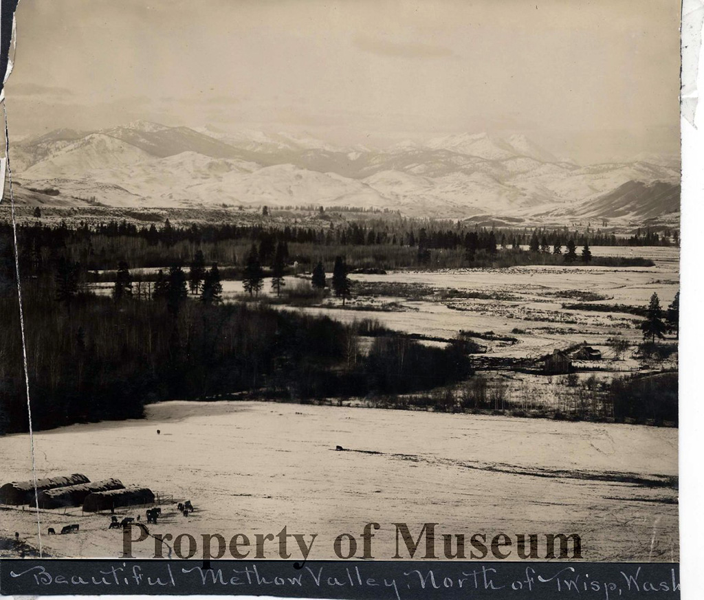
Twisp, a small town in Okanogan County in north central Washington, sits at the confluence of the Twisp and Methow rivers in the eastern foothills of the North Cascade Mountains. Twisp's central location, approximately half way down the Methow Valley from the mountain headwaters to the Columbia River, helped it grow into the valley's largest town and dominant commercial center following its founding in the last decade of the 1800s. Mining, which brought the first non-Indian settlers to the valley, agriculture, and especially timber dominated the town's economy for much of its history. Twisp's timber mill is now gone. Agriculture continues to play a significant role in the town's economy, as does tourism -- significantly increased by the 1972 opening of the North Cascades Highway -- and the many small businesses serving valley residents.
Methow Indians
Researchers believe the first people to inhabit the Methow Valley arrived as many as 10,000 years ago. They initially lived year-round in pit houses -- excavated, permanent shelters with woven mats of grass or reeds for roofing. Depressions believed to be pit house foundations have been found at 18 sites in the Methow Valley. U.S. Forest Service researchers found evidence that the early inhabitants carved canoes from giant cedars that grew in the upper valley, leaving stumps of trees believed to have been about 500 years old at the time they were cut.
By the early 1800s Methow Indians were riding horses, and when the first non-Indian explorers and miners reached the Methow Valley in the mid-to-late 1800s, valley inhabitants had a more seasonal lifestyle than their ancestors. They set up large temporary camps at traditional gathering places and smaller outlying camps where they obtained and processed food and other resources. The Methow Indians were a distinct tribe that fished, hunted, and gathered food throughout the river drainage, according to historian E. Richard Hart. They fished with spears and dip nets and built weirs (fish traps) in some spots, including one just below the current site of Twisp. Summer and fall camps were occupied during hunting and gathering seasons.
"Like their neighbors, the Methows' population was severely depleted after the smallpox epidemics that began in the late 18th century. Population was said to be cut in half during the first half of the 19th century, and then depleted by half again by 1900. In 1883 there were a little over 300 Methow, which indicates that pre-contact population may have been as high as 1,200" (Hart, 11).
The Methow Valley was included in an area of land reserved by the federal government for Chief Moses and the Columbia River Indians. That original reservation extended from the Canadian border south to include Lake Chelan and from the crest of the Cascade Mountains on the west to the Columbia River on the east. However, the reservation boundaries were changed by executive orders issued in 1883 and 1886 by presidents Chester A. Arthur and Grover Cleveland. The Methow was opened to mining and non-Indian settlement in 1886.
Mining
The dream of striking gold led many an early prospector into the Methow Valley and up the tributaries of the Twisp and Methow rivers. Towns, encampments really, such as Gilbert at the headwaters of the Twisp River, and Squaw Creek up the drainage of the same name outside the later town of Methow, were born and disappeared as dreams were dashed or mines closed. There were few profitable mines in the region. However, from the seeds sown by the early miners and their families sprouted the roads, towns, and businesses that serviced the homesteaders who followed. Twisp's first entrepreneurs existed to supply prospectors. In some cases, the miners stayed and became ranchers and loggers.
The first mineral discoveries near Twisp came in the 1880s. By 1897 there were three mines listed in the Twisp Mining District -- the Alder, Crescent, and Red Shirt mines.
"The first major discovery of lode gold in the Methow Valley was on Polepick Mountain, about five miles south of Twisp... in the late 1880s. This discovery, which included silver and copper, led to the settlement of Silver ... and the nearby Red Shirt Mine ... The Red Shirt Mine produced about $100,000 in gold and silver over the years, but never enough to make a profit" (Stamper, 9, 11).
The Alder Mine was one of the most successful in the Methow Valley:
"In 1896, while panning at the mouth of Alder Creek near Twisp, T. H. Culbertson located gold. He began to work up the creek until he found the outcrop source of the metal. By the time he had staked his claims, given a combination of inferior drilling equipment and his own failing health, he was unable to develop the properties. Later owners built a large mill near the property, and the mine operated sporadically over the years. During the Second World War, the mine produced zinc, considered a critical war material. The ore was hauled by truck north to Trail, British Columbia, where zinc, copper, and a fair amount of gold was extracted. All told, about $1 million in ore was shipped from the mine" (Woodhouse et al., 192).
Mining claims and stories are woven throughout the history and families of the area. The Klinkert family, the first of whom arrived in the valley in 1897, had mining in its blood. John Klinkert Sr. had worked at various mines before settling in the Twisp River valley.
"Old John remembered the early days in the town of Twisp when seasoned old miners rode into town at a gallop, burst through the saloon doors, and shot their guns into the ceiling, all the while yelling in jubilation. At that time, goods could be paid for in gold dust, and several businesses had gold scales. A store lacking a gold scale would allow a teaspoon of the hard-earned colors as an ounce of gold" (Woodhouse et al., 227).
To this day, a number of long-time Methow Valley families retain mining claims high in the surrounding hills, but the mining boom of 1893-1894 had more or less fizzled by the turn of the century when significant numbers of families seeking homesteads started arriving.
Settlement
The origins of the Town of Twisp date to July 30, 1897, when homesteader Henry C. Glover laid out and platted a town he called Glovers-Ville. That same year a small store was established, and shortly thereafter, a post office. In 1898 Glover succeeded James Colwell as postmaster of the town, which by then was inexplicably called Twisp.
Despite persistent explanations of the meaning of the name -- that it is a Native American word for wasp or yellow jacket, or the sound made by a wasp -- the origin of the name Twisp is not known. One Okanogan County history buff suggested the town may have been named by the postal department (Wilson, 231). What is known is that Amanda P. Burgar, another early settler in the area, platted the town of Twisp on June 29, 1899, adjacent to Glovers-Ville, which thereafter was considered part of Twisp.
Whatever the origin of its name, by 1904 Twisp was considered one of the leading towns of Okanogan County. A population of miners and ranchers supported a number of local businesses. According to an unnamed early scribe whose work was published in 1904 in History of North Washington, the town had several general stores, a doctor who also owned a drug store, butcher shops, livery barns, a hotel, a boarding house with a billiard room, a blacksmith shop, two restaurants, a bank, a real estate office, a barber shop, two saloons, a state fish hatchery, an opera house, a weekly newspaper, and a Methodist church.
The unknown writer further reported that there were 75 students enrolled in schools and that the town boasted fraternal orders such as the Foresters of America and the Woodmen of the World. There was long-distance telephone service to areas outside the region and a barb-wire telephone system serving ranches and points closer to home. Daily stage service ran between Twisp and Brewster.
Methow Indians were a familiar sight to the early homesteaders and their children and grandchildren. Indian families continued to camp in their traditional spots, including on both sides of the Methow River at its confluence with the Twisp River in Twisp, in Heckendorn at the south end of present-day Winthrop, and on homesteads whose residents welcomed them and with whom they visited and traded goods. "Charlie Klinkert, who ran the salmon hatchery in Twisp in 1898, once counted 200 tepees at an encampment near the hatchery..." (Bound for..., 50).
About 1903, James Holcomb, a butter maker from Ellensburg, started the first creamery in Twisp. It was taken over by a local man who expanded the operation. Thus began a dairy industry that helped many a local family who kept a small herd of dairy cows. Such farmers brought their cream to town once a week and sold it to butter makers in Twisp and Winthrop, gaining income that helped make the monthly payments due on their land. The butter was hauled overland twice a week to the steamboat landing in Brewster for distribution to points along the Columbia River and in Seattle. The Winthrop Creamery's 1913 report to the government stated that 85,000 pounds of butter were produced during the fiscal year.
Twisp continued to thrive. The town was incorporated on August 6, 1909, and elected its first officers. The main issues to come before the five-member town council were stock running loose, liquor licenses for saloons, curfews, and peddlers. By the 1910 census there were 227 citizens counted as Twisp residents.
Twisp had two saloons in the summer of 1910 when local-option elections were held in Washington to determine whether towns would embrace Prohibition, which had been rejected in 1889 at the state level. Both saloons served free drinks all day and into the evening on election day. The Riverside Argus quoted a witness who said that all 88 qualified voters had attended one or both open houses that day, yet the vote was 56 wet, 32 dry. There was no explanation of why 32 people partook of the saloon keepers' generosity but voted against the sale of alcohol.
Electricity and the valley's first movie house came to Twisp in 1911.
Railroad Dreams
The closest a railroad track ever came to the Methow Valley was Pateros, located where the Methow flows into the Columbia, which the Great Northern Railway's track reached in 1913. But for decades there were those who dreamed of the day when rail service would come up the valley and boxes of apples would be shipped out.
A rail line was proposed over the North Cascade Mountains from the Bellingham Bay & British Columbia Railroad in the early 1900s. Nothing came of it.
In 1910, T. W. Graham, a traveling freight agent for the Great Northern, traveled to the Methow and reported seeing numerous irrigation ditches, thousands of apple trees, copper and gold mining, and billions of board feet of timber -- all of which sparked him to recommend building a branch line from Pateros to Early Winters. Graham "predicted the Methow eventually would produce as many apples as the Wenatchee Valley, enough to load 10,000 cars annually" (Wilson, 284). But his recommendation also went nowhere.
Six years later there was another attempt -- this time to bring a spur line to Twisp and Winthrop from the Great Northern line at Pateros. Incorporation papers were filed for the Methow Valley & Eastern Railway. "On May 12, 1917, S.S. Callahan, a Twisp promoter, announced that Erickson Bros. of Krupp, Wash., had signed a contract to build the line within a year. It came as no surprise to anyone that not a tie was ever laid" (Wilson, 284)
Fire
Like most early settlements in Washington, the town of Twisp was largely built of wood. And like many others, it was the victim of a devastating fire. Shortly after midnight on July 24, 1924, fire broke out at the home/office of Dr. Holmes in downtown Twisp. The doctor and his wife were awakened by the heat and managed to grab their two children before escaping. There were no fatalities. However, a light breeze pushed the blaze, and in one-and-a-half hours it consumed two houses and 23 buildings in the downtown business district. Only the Filer and McAlister grocery store and the Commercial Bank's vault survived within the fire zone. Both were built of red brick.
Marie Filer Risley, who lived just north of town, recalled waking up in the wee hours to the sound of the fire bell and an orange glow over downtown Twisp. Her husband, Leonard, ran to town while she stayed home with their baby. "It was so hot, and the fire was on both sides of the street, that the fire hoses that were dragged out into the middle of the street just burnt up like paper" (Bound for..., 54).
Flood
The 1948 flood of the Columbia River and its tributaries is considered by the National Weather Service to be the second worst weather event in Washington since 1900. Twenty people died and statewide the damage was estimated at $100 million. Damage was estimated at $4 million in the Methow Valley, which lost power, telephone service, all bridges, numerous houses, and many acres of land including orchards and pastures.
One local man died while helping clear debris in another part of the county. Among the amazing tales to emerge from Twisp is one about Leonard Risley, who flew a small plane from the elementary school playfield across the raging Methow River to pick up a generator from the Wagner Lumber Company Mill on the other side. He flew back to town, hooked up the generator, and thus saved the food his customers had stored in the more than 100 freezer-lockers he owned.
Timber
Felling trees and making lumber were essential skills for early homesteaders, many of whom had to clear their land before they could build a house and put in crops. But commercial sawmills that provided employment also were commonplace in the Methow Valley in the early twentieth century.
By the 1940s logging was big business. Ernest and Otto Wagner, a father and son team, had the second largest logging operation in Okanogan County "After the Okanogan mill burned in 1943, Otto Wagner shifted operations to Twisp, logging (at first) 80 percent pine from the verdant drainages of the Methow Valley. In time, his payroll reached 125..." (Wilson, 310).
"In 1941 a new sawmill, a power house, and dry kilns were built in Twisp. At that time rough kiln dried lumber from the Twisp mill was hauled to the Wagner mill in Okanogan where it was planed and put through the apple box factory..." ("Wagner Mill Proves …"). The planing mill, box factory and office were moved to Twisp in 1949.
The Wagner mill in Twisp built a briquette plant in the early 1950s to produce briquette stoker fuel for heating homes and businesses. Cardboard replaced wood for apple boxes in the late 1950s, but again the company diversified and started making wood chips for paper products.
In 1963, the local newspaper reported:
"The mill runs two 8-hour shifts... A total of 270 men: loggers, truckers, millwork, etc., are employed by the company. Men drive daily from Mazama, Winthrop, Carlton, Methow and Okanogan to work at Twisp Wagner mill. Its payroll is the life blood of the biggest per cent of the people, not only of Twisp but of the entire Methow Valley" ("Wagner Mill Proves …").
The valley was, and still is, surrounded by public land from which the U.S. Forest Service sold timber. Howard Weller, who said he started logging as soon as he could walk because his father was a logger, went to work for the Wagners in 1939 as logging superintendent for the Methow Valley operation. In 1988 he described the local history of logging:
"...from horses and wagons in the late teens and early twenties; driving horses, cross hauling or rolling the logs onto a wagon with a team of horses, to small tractors; modern trucks, mobile loaders, line skidders and all the latest developments in the logging industry to helicopter logging in the present time, I've seen and helped make changes and improvements in the logging industry" (Weller).
Weller also explained that buying timber and building roads for access was one of the main challenges of the business:
"During my time with the company ... we opened up every major drainage in the Methow Valley ... We built or rebuilt every road on the forest" (Weller).
Agriculture
A prolonged drought, which started in 1913 and by some accounts, didn't break until 1929, had a profound effect on local farmers. There was a scramble to develop irrigation ditches to bring water to shriveling crops, but not everyone was fortunate enough to receive water in time. Many families that had settled in the foothills above the rivers were forced to abandon their dryland farms.
In addition to fruit trees planted for personal use, many acres of apple orchards were planted in the early 1900s with commercial success in mind. The first railroad car of Methow Valley commercial apples -- 350 boxes -- was shipped from Pateros to Boston in 1914. Alas, there were no profits. And with the onset of the persistent drought it became apparent that fortunes were not going to be made by growing apples. However, there were some productive local orchards until the record-breaking (minus 48 degrees Fahrenheit) winter of 1968-1969 destroyed them. Today there are several small commercial organic orchardists as well as hobby growers who are restoring remnants of earlier orchards and planting new trees. But most large commercial orchards are in warmer locations along the Columbia River.
Helen Krinke Watson grew up on a farm outside Twisp:
"We had quite a few cows... A small cream check, that was very important. So were the chickens and pigs. Some [people] kept a few sheep and a few cattle. But it was self-sustaining. It was a lot of hard work. If you used any money it was for groceries you couldn't raise on the farm. And mother and dad had bees. They had ten or twelve hives of bees for honey. We all worked. Everybody worked" (Bound for..., 103).
Alfalfa is the dominant farm crop in the valley today. At least two and sometimes three cuttings are grown in a season. In recent years grain crops, including emmer, an ancient wheat, have been organically grown in the Methow Valley. And many small farms are growing vegetables for local sale. The number of cattle ranchers has dwindled from the early twentieth century, but a few continue to work cattle. Sheep, pigs, and poultry are among the other animals raised for commercial sale. And a growing number of people are keeping bees and selling honey.
Twisp Today
The number of jobs headquartered in Twisp has steadily eroded over the past few decades with the decline of the timber industry, the closure of the lumber mill, and the U.S. Forest Service's consolidation of the Twisp and Winthrop ranger districts, which vacated more than six acres of land and 17 buildings within the city limits. (A Twisp Public Development Authority was formed and acquired the land in 2009.)
On the other hand, the opening of the North Cascades Highway (State Route 20) in 1972 was an agent of significant change for Twisp and the entire Methow Valley. It brought an influx of full-time resident retirees and seasonal recreationalists, spawning an increase in jobs that meet their needs. Bicyclists and cross-country skiers have joined the hunters and snowmobilers who've been coming to the Methow for decades. As of 2011, half the private land in the valley is owned by people who live somewhere else.
Twisp remains the Methow Valley's largest town. It has the most commercial enterprises and basic services, but it still is a rural place. As of the 2010 census, the population within town limits was 919 people living on 1.2 square miles. However, those numbers are misleading because many more people live in the surrounding unincorporated area, especially in the Twisp River valley. Agriculture and ranching remain important parts of the local economy, but they are not large-scale employers. Today's Twisp is a place of numerous small businesses.
The Methow Valley News, founded in 1903, continues to publish weekly. The old brick school building was transformed into a community center that houses the public library, various offices and educational and musical venues. It will celebrate its 100th birthday in 2012.
Some locals describe Twisp as a "blue collar" town, especially when compared with Winthrop, which is more touristy and was redone in the early 1970s as a themed town with Western facades. But it's also true that the Twisp food bank is nestled between an old-time saloon and an upscale organic food store. And the feed store is just across the alley from the Merc Playhouse, a former store where professional actors and musicians now perform.
The latest census reveals a shift to a slightly older demographic with more formal education, which may explain the galleries and local microbrews. But if you look back through Twisp's history, maybe the statement that rings most true is that it continues to be a town with something for just about everyone.
