Congested city streets, a deteriorating waterfront thoroughfare, and vehicle registration rates rising exponentially each year led city officials to begin looking for routes to bypass Seattle's central business district as early as the 1910s. The city's topography, with its hourglass shape and numerous hills, stymied their efforts. Additionally, numerous railroad tracks occupied the waterfront and the recently filled tide flats to the south of downtown. Several stopgap plans to improve vehicular access to and from the waterfront emerged in the 1910s and 1920s, but it soon became clear that a viaduct extending the length of downtown, over the waterfront, would best serve the city's needs. Plans for a viaduct developed in fits and starts until after World War II, when the city's wartime cumulative fund reserve, along with federal and state funding, made its construction possible. This is Part 2 of a two-part essay.
Modes of Travel, Traffic Patterns
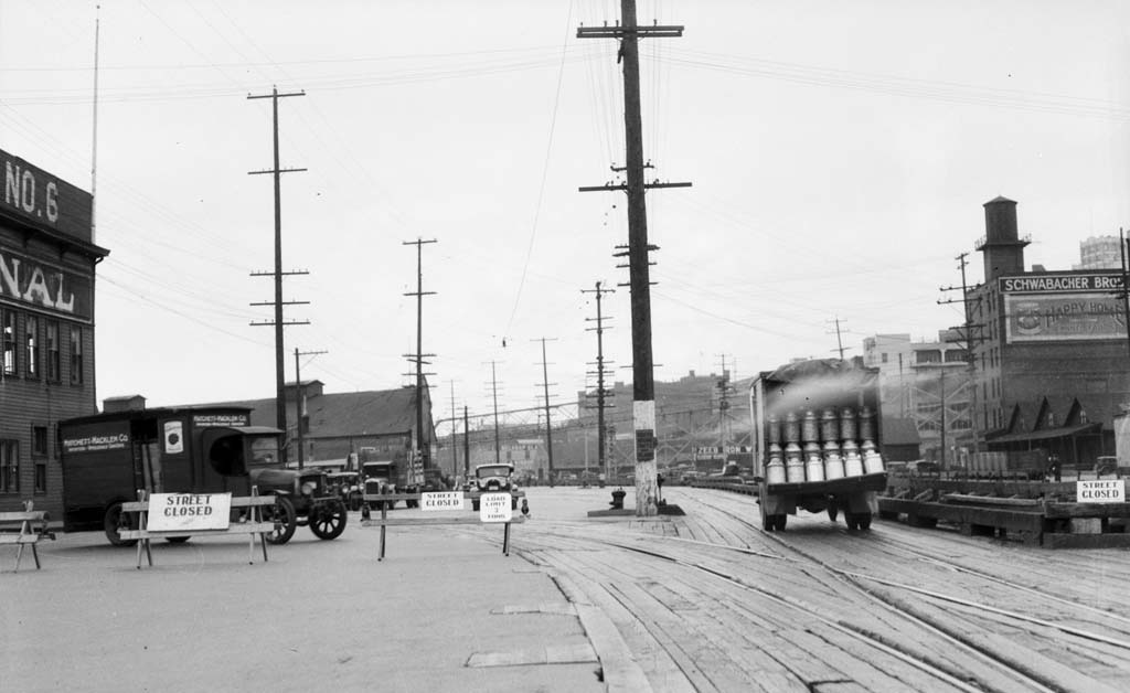
Until the 1910s, Seattle's downtown street system served its needs fairly well. Most people came into downtown via transcontinental and regional trains, streetcars, or steamers on Puget Sound. Hills made it difficult to find level ground, but in 1887 the city made room on the waterfront for railroad lines by creating Railroad Avenue, an elevated thoroughfare that rested on pilings above the beach. Trains and wagons used Railroad Avenue to reach the piers where passenger and cargo ships and the smaller Mosquito Fleet steamers docked.
With the advent of motorized vehicles, the first of which came to Seattle in 1900, the demands placed on Seattle's street system, including the deteriorating wooden Railroad Avenue, increased significantly. City engineers studied the situation and found that traffic on Railroad Avenue had increased 273 percent between 1915 and 1920. The central business district struggled to handle the traffic coming into downtown, and increasingly, passing through downtown to destinations to the north and south of the city.
Traffic studies found that after about 1914 most traffic entered the central business district from the south via E Marginal Way and 4th Avenue S. From the north, bridges across the ship canal and Lake Union funneled traffic onto Elliott, Westlake, and Eastlake avenues. As roads between towns developed during the 1910s and 1920s, an increasing percentage of the traffic made its way through the city, adding to traffic volumes, but needing no access to downtown destinations.
Debating Tunnels and Viaducts
In 1916, Superintendent of Public Utilities Albert Valentine (1868-1931) proposed a tunnel from the waterfront to 8th Avenue, near Lake Union, for railroad use, along with a shift in industrial uses to that area of town. Having removed most of the train traffic from the waterfront, Valentine suggested, the city could remove some of the tracks from the waterfront and replace them with a street to handle the drivers that wanted to bypass downtown Seattle.
In 1928, the Engineering Department proposed easing traffic on downtown streets by developing better connections between the northern and southern entrances to the city and Railroad Avenue. The Streets and Sewers Division's annual report included a recommendation that the city build a viaduct between Seattle Boulevard and 4th Avenue S (near where today's S Industrial Way meets 4th Avenue S) and Railroad Avenue near Railroad Way (about where today's S Dearborn Way meets Alaskan Way). It also recommended a ramp-like street between Railroad Avenue and Elliott Avenue. The viaduct would carry traffic over rail yards and the ramp-like street would carry traffic up the bluff that fronted Railroad Avenue between Pike and Wall streets by angling up the hill.
Variations on this plan appear throughout the 1930s, driven by ever-increasing traffic and road construction that placed pressure on downtown streets. In 1932, with the construction of the George Washington Memorial Bridge (better known as the Aurora Bridge), U.S. Highway 99 brought traffic straight into downtown, with the limited access roadway ending at 7th Avenue and Denny Way. Through traffic then had to thread its way through downtown until it reached 4th Avenue S.
Alaskan Way
Additionally, the city completed the seawall on the central waterfront in 1936, behind which it added fill and built a paved street, Alaskan Way, to replaced Railroad Avenue. The improved route along the waterfront proved attractive to motorists and city engineers, who placed signs directing truck traffic to use Alaskan Way as a bypass route to get through town.
As much as motorists and city engineers liked the idea of a waterfront bypass street, railroads and business owners on the waterfront abhorred it. Their active opposition to building Armory Way, the proposed ramp-like street up the hill, along with limited funding during the Depression, prevented the project from moving forward.
Dreaming the Viaduct
Meanwhile, the viaduct concept also continued to develop. In 1934, according to a State Department of Highways News article about the viaduct, state engineer Ray M. Murray (1876-1955), who had been in charge of the Aurora Bridge construction project, sketched out a route for a waterfront viaduct on a map. It started at Wall Street in the north and crossed over to 4th Avenue S at a point just south of King Street.
In 1938, the Seattle Traffic & Safety Council, a private organization, produced a report urging the city to develop Armory Way along the slope at the north end and a four-lane roadway along the waterfront as a short-term solution to traffic problems. Looking to the long-term, the council recommended a viaduct with a tunnel connection to Aurora Avenue.
The next year, city traffic engineer James W. A. Bollong (1885-1968) proposed a viaduct for the waterfront, which would connect with another viaduct on Dearborn Street (one block north of today's Royal Brougham Way) and 1st Avenue S, go across the industrial district to a tunnel through Beacon Hill and connect with the Lake Washington Floating Bridge (then under construction). A sketch of the plan appeared in the Seattle Post-Intelligencer, but City Engineer Charles L. Wartelle (1885-1954) dismissed the plan as "dream stuff" ("Viaduct Called 'Dream Stuff'").
Dire Problems, No Solutions
By 1939 the traffic situation on all north-south streets in Seattle between Alaskan Way and Boren Avenue had become dire. The Propeller Club of the United States Port of Seattle chapter published a report that included photos of traffic backed up on Alaskan Way, blocking access to piers. The club decried the use of Alaskan Way as a bypass route, but offered no alternatives. Development stretched across the hills to the shore of Lake Washington. Just as when Railroad Avenue was created in 1887, the only space available for a downtown bypass appeared to be the waterfront.
Other cities' transportation systems bolstered the idea for a downtown bypass. Chicago, New York, and St. Louis all built bypasses and improved the traffic flow through their cities and their downtowns. The Chicago and New York roads, Wacker Drive and West Side Elevated Highway respectively, relied on grade separations to improve the effectiveness of the bypasses.
Nothing seems to have come of the viaduct plans in Seattle and a lawsuit filed in 1941 challenged the Amory Way development on the grounds that financing its construction would cause the city to exceed its debt limit. Though the city had already carried out some condemnations for the project, no further development of Armory Way occurred.
War Years
During World War II, the military took over the central waterfront, excluding all other traffic from some roads. Defense operations utilized rails, piers, and streets to move supplies and troops in support of the war effort. Rationing, limited access to new cars and trucks, and staggered shifts at Boeing and shipyards helped keep downtown traffic manageable.
In 1941 the state legislature authorized cities to save unspent money from their wartime budgets in cumulative reserve funds because a shortage of materials and labor made it difficult to carry out improvement plans that would be needed after the war. In 1943, the Seattle City Council asked each city department to create a list of proposed improvements for the first five years after the war. The 1943 Engineering Department annual report listed:
"a Freeway on Alaskan Way ... providing a route for traffic from the north and south, around and adjacent to the central business district. Suggested route would be: Wall St. or Broad St. from Aurora Ave. to Western Ave. by depressed highway; Western Ave. and Alaskan Way from Broad St. (or Wall St.) to Railroad Way (or Atlantic St.) by means of six-lane elevated highway; thence by elevated viaduct easterly to Beacon Hill; said viaduct to be connected by means of ramps at 1st Ave. S., 4th Ave. S. and at Airport Way; thence by means of tunnel through Beacon Hill and across Rainier Ave. to connect with Federal Highway No. 10 at Atlantic St; connecting ramps to be constructed from the Rainier overpass to Rainier Ave" (Engineering Department Traffic Division Annual Report, 1943, 60).
In a final report on post-war improvements issued in 1945, the Engineering Department's Streets Division proposed a list of 31 projects including street repairs, paving projects, bridge and bulkhead construction, roadway extensions, and the viaduct with a depressed (below-grade and uncovered) roadway connecting it to Aurora Avenue. The viaduct, the most expensive item on the list, ranked 29th in priority, out of 31 projects.
Later in 1945, the viaduct idea reappeared, now at the top of a much-smaller post-war-improvements list, though the reason for its increased importance is not given. In 1946 City Engineer Wartelle described the proposed viaduct as a single-deck freeway, with no access between Virginia Street on the north and its terminus near Dearborn on the south. He envisioned adding a second deck later to separate north- and southbound traffic, and then adding access ramps to and from downtown.
During the spring of 1947, City Traffic Engineer Bollong wrote a series of memos to Charles Wartelle that appear to be summaries of discussions they were having. They seem to have agreed on a six-lane, two-deck roadway, with downtown access ramps at Seneca and University streets, a possible wye (a Y-shaped extension) at Railroad Way S to extend the elevated route over railroad tracks to the east of the viaduct, and a four-lane roadway south of Holgate Street. The wye did not appear in any further discussions and shortly Bollong would write that the southern extension should have six lanes due to anticipated traffic volumes. Bollong and Wartelle also appear to have agreed that the connections for the downtown ramps and the space for associated acceleration and deceleration lanes should be built into the viaduct, but that the ramps should be delayed until later.
And Now, for the Viaduct
In May 1947, city engineers met with representatives from the State Department of Highways and the U.S. Public Roads Administration to look over the plans. They agreed that there should only be on and off ramps to and from downtown for southbound traffic, that the northbound entrance to the viaduct should enter from 1st Avenue S, and that the southbound exit should enter traffic on Railroad Way or Alaskan Way. The next month, the city engineers met with the mayor and city council, which approved the general plan for the viaduct.
The city looked to state and federal money to help fund the project. The Federal Aid Highway Act of 1944 allocated money for the first time to the study and development of urban highways. In 1945 the state Department of Highways and the United States Public Roads Administration initiated an origin and destination study of the Seattle area, interviewing thousands of drivers, passengers, and residents to determine traffic patterns in the region.
The origin and destination report, published in 1947, reiterated what several city traffic studies had already determined, that a large percentage of traffic on city streets was through traffic moving to the north and south of the city. The report offered solutions to moving people around the central business district on all sides. Two north-south routes, one along the waterfront and a second on the eastern side of the downtown core, roughly following 6th Avenue and including a new high bridge over the ship canal, would carry traffic through the city.
Three pairs of circumferential routes would carry traffic east and west between Puget Sound and Lake Washington. The inner circumferential routes would lie close to the business district. The median pair would run just north and south of the city limits, and the outer route would travel from Everett in the north around the east side of Lake Washington and back to Puget Sound on the south near Burien, somewhat along the lines of state routes 405 and 518 today.
A report on preliminary plans for the viaduct followed just a couple of months after the release of the origin and destination study. It explained that engineers had changed the viaducts specifications from a single-deck, four-lane structure to a double-deck, six-lane structure. The plans called for ramps connected from both levels to downtown streets. The preliminary report says the viaduct will be constructed with steel and reinforced concrete, but does not specify what the design will be. In a drawing published in The Seattle Times, it appears to have been originally designed as a steel structure with concrete roadways and supports, with much less bulk than the structure that was eventually built. The report's author, Charles Wartelle, also recommended the purchase of the needed right-of-way at Denny Way and 6th and 7th avenues to allow for the construction of a curved street from Battery Street to Aurora Avenue.
Planning and Paying
Placement of the on and off ramps at the southern end of the viaduct posed difficulties. The first phase of construction would bring the viaduct to Railroad Way S, at which point northbound traffic would enter and southbound traffic exit until later stages of the viaduct's construction to the south were completed. The engineers had to accommodate 1st Avenue S vehicle traffic, train traffic along Railroad Way S, and operations at the Union Pacific Freight Terminal at one corner of the intersection. The plans that accompany this report show the ramps placed in the middle of 1st Avenue S, which local business owners opposed.
At the north end, the viaduct would connect with city streets at 1st Avenue and Battery Street, with plans to build a depressed roadway along Battery to connect traffic to Aurora Avenue. Because the viaduct would open before the depressed roadway would be built, the engineers designed temporary ramps at Battery that would be lowered when the new roadway was built.
In November 1947, the city passed a resolution committing the city to providing an additional $1,360,000, for a total of $1,495,000. The state earmarked $1,945,000 out of the State Development Fund, and the federal government agreed to contribute $1,500,000 out of the Federal Aid Highway Bill of 1944 for the Battery Street to King Street portion of the project.
Architects Weigh In
As the viaduct plans evolved, The Seattle Times sought the opinion of local architects. Architect Paul Thiry (1904-1993) called the project "half-baked" and called for a tunnel "superhighway" to handle all downtown traffic. He worried that the viaduct would create a blighted neighborhood in its shadows and "destroy the flexibility of waterfront railroad and truck traffic" (Heilman, "Tunnel, Not Viaduct").
Other architects were not so fundamentally opposed to the idea, though they had reservations. John T. Jacobsen thought, "A finer solution would be a freeway -- an arterial with sufficient land on either side so it wouldn't be encroached on by commercial or residential enterprises" (Heilman, "Landscaped Freeway"). Talbert Wegg warned that if the city built freeways that eased travel between downtown and the suburbs, more people would move to the suburbs, taking the city's tax base with them. Joshua Vogel, an architect and a planning consultant at the University of Washington, supported freeways and balked at the idea of a tunnel because of the expense and difficulties involved in building it.
Business Owners and Their Concerns
As planning progressed for the viaduct, individuals and business owners began to raise issues with the placement of the viaduct and its impact on their businesses. A number of waterfront business owners expressed concern that the viaduct's columns would block their loading docks and impede their operations. They asked that the viaduct be shifted to the west, to the margin of Alaskan Way, where the railroad tracks lay, rather than farther to the east, where cars and trucks parked and where businesses accessed their loading docks. Also, they felt the "bulges" for the planned ramp connections to Columbia, Spring, Seneca, and University streets and the acceleration and deceleration lanes were too intrusive and brought the structure too close to the buildings.
The City Engineer replied to their concerns by noting that studies had already determined that the columns' placement left them sufficient room for their operations. He explained that if they shifted the viaduct to the west, the railroads would have to relocate their tracks under the viaduct, an enormous expense and doing so would subject the structure to the wear and tear of locomotives' exhaust. Furthermore, it was unlikely that the federal government would fund a road without connections to downtown.
In January 1948 two candidates in the mayoral election, M. J. Comber and Melvin G. Tennent (d. 1969), ran on the promise that they would halt the viaduct project if they were elected. Neither candidate made it past the February primary, and the issue does not seem to have been a prominent one in the general election.
Opposition to the location of the northbound ramp in the center of 1st Avenue S was led by a group of 300 business owners, the First Avenue Business Men's Association. They protested that the ramp would require the removal of too much street parking and cause too much disruption in their businesses. In a letter to a waterfront business owner about the complaints, the City Engineer's office wrote, "We feel that the city officials and all good citizens should do everything possible to construct this facility in the manner which will best serve the general public, regardless of the fact that certain interests may be inconvenienced to some extent" (Wartelle and Will to Hibbard).
Planning and More Planning
The next year, the new City Engineer Ralph Finke (1901-2003), previously a state bridge engineer, produced a second report on preliminary plans for the viaduct. In its introduction, Finke explained that of the two north-south expressways recommended in the federal study, the Alaskan Way Viaduct was chosen for construction first because a large segment of the completed route, Aurora Avenue north of Denny Way, was already built and the viaduct's route was located on the right-of-way of an existing city street, Alaskan Way. Also, the viaduct would add usable space to downtown, while the proposed eastern route would replace space that was already in use along 6th Avenue with a new use.
Finke's report addressed concerns about support column interference with ground level operations with several analyses of truck movements in relation to the viaduct and adjacent buildings. Diagrams in the report show that trucks would be able to maneuver sufficiently between the columns and the buildings' loading docks.
Regarding the ramps in 1st Avenue S, Finke recommended that they be moved out of the center of the roadway, but that access to the viaduct remain on 1st Avenue . rather than be moved to Alaskan Way or another street, to avoid disrupting local businesses. Finke suggested that work to carry the viaduct to its planned connection with the Spokane Street Viaduct be completed as soon as possible because traffic was only going to get worse.
Finke also recommended that the viaduct be extended to Holgate Street, south of Dearborn Street, then brought down to grade and continue to Spokane Street as a surface street. He anticipated that ramps to downtown streets should be built, but not that the viaduct should be considered a speedway:
"It should be emphasized that the term free-way does not mean a speed-way. High speed is not an inherent requisite of a freeway, and there is no thought that a speed limit in excess of 35 miles per hour will be either desirable or tolerable on the Alaskan Way freeway at any point on its entire length. In fact, the maximum speed for which there is any authority under State law is 35 miles per hour. The basic principle of freeway design is the control of conflicting movements to insure the free flow of the maximum volume of traffic at a reasonable speed but above all, SAFELY, SMOOTHLY and without stoppages or interruptions. The design of the Alaska Way freeway project adheres to this principle" (Finke, Alaskan Way Viaduct, 3).
Beauty and Earthquake Safety
The 1948 preliminary report also included a discussion of aesthetics. Finke emphasized that because utilities would move to the viaduct, the unsightly poles with jutting arms would be removed, the viaduct would mask unsightly low-level buildings behind it, and it would not dwarf its surroundings. Additionally, it would offer a scenic drive that would be popular with tourists.
Despite these beneficial attributes, Finke conceded, "However, it is not beautiful," and suggested its deficiencies could be lessened by making some adjustments to the design that would balance its proportions. If these were made, Finke wrote, ""I can see no justification whatever in any criticism of the viaduct that is based on esthetic considerations" (Finke, Alaskan Way Viaduct, 12).
Responding to a letter from Oliver R. Dinsmore (1890-1974), a state highway engineer, about how the viaduct has been designed for earthquake, Finke outlined the load that had been applied to the design. On the north end, where the viaduct would split into two separate structures, no earthquake load was applied because it would rest on firm ground. On the double-deck section, Finke explained, "an earthquake load of .05 gravity in any horizontal direction was used in the design. This load is applied simultaneously with dead load, live load, impact, temperature and traction. Earthquake and wind loads are not used simultaneously" (Finke to Dinsmore). (The dead load of a structure is the weight of the structure itself; the live load is traffic.) It is possible that the April 1949 earthquake, which had a magnitude of 7.1 and did extensive damage to Pioneer Square buildings, prompted the inquiry.
More Discussions, More Plans
In the early summer 1948 two organizations and a business owner approached the city with concerns over the process by which the viaduct had been planned. James M. Ryan of the Building Owners and Managers Association of Seattle wrote to Mayor William F. Devin (1898-1982) not to oppose the viaduct in principle, but to express his concern that it had not been fully studied. Among the 13 questions listed in the letter, Ryan asked, "Is it the best and most effective solution of the traffic problem?..."What will be the effect on the waterfront and its future development? ... What can be done to prevent the Viaduct becoming an eyesore?" (Ryan).
R. S. Hawley of the Central Building Company wrote a letter addressed to the mayor, the chair of the City Council's Streets and Sewers Committee, Ralph Finke, the City Planning Commission, the Public Roads Administration, and the State Highway Department expressing his multiple concerns about the cost, the effect of the viaduct on the surrounding properties, its design, and that "it would always remain an unsightly structure along our very valuable waterfront" (Hawley).Someone, presumably in the Engineering Department because the letter was in its files, wrote terse refutations of the points raised by Hawley in the margins. In reply to Hawley's suggestion that the issue be further studied, the commentator wrote "We have waited too long now!" (Hawley).
The Municipal League's Floyd Naramore (1879-1970), an architect, wrote to the City Planning Commission to suggest that the commission look again at the viaduct plans. They had only looked at them once, in 1944, when the structure had a different design and different components. The Municipal League did not oppose the viaduct, but Naramore suggested that the commission review the effect it will have on the city's overall development and "its general appearance" (Naramore). The commission looked again at the plans in June 1948 and approved them because it ""conforms to the accepted principle of having through traffic by-pass congested business areas," allowed access to downtown, and it fit with the long-range plans for transportation in the city (Holmes).
Planning continued on the plans for the viaduct and the Battery Street connection with Aurora. In February 1949 the city engineers announced that a subway would be built at Battery Street because the cost of condemning the property involved in building a depressed roadway cost more than covering the roadway with a new street.
Changes and Rearrangements
In March, legislation passed in Olympia shifted some of the jurisdiction for State Route 99 to the State Highway Department (it had previously been in the City's jurisdiction), allowing the state to fund the viaduct construction entirely. This allowed the City to shift its funding to the southern extension of the roadway from Holgate to Spokane Street, which would speed completion of the project and reduce the amount of time that traffic to and from the viaduct used city streets in the industrial district just south of downtown.
By November 1949, engineers completed plans for the Schedule B part of the viaduct, from Battery Street to Pike Street. It appears that Finke's design suggestions were implemented. The drawing of the planned structure published in The Seattle Times is the design that was built, with substantial columns and solid span supports.
In 1950, the City developed plans for the Schedule C (Pike Street to King Street) portion of the viaduct, while the Bridge Division of the State Highway Department designed the Schedule D (S King Street to Railroad Way S) portion of the viaduct. In 1956 the contract was let on the southern extension of the viaduct, from the end of the elevated structure to East Marginal Way and Dakota Street. The state funded this portion of the project, shifting the City's funding to the construction of underpasses at Mercer and Broad streets.
The final design for the southern extension called for a surface street south of Holgate, a viaduct over the Spokane Street Viaduct with exit for southbound traffic to West Seattle, and an on-ramp for northbound traffic from West Seattle. The roadway returned to ground level on the other side of Spokane Street and joined with E Marginal Way.
Planning also began for the Battery Street Subway and for widening Aurora to Broad Street (Schedule A). This was the first vehicular subway built in Seattle and the first one designed by the City's Engineering Department. It is the only one lined with concrete rather than with tile. In January 1951, the state Highway Fund allocated $2,300,000 for the complete cost of the tunnel's construction. This allowed the City to use a new type of ventilation system rather than the forced-draft ventilation system that the federal government required for tunnels on which federal funds were spent. The tunnel's design relied on exhaust vents in the ceiling that allowed air to escape to the street surface above. Thirty-six pairs of fans pulled in fresh air from street above.
The engineering department conducted studies of air quality on Battery Street during June and July 1951. They measured the carbon monoxide levels in the air just above where the fans would be located on a day with little wind. They also tested low level air on a street downtown with highrise buildings and long distances between cross streets in anticipation of those conditions developing on the relatively less developed Battery Street. The department also worked with Professor Gordon P. Campbell from the Mechanical Engineering Department at the University of Washington to create and test models of the ventilation system.
The alignment of the Battery Street Subway crossed under the Paramount Building (now the Catholic Seamen's Club building) at 1st Avenue and Battery Street. The city condemned the property and paid the building's owner, Samis Land Company, to move the building out of the way. Samis Land Company balked at the expense and risk of moving the building and offered to forfeit their condemnation payment if the City would move the building to an adjacent lot, taking responsibility for unforeseen costs. The city declined the offer and bought the building instead, selling it again when construction was complete.
Locating the Ramps
In April 1953, with the Battery Street tunnel under construction, focus again turned to the downtown access ramps. A Seattle Times editorial urged their construction, arguing that the Seattle Freeway, today's Interstate 5, would not be built for some time and Seattle's traffic volume continued to grow. The city was looking at the 1957 state budget for funding for the ramps, but the Times wanted the city to move forward before then.
But the City had to find funding for the ramps and determine how to integrate them with a one-way-street system that had been proposed for Seattle's downtown streets. The engineers wanted to bring the ramps into downtown via existing east-west streets to 1st Avenue, so that the ramps would have a more gradual grade than if they tried to take them to Western Avenue, one block east of the viaduct. In planning documents, Spring, Seneca, University, and Columbia streets are often identified as the most likely routes for ramps. In 1955, however, the City looked at other alternatives, including Union Street.
While the City sought funding, discussions continued about how many, if any, ramps there should be between the viaduct and downtown streets. The City could choose to do four ramps, an off- and on-ramp for both directions. Or, it could build just two, an off- and on-ramp for the southbound traffic. The northbound traffic could enter and leave the viaduct close to downtown, at Battery Street. Or, it could forgo ramps and leave the viaduct a bypass route, intended only to carry traffic around downtown (though the ramps were part of the package funded by the federal government). Downtown business organizations supported adding all four ramps. Some engineers wanted it to remain a bypass route.
Design on the last piece of the viaduct, the Columbia Street on-ramp for southbound traffic, did not start until 1965. In 1958 James Robertson, an assistant city engineer, told the City Council that the city engineers opposed building ramps before the southern extension of the highway to Spokane Street and underpasses at Mercer Street and Broad Street opened. The extension was scheduled to open in 1959 and the underpasses later in 1958. In February 1960 the state funded an off-ramp at Seneca Street, which opened in 1961.
According to the Historic American Engineering Record report about the Alaskan Way Viaduct, in the decade since the design of the viaduct, the public had become more involved in evaluating the aesthetics of public works. New regulations required that the design go before the Municipal Arts Commission for review. The commission asked that the design be as "clean" as possible with the intention that street-level uses be impacted as little as possible (Sheridan, 24-25).
The City Council put a bond issue before the voters in 1960 for the remaining three ramps, but it did not pass. The Columbia Street on-ramp finally received funding from city-issued bonds in 1965. The other ramps were delayed pending the results of a downtown study -- and never constructed.
To go to Part 3, click "Next Feature," to see Part 1, click "Previous Feature"
