In 1909, the Puget Sound Bridge and Dredging Co. finishes building Harbor Island with dredge spoils from the Duwamish River and soil dug and sluiced from Beacon Hill in the Jackson Street and Dearborn Street regrades. It is the largest artificial island in the world at approximately 350 acres. Harbor Island will lose this distinction in 1938 to Treasure Island in San Francisco Bay, but will increase in size and surpass Treasure Island once again in 1967. Today, at least two artificial islands are larger. (In the Port of Kobe, Japan, Port Island, completed in 1981, is 1,064 acres, and Rokko Island, completed in 1992, is 1,432 acres.)
Tidal Flats and Deltas
"The southern end of Elliott Bay was occupied by tidal flats and deltas of the Duwamish River," according to retired Port of Seattle engineer George Treadwell. "The entire delta area was crisscrossed by many small, shifting channels. This tidal delta dropped sharply to the general depths of Elliott Bay along a line which is now [1969] the northern edge of Harbor Island ... Low islands, subject to flooding, covered parts of the area that is now Harbor Island" (Seattle P-I).
In 1900, the Seattle General Construction Co. obtained a permit to fill the tide flats at the mouth of the Duwamish River. The contract to build an island went to the Puget Sound Bridge and Dredging Co. Soil from the Beacon Hill regrade operations was sluiced in large pipes using placer mining technology. Silt from the bottom of the river was brought up by dredges to deepen the channel. A total of 24 million cubic yards of soil became Harbor Island.
Charles Butler and His Chickens
In 1906, the only resident of the soggy area was Charles Butler, his dog, his Angora goat, and 300 chickens. He rowed a boat to Seattle twice a week for supplies and to sell chickens. Butler expressed puzzlement that the submerged area around his chicken coops could be worth millions of dollars. He had no title to the property and had to move when the owners needed it.
Harbor development in Seattle was spurred by plans to construct the Panama Canal. Cities such as San Diego and San Francisco planned improvements that would make them the focus of trade in the eastern Pacific. The master plan for Seattle offered by Virgil G. Bogue (1846-1916) in 1911 included seven 1400-foot piers on Harbor Island. Such an ambitious development ran contrary to the plans of General Hiram M. Chittenden (1858-1917), commissioner of the newly formed Port of Seattle. He was not convinced that the level of trade would justify the expense.
A Private Enterprise Island
Another scheme in 1911 by some New York and Seattle businessmen required the Port to issue more than $7 million in bonds for a large terminal on Harbor Island. Focusing the Port's resources on Harbor Island would leave the Seattle waterfront in the hands of private interests. General Chittenden opposed the Harbor Island terminal scheme. He wanted instead to build Port facilities in Salmon Bay, Smith Cove, and along the downtown waterfront. But Harbor Island dwarfed other issues in the election and voters approved all the Harbor Island measures.
Chittenden managed to include on the ballot a requirement that private investors post personal bonds before construction could begin. When the construction bonds did not appear, the Port was able to have the Harbor Island bond issues canceled in 1913. Harbor Island was left in the hands of private enterprise, and the Port of Seattle continued its development across Elliott Bay on the Seattle waterfront.
Ship Building and Flour Milling
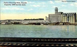
One of the first industrial concerns to move in was Fisher Flouring Mills in 1911. Puget Sound Bridge and Dredging started Associated Shipyards on the island. During World War I, Associated constructed the two largest wooden steamers in the world. Todd built a shipyard there in 1918.
In 1938, Treasure Island in San Francisco Bay was completed as a site for an airport and it topped Harbor Island at 395 acres. But, by 1967, gradual filling over the years would increase the size of Harbor Island to 396.7 acres.
Earthquake Experiences
Because the island is fill on top of a river delta, it is seismically unstable. During the earthquake of April 13, 1949, parts of the island rose as much as 16 inches and other parts dropped 12 inches. In the April 29, 1965 temblor, Pier 15 and Pier 16 on the East Waterway moved 12 inches closer to Seattle.
On February 28, 2001, seismologist Bob Norris was on the island during the Nisqually Earthquake. In addition to extremely strong shaking, he described eruptions of muddy water from the liquefaction of subsurface soil making him think that a water main had burst. "This geyser issued three or four very fluid splashes over the next few seconds, about a yard high each, then it widened and collapsed into a column about half that wide that discharged a tremendous volume of muddy water. This flood emerged much faster than it could spread, so that within a few seconds the flow front had become a surge several inches high, like a small wave traveling up a dry beach. Its velocity was near 3ft/second as far as I could tell. Within an estimated 30 seconds, the surge had grown into a shallow rotating pool about 25 feet across with bits of suds floating on it, still vigorously fed by the column of water at the original breakout site" (U.S. Geological Survey).
In 1983, lead contamination from a variety of industrial sources caused the U.S. Government to place Harbor Island on the National Priority List of polluted sites. Some of the contaminated areas were remediated in 1996.
In 2001, Harbor Island was home to the Port of Seattle's 106-acre Terminal 18 with berths for five container ships, Todd Shipyards, and several petroleum terminals.

