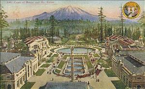
On May 17, 1907, the University of Washington's Board of Regents approves the plan for the grounds of the Alaska-Yukon-Pacific (A-Y-P) Exposition, a world's fair to be held on campus from June 1 to October 16, 1909. John C. Olmsted (1852-1920) of the Olmsted Brothers landscape architecture firm had developed the plan over the previous several months. It would transform the forested campus into a park for the world's fair and into a future site for the growing university. Upon the regents' approval of the plan, a two-year frenzy of construction begins.
Vistas of Mountains and Lakes
Olmsted's plan encompassed the southern portion of the campus, from 41st Street south to the shores of Lake Union and Lake Washington, which the Alaska-Yukon-Pacific Exposition Company leased from the university. In creating the plan, Olmsted had to consider how the university would use the area and the four buildings planned as permanent after the fair. In contrast to other world's fairs of the era, the A-Y-P's design drew its inspiration from the surrounding landscape.
Three vistas, Lake Washington, Lake Union, and Rainier, drew the surrounding lakes and mountains into the design. The fair's buildings, paths, and avenues were laid out around the axes created by the vistas. The final plan bore many of the traits characteristic of other Olmsted designs such as incorporating surrounding landscape; taking advantage of the site's topography including curving, meandering paths in the less formal areas; using native plants; and designing water features as focal points.
The Alaska-Yukon-Pacific Exposition Company had invited John C. Olmsted (1852-1920) to design the exposition grounds in October 1906. His preliminary plan utilized all of the land between 41st Avenue and the lakes. It incorporated the university’s needs, the roads that would need to be constructed and the land each department of the exposition stated it would need, though, according to Olmsted, “In fact, to meet demand for space it would have required over 100 acres of land to be created by filling out into the shallow waters of the Lake Washington bay” (Olmsted to Sheffield). Instead, he fit everything onto the existing land. The plan also allowed for a significant amount of existing forest and undergrowth to remain between the buildings.
Rainier Vista, still a prominent feature of the campus, formed the primary axis for the design. At the top of the vista the Court of Honor overlooked the two central water features: the Cascades and the Geyser Basin, which survives today as Drumheller Fountain. Immediately below the fountain lay formal gardens, followed by an expanse of lawn bordered by flower beds and paths framed by Douglas firs, carrying the eye to Mount Rainier in the distance. Branching off from the fountain, the Lake Union and Lake Washington vistas, also framed by Douglas firs, drew visitors' eyes to the lakes in the distance.
Curved Paths and Avenues
Paths and avenues ran between buildings clustered around circles. Pacific Avenue followed the same route as the southern portion of today's Stevens Way. On the other side of the railroad tracks, now the Burke-Gilman Trail, were the model farm, stock exhibits, and the park, a remnant forest through which ran trails for strolling, giving fairgoers an escape from the bustle and formality of the fair.
The Pay Streak, the fair's midway, ran along the western side of the grounds from just to the south of the main entrance to the water’s edge. There visitors could enjoy rides and shows, dine at numerous restaurants and food stands, or buy souvenirs.
Early Ideas
Some of Olmsted's proposals from the preliminary plan did not come to fruition. Hired before the company employed the fair’s supervising architect, Olmsted suggested that the major buildings of the fair be designed in what he called an "ancient Russian" (Olmsted to Smith) style to honor the Russians' early colonization of Alaska and because the spires of the roofs would complement the towering evergreen trees that would remain on the grounds. Once hired, the supervising architect, John Galen Howard, decided not to pursue this idea because of its unfamiliarity to the numerous local architects who would be collaborating on the project.
Olmsted also included an "intramural electric railway" (Olmsted to Smith) to transport people around the grounds on an elevated track in the preliminary plan. This did not survive in the final plan. Instead, the fair featured rickshaws that could be rented, providing summer jobs for a number of college students.
Designing to Budget
Between November 5, 1906, when Olmsted finished the preliminary plan for publication and May 17, 1907, when he presented the final plan to the regents, the overall structure of the plan did not change. To reduce costs Olmsted tightened up the design, reducing space between buildings and moving the bulk of the fair's structures north of the railroad loop (now the Burke-Gilman trail). The reduced costs in building paths and avenues, planting flower beds, and laying sod brought the plan's cost within the $380,000 budget.
Olmsted located the permanent buildings that the Washington State A-Y-P commission planned to build on the upper end of the grounds. This placed them in proximity to existing campus structures, including Denny Hall, Parrington Hall, Denny Field, and the men's and women's dormitories (today Lewis Hall and Clark Hall), that lay north of 41st Street.
Once the Board of Regents approved the plan, work started immediately. Crews had just two years to complete the grading, landscaping, road building, and construction required to transform the forest into the grounds for a world's fair.

