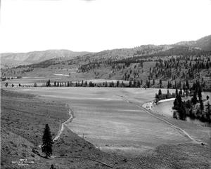
On August 31, 1908, the Methow Canal Company pipeline across the Methow River is completed. The pipeline is part of a new irrigation system that will draw water from the Twisp River, above the town of Twisp, and distribute it to farmers in the Methow Valley in Okanogan County in North Central Washington. Starting in 1919, the Methow Valley Irrigation District will manage the canal. Water provided by the irrigation district will allow area farmers to greatly increase the yield of feed crops, thereby expanding dairy and livestock operations; make possible the development of large apple orchards in the valley's rich soil; and help promote the growth of towns along the Methow River, from Pateros at the south to Mazama in the north.
Early Irrigation
The Methow Valley's rich soils drew new settlers to the valley beginning in the 1880s. Not deterred by the area's low rainfall rates, they soon began using irrigation to take advantage of local rivers fed by slow-melting snowpack in the Cascade Mountains. After the turn of the century, the pace of irrigation development increased and about 20 systems were built in the first decade of the twentieth century. The Methow Canal Company was one the larger ones, intended to supply about 3,000 acres.
Thomas Blythe, a Scottish immigrant who had already established himself as a cattle rancher near Moses Lake, turned his efforts to irrigation and formed the Methow Canal Company in 1905 to deliver water to farms between Carlton and Twisp along the Methow River. The company built an irrigation system over the next three years that drew water from the Twisp River about four miles above the town of Twisp and brought it down into the valley in an open ditch. To carry the water across the Methow River, the canal company hired a firm to build a 3,500-foot wood-stave pipeline with an inverted siphon to push the water from the river uphill to the canal running along the eastern side of the valley.
Irrigation water could mean the difference between a valley with sparsely distributed homesteads and a bustling valley full of farms and towns. Spokane's Spokesman-Review reported in 1905 as the Methow Canal Company project got underway that "The greatest need of the Methow valley is transportation, and the people here feel that with the completion of this big project immediate tonnage will be afforded and that a railroad can not much longer remain at a distance" ("Start Work on Methow Canal"). The reporter noted that the Methow Valley lay at a midpoint between Bellingham and Spokane, providing two potential markets for agricultural produce. As it turned out, the closest that trains got was a Great Northern Railway line through Pateros at the southern end of the valley, which began service in 1913, but this was sufficient to support the agricultural economy that grew with the increase in irrigation water.
Methow Valley Irrigation District
The pipeline across the Methow River was completed on August 31, 1908, but problems soon arose. Maintaining the flumes proved difficult and the Twisp River flow did not provide enough water to supply both canals adequately, leaving farmers at the Carlton end of the system without reliable water. In about 1919, a group of farmers formed the Methow Valley Irrigation District to take over the canals. The district built a dam on the Methow River near Twisp and a new eastside canal running from the dam to a connection with the original canal several miles downriver from Twisp. The new system began delivering water in 1922.
The Methow Canal Company and Methow Valley Irrigation District canals were part of a network of irrigation systems that carried water throughout the Methow Valley. The water allowed area farmers to greatly increase the yield of alfalfa and other feed crops, which supported dairy and livestock operations in the valley. The water also made it possible for orchardists to take advantage of the area's rich soil to grow fruit trees and a large apple industry developed. A string of towns grew up along the river, from Pateros at the southern end of the valley to Mazama at the northern end.
Although apple production declined in the 1960s following changes in apple storage technology and a hard freeze in the winter of 1968 that killed many of the valley's fruit trees, irrigation of cropland and a smaller number of orchards continues in the twenty-first century. In response to maintenance issues and increased regulation protecting fisheries, the Methow Valley Irrigation District worked in 2014-2015 to replace its canals with pipelines to reduce water leakage and lessen the system's impact on fish populations.

