Beginning about 14,900 years ago, salmon begin to colonize Puget Sound. During the last ice age, when a 3,000-foot-thick glacier moved out of Canada and traveled as far south as Olympia, no salmon, or any other fish species, could inhabit the Puget lowland. Almost two thousand years would pass before conditions became right for the salmon to enter the recently excavated lowland, which they did when a connection was made between what is now the Strait of Juan de Fuca and Puget Sound.
Carving a Landscape
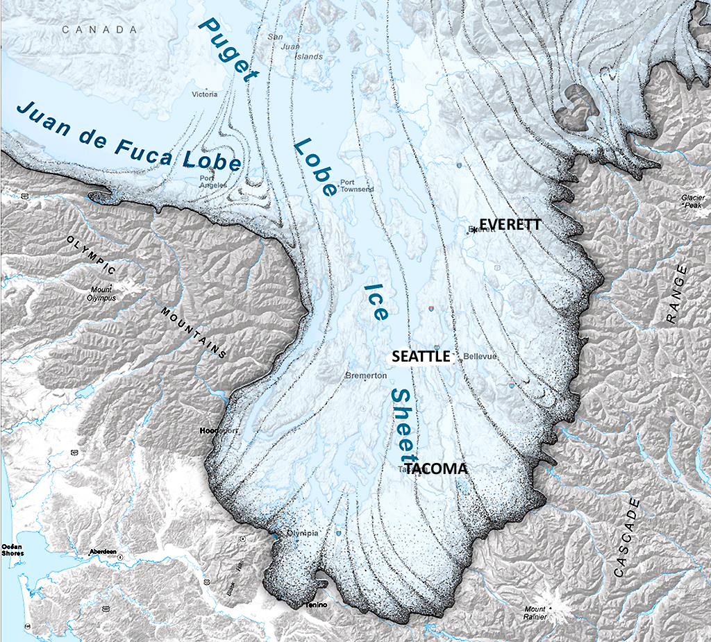
During the last ice age, a great glacier known as the Puget lobe of the Cordilleran Ice Sheet spread across the land. The 3,000-foot-thick glacier slid out of Canada between the Cascade and Olympic Mountains and reached its furthest point to the south, near Olympia, about 17,000 years ago. The ice stalled for a few hundred years, then began to retreat, or melt back, to the north. By about 16,500 years ago, the area around Seattle was ice free and by 14,900 years ago a connection had been made between the Strait of Juan de Fuca and the Puget lowland.
As the glacier moved south it sculpted the land. Most dramatic were the deep incisions caused by water -- the Duwamish River Valley, Lake Sammamish, Lake Washington, and Puget Sound. These features formed when rivers flowing under the ice cut troughs down into the poorly consolidated layers of sediment deposited in front of the glacier. Geologists have estimated that the rivers carried away more than 180 cubic miles of material, or enough material to build 292,000 Great Pyramids of Giza.
When the Puget lobe was present the landscape was mostly devoid of life. Microscopic and some larger life forms could have survived on the icy surface, but otherwise there were none of the plants or animals that dominate the modern environment. At the same time, both land and sea levels were much lower than they are today. The first was due to the great mass of the glacier, which weighed down the land. The second was due to the great amount of water that was held in frozen form in the ice sheets that covered the northern part of the globe. Geologists have estimated that the land surface was at least 660 feet lower than it is today and that sea level was lower by approximately 335 feet to 535 feet.
After the Ice
After the ice retreated north, the landscape began a slow change. Great freshwater lakes initially filled the lowland. They had formed when the ice, acting as a giant dam, prevented the glacial meltwater from escaping north into the area of the modern Strait of San Juan de Fuca. Outside of the lowland, valleys with rushing rivers extended out of the mountains, although the valley mouths were in different locations than they are today. The land itself was mostly barren, having been wiped clean of life during the ice age.
The retreat of the ice also led to the simultaneous rising of the land (called isostatic rebound) and the sea, with the sea level rising about one-half inch per year between 18,000 and 13,000 years ago. The land rose about four inches per year from 16,000 to 12,500 years ago and then slowed to about three-quarters of an inch per year. In the Puget lowland, the great freshwater lakes persisted until about 14,900 years ago, when the combination of sea-level rise and glacial retreat allowed salt water to flow into Puget Sound and the surrounding lowlands. By 5,000 years ago, sea level was about 10 feet lower than it is today.
Salmon Speciation
At present six species of salmon in the genus Oncorhynchus are found along the west coast of North America and the Puget lowland: O. kisutch (coho), O. tshawytscha (Chinook), O. keta (chum), O. gorbuscha (pink), O. nerka (sockeye), and O. mykiss (steelhead, an anadromous form of rainbow trout, which are themselves members of the genus Oncorhynchus). In contrast, only one species, Salmo salar (Atlantic salmon), is found on the east coast of the United States. Paleontologists have proposed that the last common ancestor of both genera lived about 20 million years ago and that the western-species split took place between 20 million and six million years ago. The main difference is topography, specifically the formation of the great western mountain chains and the subsequent development of diverse ecosystems. In contrast, drainages along the Atlantic coast have changed far less in the past 70 million years.
Few salmon fossils have been found. One of the best was unearthed in August 2000 on the banks of the Skokomish River in Mason County. Paleontologists place its age at about 900,000 years old. Based on skull bones and tooth variation, the fossil has been labeled a sockeye salmon. It was found in lake-deposited sediments. Paleontological and geological evidence suggest that the fossil and others nearby were of fish that had migrated to a tributary at the head of the lake, built nests, spawned, and died.
Additional changes to the local species also took place during the Pleistocene (1.8 million years ago to 10,000 years ago). Glaciation, volcanic eruptions, lahars (great mudflows), and megafloods (specifically along the Columbia River, where floods during the last ice age could carry more water than found in all the rivers on earth today) led to significant landscape changes, which would have created new and diverse habitats that fostered evolution within the salmon species. Biologists have proposed that today's species reflect these Pleistocene changes. They include coastal and inland steelhead, spring- and fall-run Chinook salmon, and "possibly odd- and even-year pink salmon" (Waples, et al., 192).
Although the Puget lobe was arguably the greatest shaper of land in recent times, change continued even after the ice retreated. Between about 12,500 and 5,000 years ago, rivers washing out of the mountains and into the lowlands eroded into the glacial sediments, which led to changes in the size, location, and slope of valleys and floodplains. "Such changes may have favored steelhead trout and coho salmon (which utilize small streams of moderate slope), whereas species such as chum salmon were confined to habitats in low-elevation floodplains" (Beechie, et al., 46).
The Salmon Return
Biologists debate when salmon returned to the Puget lowland. It could have taken place in two pulses. In the earlier advance, salmon (in particular steelhead) could have come from the south via the Chehalis River, which would have taken place before the sound became salt water, during the time that large freshwater lakes formed in the Puget lowland. The second pulse would have been from the north, after Puget Sound established a connection to the Strait of Juan de Fuca. Recent studies show that salmon in Puget Sound have close genetic relationships to fish on the Olympic peninsula and Vancouver Island, which would suggest "a more likely recolonization route through the Strait of Juan de Fuca" (Waples, et al.), though this could also reflect that the immigrants from the north were more successful and thus overwhelmed the genetic contributions from the southern salmon.
Throughout most of the post-glacial time, people have lived in the Puget lowland. The most detailed evidence for human habitation (including more than 1,000 stone flakes, hammerstones, scrapers, and projectile points) comes from a site in Redmond, where the artifacts date to 12,000 years ago. On Orcas, a bison dated at 14,000 years old has signs that indicate butchering and possible impact blows by humans, though there is some debate about the human connection. The site at Redmond and other archaeological sites in the Puget lowlands show that Native people fished for salmon for millennia, yet had no negative impact on the overall population.
By about 5,000 years ago, terrestrial salmon ecosystems of the Pacific Northwest looked much like the do today, with salmon swimming in the many stream and rivers that dot the Puget lowland. In some locations change has occurred because of lahars, volcanic eruptions, landslides, wildfires, and floods, but these alterations have done little to change the overall distribution of salmon.
