The Alpine Lakes Wilderness covers more than 414,000 acres within the Mount Baker-Snoqualmie and Okanogan-Wenatchee national forests in the northern Cascade Range of Washington. The wilderness includes parts of Chelan, Kittitas, and King counties. It is bordered by Snoqualmie Pass to the south, by the town of Leavenworth to the east, and by Stevens Pass to the north. The Alpine Lakes Wilderness got its name from its more than 600 ponds and lakes, which offer scenic grandeur and abundant water. The wilderness was created in 1976 by President Gerald Ford and expanded in 2014 by President Barack Obama. Most challenging for its future sustainability, it lies only an hour or two from the heart of Seattle.
Abundant Lakes and Headwaters
The Cascade Range containing these alpine lakes arose during the Tertiary, a period that includes the Cenozoic Era, which began about 66 million years ago; and the Quaternary Period, beginning 2.6 million years ago. Volatile tectonic activity took place, including a vast uplift along a north-south axis of what is now the Alpine Lakes. Most of the peaks along the axis have arisen within what is known as the Snoqualmie Batholith, caused by the uplift and erosion of volcanic rock. Intrusive or plutonic rock forms when magma below Earth's crust is extruded and forced past older rock before slowly solidifying. Glaciation that occurred during the Pleistocene epoch, which ended about 11,700 years ago, created signature U-shaped valleys in many places. Subsidiary mountain ranges within the Alpine Lakes Wilderness include the Chiwaukum Mountains and the Wenatchee Mountains.
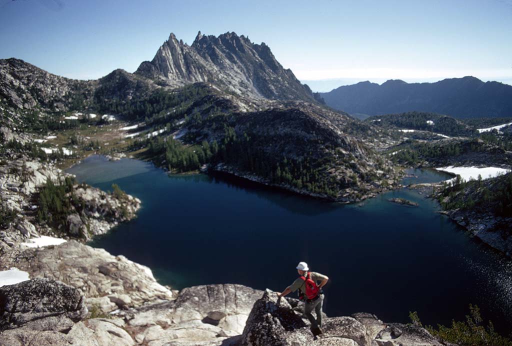
No other area in the Cascades has such a concentration of lakes and ponds. They give the area its name. These lakes are mostly high in elevation, fed by glaciers, and contained in cirques -- that is, bowl-shaped and steep-walled basins, sometimes known as glacial scoops. Heavy precipitation feeds the lakes. Precipitation ranges from 10 inches per year in the eastern portions to 180 inches at the crest of the Cascades. Steep inclines and heavy snows in the winter and spring create avalanche hazards in some areas. Avalanche chutes come into being when slides of snow topple trees and mow down vegetation; these chutes can take decades to recover.
Due to its protected status, the Alpine Lakes Wilderness helps maintain water clarity and quality in the several rivers whose headwaters, or portions thereof, are located within the wilderness. Among these rivers are the Skykomish, the Snoqualmie, the Wenatchee, and the Yakima. As watershed headwaters, the area also contributes flows for domestic and agricultural uses. Water in the Wenatchee River is deemed healthy enough that the Yakama Nation began reintroducing Coho salmon successfully there in 1999 ("Methow and Wenatchee R. Coho").
Carving Routes Through the Wilderness
Long before non-Native settlers arrived in Washington, indigenous people traversed this wilderness on trade routes between the coast and points inland, particularly in the summer and fall. They traveled to hunt bison on the plains of Montana and gather salmon on the Columbia River and tributaries such as the Wenatchee River. Indigenous guides and scouts also helped survey the best wagon routes and montane railways.
A number of place names in the area derived from various Salish bands. Snoqualmie stems from the name for one of them; the word is generally taken to mean "ferocious people." Cle Elum is believed to mean "swift water," while the place name Skykomish is assumed to mean "upriver people." Wenatchee is likewise named for its local indigenous band. Natives in the area proved to be helpful sources of information about supplies and travel for early non-Native explorers.
Like many other geographical features in Washington, Mount Stuart was named for a military man -- Jimmie Stuart, who was killed by an Indian arrow in 1851 and was a close friend of Captain George B. McClellan (1826-1885), leader of the Pacific Railway Survey in 1853. The purpose of the McClellan survey was to plot the path for a railway through the Columbia Basin and the Cascade Range. If the Stuart Range and Mount Stuart impeded that rail route, they are a magnet today for climbers around the world.
Fred Beckey (1923-2017), a legendary climber, wrote one of the definitive climbing guides and histories of the Alpine Lakes Wilderness. Aiming for a climbing audience in his three volumes, the pertinent volume published in 1973 includes a wealth of detail about the region's history. He devoted many pages to Mount Stuart. Beckey wrote, "Without a rival as the crown peak in the Central Cascades of Washington, Mount Stuart has been pronounced the single greatest mass of (exposed) granite in the United States" (302). Its steep incline makes it challenging for climbers. The mountain also harbors glaciers such as Ice Cliff and Sherpa.
Other peaks that entice climbers include Mount Daniel, at 7,986 feet (or 2,434 meters), Jack Ridge, at 7,893 feet, and Ingalls Peak, at 7,662 feet. The first volume of Beckey's Cascade Alpine Guide remains authoritative on climbing routes throughout the Alpine Lakes Wilderness. Beckey himself became the subject of a 2017 documentary film biography entitled Dirtbag: The Legend of Fred Beckey. That film features some scenes in the Alpine Lakes Wilderness.
Protection a Century in the Making
Roads to gain access to logging and mining sites were cut into the Cascades long ago, and such roads account in part for the jagged boundary of the Alpine Lakes Wilderness. The General Mining Act of 1872, which authorized prospecting and mining on federal lands, resulted in considerable damage to the area before 1900. Since then, legislators and environmentalists have placed increasing pressure on federal and state agencies to restore vestigial mining and logging sites and conserve them against further harm.
Full protection for the Alpine Lakes Wilderness came through a series of legal maneuvers a century in the making. The first was the 1897 designation of a Forest Reserve in the North Cascades, an area that included the Alpine Lakes. The Forest Reserve designation was intended to limit commercial logging and other timber removal, to preserve the region for the future, and to avail indigenous people and wildlife (alpinelakes.org). The next significant step came in 1946, with designation of the Alpine Lakes Limited Area. The U. S. Forest Service, which then regulated the area, had been allowing mining, fur trapping, clear cuts, and other forms of logging. Greater legal protections came with the formation of the North Cascades Conservation Council in 1957 and the Alpine Lakes Protection Society in 1968, both of which sought to curtail logging and mining.
Before the area gained full federal protection, though, environmental groups had to do some heavy lifting. These groups included the Wilderness Society, the Sierra Club, the Alpine Lakes Protection Society, and The Mountaineers. They solicited members to write opinion pieces, lobby members of Congress, and perform work behind the scenes.
Two U. S. Presidents, one a Republican and the other a Democrat, finally accorded the area full legal protection under the 1964 Wilderness Act. In 1976, President Gerald Ford (1913-2006) signed into law the Alpine Lakes Area Management Act that made a portion of the area a wilderness. That act was strengthened when four additional portions were entered shortly thereafter into the National Register of Historic Places. Ford's signature was influenced by a coffee-table photo book issued by Mountaineers Books in 1971, The Alpine Lakes. To show him what was at stake, Washington governor Dan Evans (1925-2024) presented the book, at a time when Ford was contemplating H.R. 7792, a bill to make the Alpine Lakes area an official wilderness of some 392,000 acres.
That meeting of leaders from the two Washingtons had an important foreground. Evans had been a Boy Scout and had hiked with future Supreme Court Justice William O. Douglas (1898-1980). President Ford had likewise been an outdoor enthusiast, a hiker, and an Eagle Scout. All the members of the key committee had received copies of the book and were impressed. The President, however, was feeling pressure from the departments of Agriculture and Commerce and from the Office of Management and Budget to veto the bill. "The Forest Service even drafted veto language for him" (Dunau). The scheduled 15-minute meeting between Evans and Ford stretched to 40 minutes. The president then defied his bevy of advisers and signed the bill.
In December 2014, Congress added 22,000 acres to the wilderness as part of the National Defense Authorization Act. President Barack Obama (b. 1961) signed it into law that month. The Alpine Lakes book that was so influential in 1976 – illustrated by Ed Cooper and Bob Gunning, edited by Harvey Manning, and written by Brock Evans -- had become a collector's item, selling for as much as $100.
A Wonderland for Outdoor Enthusiasts
Popular activities in the Alpine Lakes Wilderness include hiking, camping, horseback riding, rafting, rock climbing, and many more. The wilderness includes some 414,000 acres, 47 official trailheads, and 615 miles of trails. Part of the transnational Pacific Crest Trail, frequented increasingly by thru-hikers and more casual visitors, crosses the wilderness from Snoqualmie Pass to Stevens Pass by way of Kendall Peak.
A number of hikes within the Alpine Lakes are family-friendly. The Gold Creek Pond Loop, accessed via the Hyak exit from Interstate 90, is a 1-mile loop ideal for families with children. The Cooper River Trail is 6 miles roundtrip; it follows the Cooper River and is accessed at Salmon La Sac north of Roslyn. Pete Lake is 9 miles roundtrip and gains only 400 feet of elevation. It continues via the Cooper River Trail upstream from Cooper Lake.
Of the more than 600 lakes and ponds within the Alpine Lakes Wilderness, some attract swimmers in the summer, and many of the lakes are suitable for day hikes. The 6.7-mile Mason Lake Trail passes between Mount Defiance and Bandera Mountain to approach its namesake lake. Snoqualmie Lake can be accessed by means of a 7-mile or 9-mile hike from the trailhead, depending on which route is chosen.
Other lakes are more suited to overnight camping. Lake Ingalls, a 9-mile roundtrip hike, offers views of Mount Stuart and a moderate 2,500 feet of elevation gain. The Robin Lakes trail gains 4,100 feet of elevation and is a 16-mile round trip. The Tank Lakes, a trail best for weekend outings, gains 4,400 feet and requires a 20-mile round trip. Jade Lake is about the same kind of challenge, at 21 miles and 4,000 feet of rise. Hardier adventurers enjoy the 7,600 feet of elevation gain and 20-mile loop to Ice Lakes ("Five Gorgeous").
The Stuart Range in the Alpine Lakes Wilderness is visible from westbound I-90 near Ellensburg and Cle Elum. The grandest peak there is Mount Stuart, the second-highest non-volcanic peak in Washington. It lies on the western edge of the Stuart Range. The Stuarts are accessible on the south via Ingalls Creek and from the north via the Enchantments, a plateau that rises to more than 7,000 feet and offers celebrated views of basins, peaks, meadows, and glacial lakes. Its tightly clustered peaks, most easily accessed from the town of Leavenworth, make the Enchantments a popular rock-climbing destination ("Stuart Range"). The Cashmere Crags between Icicle and Ingalls creeks have formidable names such as Bloody Tower, Cruel Thumb, Cynical Pinnacle, and Crocodile Fang ("Alpine Lakes Wilderness").
Flora and Fauna, Some at Risk
The broad differences in precipitation and elevation in the Alpine Lakes Wilderness create habitats for a wide variety of plants and trees. Temperate rainforests on the lower western slopes propagate Douglas fir, western fir, and western redcedar. On the lower eastern slopes, ponderosa and lodgepole pine grow. The eastern high-elevation slopes support silver fir, noble fir, mountain hemlock, and vine maple. Avalanche chutes sprout alder and Rocky Mountain maple. In the eastern leeward zones, alpine larch display gold in fall amid subalpine fir, whitebark pine, and Engelman spruce.
Various species of fauna proliferate. On the west side of the range, one may find black-tailed deer, Roosevelt elk, black bears, and mountain beavers (Aplodontia rufa). The east side is home to Rocky Mountain elk, mountain goats, cougars, bobcats, an occasional grizzly bear, and gray wolves. These wolves have expanded their ranges from Canada and Idaho after being exterminated in the early twentieth century in Washington and other parts of the northwest. Some 150 species of raptors, corvids, and songbirds migrate through or live year-round on both sides of the Cascades in the Alpine Lakes Wilderness. Birdwatchers report varied thrushes, wood thrushes, American dippers, and bald and golden eagles as well.
Species in the area that are considered to be at risk include the wolverine, lynx, fisher, Townsend's big-eared bat, vesper sparrow, sage sparrow, sage thrasher, Vaux's swift, pileated woodpecker, peregrine falcon, merlin, spotted owl, and the western spotted frog. The old-growth forests, which are protected by the wilderness designation of the area, offer critical habitat to these species and more.
Trials Facing the Alpine Lakes
Heavy use of the wilderness -- more than 100,000 visitors annually as of 2019 -- has created ecological and management headaches. While U. S. wilderness areas are legally protected by congressional decree -- each is meant to be "an area where the earth and its community of life are untrammeled by man, where man himself is a visitor who does not remain" ("Wilderness Act") -- foot traffic is a pervasive challenge that will only grow as the population in Western Washington continues to increase. High elevations feature sparse vegetation and short growing seasons; there, ecosystems can become so damaged by foot traffic, particularly from hikers going off trail, that they might never recover. Human pollution is a constant problem; some hikers do not willingly pack out their own waste.
As of 2019, a reservation system was in place to guard against the area's overuse. Backpackers in the particularly fragile and attractive Enchantments area were required to apply in advance for reservations, or single-use permits, to camp overnight between May 15 and October 31. A lottery system is used to issue reservations. Another special safeguard banned all campfires above 5,000 feet. But new problems were on the rise as climate change was linked to an increase in the duration and intensity of wildfires. The Jack Creek Fire, started by a lightning strike on August 11, 2017, burned 4,606 acres northwest of Leavenworth.
Greater regulations are likely. Mason Schuur, Wilderness Program Manager for the Leavenworth Ranger District, commented in 2016 about growing attention and affection for the area: "They're kind of loving it to death in certain areas" (Buhr). The worst pressure falls on trails that allow the public to self-permit, Schuur said, instead of going through the process of applying and waiting for a permit. In 2010, Schurr said, the Alpine Lakes had 275 people self-permit at the Colchuck and Stuart Lake trailhead, one of the most popular in the Okanogan-Wenatchee National Forest. In 2015, an astonishing 4,621 hikers self-permitted there (Buhr).
Derelict dams in the Alpine Lakes Wilderness are another growing concern. Seven dams in the wilderness were built before the 1964 Wilderness Act; these dams are failing and presenting risks to firefighters who need the water, to lands managers who have to balance a variety of competing interests and needs, and to downstream homeowners. The first dams were built northwest of Leavenworth in the 1920s by the Icicle and Peshastin Creek Irrigation District. Competition for water rights began that same decade. By the 1940s, dams had been constructed on Colchuck, Eightmile, Lower Klonaqua, Square, Upper Snow, Lower Snow and Nada lakes. The problem, both legal and logistical, was how to get big machinery in and out of the wilderness to repair the failing dams.
While part of the commercial appeal of the Bavarian-themed town of Leavenworth is the Wenatchee River that runs through it, decisions were at stake that could result in dewatering its tributary, Icicle Creek, or leaving it at risk of floods. At stake also was the Leavenworth National Fish Hatchery, which helps to mitigate the hundreds of miles of spawning habitat that were lost when Grand Coulee Dam was built without fish ladders. The hatchery could be inundated in a flood or blown out entirely.
The cause of most concern is the site of the 2017 Jack Creek Fire, which seared habitat around Eightmile Lake. The baked soil and loss of vegetation reduced the ecosystem's ability to absorb snowmelt and rain. A further concern is that more precipitation is projected to fall as rain, a consequence of climate change. Rainfall slides off parched hillsides and taxes the capacity of reservoirs to hold back water. When engineers modeled a dam breach in 2018, they discovered six homes at risk downstream on Icicle Creek. That same year, the dam that impounds the water at Eightmile Lake began to leak.
District irrigation manager Tony Jantzer had a quandary. Would he run an excavator through three miles of wilderness and potentially violate dictates of the 1964 Wilderness Act? Time was tight, people and homes were in danger downstream, and something had to be done fast. He chose to expend about 10 percent of the district's annual budget by helicopter-lifting the excavator in, at a cost of more than $97,000. Once the repair was completed, he then faced the problem of how to get the big machine back out. Nearly a year later, wrote Evan Bush of The Seattle Times, it remained in place: "Now the excavator, marooned amid a dispute over how to get it out, is a symbol itself of the water problems deep in Pacific Northwest wilderness" ("Crumbling Dam ...").
